
An incentivized, participatory approach to mangrove conservation
Full Solution
Theory of change
Cicelin R., Blue Ventures
Blue Ventures is employing a participatory monitoring and management approach as a solution to address degradation and deforestation of mangroves in Bay of Assassins, in the south of the Velondriake Locally Managed Marine Area (LMMA). This approach uses the generation of carbon credits, which can in turn generate sustainable financing to both residents of the Bay of Assassin and the Velondriake Management committee.
Photo and video gallery
Context
Challenges addressed
Although a critical habitat for threatened marine biodiversity and a vital source of food and income for millions of coastal Madagasy people, Madagascar’s mangrove forests, and the fisheries they support, are at risk. Widespread degradation and deforestation of mangroves are caused by the overexploitation of wood resources for construction and commercial use (e.g. lime production, charcoal and timber).
Beneficiaries
Coastal community and mangrove dependent community.
Location
Andavadoaka, Madagascar
East and South Africa
Process
Summary of the process
The full engagement of communities in the management of natural resources (BB1-4) enhances social integration of the resource managers, and co-operation between local communities and other stakeholders. This can solve many of the sustainability problems posed by external and hierarchical management. When the community has a better understanding of the natural resource health and impacts of anthropogenic activities, they can establish effective natural resource management and implement management strategies for sustainable use of resources.
Promotion of the voluntary work for mangrove reforestation (BB5), along with education in why this is important at the start-up stage, and the carbon revenue from the sale of the carbon credits can be used for the long term project activities (carbon monitoring, replanting, law enforcement).
BB1-5 are in themselves building blocks for a carbon project (BB6). This last building block both helps to fund the management that is integral to the LMMA and in the first place incentivizes this management.
Building Blocks
Participatory mapping for management
Participatory mapping is undertaken with communities to understand spatial patterns (land use, land tenure, land cover type and historical change and trend) and the state and use of mangrove resources in the project area.The participatory mapping creates maps which will later support the management planning/zoning. Google Earth imagery covering the whole area of interest (AOI) combined with questionnaires is used to assess community perceptions of resource use. All stakeholders (farmers, loggers, fuel wood collectors, charcoal producers, lime makers, elders and fishers), identified through interviews with key informant(s), are involved on this exercise and are created resource use map of the AOI. They are divided according to activity groups and the number of people per each group should be at least 5. Only one person is designated to the group to draw the boundary of each land use type on the map. Ideally each group should be assisted by one staff member from the support organization. Each group comprises a range of sex and age (male and female/young and old) that are already active in the respective activities (usually over 15 years old).
Enabling factors
- High resolution Google Earth map of the area is available and contains familiar landmarks (e.g school building, church) to facilitate community reading.
- The questionnaires for the stakeholders aiming to gather additional information about the resources use is available and translated into local dialect to avoid confusion.
Lesson learned
- Make sure the village is informed in advance and would be better to check with community their convenience time to undertake the exercise (neap tide when they are not going for fishing or at spring tide when they get back from fishing,);
- The mapping exercise should last between 2 hours and 3 hour to ensure that the stakeholders are focused on the activities.
- The staff from the support organization should be familiar with the local dialect and avoid using scientific/very technical word.
- Consensus between groups must be respected before drawing/delineating the boundary on the map.
- The facilitator must be able to make a quick analysis of information given by the community during the exercise.
Participatory theory of change
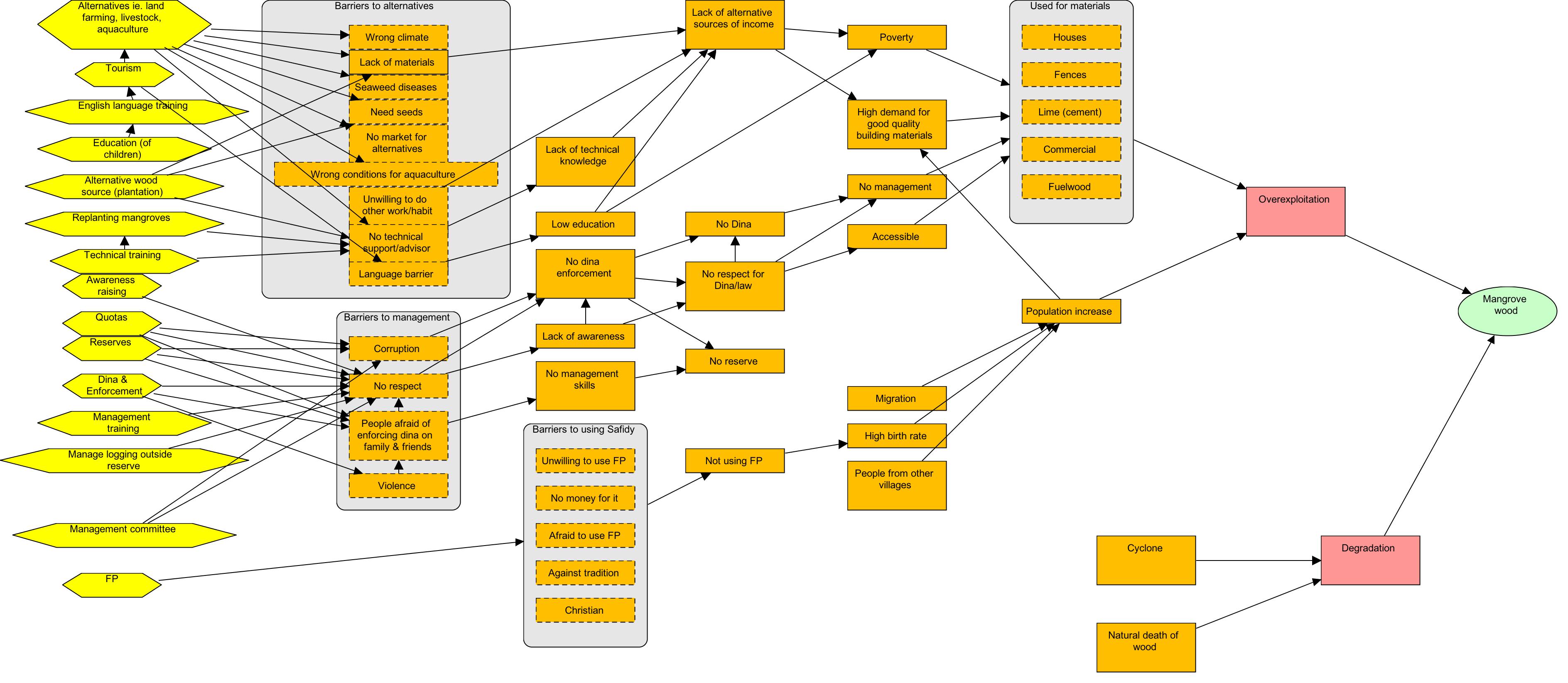
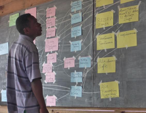
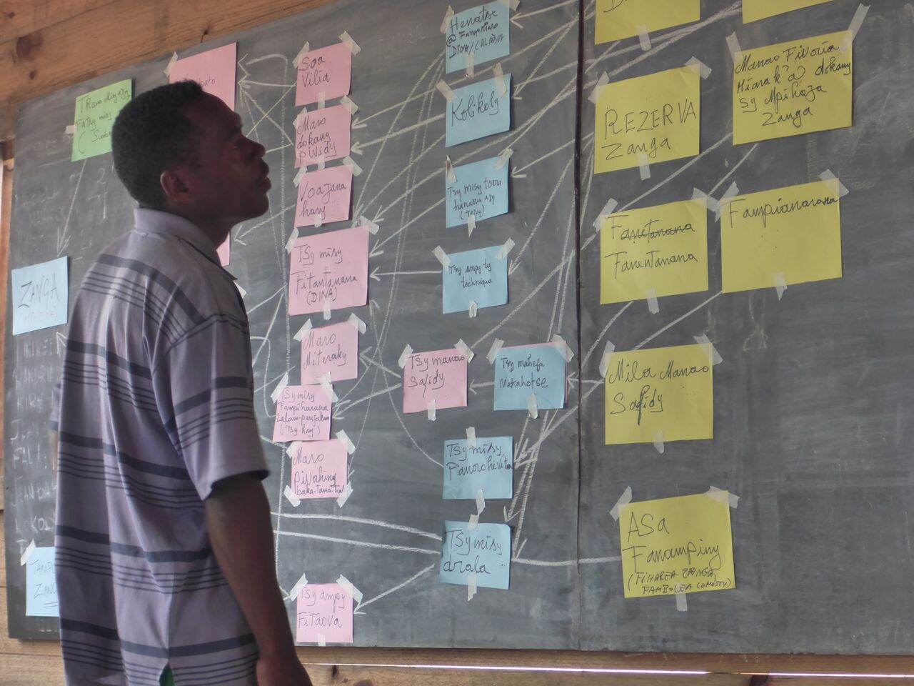
- The participatory concept model and strategy development exercise aims to identify the drivers and underlying causes of mangrove loss; and to identify potential strategies/solutions that could be implemented to reduce threats to mangrove and promote sustainable mangrove use.
- At the end of the exercise the community has developed a concept model. This model depicts the drivers of mangrove loss in their community and the additional factors which contribute to this loss.
- They identify a/many solution(s) and work through the activities they need to implement to reach their desired results through a theory of change (ToC).
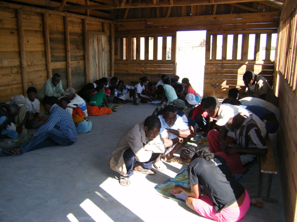
- The exercise is carried out with community members in a focus group format development of the concept model and ToC is completed using different colored paper and chalk.
- Following the participatory meetings the final concept model with threat ratings, and ToC models are digitized using MiradiTM (2013) software.
Enabling factors
- Announcement of the planning is sent to village leader prior to the exercise;
- High participation and presence of all stakeholders during the exercise and participants should be fully aware of the purpose of the exercise;
- The facilitator from the support organization has enough skills and is familiar with the concept model exercise and able to motivate people to express their idea;
- The support organization is able to adapt to the local context (using the available materials).
Lesson learned
To address community reticence and for the better dialogue between the community, employing two community-based facilitators from the village to assist the Theory of change exercise is recommended. It is better to hire people already engaged in the LMMA management (dina enforcement committee, mangrove commission, women’s group) activities. The community-based facilitators are trained by the technical staff from the support organization a day before the participatory theory of change exercise. Volunteers from the community should be invited to present the outcome from their group work, aiming to assess the level of community on the concept model they developed. It is vital to ensure representation from key stakeholder groups and from women and young people who may otherwise be marginalised. If needed, separate women and men in different groups to facilitate open discussion.
Resources
Participatory Forest Management plan
- Participatory management plan aims to support the local community to sustainably manage mangrove forest within the LMMA.
- Using printed high resolution Google Earth map, a first draft management plan is created by each concerned (proposed project area for the mangrove carbon project) village with the boundary of the mangrove zoning (core zone, reforestation area and sustainable logging area).
- When all the concerned villages within the LMMA have completed the zoning, the data from the Google Earth map are digitalized and projected in a big screen for validation. Delegates from each village are invited to attend a workshop for the validation of the mangrove zoning. For the validation, at least four people from each concerned village must attend. Ideally both men and women are elected by villagers who they feel may best reflect their opinions (elders, chef Village).
- Each community determines, agrees and implements the rules and regulations governing each mangrove zone.
- This is conducted through a large village meeting. The support organization facilitates the process until the local law is ratified at the court.
Enabling factors
- A local convention or law enables communities to govern the natural resource management;
- Aptitude of the support organization to incorporate the mangrove management plan into the existing LMMA management plan;
- Ability of the law enforcement committee to enforce the Dina and deal with the fine payment in their respective zone without support/inputs from the government;
- Demarcation of the management zone enables community to observe on the ground the boundary of the mangrove zoning.
Lesson learned
- The support organization must be familiar with the government law as the local laws/conventions (such as Dina) should not be in conflict with the national law. It has proven effective to involve appropriate government actors in processing the Dina (local law) at the village level to make the ratification easy.
- Make sure villages sharing mangrove forest are consulted together through village meeting/workshop for a compromise on the mangrove zoning. For the demarcation at the forest, delegate from village at the AOI must assist the technician staff from the support organization to make sure that the marks/signs are in the right place.
- Color of the marks/signs used for the demarcation should consistent be within the LMMA (e.g color red for the core zone boundary for both marine area and mangrove forest).
Participatory monitoring
- The participatory monitoring aims to develop a greater understanding of natural resource health and the impacts of anthropogenic activities within local communities through a socially integrated resource assessment.
- The participatory ecological monitoring process begins with an initial village meeting to inform the purpose of the activities, select indicator species, monitoring sites and a local monitor team.
- The local monitoring teams are either designated or elected by community members at the village level or can be volunteers. However, they should at least be able to read/write and count. A local monitoring team consists of five people per village and contains male and female.
- The monitoring method is developed by the support organization and the monitoring has a simple design and method to be accessible to anyone, irrespective of educational level (using simple count of cut stump to assess the amount of carbon loss; measuring the tree height with graduated pole wood to measure tree biomass and carbon).
- Local monitors were trained by the technical staff from the support organization on the method before conducting the fieldwork.
Enabling factors
- The support organization assists the community to identify the relevant indicators, these should be the key natural resources or target species providing useful information to allow local community to perceive the effectiveness of the management in place;
- The support organization provides technical assistance in the long term monitoring and builds the capacity of the local monitors.
Lesson learned
- The monitoring method developed must be an effective means of illustrating to coastal communities the benefits of natural resource management. The number of cut stump or number of mangrove mud crab hole could be a good indicator to demonstrate clearly to community the effectiveness of the mangrove management.
- The dissemination of the results of the monitoring helps the community to understand the state of their resources and the amount of carbon stocks in their mangrove forest. The support organization must define the key messages from the monitoring results (the carbon stocks at the mangrove reserve are much higher compared to the unmanaged mangrove forest).
- Local monitor team is not paid but they are given a daily food allowance when they are conducting the forest inventory and carbon monitoring. The income from sale of the carbon credit is planned secure the long term monitoring activities.
Mangrove reforestation by communities
- Reforestation of mangroves in previously deforested or degraded areas helps to improve the health of mangroves and increases the services provided by mangrove ecosystems.
- The area for reforestation area is identified by local community during the participatory mangrove zoning.
- For the viviparous (producing seeds that germinate on the plant) mangrove species (e.g. Rhizophora spp), replanting is undertaken through propagules and for non-viviparous (e.g. Avicennia marina, Sonneratia alba) mangrove species through nursery establishment. The density should be one propagule/plant per square meter to ensure that they have enough space to grow properly.
- The monitoring of the replanting takes place within three to four months after the replanting. The number of plant alive/dead within sample plot is assessed. The number of sample plots (5mx5m) depends on the size of the area replanted but at least three replicate should be done. Community members are involved on the monitoring activities.
Enabling factors
- The reforestation area is identified by community during the participatory zoning process and the plantation takes place when mangrove seeds/plants are available(depends on the fructification season).
- The technical staff provides support to local community on mangrove reforestation (familiar with mangrove ecology and adaptation);
- Propagules are harvested and selected a day before the replanting as sometimes they are not available nearby the site where the replanting takes place.
Lesson learned
- The best time for the mangrove replanting should be checked /decided with community members in advance and this must take place at the low tide during the spring tide.
- Promoting voluntary mangrove reforestation is critical to ensure that it can be continued without external financial support. Motivation in kind (refreshment and biscuits) could be given to the participants when activities are completed to avoid them requesting money. The revenue from carbon payment can be a source of finance for long term reforestation.
- If the propagules are not available near the place where replanting takes place, they can be collected elsewhere.
- The monitoring of the reforestation is allowing evaluating the survival rate of the mangrove replanting. Community members are involved on the monitoring activities to allow them realize the impact they are having and thus keep their enthusiasm for replanting going.
Impacts
- Participatory mangrove zoning has placed 830 ha under strict protection against mangrove logging to enhance carbon stocks.
- 1877 ha of mangrove are harvested by the community under a controlled harvesting regime.
- 1095 ha of mangrove are designated for replantation by community groups in the project area. Community groups (seaweed farmers, youth club, school children, and women’s association) have replanted 12 ha of degraded mangrove to date.