Citizen science data visualization platform

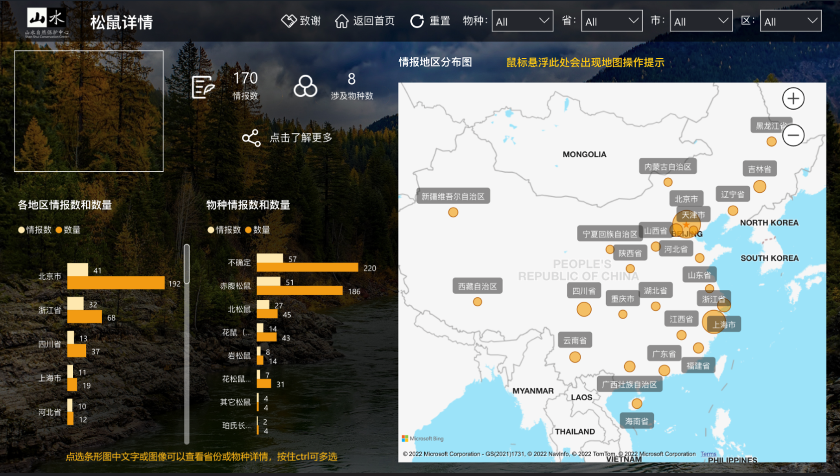
During nature watch campaigns, citizen scientists are invited to observe and record wildlife timely, which not only strengthens the connection between citizens and nature but also serves as a promising species distribution data source. Species record data collected by citizen scientists via online questionnaire automatically flows into the visualization platform database (after data cleaning and manually periodically check) and turns into intuitive and attractive visualized charts and maps (two types: spatial, spatial and temporal) via Power BI. The platform, with both web and mobile version, provides real-time feedback to citizen scientists’ nature watch efforts, boosting their sense of accomplishment and motivating their future participation in nature watch activities. Moreover, since the platform integrates multiple nature watch campaigns with links to web articles about specific analysis of each campaign, it offers a broad range of biodiversity knowledge and enables “virtual nature watch” for citizens to get to know wildlife in other regions.


A brief timeline of the platform:

  • Jan-Feb 2021: form team, analyze analysis, make blueprint
  • Mar-Jun 2021: develop database and platform
  • Jul-Aug 2021: trial test
  • Sept 2021: go live and promotion
  • A well-designed data-collection questionnaire and automatic data cleaning mechanism to ensure data quality and a manually periodically check (normally once a season) to ensure data reality.
  • Visualization methods selection and aesthetic design with the engagement of citizen scientists.
  • PowerBI technology.
  • Citizen scientist WeChat community operation and maintenance.
  • As a public outreach product, it would never be too much for polishing contents and aesthetic design to make the platform user-friendly and attractive.
  • Engaging users in the planning stage and collecting their thoughts is very helpful for identifying user needs.
  • Questionnaires are needed to be well-designed and citizen scientists are needed to be well-trained before recording data. Otherwise, it’s easy to cause data loss.
Camera trap data management system

To accelerate camera trap data workflows, an online data management system along with app-based tools and AI image recognition is being developed supported by technical partners, which consists of:

  • Community-based camera trap monitoring assistant app: the app allows local monitors to automatically record the time and GPS location of camera trap setup/pickup, saving the cumbersome process of collecting data from local monitors and manual data entry. (blueprint: Jun 2019, development: Oct 2019-Feb 2020, trial and use: Mar-Oct 2020)
  • AI image recognition models: AI models help detect animals and identify species in camera trap photos, which greatly reduce the number of photos that need human identification and enhance data processing efficiency.
    • A series of AI models has been trained and/or tested with technical partners, including PU & PKU ResNet18 model (2018), MegaDetector (test only, 2020), MindSpore YOLOv3 model (2021).
  • Online data management platform: camera trap information collected via the app along with photos are upload to a structured cloud database. The data management platform not only supports species identification via AI and human, but also enables global data search and statistics reports. (blueprint: Apr-Aug 2021, development: Sept 2021-Jun 2022, trial and use: Jul 2022)
  • A systematic review of the current camera trap data workflow and translating into technical system development needs
  • Open-source and good-performing camera trap image AI recognition models
  • Cloud resources for AI computing, data storage, etc.
  • Rounds of trial use and feedback to fix bugs and improve the usability of the system
  • Rome was not built in a day. Due to time and resource constraints, we have to divide the system into different modules and develop modules step by step. We believe that each module itself can enhance one or more steps in our workflow and have benefited from modules before they are incorporated into the full system. Yet it is important to have a big-picture perspective in the beginning and make long-term plans for the final system integration.  
  • A system cannot be perfect from the start. When the app first came out and put into use in one community, it did not work as we expected and local monitors reported various types of bugs. We collected and analyzed the feedbacks to improve the UI-design and functionality of the app.
Training and Capacity Building

Training of staff is important to ensure the effective implementation and long-term success of the solution. Prioritise training during the designing and deployment phase, as well as after the deployment to ensure continued use of the solution.

  • Technical officers or champions to drive the training and use on the ground improve the chance of success. 
  • Use the organisational reporting tools to track user engagement and usage to pinpoint when and if they are not using the applications as planned. Identify why there may be a problem, and work with them to overcome the problem.
  • Language barriers can be an issue and forms need to be simple for effective data collection.
  • Training should not be seen as a once-off exercise but rather a continuous process.
  • Staff turnover is a reality and organisations need to ensure continuity by always having more than one senior staff member trained on the various workflows and administration of ArcGIS Online.
  • Implementation partners can make training and long-term support of the solution more manageable.
Designing and Deploying Workflows

ArcGIS Online provides a secure and flexible framework for both deploying useful applications and integrating other conservation technology to holistically support workflows related to each initiative that is being implemented by a protected area. The foundation of all workflows includes tools for data collection such as mobile survey forms (Survey123), data visualisation (dashboards or web applications), analyses, and reporting. Additionally, the ArcGIS Living Atlas of the World gives you access to the foremost collection of geographic information from around the world to support your workflows, this includes the latest satellite imagery and products such as forest loss.


There are several pre-configured workflows for initiatives that can be unpacked and implemented immediately. These initiatives include:

  • Track Illegal Activity.
  • Monitor Wildlife.
  • Mitigate Wildlife Conflict.
  • Maintain Park Infrastructure.

The workflows are configurable and allows users to customise them based on their needs. Alternatively, organisations have access to all the necessary building blocks to develop entirely new workflows for their own initiatives e.g., a community outreach or public participation initiatives.

  • Listen to and work with the frontline practitioners to understand the problem and define the requirements before designing and deploying the workflow.
  • There are several configurable applications available on ArcGIS Online, understanding how they work and how they can link with each other is crucial in developing effective workflows.
  • Follow the design, deploy, operate, and review strategy to develop a workflow and maximise its impact.
  • Prototype and test before rolling out.
  • Establish essential procedures and guidelines.
  • Follow the best practices and trends.
  • Experience in ArcGIS is hugely beneficial, alternatively use implementation partners to make the process easier and effective.
  • Take advantage of the ArcGIS Community and online training resources.
Publication of ouputs

In order to commit Research-Practice Teams in the Heritage Place Lab on a voluntary basis, it was necessary to establish the production of tangible outputs that would be useful for individuals, institutions and heritage places. The Heritage Place Lab proposed to develop and publish the research agendas resulting from the process, the publication of a special issue on the Journal of Cultural Heritage Management and Sustainable Development (Emerald) which is an important step for academics, and the production of Nature-Culture solutions to be published on PANORAMA. 

- WHLP runs the PANORAMA Nature-Culture Community;

- ICCROM, main implementing partner is itself a research institution and has in-house publishing;

- Partnership established with the Journal of Cultural Heritage Management and Sustainable Development (Emerald) for the development of the special issue.

The process of publishing outputs adds to the process of the online incubator workshops, so it is important to calculate the timing for both processes, as well as counting with resources for editorial work and follow-up. This needs to be established before starting the implementation.

Collaboratively assessing management effectiveness of World Heritage properties

The Heritage Place Lab tested concepts and tools being developed under or in collaboration with the WHL including the Knowledge Framework for Managing World Heritage, Enhancing Our Heritage Toolkit 2.0 (EOH 2.0), as well as the case studies’ database of PANORAMA Nature-Culture Community (https://panorama.solutions/en/portal/nature-culture).  For the purpose of developing World Heritage properties’ practice-led research agendas, the Heritage Place Lab proposed that each Research-Practice Team work on assignments between workshops that were later presented. The sequence of the assignments was designed to feed into the production of the research agendas for each World Hertage property, using the Tools 1, 2 and 4 of the EOH 2.0 Toolkit which aims at assessing management effectiveness. The Teams evaluated the shared understanding of values and attributes, governance arrangements and factor affecting their heritage places, which allowed to identify management issues and research priorities.

- The WHLP is currently developing a number of manuals and tools to support the management of World Heritage properties. These were possible to test during the Heritage Place Lab pilot phase.

- The involvement in the project of authors of these manuals and tools, as well as from practitioners that applied these tools on their sites facilitated the process.

- The manuals and tools have been created for the use of managers of World Heritage and other heritage places, and they were more difficult to understand by researchers. However, in the process of using the tools, it helped researchers to understand management more closely, and to identify management needs and research needs based on issues on the ground, connecting more closely with the sites.

- The collaborative work between researchers and site managers assessing management effectiveness was fundamental to strenghten the research-practice partnerships and enabled the inception of new potential projects and plans within Teams.

Research-Practice incubator online workshops

The Heritage Place Lab functioned as an incubator of practice-led research agendas for 8 World Heritage properties, promoting channels for research to impact on site management and site management to influence research through the implementation of 6 online workshops of 3 sessions of 3 hours each held during the span of 7 months. During these workshops, site management issues were explored collaboratively enabling researchers to test theories and methodologies with site managers working on the ground. Researchers got access to World Heritage properties and gain in-depth understanding of local needs. Site managers became familiar with research methods and co-produced research agendas for their World Heritage places. Over 30 guest speakers from different backgrounds, including researchers, practitioners, officers and international experts provided inputs on specific subjects developed in each workshop. Faciliators provided inputs for reflection and feedback to the Teams on the development of assignments that led to the production of research agendas.

-  Due to the COVID pandemic, the WHL switched to online activities and this allowed for the involvement of researchers, practitioners and experts from all over the world. 

- The online setting was already familiar to most of participants in the project, including the use of interactive applications which allowed for closer exchange.

- Even though participants were used to the online setting, there were constraints with the coordination of time zones (too early for some, too late for others), and therefore, such activities could be better implemented at national or regional level.

- Technical issues of internet connections and access to devices were present in every workshop, limiting the active participation of some of the people involved in the project.

- The lack of physical connection was a challenge, however, the online setting allowed for other types of exchange and connection and enlarging the network (more people could be involved, Teams could organize their work in virtual chat rooms and classrooms).
Pahrump Poolfish Translocation

Once the ponds were established, tours were given to members of the Nevada department of Wildlife and US Fish and Wildlife Service, State and Federal partner agencies responsible for permits.


Pahrump poolfish trapped and transpoted by truck in aerated and insulated livewells from a much larger refugium located in Spring Valley, Nevada.

Regular updates and tours for members of the federal "Pahrump Poolfish Recovery Implementation Team" resulted in project buy-in and collaboration with State and Federal partners.  

Although it took years to reach this point, those years were well spent laying a solid groundwork for success and fostering a sense of community and partnership. This inovative project resulted in considerable positive feedback from local press and social media.

Coordination Platform for Sustainable Pasture Management

A Pasture Coordination Platform was organized in Armenia as a horizontal management network among relevant stakeholders on national and sub-national level. Each party is represented by a spokesperson, who coordinates the functions of the party within the Platform and ensures information flow. A secretariat ensures the operation of the Platform. The rationale for creation of the Platform was the need to promote effective cooperation, exchange of information, as well as coordination of activities among the projects implemented in Armenia, focusing on sustainable management of natural fodder areas.


Since 2018 the Platform has evolved and now more than 10 organizations, institutions, projects and public administration bodies are involved in the Platform’s activities, aiming to ensure viability of programs and investments in the area of animal farming, increase economic opportunities of communities and support income growth of rural residents in Armenia. Key objectives of the Coordination Platform are:


  • Coordination, exchange of information exchange and experience, identification of potential cooperation areas
  • Implementation of joint projects, activities
  • Advocating and supporting development of relevant state policy and legislation promoting sustainable use and management of natural fodder areas


  • The platform has a clear aim: "to improve the situation/ livelihood of the rural population which depends on natural fodder areas while sustainably using and conserving these natural ecosystems”.  

  • The need for coordination, cooperation and exchange was felt by parties both from government as well as non-government organizations. 

  • A memorandum was officially signed to establish the platform. 

  • All members have clearly distinguished functions. 

  • Active participation of the community stakeholders in decision making and coordination of the local projects was crucial. Placing the local working groups in charge of the local implementation not only generated a high level of ownership of the project and ensured the engagement of the community.  

  • The coordination with other development organizations on the local scale was a key factor. The harmonization of these different local interventions resulted in a comprehensive, positive change for the communities. Each intervention was complimented by the others and would not have achieved the same results as an isolated activity. 

  • Based on the memorandum of understanding, the common interest and need of all stakeholders in the platform to cooperate increased their commitment and ensured the continuity of the process. 

  • Multi stakeholder advisory bodies face high risks from unforeseen changes in governmental institutions or even within their own parties. The meticulous documentation of agreements and activities has proven to be an important measure for dealing with this risk.  

GIS and Remote Sensing for mapping pasture areas

Maintaining pastures as a natural resource is easily to been done by the application of GIS and remote sensing tools to develop accurate classification maps, e.g. pastures, hay meadows, grassland. The combination of digital data and spatial technology enables detailed and useful monitoring of aboveground green vegetation biomass and grassland composition. Besides, resources and attributes can be monitored for knowledge management and long-term decision planning.  

  • Mapping of pasture/ grassland ecosystem services and understanding of its contribution to human well-being  

  • Facilitate regular monitoring at the management level 

  • Short-term study of the positive and negative effects on pasture or grassland areas 

  • Existence of relevant legal bases and close involvement of relevant bodies in the planning process 

  • All factors that may affect pastures should be identified as spatial data 

  • Mapping and monitoring changes in grassland vegetation cover is essential to understand grasslands dynamics 

  • Reliable monitoring of changes in vegetation cover in grasslands is crucial for accurate and sustainable land management 

  • Gathering more field/ ground truthing data was one of the important notes 

  • It is vital to test and demonstrate different geospatial analyses to showcase what measures have the most impact on which erosion/degredadion situations and foster understanding for the solutions.