Lionfish control in areas inaccessible to fishers

Where commercial lionfish harvesting is not practical or permitted (such as in protected areas), or if the current fishing pressure is not sufficient to suppress lionfish populations below site-specific management targets, a combination of alternative removal methods can be used to reduce lionfish populations, including:

  • culling by SCUBA, either by protected area managers or dive operators

  • lionfish culling competitions (also known as derbies or tournaments)

  • deep-water traps, whilst still at the design stage, have the potential to be used as a tool within a package of lionfish management actions

Multiple stakeholders may need to conduct one or more of these activities at a given site to achieve a desired level of lionfish suppression.

  • Lionfish management targets must already be known so that ineffectively controlled sites can be identified
  • A lionfish task force must be active so that sites are prioritised for management based on best available knowledge
  • Culling by SCUBA requires an active and informed diving industry, as well as capacity for adequate management and enforcement of regulations (e.g. to prevent divers from targeting other species while carrying out lionfish culls)
  • Given the widespread nature of the lionfish invasion and limited resources, it is unlikely that lionfish populations can be controlled in all areas of conservation importance. Therefore, sites for management should be prioritised via a a lionfish taskforce, in consultation with communities and stakeholders.
  • Culling can cause reef damage if not properly managed: inexperienced divers may damage corals with spears, or special permission for lionfish culling can make enforcement of otherwise prohibited activities difficult (e.g. spearfishing within protected areas). These challenges must be addressed before implementing any programme.
  • Lionfish tournaments do not provide regular enough removals to sustain lionfish population suppression if not coupled with additional strategies. They do however provide an excellent opportunity for awareness raising.
  • Risk of traps causing physical damage to reefs or catching by-catch must be eliminated before traps are introduced.
Implement an awareness raising campaign

In order to establish a commercial lionfish market, it is important to understand the perceptions of stakeholders (particularly fishers and restaurant owners) and the general public towards catching and eating lionfish. For example, in a survey of the general public undertaken in Belize in 2015, around half of respondents who had not eaten lionfish stated that they would not try a free sample because they believed it to be dangerous. Furthermore, lionfish exploitation was significantly associated with knowledge about the invasion.


Once the barriers and misconceptions around catching/eating lionfish have been identified, they can be resolved by developing a targeted outreach programme with the general public and social marketing campaign targeting restaurants and consumers that informs people about the lionfish invasion in a way that reflects local concerns and values. 


Activities may include:

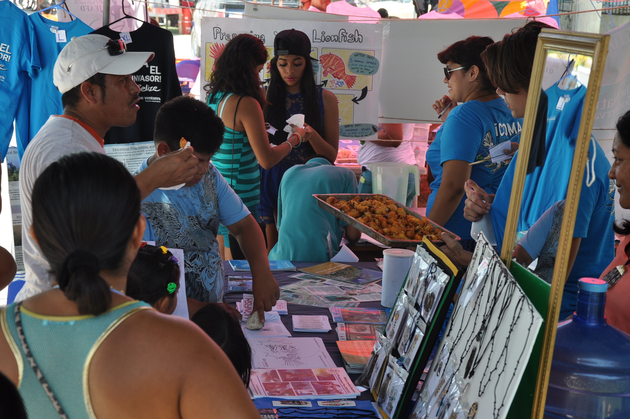
  • cooking demonstrations
  • educational presentations
  • lionfish tasting events (held in partnership with local restaurants/cooks)
  • safe-handling workshops
  • interactive, educational booths with lionfish tasters

Specialized surveys with particular groups:

  • interviews with fishers to understand barriers to lionfish fishing, including the economic viability of lionfish markets compared to traditional fisheries markets
  • questionnaires with restaurant owners / seafood suppliers to identify attitudes about lionfish and barriers to increased lionfish exploitation
  • surveys amongst the general public to assess their knowledge about the invasion, and their perceptions of lionfish as a seafood dish

To reach a wide range of audiences, awareness raising activities can be held at many different kinds of events including food festivals, lionfish tournaments, and with schools, restaurants and recreational dive tours.


​Safe-handling workshops are ideally carried out as a knowledge exchange, led by a fisher or fishers already engaged in lionfish fishing.

Planning the management of the Yaigojé Apaporis Indigenous Reserve and Natural National Park from an indigenous cosmovision

The creation of the Yaigojé Apaporis Indigenous Reserve and Natural National Park marked the beginning of a new relationship model between indigenous peoples and the Colombian Government. It was necessary to seek mechanisms to ensure the governance and integral conservation of their life systems, without interfering with their rights to their territorial autonomy and to the cultural management that they have traditionally carried out. Once the park was created, the process of formulating its Special Management Regime (REM) was initiated. This regime was the instrument through which the joint administration of the park was shared by the Colombian Natural National Parks (PNNC) and the Yaigojé Apaporis Indigenous Captains Association (ACIYA). Establishing the REM required an internal (or endogenous) research methodology, proposed by the indigenous communities and supported by the experience of the GAIA Amazonas Foundation. This methodology was based on the guidelines issued by an Amazon Indigenous Congress that identified the topics to be collected in each of the communities, in order to guide the design of the REM. This approach helped promote the participation of indigenous communities with three representatives and a shaman.

  • Legal figure of the REM that maintains the inalienability of the indigenous territories when they acquire a category of National Park .
  • Development of an internal methodology, led by the GAIA Amazonas Foundation in conjunction with the indigenous organizations, to establish the REM guidelines according to the particularities of the Park and the management regime.
  • Financial availability of State resources, and external support to implement a participatory process to build the REM.

The research process to develop the REM was carried out in two years. The Cooperation Agreement 011 of 2013 celebrated between PNNC and ACIYA established a reasonable timeframe of five years for the construction, formalization, and joint implementation of the REM. This process allowed the following:

  • Rescue ancestral values.
  • Promote greater involvement of young people in the design of the REM.
  • Revalue traditional knowledge.
  • Generat a greater relationship of coordination and management of the area between PPNC staff and indigenous populations.
  • Generate a better understanding of the biological characteristics of the territory and its cultural value, as an input for the design of the Park’s management strategies.
  • Become a replicable model for other REMs in the Colombian Amazon, since it allows the integration of traditional knowledge on the use of natural resources with the policies of PNNA regarding protected area management.
Local social organization and national governmental support for the creation of the protected area

The Yaigojé Apaporis Indigenous Reserve was created in 1998 through a request of the indigenous Tanimuca, Yucana, Letuama, Matapí, Cabayari, Macuna, Barazano, and Yujup-Macú peoples. In 2008, through a consensus in an extraordinary session of the Traditional Authorities and the Indigenous Captains (ATCI), these communities decided to request the creation of a National Park overlapping the limits of the Reserve. The request was based on the consideration that this would eliminate the development of mining operations and other natural resources exploitation that might endanger biodiversity, their sacred sites and, as a consequence, their customs, social composition, and environmental context.

The creation of the Yaigojé Apaporis Indigenous Reserve and Natural National Park has a long process of working with the GAIA Amazonas Foundation, which had the technical and financial support of the Gordon & Betty Moore Foundation. The decision to move to a Special Management Regime (REM) needed the have full local support, ensure the autonomy of the indigenous communities, and strengthen their traditional systems. In addition, it was necessary for them to have negotiation and coordination skills to establish an agreement with the State.

  • Traditional indigenous communities empowered in their decision-making.
  • Colombia's legal framework recognizes indigenous autonomy and their role as public and environmental authorities within their territories.
  • Availability of financial resources from the State and foreign organizations to implement an effective process of informed previous consultation.
  • Successful relationship experience between PNNC, indigenous authority and civil society to strengthen territorial environmental governance.

Once the decision to create the park was made, the following step was the agreement between the Colombian Natural National Parks (PNNC) and the Yaigojé Apaporis Indigenous Captains Association (ACIYA) to carry out a free, informed and previous consultation process that would allow greater social participation and collective construction in terms of definition of limits, area extension, conservation objectives and joint construction of the REM. As a result, the ATCI established management agreements between the State and the Indigenous Authorities stating that the integrated management of the area would be based on traditional knowledge and regulations received in accordance with the way of conceiving the world of each of the seven indigenous peoples and their 19 communities, respecting indigenous autonomy, their rights over their communal lands, their sacred sites, and their cultural values. Thus, in October 2009 the constitution of the Yaigojé Apaporis Natural Park was declared.
 

Community park rangers in participatory management

Participative conservation is a principle by which the protection and conservation strategy that is applied in the PNCAZ starts. This is necessary because one of its challenges is to ensure an effective control and surveillance of the protected area with only 45 park rangers covering 1.35 million hectares and a perimeter of nearly 1,000 km.  These conditions demanded a participatory strategy with the incorporation of communal park rangers. This allowed the inclusion of the fronts of defense of the populations, peasant rounds, and even the local authorities themselves, in the control and surveillance strategies, within the framework of the Master Plan of the Park. All of them have acquired a commitment to assist in the conservation and protection of the park, or to define and plan the settlements of the populations to prevent their advance, and land use change.

  • Control and surveillance strategy with the support of Communal Park Rangers.
  • High-level of involvement of local authorities and local communities in the participative management of the area.
  • Visibility of the importance of forest conservation, its biological diversity and its ecosystem services for local development.

As part of the strategies generated to improve the effectiveness of the PNCAZ's management, the park’s protection front was strengthened. As a result, on top of the 45 official park rangers hired by CIMA and officially recognized by the SERNANP, there are communal park rangers elected in the general assemblies of each community. Communal park rangers rotate every two months among the control posts of the protected area. They directly support the park protection efforts, but they remain integrated into their local communities. This strategy aims to generate a favorable and collaborative environment with the local communities in the implementation of the park’s conservation actions, which allowed for continued co-management and coordinated work in the territory.

Innovative tools for a participatory conservation management model

Managing a protected area of over 1.35 million hectares with a high level of human activity in its buffer zone (2.3 million hectares), required the generation of innovative management tools, focused on social participation. CIMA implements an Intervention Model known as FOCAL, which is currently being incorporated into other protected areas in the country. FOCAL includes tools such as:

  • Strengths and Uses Mapping (MUF): It gathers socio-economic information from the communities and population centers, their needs and perceptions about the area and the use of natural resources, to identify local organizations with which alliances need to be created to implement preservation actions.
  • Participatory Communal Zoning (ZPC): It guides the development process of ecological-economic zoning at a community level to achieve consensus among the population regarding the sustainable use of the territory and its natural resources.
  • Coexistence rules: They enable to reach agreements at the level of the populated center or community, define codes of behavior and provide stability to the planning process and the Quality of Life Plans that are created as a result.
  • Innovative management tools focused on social participation.
  • Empowerment of local communities.
  • Technical assistance and accompaniment for the development of productive processes.
  • Local agreements to support the area management.
  • Fostering improvements in the quality of life of the local populations.

The quality of life plans created by the communities have a 10-year lifespan and are based on communities defining their own concept of quality of life, within the framework of the coexistence rules. The technical support provided by CIMA is key in the planning and implementation of these plans, as well as the financial resources provided by Althelia. Their implementation has enabled institutional strengthening of community organizations and local capacities to implement productive initiatives and perform communal negotiations with the authorities. Additionally, and with the goal of consolidating the quality of life plans, CIMA signs what are known as Blue Agreements or Conservation Agreements with the communities and populated centers, as proof of sustained commitment. As a result, both actors commit to concrete responsibilities through time, and the Head of PNCAZ and local authorities of each populated center take an oversight role to ensure the fulfillment of those commitments.

A co-management model for better financial sustainability of the protected area

Although the PNCA had financial support during the 2008-2013 period, these sources are not considered sustainable in the long term. For this reason, CIMA searched for mechanisms to improve the Park’s financial sustainability.  One of them was to design the Cordillera Azul REDD+ Project. As part of that project, CIMA and The Field Museum of Chicago, as a strategic partner, developed a technical document to verify how the PNCAZ has avoided the emission of more than 1.6 million tons of CO2 per year from deforestation, and almost 13 million tons of CO2 during the 2008-2015 period. This led it to be considered a REDD+ megaproject, validated by international standards such as the Voluntary Carbon Standard (VCS), and the Climate, Community, and Biodiversity Standards (CCB). These standards lent legitimacy and credibility to voluntary markets through certificates of greenhouse gases emissions reduction not issued. Thanks to these certificates, the project was able to obtain its registration in Markit, a tool to manage global carbon credits internationally, which in turn led CIMA to work on carbon credits negotiation processes in the international arena.

  • The 20-year commitment of an NGO as executing organization of the PNCAZ’s Total Administration Contract, which seeks mechanisms to ensure financial sustainability.
  • Global acknowledgment of the contribution of ecosystem services to local communities and at a national level, and the promotion of their economic valuation, which led to the creation of the PNCAZ REDD + project.
  • Articulation of the co-management structure with a financial partner that allows greater sustainability.

As a result of the international carbon credits negotiation processes, by the end of 2014, CIMA secured a key financial partner by the end of 2014: Althelia Climate Fund, with whom it has a contract until at least 2021. This contract enables the PNCAZ to receive funding for the Park’s year-round operations in exchange for a predetermined number of carbon credits generated by the Cordillera Azul REDD+ project.  This allowed the development of a financial sustainability mechanism that has allowed investments in the strengthening of the protected area management capacities, implementation of local conservation initiatives and environmental education, and investment in sustainable productive activities carried out by local communities and social organizations. All this allowed the conservation and protection of the park to become a reality.

Public-Private alliance for the effective management of the protected area

The legal framework for protected areas in Peru favors a co-management and participatory approach, and enables the establishment of Management contracts between the Peruvian Government and private non-profit organizations, as an effective mechanism to support management. In this context, since its creation, the Cordillera Azul National Park (PNCA) has had technical support from the NGO Center for Conservation, Research and Management of Natural Areas - Cordillera Azul (CIMA - Cordillera Azul). Years later, in 2008, the State signed an agreement with CIMA for the total administration of the Park's operations for a period of 20 years. Under this framework, a Global Development Agreement (GDA) was signed with the United States Agency for International Development (USAID,) the Moore Foundation, the MacArthur Foundation, the Field Museum of Chicago and CIMA, to combine efforts towards the conservation of the PNCAZ and to have financial support during the period 2008-2013. This allowed to establish a long-term vision for the adaptive management of the Park, to implement a participatory management model, and to achieve greater financial sustainability through the leverage of funds for the PNCAZ.

  • The legal framework for protected areas in Peru promotes co-management and the establishment of public-private partnerships.
  • Long-term commitment (20 years) of an NGO as the executive organization for the PNCAZ Total Administration Contract.
  • Coordinated work between the NGO managing the Park and the public management organization, local and regional government, and communities in the buffer zone.

The co-management mechanism implemented through CIMA's PNCA Total Administration Contract was key to the effectiveness of the park management. The reason is that CIMA not only has the necessary skills to manage protected areas, but it has also implemented fundamental and innovative elements to achieve this management. One of these elements is to have become an articulating agent that allows to promote and reach the involvement of the approximately 120 villages and native communities that live in the ​​buffer zone, as well as of the regional and local authorities of the four Departments where the Park is located (San Martin, Loreto, Ucayali and Huánuco). This model seeks the empowerment of communities next to the area for conservation and local development. Their work approach responds to the PNCAZ’s Master Plan, developed through the Management Committee of the protected area, CIMA, and SERNANP.

Conservation mosaics: An effective strategy to consolidate great expanses of protected territory in Brazil

The National System of Protected Areas Act, enacted in July of 2000, established the Conservation Mosaic Approach. Mosaics are a “set of Conservation Units (UC) of equal or different category that are close, adjoining or overlapping, and other public or private protected areas” that are managed in an integrated manner, according to the goals of each UC.

To address the challenge of managing socio-environmental conflicts and optimizing human, financial, and material resources, the Bajo Río Negro Conservation Mosaic was established in 2010, with a total area of 7,329,220 hectares, and integrated by 11 UC, among them the Jaú National Park and the Unini RESEX. The implementation of this approach prioritizes conservation processes for larger areas, which allows for landscape integrated management of areas along the Jaú and Unini rivers to the north, and the Bajo Río Negro to the south of the mosaic. By viewing the protected areas like parts of a larger unit, functional and interconnected, it was necessary to include a participatory methodology in the design of management plans, that encouraged the participation of multiple actors in the decision-making process related to the administration of the territory and its natural resources.

  • The Conservation Mosaic management approach enables the integration of multiple actors and opportunities of technical and financial assistance for territorial management.
  • Linkage of efforts in areas with a shared territorial identity, to achieve a common goal of conservation and sustainable management of natural resources.
  • Institutionalization of an Advisory Council as a mobilizing force in the area.
  • Strategy planning at a landscape scale.

The key elements for the integrated landsape management included the implementation of an Action Plan for the mosaic, the creation of an Advisory Council to support decision-making, the development of participatory methodologies for zoning community use and subsistance areas, and the strengthening of local capacities through training processes for natural resources management, sustainable agriculture, tourism, and rights and obligations of the local communities.

The benefits of integrated management are: resource optimization; integrated landscape planning; coordinating protection activities; environmental education, monitoring and awareness in the region; the possibility of developing an integrated territorial identity based on the characteristics of the region; the development of unified strategies for the valorization of products for communities around and inside the conservation units; and the facilitation of agreements and conflict resolution.

ARPA: the most important conservation program for tropical rainforests in Brazil, and mechanisms of financial sustainability of the Jaú National Park

The Jaú National Park represents one of the largest extensions of protected tropical rainforests in the world, protecting a great extent of the Aguas Negras river basin. Due to its prominence, this protected area was prioritized by the Amazon Region Protected Areas Program (ARPA),  a program created in 2002 by the Brazilian Government and managed by the Brazilian Biodiversity Fund (Funbio).

The ARPA program has the financial backing from the Global Environment Facility (GEF), the German Government, the World Wildlife Fund (WWF), the Amazon Fund, through the National Bank for Economic and Social Development (BNDES), the Moore Foundation, and currently, private companies that act as donors to the program. The program is designed to last 13 years, and it’s aimed at expanding and strengthening the Brazilian National System of Protected Areas in the Amazon, through the protection of 60 million hectares of conservation units in the Amazonian biome, and ensuring financial resources for the management of those areas in the short and long run. It is implemented in three independent and continuous phases: Phase I between 2003 and 2010, Phase II between 2010 and 2015, and Phase III with a deadline of 25 years.

  • National context of greater concern for the preservation of the Amazon region and sustainable development, with the global acknowledgment of the importance of tropical rainforests.
  • Elaboration of regional public policies for the conservation and sustainable use of tropical rainforests.
  • ARPA Program Budget for 2003-2015, of 236 million dollars.

The inclusion of the Jaú National Park in the ARPA program was an essential strategy for its conservation, given that ARPA is one of the largest programs in the world for the conservation of tropical rainforests, implementing a model that ensures the quick and effective gathering and application of financial resources.

During Phase I, ARPA was dedicated to the creation of new protected areas. During Phase II, it was focused on consolidating the program. Phase III is aimed at consolidating 60 million hectares of protected areas in the Amazon at a Federal and National level, and reaching financial sustainability.

The support provided by ARPA made possible the creation of the Unini River RESEX, consolidating the RESEX and the Jaú National Park through the funding of projects that enabled the generation of conservation value and increasing the financial income of local communities. This contributes to the sustainability of both conservation units at a social, financial, and management level.