Forming and strengthening alliances for communication, capacity development and implementation, including financing
Successful EbA planning and implementation needs strong alliances – among different public sectors and levels, with the private sector, with civil society and research institutions. The project strengthens existing partnerships and supports the formation of new ones. These alliances are the breeding ground for awareness raising and communications with regard to EbA (results are e.g. a multi-media strategy, videos and other information material) and joint capacity development measures such as training courses. The creation of the “Climate, Ecosystems and Communities Knowledge Network” for advancing in the search of EbA solutions for the recovery of the Virgen Coastal Lake and its channel system in Cartagena is one tangible result. The education sector has incorporated the EbA approach into educational programs. In this way, the stakeholders bring together complementary competences and knowledge, financial resources as well as contacts and networks. The different initiatives have already attracted interest by the port sector, representatives from the tourism industry and the National Association of Industries, among others. A broad-based financing strategy for EbA is being worked out together with national and regional actors.
*Plan 4C as general framework and setting for decision-making. *EbA measures are embedded in the existing overall adaptation strategy and not an end in itself. *Willingness to cooperate beyond institutional boundaries for improving environmental factors and human wellbeing.
*Scaling up actions and recovering hydrologic dynamics of the Virgen Coastal Lake requires the coordinated action of government institutions, local communities and the private sector, in combination with the creation of appropriate incentives. *Alliances and strong cooperation is an important success factor as it helps mobilize the necessary technical and financial resources. *A strategic capacity development approach in the field of EbA for project partners is key to build and sustain a shared understanding of the core problems, underlying causes and options and interest in action. *Effective communication of EbA benefits is needed to ensure the involvement and commitment of different stakeholder groups. It should always be prepared in an appropriate language and address their specific needs. *Strengthening local capacities so that authorities, the private sector, academia and communities make better decisions to conserve ecosystems and reduce vulnerability to climate change.
Knowledge exchange visits at local and national level

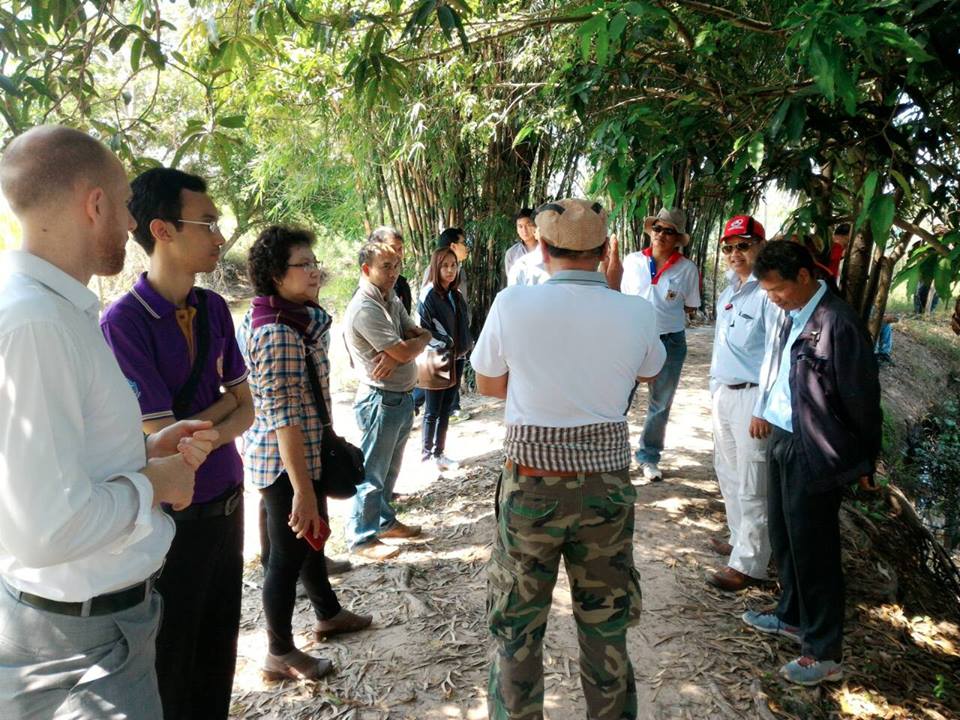
The set-up of site visits and exchange of stakeholders and decision makers between the three different pilot river basins was a great method to foster exchange and mutual learning on potential EbA measures across river basins and across institutions. This exchange triggered important exchange on the feasibility of measures, their application in different locations and the possibilities for upscaling. Further, on one hand a friendly competitive spirit could be sensed in regards to which river basin would have the better ecosystem-based water management sooner. On the other hand, institutions which are in competition to each other came together and started cooperating.

• Exchange of local lessons learned • Cooperation across river basins • GIZ project as neutral framework allowed non-cooperative institutions to come together

- Tangible examples and good practices on EbA measures help relevant stakeholders to get a better understanding on EbA concepts and its benefits. - At the same time, EbA measures cannot simple be copied to other river basins and relevant people need to be made aware of the need for river basin-specific vulnerability assessments.

Identifying MPA boundaries in the field
The boundaries of an MPA (or zones within an MPA) should be identifiable while on the water. Traditionally, inshore MPA boundaries were referenced to some obvious natural feature or by using a distance from a feature like the shoreline. In some instances, physical demarcation of marine boundaries has occurred using fixed markers on the land or floating marker buoys, but there are significant costs to install and maintain such infrastructure. For deepwater, open-ocean conditions or for large MPAs the placement of marker buoys is extremely difficult, if not impossible, and the cost is prohibitive. For these reasons, MPA managers delineate such offshore boundaries using GPS coordinates (see Resources for Coordinate-based zone boundaries). Experience has shown that submerged features (e.g. depth contours, reefs, banks, shipwrecks, etc) may be hard to identify so should not be used for marine boundaries. Florida Keys National Marine Sanctuary has considerable experience with installing offshore infrastructure for marine boundaries; FKNMS staff have installed >100 yellow boundary buoys marking marine zones; over 120 boundary buoys and/or signs marking Wildlife Management Areas, and are responsible for > 500 mooring buoys.
Best Practice approaches for boundary development are available (see Resources) to develop effective and accurate marine boundaries and definitions; these can help reduce boundary misunderstandings and possibly litigation.
• Mooring buoys can be excellent management tools, but concerns exist they can negatively impact marine resources by attracting and concentrating boaters, divers or fishermen to one location. Education programs must therefore accompany any mooring buoy program, with monitoring to assess any impacts. • Reference to an identifiable geographic feature can help clarify a boundary location; however, the geographic coordinates will also help enforceability. • An issue with MPA boundaries includes fishers ‘fishing the line’ with resulting edge-effects (i.e. MPA edges being more heavily impacted). • If only a single land-based marker is used, the boundary may be seen to differ depending on which line of sight is viewed. • Haste and inexperience can lead to poor MPA boundaries. Always ground-truth boundaries for accuracy and completeness. • Shorelines may be ambulatory (i.e erode or accrete) so boundaries may be a problem to enforce if they move or are difficult to define.
Data for better enforcement
Fin Fighters works on the ground and is able to collect any evidence of IUU that may be occurring or is unreported. In the fishing ports and markets we are able to witness firsthand the sale and movement of any CITES listed species or evidence of illegal shark finning. The evidence we have collected so far from the first 2 years of this 5 year study will be amassed and produced in reports (together with our genetic results and data) that will be presented to the fisheries officials and governing bodies. Our aim with this is to prove that despite restrictions and laws (such as CITES and ICCAT) being agreed to by Moroccan governance – they are currently not being managed or enforced effectively. We are currently producing an education scheme, that we hope the Moroccan fisheries ministers will approve (with the reports and fishermen surveys as evidence to back this up) that we will run out across the country in ports and markets. This will provide basic knowledge of different species and outline the laws and restrictions as well as give explanations for why they are necessary.
It is important that we can provide quantitative as well as qualitative data for presentation to officials – so that the need for our program is clearly evidenced. By producing evidence of consistent law breaking (unintentional and intentional) or problem areas where species are targeted – we can clearly show the need for specific areas to be addressed and programs to be established.
The most important lesson we have learned in this work so far – is that the fishermen themselves may not be to blame for breaking the law, there is simply a lack of information and a definite lack of enforcement. We are hoping therefore to work with the fishermen to make the enforcement of the laws that protect their livelihoods more accessible and part of the every day. It is necessary to exercise extreme caution when collecting evidence of rule breaking and not to act on this rashly or without certainty – this is the reason we are collecting evidence for reports rather than chasing prosecutions straight away; as often this can drive activities underground and make monitoring the situation much harder as well as promote the creation of black markets.
Data from landings and fishing surveys
Surveying fishermen allows a valuable insight to what is being landed across Morocco - and in what quantities, if species are effectively reported and if not why not, what methods are being used to catch elasmobranch species and if species are being heavily targeted for commercial purposes or simply by-catch. Through this we have understood that many fishermen have little or no knowledge of laws and restrictions on shark/ray species and that many international and national trade/catch policies are not translated from management level to the fishermen themselves – who are unaware they are breaking laws. We are therefore working with artisanal fishermen to establish the beginnings of a species education program and on basic training in DNA data collection from their landed catches.
The most important element is communication. We had two translators on our volunteer team, French and Arabic speaking, which ensured that information was taken correctly. Every team member has to understand the situation they are faced with when meeting and discussing with fishermen. E.g. if a large protected species is being landed and sold –it is not appropriate to question the fishermen aggressively or to get in the way of their work, as this simply cuts of their desire to communicate with us
In the future we hope for this to be made easier in some localities by obtaining more official sanctions from the fisheries ministers and port authorities – as many fishermen in Morocco can feel un-easy with women and scientists asking questions unless they are with a port official, however this is only the case in 1 in 5 ports. Photography is often frowned upon in ports due to either religious beliefs or simply concerns with sanitation and officials worrying that they are being monitored on health and safety standards. It is always polite to ask before taking photographic evidence – however in certain circumstances it is necessary to obtain data – and this is usually a judgement call by the team or individual present.
Citizen shark scientists
Volunteers are trained to conduct genetic sampling and necropsies and to gather data by monitoring landings and surveying fisherman. This creates an opportunity for conservationists and concerned citizens to have a positive impact and learn new skills for the benefit of species conservation. This has also enabled the collection over a wide area of a vast amount of viable data for scientific studies. Ultimately it means that Fin Fighters are able to provide a much needed data resource in data deficient areas for poorly understood populations. The participants are trained to ID species from various body parts and to take ID images for our data bank. Some of our volunteers request to be taught more in-depth collection skills such as sampling either in situ on the ports, or in controlled environments. Others further their involvement by learning how to carry out necropsies and to extract samples of specific material – such as sperm, or stomach contents for later study. The volunteers (or Citizen Shark Scientists) are also taught how to survey fishermen, and fishing equipment, and to understand fishing methods.
It is important that volunteers work well in a team and in high pressure situations to collect data that is controlled and that all reporting is carried out in a reasoned manner – without assumption. Many of our volunteers have skills that can be useful in an investigation – such as a second language, or a past working in the fishing industry, this enables communication with fishermen and officials easier and helps to build confidence within the voluntary team.
We have learnt that working in this way requires a great deal of patience and understanding of the different ways people process information. It has led to tailoring different learning activities to fit individual’s needs and in doing so has also taught us new techniques of describing the practical elements of our work. Whilst Fin Fighters operate a democratic and fair approach to our investigative process – including every member’s opinion in our decision making; It is also necessary for the investigation for the director to maintain a leadership role throughout. Ensuring every members voice is heard is important, but this then needs to be translated in to cohesive action and managed in a safe and proficient way – we found in the field that having a leader in final decision making and implementation way key to the success of the investigation process.
Transparent sharing of information
The results of the project have been shared with Belize’s Ministry of Forest, Fisheries and Sustainable Development (including Coastal Zone Management Authority and Institute and National Climate Change Office) and the Ministry of Tourism to facilitate replication, and uptake of the process and recommendations. The results have also been shared with local communities, local NGOs, land developers and the private tourism sector to build capacity, awareness and implementation of greener landscape practices within the coastal zone.
• Continuous and transparent sharing of information and best practices with communities and stakeholders. • Interest and wish to conserve the natural ecosystems exhibited by local communities, stakeholders and government decision-makers.
Working in partnership and building a sustained relationship with local communities and stakeholders (e.g. private tourism sector groups) on the Peninsula opened doors for us to influence better practices on the ground. This is very important since these groups can play important roles as advocates, sponsors, partners and agents of change. WWF has been carrying out conservation and climate adaptation related projects on the Placencia Peninsula since 2007, and over the years have built credibility within and among the communities and sectors on the Peninsula. Where there is trust, communication can be very effective.
Promotion of active participation
The development of the capacity of fisherfolk to manage their organization, through training activities in leadership, business, communications, advocacy and representation is important in contributing to strong fisherfolk organisations and appropriate representation and participation in fisheries governance. This capacity development is based on identified needs, focused on priority areas and conducted in collaboration with appropriate partners.
• Strong partnerships with fisheries administrations, academia, NGOs and FAO. • Committed fishers. • Existing policy/legal framework. • Funding opportunities to conduct training activities, and provide resources.
• Requires consistent, ongoing effort. • Capacity development is a long term undertaking and requires solid partnerships. • Small-scale fishers and their organisations are unable to support required training activities and benefit from dedicated partnerships.
Monitoring of the comeback of the "good life"
From the beginning of creation of the ICCA, the local community engaged in the monitoring of quality and quantity of fish catch, socio-economic change and ecosystem health.
Only available in French. To read this section in French, please download the document "Blue Solution Template in French: ‘L’aire du patrimoine communautaire KAWAWANA: La bonne vie retrouvée par la conservation’” from the bottom of this page, under 'Resources'.
Declaration of an Indigenous Community Conserved Area (ICCA)
The Fishermen Association of the Rural Municipality of Mangagoulack (Casamance, Senegal) was informed that— following international CBD decisions and IUCN recommendations— Senegal was promoting and respecting locally established “community conserved areas”. The association thus mobilized the community to create Kawawana ¬ (“our local heritage to be preserved by us all”) in its ancien estuarine territory. In Kawawana, the ancient governance and management rules– renovated and agreed upon also by the municipal and regional governments – are finally again respected.
Only available in French. To read this section in French, please download the document "Blue Solution Template in French: ‘L’aire du patrimoine communautaire KAWAWANA: La bonne vie retrouvée par la conservation’” from the bottom of this page, under 'Resources'.