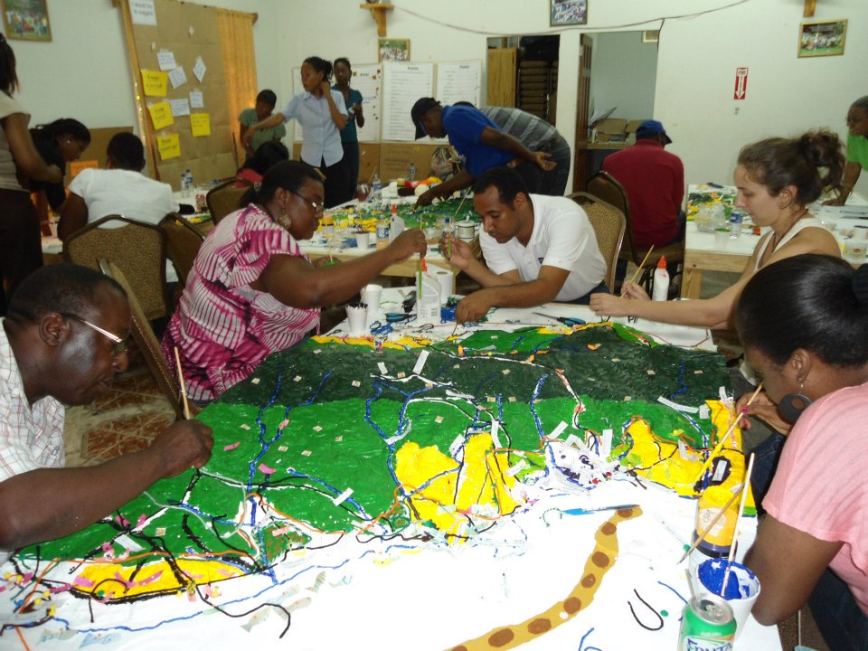
Participatory three-dimensional modeling (P3DM)
P3DM integrates local peoples' spatial knowledge with elevation data (land and sea) to produce stand-alone, scaled and geo-referenced relief models to inform, for example, marine protected area planning. In a facilitated process of model building, stakeholders depict their knowledge of land/sea use and features on a scaled model using pushpins (points), yarn (lines) and paint (polygons). On completion, a scaled and geo-referenced grid is applied to facilitate data extraction or import. Data depicted on the model are extracted, digitized and plotted. The model remains with the community.
• Access to topography maps and GIS expertise • Thorough analysis of who are the stakeholders that need to be involved in the process • Buy-in of key leaders (community leaders, local media and government personnel) to mobilize participants. • The site(s) for building a P3DM model, as well as storing it when completed, needs to be in a location convenient for the participants.
• Various strategies are needed to mobilize and engage stakeholders. • The P3DM methodology must include facilitated sessions to improve understanding of the basic concepts of climate change and to analyse the impacts of climate change on their livelihoods. This facilitates analysis of impacts and recommendations for policy and action. It also supports civil society engagement in climate change vulnerability assessment and planning. · Model building is very time intensive for facilitators as well as participants. The process can take anywhere from 5-15 consecutive days depending on the scale of the area and the number of participants being targeted.
International Fishing Improvement Projects
We design and implement international fishing improvement projects (FIP) in the region with an all-encompassing multi-stakeholder group to identify, assess, and improve the fishing practices of sand bass.
Importance of multi-stakeholder engagement and federal/state/local government support.
Importance of acquiring good data to inform decision-making. Ambitious timelines are prone to delay due to social, political, and economic reasons.
Responsible Seafood Production Co-ops
We partner with co-ops and NGOs to empower fishermen and their families to rescue value by catching and producing the best quality, higher sustainable seafood. This cultivates demand for their exquisite seafood among distinguished customers.
We work hand in hand with chefs to make the very most of our exquisite seafood and ensure highest level of culinary appeal.
Essential to create a commercial market for high-quality seafood; requires diverse partnerships and creative marketing strategies to attract consumers and retailers.
Economic Acumen
We rescue value in fisheries in order to make fishing more profitable based on quality rather than volume.
Each fisherman has adopted at least one of a range of sustainability measures including fisheries reserves, catch quotas, and size limits.
We source only resilient species from these fisherman.
Partner fishery selection criteria and process

To maximize SmartFish’s impact, we drew on empirical research and years of experience to establish fishery selection criteria. Fishery partners must:


           a) Be formally organized, with effective institutional structure (eg a cooperative) that includes mechanisms for decision-making, for enforcing group decisions and a collective understanding of and commitment and adherence to fishery sustainability principles;

           b) Have previously and formally adopted sustainability measures (eg: fishing reserves, daily catch quotas, or size limits);

           c) Target biologically resilient species.


We established an Impact Division within SmartFish to determine the elgigibility of potential fishery partners as well as to track the social, environmental and business performance of partners before, during and after our interventions. Please see Impact Evaluation building block for more information.

Mexico's strong tradition for cooperatives coupled with legal and fiscal underpinnngs for them have resulted in among the strongest fishing cooperatives worldwide. We prefer to work with co-ops that have self organized to ahcieve strong social and environmental performance. However we are also happy to collaborate with groups that have been assisted by NGOs (eg COBI AC, Niparajá AC, and ProNatura Noroeste AC) to improve social and environmental performance enough to meet our strict criteria.

Cutting corners on these criteria can create problems. While we would like our model to work for all fishers, if they are not formally organized, with effective institutional structure (eg a cooperative), our Value Rescue interventions cannot function.  


We thus partner with fisher groups that are already performing well socially and environmentally. Groups that are impriving are considered, and for this we depend on strong collaborations with NGOs that specialize in the improvement of coooperatives' social and environmental performance.

Regional knowledge transfer
The catalog fills an important information gap in coastal development to reduce impacts from climate change and extreme weather events. After the core team completed the catalog, they expanded and engaged new partners. The catalog and the process was presented in a variety of settings and sectors such as urban development seminars and congresses, the national Chamber of Construction, architects and engineers’ associations and at risk-reduction meetings. As a result, there are many more actors interested in learning about the practices, as well as with the knowledge and tools needed to implement them. Other vulnerable coastal states and countries are interested in the approach. The core partnership is planning training sessions in the state where they are located, and training will soon be conducted in other cities in México to further disseminate the practices.
Partners have a good standing and enjoy recognition with other relevant organizations, which eases the acceptance of both catalog and approach.
It is important to identify what stakeholders’ need, and it is critical to develop a concise product to fill that need.
Development of national policy frameworks

The existence of robust policy frameworks facilitates the design and implementation of local and national blue carbon initiatives. These policies promote official government support and the foundation for institutional roles, and offer links with other national and international policies, mechanisms and strategies (such as NDCs, REDD+ and NAMAs). The policy building process starts with informal consultations with national authorities to map actors, gauge their interest and obtain their support. As these are national-scale constructs, strategic advice and facilitation of the process is important.

Of utmost importance is to garner the interest and support of national authorities in decision-making positions, as policy development is a government role and must not be imposed onto a country. The existence of other environmental, coastal-marine or climate change policies enables the alignment or incorporation of blue carbon policy notions within pre-existing policies. The availability and communication of sound science for the public is also important during policy development.

Our experience has been that an initial ‘socialization’ (supply, introduction and communication) of basic blue carbon information and principles is needed through formal and informal meetings with country officials at multiple levels of decision-making. Then, a clear understanding of current country needs and priorities, and how they can be met through blue carbon actions, should be considered to ensure the process is compatible with on-going national processes and international climate change and conservation commitments. The role of the people facilitating the policy process is key to deliver sound information, to understand country needs, to ensure that the interests of different actors are met, to negotiate complex matters and to mediate conflicts that may arise. The pace at which governments respond to specific processes is not necessarily compatible with the short-term goals of local project development and implementation or international cooperation.

Ecosystem services valuation

Quantifying the value of ecosystem services provided by mangroves to the local communities is a required component of blue carbon projects. This informs the design of Payment for Ecosystem Services (PES) schemes. As a full valuation is challenging and costly, priority services are chosen through a participatory consultation process with local communities. Raw data are collected locally and mined through bibliographic searches and interviews. Results emphasize the importance of coastal-marine ecosystems with decision makers, as mangrove losses can be explained as capital losses.

The availability of local and national data is a determining factor for an adequate valuation of ecosystem services. Even when those data are not available relationships with local officials may provide useful expert criteria and inputs. Also, the participation of the communities in the diagnostics to identify and later quantify priority services is important to guarantee their buy-in into the process. A clear understanding of local livelihoods is also necessary.

Local perceptions of what constitutes a “priority” ecosystem service for valuation may differ from that of project developers and researchers. In addition, data constraints may limit the extent of the valuation study. It may thus be necessary to negotiate with locals during the preliminary diagnostics phase what services meet their needs and those of the project, and which can be valued. The wide range of services provided by mangroves and surrounding coastal-marine ecosystems make a full valuation exercise very challenging. Thus, most valuation studies are partial and depend on a set of assumptions and a variety of different methods. Good working relationships with government representatives in charge of data processing and archiving, as well as a solid understanding of the details of the local livelihoods and business models is highly advantageous, which is why a livelihoods study should be conducted in parallel.

Geospatial and emissions modeling
The assessment of historical land use dynamics of coastal areas relies on geospatial analysis of a sequence of satellite images. It classifies land use categories and how their area changes over time. Using these dynamics, the quantification of carbon emissions associated with the conversion of mangrove forests to other land uses can be estimated through modeling. This provides both an assessment of carbon stocks lost as well as an identification of areas suitable for restoration. This can also be tied to estimates of natural capital lost over time.
The main requirement is the availability of a consistent series of satellite images that is free of cloud cover and offers enough spatial resolution to differentiate mangrove stands (and types), surrounding agriculture and other human uses of the landscape. Local or national capacities for remote sensing processing and advanced GIS analyses of coastal features is also important. Emissions modeling is a challenge, which needs to be resolved through enhanced capacities.
Although GIS facilities and trained personnel are readily available, capacities to properly classify different types of mangroves within a stand are still lacking in the GIS/remote sensing field, especially when higher resolution images are used. We have been exploring the application of innovative image processing and classification techniques with good results. However, the process cannot be fully automated and the analyses require time and expert judgement to complete. Access to a consistently cloud-free series of images across different dates is a challenge. This is coupled with the malfunctioning of a well-known satellite, which further limits the availability of images suitable for analyses. Scaling-up analyses from local to subnational to regional scales presents additional challenges of spatial resolution, data volume for analyses and time required.
Social and ecological vulnerability assessments
To construct a robust blue carbon project, a clear understanding of local livelihoods and how they are tied in with the surrounding mangrove ecosystems is obtained through a livelihoods assessment. This includes an analysis of the social vulnerability to the effects of climate change. The social and ecological elements of the assessment provide information that helps conceptualize targeted blue carbon projects with interventions that benefit local communities by increasing their resilience, diversifying their production base, and enhancing their governance and human capital.
Previous contacts with local authorities, NGOs and local leaders is required. The project needs to be explained in a non-technical manner so that locals with varying degrees of education and interest can at least be aware of the project components and the potential benefits for the community. Well trained professionals and experts in community diagnostics, group facilitation, and conflict resolution are required to navigate social nuances that a casual observer may miss.
The priorities and perceptions of local communities and organizations may differ frequently and significantly. Local interest in a project may be minimal or non-existent, and expectations of project designers can differ from those of the communities. Outside observers may not fully understand local dynamics, conflicts, challenges and needs so it is important to have people trained in social science tools involved at all stages. Having a local leader buy into the idea of a blue carbon project helps build confidence among the community, increases their participation, and opens the door for more transparent dialogues with the community. Being open to local needs and wishes, and taking time to know the people and become immersed in their day-to-day lives can yield useful information for project development. Climate change effects may be minor priorities in comparison with far more urgent health, education and infrastructure needs of the community.