Restauration des zones humides et des îles-barrières pour la protection contre les tempêtes dans le nord du golfe du Mexique
Solution complète
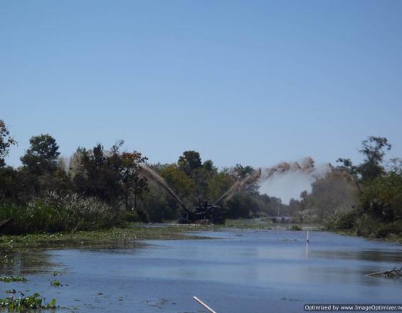
Dragage par pulvérisation : application d'une fine couche de boue de dragage sur le marais.
Mark A Ford, National Park Service, US
La côte nord du golfe du Mexique subit fréquemment les effets des systèmes météorologiques tropicaux et de l'élévation du niveau de la mer. Les communautés sont menacées. La restauration de deux parcs nationaux américains joue un rôle dans la protection des communautés côtières. La réduction des risques de catastrophe est renforcée par la restauration des zones humides et des îles-barrières. Ces écosystèmes réduisent l'intensité des vents et des ondes de tempête et protègent les digues de réduction des risques.
Dernière modification 06 Feb 2023
6864 Vues
Galerie de photos et de vidéos


Contexte
Défis à relever
L'élévation du niveau de la mer et l'augmentation de la fréquence et de l'intensité des tempêtes majeures font que la restauration des écosystèmes côtiers est plus nécessaire que par le passé. L'augmentation des inondations, l'intrusion d'eau salée et l'empiètement du développement humain entraînent la perte d'habitats côtiers dans des endroits non protégés. En outre, le manque de financement nécessaire pour les projets de restauration à grande échelle limite notre capacité à mener à bien les projets prévus.
Emplacement
Nord du golfe du Mexique États-Unis
Amérique du Nord
Traiter
Résumé du processus
Ces techniques de restauration et leurs résultats fonctionnent ensemble pour fournir un ensemble de lignes de défense multiples pour les communautés côtières contre les impacts du changement climatique, de l'élévation du niveau de la mer et des ondes de tempête. Chacune d'entre elles est utile en soi, mais combinées, elles créent une réduction des risques côtiers plus forte et plus résiliente. Il n'y a pas d'ordre particulier dans lequel ces blocs doivent être complétés. Par analogie, ils sont comme les membres d'une équipe, chacun ayant un rôle à jouer dans l'objectif global de protection des côtes et de réduction des risques de catastrophe.
Blocs de construction
Obturation d'anciens canaux
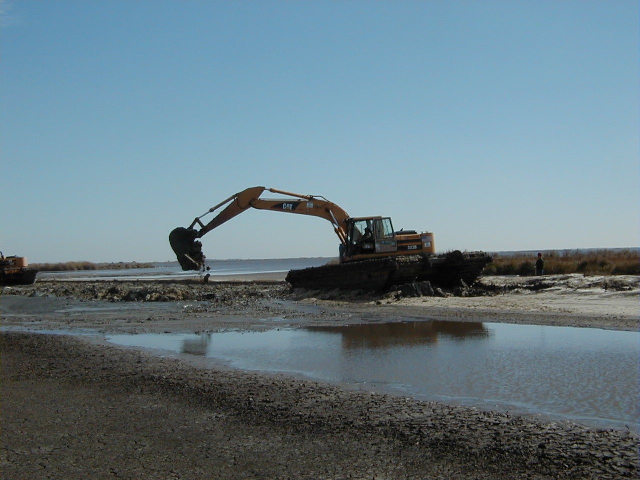
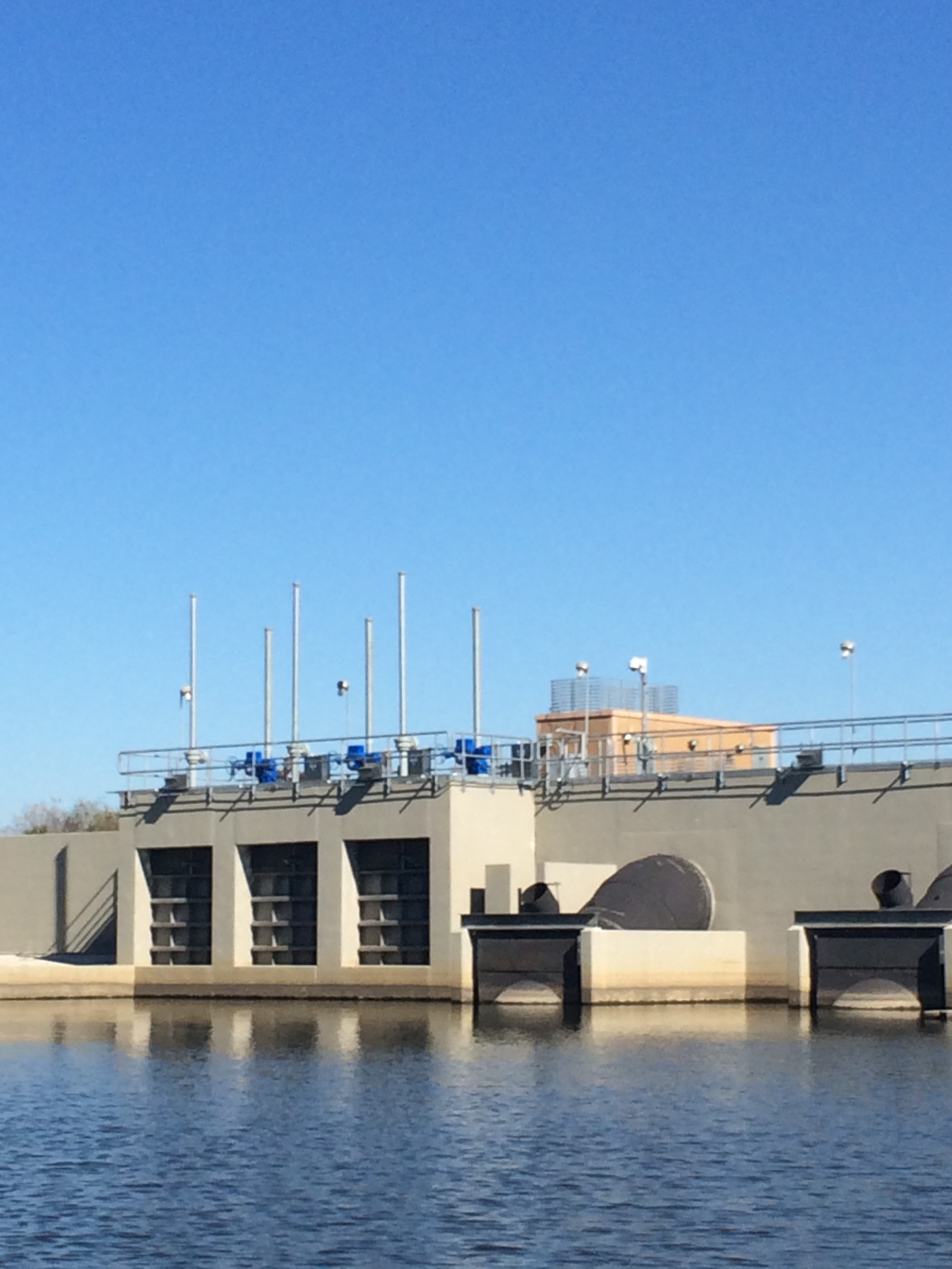
Les déblais provenant du dragage des canaux sont repoussés dans les canaux, au fur et à mesure que les fonds nécessaires à la réalisation des projets sont disponibles, dans le cadre d'opérations de "remblayage". Cela permet de rétablir l'hydrologie normale et de maintenir le marais en bonne santé et moins stressé. Le remblayage des canaux permet d'éliminer la barrière hydrologique que constituent les bancs de déblais de dragage et de combler partiellement les canaux inutilisés depuis longtemps pour la prospection ou la production pétrolières. À l'aide d'équipements lourds, tels que des excavateurs montés sur des chariots amphibies, les anciens bancs de déblais sont poussés dans les canaux. Les arbres sont abattus et l'élévation finale est similaire à celle des marais environnants. Cela permet l'écoulement naturel de l'eau et le mélange et l'équilibre des eaux douces et saumâtres. Les canaux ont été remblayés pour un coût de 12 000 USD/0,5 ha.
Les barrières hydrologiques sont supprimées, l'écoulement de l'eau n'est plus limité, un échange d'eaux douces et salées peut avoir lieu et les sédiments contenus dans l'eau peuvent se déplacer dans le marais, nourrissant le marais et ajoutant à l'accrétion verticale du sol. Les plantes aquatiques submergées se développent à mesure que le fond du canal s'élève.
Facteurs favorables
Les anciens canaux inutilisés doivent être présents dans le paysage. Le financement nécessaire pour pousser les anciens bancs de déblais de dragage doit également être disponible. Une fois que toutes les autorisations nécessaires ont été obtenues, les projets peuvent être mis en œuvre.
Leçon apprise
Cette technique est relativement simple d'un point de vue logistique. Il est essentiel d'obtenir tous les permis nécessaires avant le début des travaux. Il faut également s'assurer que toutes les parties concernées par les terres ont été incluses dans la planification. Aux États-Unis, il y a plusieurs propriétaires/utilisateurs dans certains endroits, comme les parcs nationaux, où les entreprises de combustibles fossiles détiennent les droits d'extraction du sous-sol. Les anciens canaux sont souvent des vestiges de la prospection pétrolière et certaines entreprises ne veulent pas qu'ils soient comblés, bien qu'ils soient souvent restés inutilisés pendant des décennies.
Dans le cas des canaux comblés au PNH Jean Lafitte, les canaux se sont agrandis et élargis depuis qu'ils ont été creusés. Le fait de repousser les bancs de déblais et la végétation dans les canaux ne les rend pas complètement à la terre, mais élève suffisamment le fond de l'eau pour permettre aux plantes aquatiques submergées de prospérer et à l'hydrologie de revenir rapidement à ses niveaux de base. Cet impact améliore la santé des zones humides dans leur ensemble.
Alimentation des marais en couches minces
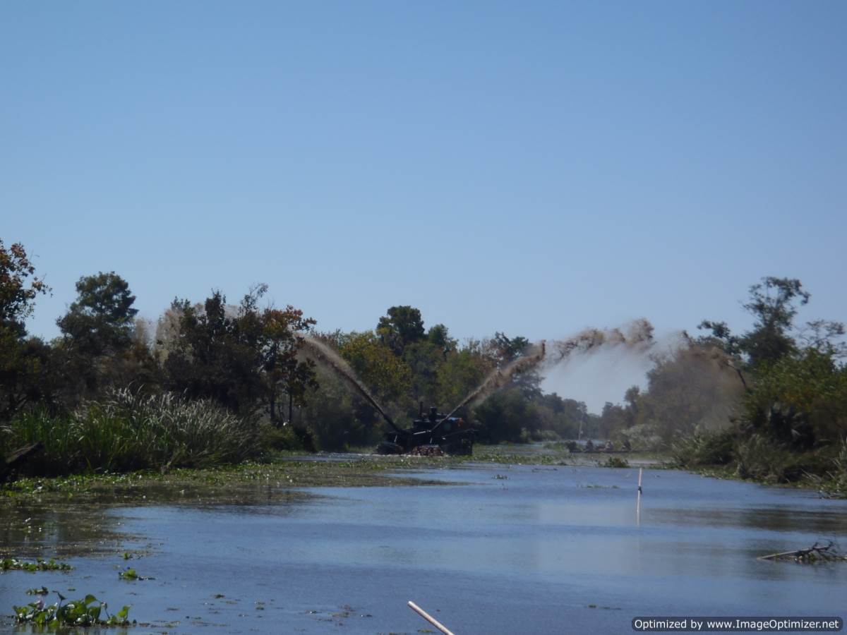
Les matériaux dragués lors des opérations de dragage périodiques sont parfois répandus sur le marais, y compris le marais flottant, dans le cadre d'un effort d'alimentation du marais. Dans la mesure du possible, on utilise des dragues d'épandage. Ces dragues collectent les matériaux, les mélangent à l'eau ambiante et pulvérisent la boue sur la surface du marais. L'épaisseur de la boue appliquée peut varier : elle peut être très légère, ce qui permet de nourrir le marais avec des sédiments frais et des charges nutritives légères, ou être appliquée à la surface du marais à des profondeurs allant jusqu'à 30 cm environ. Des applications plus épaisses seraient souhaitables s'il y a un fort déficit d'élévation verticale dû à des taux élevés d'affaissement du sol.
Facteurs favorables
Le dragage des voies d'eau avoisinantes devra être effectué. Étant donné les distances relativement courtes sur lesquelles la boue peut être pulvérisée, les zones d'application devraient se situer à moins de cinquante (50) mètres de l'opération de dragage. Le financement et les permis devront également être obtenus.
Leçon apprise
L'épandage en couches minces de matériaux de dragage peut être très bénéfique pour le marais. Des applications de plus de 30 cm peuvent enterrer trop profondément une communauté végétale existante, tuant ainsi la végétation et causant peut-être plus de mal que de bien. Il est important d'exercer une surveillance étroite, car les entreprises de dragage appliquent souvent la boue de manière aléatoire, selon leurs désirs, au lieu de l'appliquer là où le restaurateur le souhaiterait.
Utilisation des dérivations contrôlées de cours d'eau pour la restauration
Des dérivations ont été construites le long du fleuve Mississippi en Louisiane pour remplacer en partie la fonction perdue des impulsions périodiques d'eau douce, historiquement délivrées pendant les périodes de hautes eaux, dans les zones humides côtières. Les dérivations sont des structures de contrôle de l'eau qui permettent de réguler les débits du fleuve Mississippi dans les différents bassins du delta. La dérivation de Davis Pond, avec un débit de 300 mètres cubes par seconde, en amont de la Nouvelle-Orléans, libère de l'eau douce dans le bassin de Barataria, ce qui influence fortement les salinités et les charges de sédiments dans la Réserve de Barataria du PNH Jean Lafitte. L'abondance d'eau douce et de nutriments dans la réserve entraîne une forte croissance de la végétation aquatique submergée (SAV).
Facteurs favorables
Les autorités locales et nationales financent ces structures coûteuses. L'accord du public est essentiel, car les modifications de l'hydrologie et de l'écosystème auront un impact sur les utilisateurs, même si la plupart d'entre eux considèrent qu'il s'agit d'une amélioration.
Leçon apprise
Tout le monde n'est pas d'accord pour dire que l'apport d'eau douce est une bonne chose. Les pêcheurs commerciaux craignent que leurs zones de pêche ne changent et qu'ils doivent voyager plus loin et utiliser plus de carburant pour trouver les mêmes espèces que celles qu'ils attrapent actuellement. Des apports excessifs d'eau et de sédiments peuvent également modifier les communautés de plantes flottantes et submergées de manière indésirable. Une surveillance périodique est essentielle pour s'assurer que les dérivations sont gérées et exploitées de manière optimale.
Restauration des îles-barrières pour la réduction des risques de catastrophe
Les îles-barrières sont depuis longtemps considérées comme un moyen de réduire les risques de catastrophe liés aux ondes de tempête. La modélisation montre que les îles-barrières contribuent à l'atténuation des ondes de tempête, mais ne les suppriment pas complètement. Les avantages comprennent la réduction des risques annuels de dommages causés par les ouragans et les tempêtes sur le continent, les avantages annuels en matière de loisirs et les pertes annuelles évitées dans le secteur de la pêche. En replaçant le sable dans la zone littorale, on contribue à long terme au bilan sédimentaire des îles et on permet aux chaînes d'îles de remplacer les sables perdus à un endroit pour assurer la croissance à d'autres. Les sables sont soit transportés par bateau depuis d'autres endroits, soit dragués à partir de sources proches, puis pompés dans la zone dégradée par étapes, ce qui permet une certaine décantation naturelle.
Facteurs favorables
La réalisation de ces projets de restauration nécessite un financement important, généralement de la part du gouvernement fédéral. Les autorisations et les études d'impact sur l'environnement doivent être réalisées afin de garantir l'absence d'effets négatifs non intentionnels.
Leçon apprise
La faune du littoral et de la zone d'éclaboussures sera temporairement déplacée. Les activités des tortues de mer en période de nidification pourraient également être déplacées. Il est essentiel de superviser les entrepreneurs chargés du placement du sable afin de s'assurer que le sable est placé au bon endroit et à la bonne hauteur.
Impacts
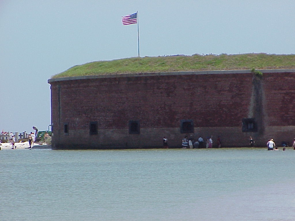
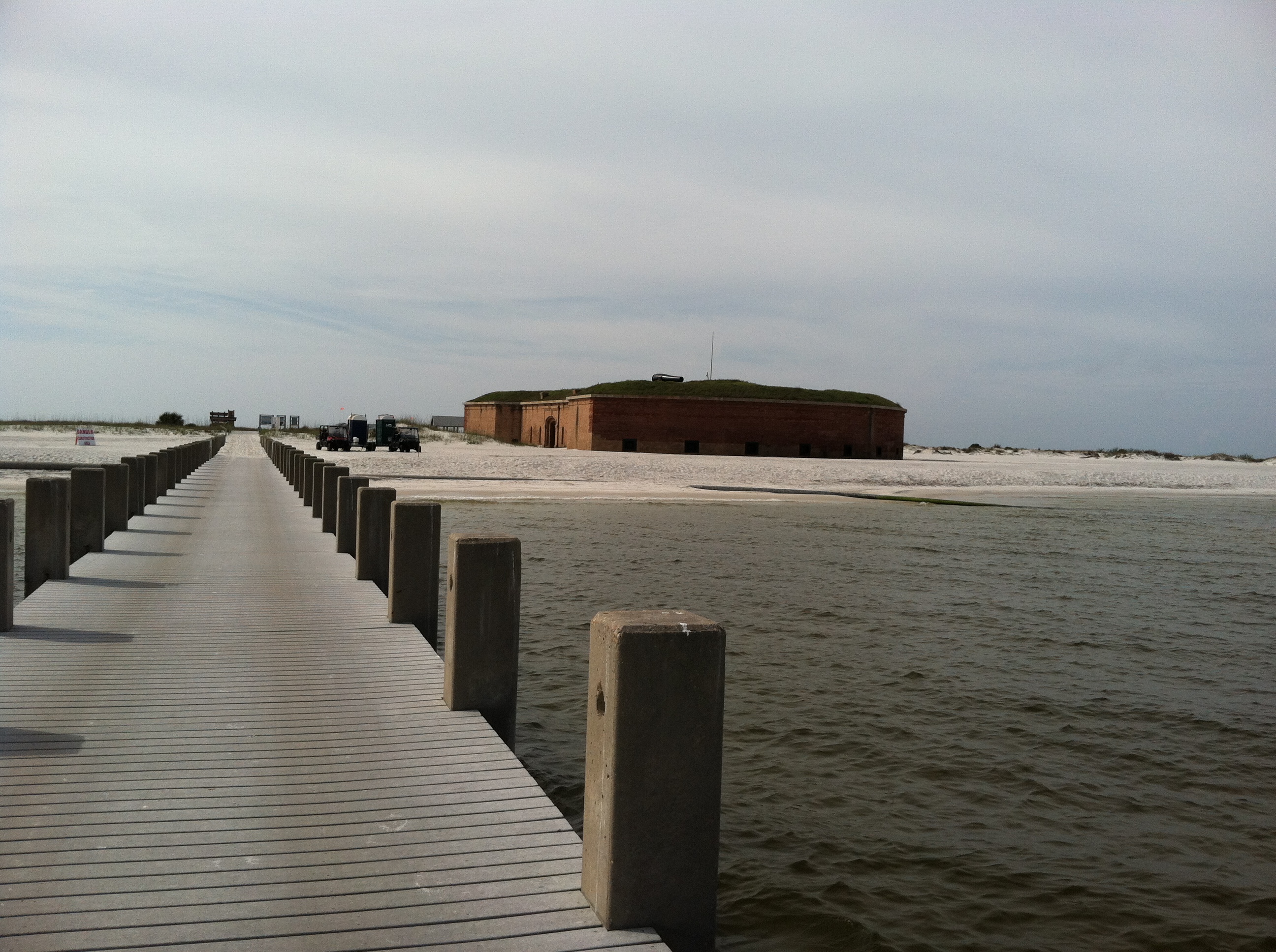
Les zones humides et les îles-barrières permettent de réduire les risques de catastrophe en atténuant les ondes de tempête et l'élévation du niveau de la mer et en protégeant les digues de protection contre les ouragans qui bordent l'agglomération de la Nouvelle-Orléans en Louisiane. La restauration des îles du golfe du Mexique dans le Gulf Islands National Seashore contribue également à la réduction des risques de catastrophe et à l'atténuation des ondes de tempête. Ces écosystèmes servent à protéger les personnes, les habitations, les entreprises et les infrastructures essentielles telles que les routes, les ponts et les voies ferrées. Il a été prouvé que les digues de réduction des risques de catastrophe ont été protégées par les marais lors de récents ouragans. Les marais côtiers ont réduit l'impact des ondes de tempête et de l'élévation du niveau de la mer en étant capables d'absorber la montée des eaux. Les îles-barrières réduisent les ondes de tempête. Dans les zones continentales les plus proches des îles-barrières, les dégâts causés par des tempêtes telles que l'ouragan Katrina ont été moins importants que dans les zones plus exposées. La restauration par le remplacement des sables perdus a permis de protéger des structures telles que Fort Massachusetts sur West Ship Island. Les zones humides et les îles-barrières constituent également un élément essentiel de l'économie touristique locale.
Bénéficiaires
Les habitants et les entreprises des communautés côtières sont les bénéficiaires des projets de restauration.
Histoire
La ville et l'agglomération de La Nouvelle-Orléans, en Louisiane, aux États-Unis, sont divisées par le fleuve Mississippi. Le quartier central des affaires, le quartier français historique et certaines des communautés suburbaines se trouvent à l'est, sur la rive est. Les autres communautés de la zone se trouvent sur la rive ouest. En 2005, l'ouragan Katrina a touché terre juste à l'est de la ville de la Nouvelle-Orléans. Les pertes humaines, principalement dues à la défaillance du système de protection contre les tempêtes, s'élèvent à près de 1 600 personnes dans la seule région métropolitaine de la Nouvelle-Orléans. Ces pertes en vies humaines se sont principalement produites sur la rive est. La rive ouest de la Nouvelle-Orléans n'a pas été inondée. La principale différence réside dans le fait que le système de protection contre les tempêtes des communautés de la rive ouest offre une protection supplémentaire grâce à des écosystèmes de marais et de marécages sains. Des recherches ont montré que les digues dotées d'une protection contre les marais et les marécages n'ont pas cédé lors de l'ouragan Katrina. Plus tard, en 2012, l'ouragan Issac, une tempête de catégorie 2 sur l'échelle de Saffir-Simpson, a également frappé la région métropolitaine de la Nouvelle-Orléans. Sept ans après Katrina, des projets de restauration ont été mis en place dans toute la région de la Nouvelle-Orléans, à l'instar de ce qui a été fait dans le PNHA Jean Lafitte, et aucune digue ne s'est rompue. Des marais restaurés plus sains, des canaux comblés, des marécages restaurés ont fourni une protection suffisante au système de protection contre les tempêtes pour épargner les inondations à toutes ces communautés.