Renforcer la capacité des gestionnaires de parcs à surveiller les impacts sur les espèces en Catalogne, Espagne
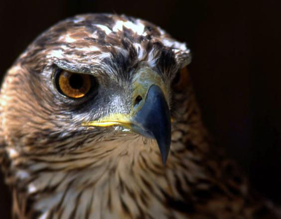
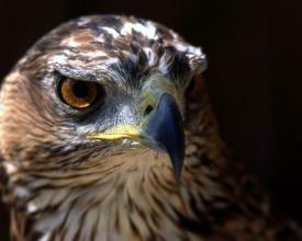
L'aigle de Bonelli(Aquila fasciata) est une espèce phare de la Méditerranée, bien qu'elle soit vulnérable dans plusieurs parties de la région. En Catalogne, le service de la faune du gouvernement a estimé à 85 le nombre de couples reproducteurs, dont un dans le parc naturel de Sant Llorenç del Munt i l'Obac. Les gestionnaires du parc ont dû relever des défis pour comprendre et surveiller le comportement reproducteur de l'espèce et sa relation avec les différentes menaces et pressions à l'intérieur et à l'extérieur du parc.
Tech4Nature Espagne a développé un programme de suivi pour comprendre comment les visiteurs et d'autres facteurs externes affectent le comportement de reproduction et de mobilité de l'aigle. Une architecture technologique utilisant des caméras, des traceurs GPS et le logiciel Axis Station a été mise en place, ainsi que des mesures et des alertes pour garantir une meilleure infrastructure de surveillance et des capacités de prévention. Cette solution peut être reproduite dans d'autres zones protégées, être appliquée à d'autres espèces et même à d'autres phénomènes tels que les incendies de forêt.
Contexte
Défis à relever
Cette solution a permis de relever les principaux défis auxquels sont confrontées les zones protégées et conservées en matière de gestion des espèces et de leurs habitats : le manque d'infrastructures technologiques et de ressources économiques allouées à la surveillance et à la recherche.
La solution a également permis de relever un autre défi, à savoir l'augmentation des capacités de gestion et des compétences du personnel des parcs. La solution et les paramètres mis en œuvre ont été développés en étroite collaboration avec l'équipe de gestion du parc. Par conséquent, l'architecture technologique est adaptée aux ressources humaines disponibles, à la fois en termes de simplicité d'utilisation du logiciel et de temps nécessaire à consacrer au système de surveillance, ce qui garantit son succès à long terme.
Enfin, cette solution permet de relever un autre défi, à savoir le manque de données spatiales sur les principales perturbations subies par certaines espèces menacées (dans ce cas, l'aigle de Bonelli), ce qui est essentiel pour améliorer leur conservation.
Emplacement
Traiter
Résumé du processus
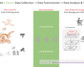
La solution se compose de quatre éléments. La première porte sur la mise en œuvre de l'architecture technologique qui permettra de surveiller et de contrôler les espèces. Pour obtenir les données souhaitées, il est essentiel de s'assurer que l'infrastructure adéquate est en place.
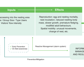
Le deuxième bloc prend l'infrastructure technologique du premier bloc comme base pour la collecte de données et crée une méthodologie et un système de surveillance qui suit le comportement des espèces et des visiteurs du parc, ainsi qu'un système d'alerte précoce pour la détection des risques.
Sur cette base, le troisième bloc implique que le personnel du parc utilise les résultats du système de surveillance pour élargir ses connaissances et prendre des décisions éclairées pour la gestion du territoire et des espèces.
Enfin, le dernier bloc de construction soutient la planification, le lancement, la mise en œuvre, le suivi, l'amélioration et la diffusion de la solution. Cela implique l'établissement d'un partenariat fructueux désireux de maximiser l'impact de l'initiative. Ces quatre éléments sont donc essentiels pour garantir un contrôle adéquat de l'espèce et remédier aux principaux impacts qui l'affectent.
Blocs de construction
Installation de l'infrastructure technologique
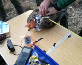
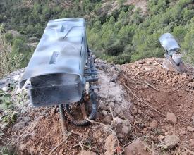
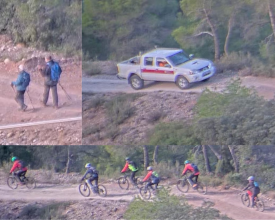
L'infrastructure technologique est composée de deux caméras le long du sentier voisin pour surveiller les flux de visiteurs, et d'une caméra panoramique devant le nid, qui ont été installées en octobre 2022. Les caméras sont alimentées par des panneaux solaires et disposent également de micros intégrés qui détectent les perturbations sonores. Deux émetteurs GPS, installés en décembre 2022, sont utilisés pour suivre le comportement du couple d'aigles. La transmission des données des caméras s'effectue par le biais d'antennes micro-ondes point à point et d'une ligne Internet séparée. Les informations sont stockées sur le NAS et sur le cloud de Huawei. Les unités GPS comprennent une petite plaque d'alimentation solaire, et les données sont transférées par radiofréquence vers le nuage de Move Bank.
Facteurs favorables
Pour assurer la réussite de ce projet, il est essentiel de disposer d'un équipement technique (traceurs GPS et caméras), d'une connexion sans fil pour la transmission des données et d'un système de stockage. La capacité humaine à savoir comment et où installer l'équipement afin d'éviter les perturbations pour les espèces est également essentielle, afin de garantir que le cycle de reproduction de l'espèce ne soit pas affecté.
Leçon apprise
Comme dans de nombreux projets expérimentaux, le programme de suivi a rencontré des difficultés techniques, principalement dues à des problèmes de connectivité et à la nécessité de coordonner différents systèmes et équipes. Les considérations juridico-administratives, telles que l'utilisation des données et les autorisations d'installation, sont également essentielles lors de la mise en œuvre de cet élément constitutif.
En ce qui concerne les traceurs GPS, la programmation des émetteurs en fonction de différentes géozones permet d'optimiser la réception des emplacements et d'améliorer la mise à jour des données pour d'éventuelles demandes d'urgence. En outre, le modèle d'émetteur à double plaque solaire placé sur la femelle s'est avéré plus efficace que le modèle à plaque unique placé sur le mâle pendant les mois de faible ensoleillement.
La caméra du nid doit être installée à une distance suffisante pour éviter les perturbations tout en assurant une bonne résolution d'image. Dans ce cas, le besoin d'un appareil à plus haute résolution a été identifié afin d'effectuer une bonne interprétation du comportement, d'identifier les individus bagués et leurs proies, ainsi que de mettre en œuvre l'automatisation des alarmes.
Système de suivi expérimental
Le système de surveillance expérimental consiste en un ensemble de paramètres permettant de suivre le comportement de l'espèce, les pratiques de mobilité des visiteurs et la détection des risques :
- Emetteurs GPS : ils sont programmés pour la collecte de données et avec un calendrier de téléchargement ; il y a un zonage autour du nid.
- Logiciel AxisStation: Axis Loitering Guard suit les objets en mouvement et déclenche des alertes (par exemple, un utilisateur existe sur le sentier depuis x temps), des alertes sonores et des notifications lorsqu'un seuil est dépassé. Axis Fend Guard détecte les événements d'interaction (par exemple, l'oiseau quitte la piste suivante, deux utilisateurs quittent la piste).
- Alertes en cas de mortalité potentielle, d'expulsion potentielle du territoire, d'absence au nid, d'utilisateurs à proximité du nid et de seuils sonores.
- Autres données relatives à l'utilisation des sentiers par type d'utilisateur et au processus de reproduction de l'aigle de Bonelli.
- Rapports annuels sur la mobilité spatiale des rapaces, rapports semestriels sur les interactions et les événements critiques.
Facteurs favorables
Il est essentiel de pouvoir compter sur un logiciel simple d'utilisation et programmé avec les paramètres souhaités. Il est fondamental de rendre les paramètres aussi pertinents que possible pour les besoins spécifiques de la surveillance, et aussi concis que possible pour que les gestionnaires du parc soient en mesure de faire un suivi approprié et de répondre aux alertes.
Il convient de noter que certaines situations impliquant la faune ne peuvent être contrôlées. Par exemple, dans notre cas, nous avons été confrontés à l'échec de la reproduction du couple d'aigles de Bonelli, ce qui a modifié en partie l'objectif du suivi.
Leçon apprise
Bien que l'utilisation d'un logiciel de gestion des alertes plus sophistiqué basé sur l'intelligence artificielle soit à l'étude, un logiciel simple tel que Axis Station peut suffire pour commencer à développer un programme de surveillance fonctionnel qui notifie les événements à risque critique. Les processus et procédures de gestion des pré-alertes, de collecte et d'analyse des données doivent être périodiquement optimisés sur la base des enseignements tirés au cours du processus.
Renforcement des capacités et prise de décision éclairée pour la surveillance des espèces
La mise en œuvre de l'architecture technique et du programme de surveillance a permis de disposer d'une grande base de données d'informations sur les espèces et leur environnement. La disponibilité des données est essentielle pour que le personnel du parc (gestionnaires, gardes, techniciens, etc.) prenne des décisions en connaissance de cause lorsqu'il s'agit de stratégies de gestion du territoire et des espèces. En outre, la conception locale du programme de suivi et de ses paramètres a augmenté la capacité du personnel du parc non seulement à le gérer, mais aussi à l'améliorer et à l'appliquer éventuellement au suivi d'autres espèces et même d'autres phénomènes.
Facteurs favorables
Il est fondamental d'assurer un processus de co-conception, afin que les techniciens du parc ne soient pas seulement les bénéficiaires et les utilisateurs finaux de la solution, mais qu'ils soient également capables de s'approprier et d'auto-adapter le programme de suivi. À cette fin, un diagnostic initial des capacités du personnel doit être effectué, suivi d'une formation spécifique ciblant les faiblesses qui ont été identifiées.
Leçon apprise
Actuellement, les données des caméras sont stockées dans les caméras elles-mêmes et les techniciens doivent y accéder et les télécharger manuellement. Afin de mettre pleinement en œuvre cette architecture, il est souhaitable d'intégrer un double dispositif de stockage des données utilisant à la fois le stockage de l'appareil et un service en nuage. L'objectif est de compléter cette intégration pour permettre un processus automatique qui réduise le temps alloué au processus de surveillance.
Créer des partenariats intersectoriels
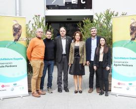
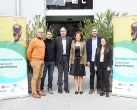
La mise en œuvre de cette solution n'a été possible que grâce à un partenariat intersectoriel unique établi dans le cadre de l'initiative Tech4Nature en Espagne. Ce partenariat était composé d'autorités locales (Diputació de Barcelona), de techniciens, de gardes et de gestionnaires de parcs (Sant Llorenç del Munt i l'Obac), d'experts en conservation de la nature (UICN Med), d'une société informatique (Huawei), de spécialistes du GPS (Parés&Bosch) et de spécialistes de la surveillance par caméra (Miranatura). Le partenariat se développe continuellement et il est prévu que des équipes de recherche et des universités le rejoignent dans un avenir proche, apportant leur expertise et leur expérience.
Facteurs favorables
Pour qu'un partenariat intersectoriel soit couronné de succès, l'étendue de l'implication de chaque partenaire doit être clarifiée dès le départ. L'appropriation locale de la solution est un facteur fondamental pour garantir son succès à long terme.
Leçon apprise
Les partenaires doivent être impliqués dès le début de la solution pour garantir un véritable processus de co-création. Néanmoins, le partenariat doit être ouvert à d'éventuels changements dans sa composition qui peuvent conduire à d'autres progrès et améliorations. L'appropriation locale de la solution est ce qui garantira sa durabilité à long terme.
Impacts
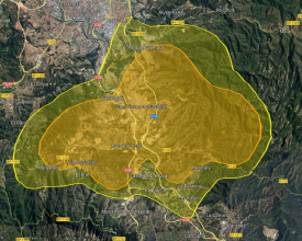
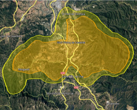
La solution a permis d'obtenir plus de résultats que prévu dans la surveillance de l'écologie de l'aigle de Bonelli. Les traceurs GPS ont enregistré 5 511 positions pour l'aigle mâle, et son domaine vital a été établi à 71 km2. Quant à l'aigle femelle, 21 187 localisations ont été enregistrées, avec un domaine vital de 68 km2. Le programme de surveillance a également révélé que les aigles s'aventurent hors du parc pour chasser, ce qui accroît les menaces. Jusqu'à présent, aucune perturbation notable due aux visiteurs n'a été détectée.
Le système de surveillance détecte les risques d'expulsion ou de mortalité, ce qui améliore la capacité de gestion. Il a également permis de détecter et d'intervenir lors d'événements critiques :
- La femelle a passé 7 heures la tête en bas sur le sol. La technologie a permis d'en établir les causes : une bagarre avec une femelle voisine, probablement due à la dépendance à la densité, contribuant potentiellement à l'échec de la reproduction.
- La mort du mâle. Les localisations GPS ont montré que le mâle était inhabituellement immobile à côté d'une tour de communication. Le corps a été trouvé avant d'être prédaté et l'électrocution a été déterminée comme cause de la mort. Cela a permis d'identifier un point noir pour la survie de l'espèce et de signaler l'incident en vue d'éventuelles mesures d'atténuation.
- Le recrutement d'un autre mâle 17 jours après la mort du mâle précédent. Il a été détecté par la caméra du nid et confirmé par les gardes forestiers.
Bénéficiaires
Gestionnaires de parcs et gardes forestiers impliqués dans le suivi des espèces et la gestion de l'utilisation des terres dans le parc naturel de Sant Llorenç del Munt i l'Obac, en Catalogne (Espagne).
Chercheurs étudiant le comportement et l'évolution de l'aigle de Bonelli.
Objectifs de développement durable
Histoire

Pendant des décennies, un groupe important de scientifiques, de techniciens, de gardes forestiers et d'agents ruraux a suivi un couple d'aigles de Bonelli nichant dans le parc naturel de Sant Llorenç del Munt i l'Obac. L'objectif était de comprendre leur comportement, les zones de chasse et de nidification, le succès de la reproduction, les conditions de l'habitat et les proies.
En tant que technicien chargé de la conservation de la biodiversité dans le parc naturel depuis cinq ans, j'apprécie beaucoup la collaboration avec Tech4Nature. Cette solution représente un pas important vers la réglementation de l'utilisation par le public des zones et des périodes critiques pour ces espèces protégées.
L'initiative répond à un défi majeur dans la gestion du parc : obtenir des informations précises sur la distribution annuelle de ces oiseaux de proie, les activités humaines dans leur zone de nidification et la tolérance des aigles à l'égard de ces activités en fonction de leur intensité, de leur proximité et de la période de l'année.
Les résultats du suivi permettront d'élaborer des réglementations basées sur les données spécifiques de ce couple d'aigles de Bonelli, complétant ainsi les études plus larges menées dans le bassin méditerranéen et suivant le principe de précaution, crucial pour la conservation de la biodiversité.
Ce projet a atteint plusieurs objectifs clés :
- reconnaître et souligner les efforts de professionnels dévoués
- Sensibiliser les parties prenantes (autorités locales, organisations environnementales et habitants des municipalités voisines) grâce à des campagnes de communication.
- souligner l'importance des partenariats public-privé pour assurer la conservation de la biodiversité
- Sensibiliser au risque d'électrocution causé par des lignes électriques mal conçues.
- souligner la nécessité d'une gestion systémique de l'environnement naturel, tant à l'intérieur qu'à l'extérieur des zones protégées.
Sur le plan professionnel, cette initiative m'a permis de me familiariser avec les technologies de suivi, telles que l'image et le GPS, pour :
- Visualiser la présence des aigles et comprendre leur comportement
- Surveiller les alentours du nid et les zones plus larges
- Suivre les mouvements individuels des oiseaux au sein de leur territoire
Par exemple, j'ai appris que ces aigles ont des routines bien définies et qu'ils passent la plupart de leur temps ensemble. Le matin, avant la ponte, ils quittent généralement le perchoir pour se rassembler au nid ou pour repérer les proies, ainsi que pour défendre leur territoire contre les couples voisins.
Daniel Pons, technicien de la conservation et biologiste, parc naturel de Sant Llorenç del Munt i l'Obac.
