

Daniel Pons Julià
Daniel Pons Julià
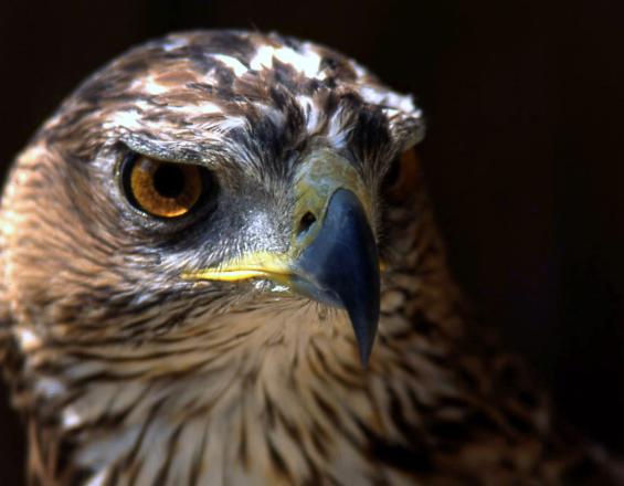
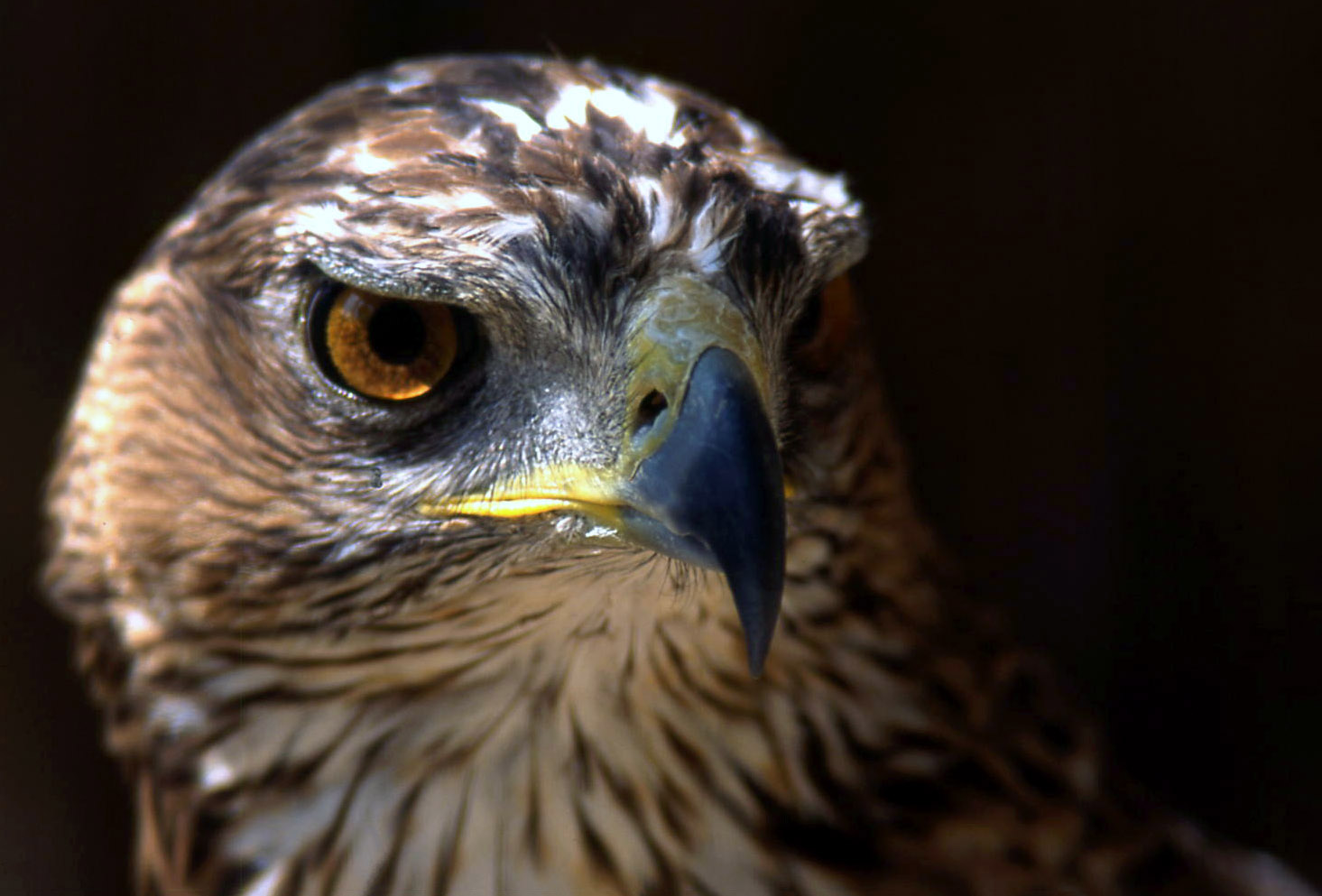
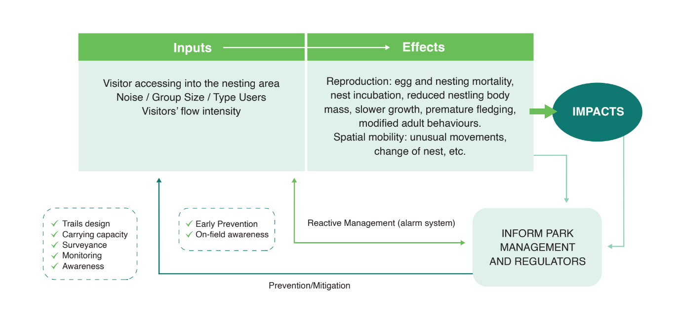
The Bonelli’s eagle (Aquila fasciata) is a flagship species in the Mediterranean, although it is vulnerable in several parts of the region. In Catalonia, the Wildlife Service of the Government has estimated 85 breeding pairs, one of them in Sant Llorenç del Munt i l’Obac Natural Park. Park managers have faced challenges in understanding and monitoring the species' reproductive behaviour and its relation with different threats and pressures within and outside the park.
Tech4Nature Spain developed a monitoring programme to understand how visitors and other external factors affect the eagle’s breeding and mobility behaviour. A technological architecture using cameras, GPS trackers and the Axis Station software was put in place along with metrics and alerts to ensure a better monitoring infrastructure and prevention capabilities. This solution can be replicated in other protected areas, be applied to other species and even other phenomena such as wildfires.
The solution has tackled the main challenges faced by protected and conserved areas when it comes to the management of the species and their habitats: the lack of technological infrastructure and economic resources allocated to monitoring and research.
The solution has also tackled another challenge, which is the increase of the management capacities and skills of the park staff. The implemented solution and parameters have been developed in close collaboration with the park management team. Therefore, the technological architecture is adapted to the available human resources, both in terms of the simplicity to use the software and the time needed to allocate to the monitoring system, ensuring its long-term success.
Finally, this solution tackles another challenge, which is the lack of spatial data about the main disturbances to specific endangered species (in this case the Bonelli’s eagle), which is essential to improve their conservation.
The solution consists of four building blocks. The first one focuses on the implementation of the technological architecture that will allow to monitor and control the species. Ensuring that the correct infrastructure is in place is key to obtain the desirable data.
The second building block takes the technological infrastructure of the first block as a basis for data collection and creates a methodology and monitoring system that tracks the behaviour of the species and park visitors, along with an early warning system for risk detection.
Building on this, the third building block involves park staff using the outcomes of the monitoring system to expand their knowledge and make informed decisions for territory and species management.
Finally, the last building block sustains the correct planning, inception, implementation, monitoring, improvement and dissemination of the solution. This involves the establishment of a successful partnership willing to maximise the initiative’s impact. Therefore, these four building blocks are fundamental to ensuring the proper control of the species and addressing the primary impacts affecting it.
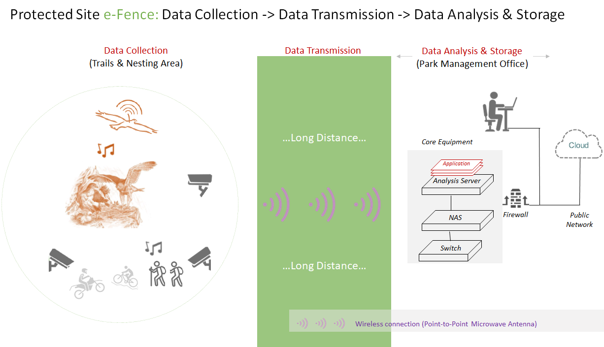
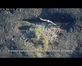
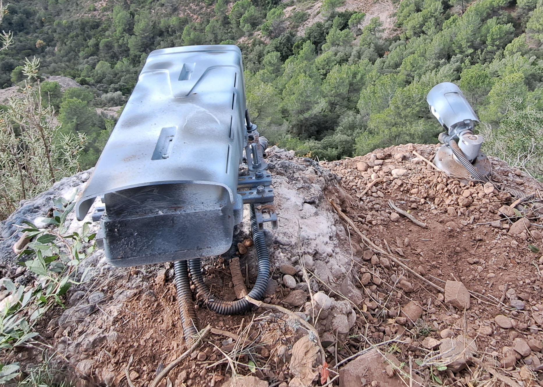
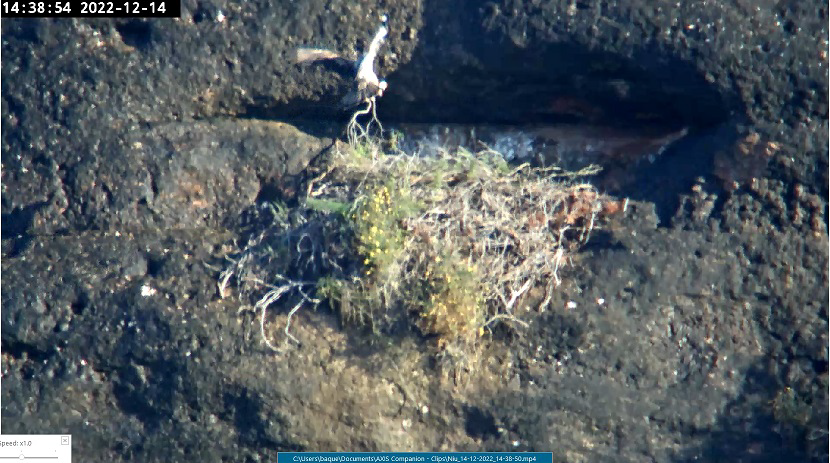
The technological infrastructure is composed of two cameras along the nearby trail to monitor visitor flows, and a panoramic camera in front of the nest, which were installed in October 2022. The cameras are powered by solar panels and also have integrated mics that detect noise disturbances. Two GPS transmitters, installed in December 2022, are used to track the behaviour of for the pair of eagles. Data transmission from the cameras is carried out through point-to-point microwave antennas via a separate Internet line. The information is stored on the NAS and on Huawei’s cloud. The GPS units include a small solar power plate, and the data is transferred via radio frequency to the Move Bank cloud.
To enable the success of this building block, it is essential to count on the technical equipment (GPS trackers and cameras), a wireless connection to allow data transmission, and a storage system. Human capacity to know how and where to install the equipment in order to avoid disturbances to the species is also key, ensuring that the reproduction cycle of the species isn’t affected.
As in many experimental projects, the monitoring programme encountered technical challenges, mainly due to connectivity issues and the need to coordinate various systems and teams. Legal-administrative considerations, such as data use and installation permissions, are also essential when implementing this building block.
Concerning the GPS trackers, the programming of the transmitters according to different geozones makes it possible to optimise the reception of locations and improve the updating of the data for possible emergency inquiries. Besides, the double solar plate transmitter model placed on the female has proven to be more effective than the single plate model placed on the male during the months of less insolation.
The nest camera needs to be installed using and adequate distance to avoid disturbances while ensuring a good image resolution. In this case, the need for a higher-resolution device has been identified in order to make a good interpretation of the behaviour, identify the ringed individuals and their preys, as well as to implement the automation of alarms.
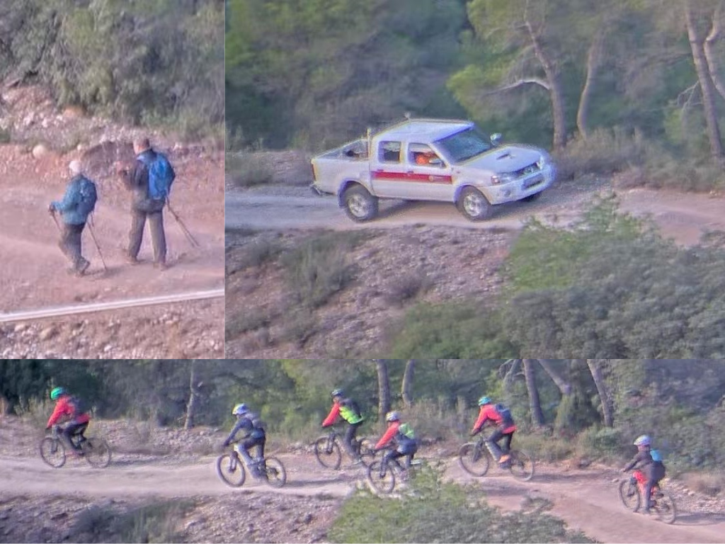
The experimental monitoring system consists of a set of parameters to track the behaviour of the species, visitor mobility practices, and risk detection:
It is essential to count on a simple-to-use software programmed with the desired parameters. It is fundamental to make the parameters as relevant as possible to the specific monitoring needs, and as concise as possible so that park managers are able to do a proper follow-up and respond to any alerts.
It should be noted that certain situations involving wildlife cannot be controlled. For example, in our case, we faced the reproduction failure of the pair of Bonelli's eagles, which partly modified the monitoring objective.
Although the use of a more sophisticated alert management software based on artificial intelligence is being explored, a simple software such as Axis Station can do the trick to start developing a functioning monitoring programme that notifies critical risk events. Processes and procedures for pre-alert management and data collection and analysis need to be periodically optimised based on the lessons learned during the process.
The implementation of the technical architecture and monitoring programme has ensured the availability of a big database of information both of the species and its environment. Data availability is key to ensure that park staff (managers, rangers, technicians, etc.) makes informed decisions when it comes to territory and species management strategies. Besides, the local design of the monitoring programme and the parameters within it, has increased the capacity of the park staff not only to manage it, but also to improve it and eventually apply it to the monitoring of different species and even other phenomena.
It is fundamental to ensure a co-design process, so that park technicians are not only the beneficiaries and end-users of the solution, but are also able to own and self-adapt the monitoring programme. To that end, an initial diagnosis of the capacities of the staff needs to be done, followed by specific training targeting the weaknesses that have been identified.
Currently, camera data is stored within the cameras themselves and technicians have to access and download the data manually. In order to fully implement this architecture, it is desirable to integrate a dual data storage device using both the device’s storage and a cloud service. The goal is to complete this integration to allow for an automatic process that reduces the time allocated to the monitoring process.
The implementation of this solution has only been possible thanks to a unique cross-sectoral partnership established in the framework of the Tech4Nature initiative in Spain. The partnership was composed of local authorities (Diputació de Barcelona), park technicians, rangers and managers (Sant Llorenç del Munt i l’Obac), nature conservation experts (IUCN Med), IT company (Huawei), GPS specialists (Parés&Bosch), and camera monitoring specialists (Miranatura). The partnership is continuously expanding, and it is expected that research teams and universities will join the partnership in the near future, bringing in their expertise and experience.
In order to make a successful cross-sectoral partnership, the scope of involvement of each partner should be clarified from the very beginning. The local ownership of the solution is a fundamental factor to ensure its success in the long run.
Partners need to be engaged from the very beginning of the solution to ensure a true co-creation process. Nonetheless, the partnership needs to be open to eventual changes in its composition that can lead to further progress and improvements. The local ownership of the solution is what will ensure its long-term sustainability.
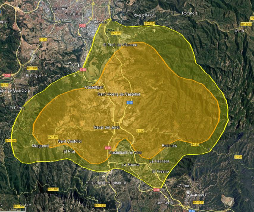
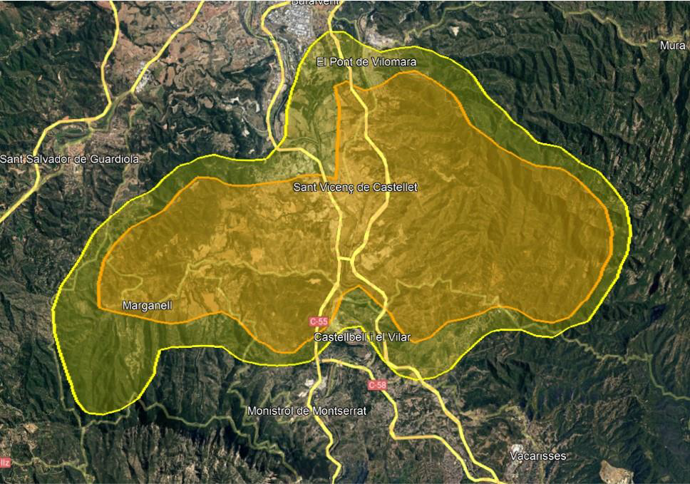
The solution achieved more results than anticipated in monitoring the ecology of Bonelli’s eagle. GPS trackers recorded 5,511 locations for the male eagle, and its vital domain was established at 71 km2. As for the female eagle, 21,187 locations were recorded, with a vital domain of 68 km2. The monitoring programme also revealed that the eagles venture beyond the park for hunting, increasing the threats. So far, no noticeable disturbances by visitors have been detected.
The monitoring system detects risks of expulsion or mortality, improving management capacity. It has also made it possible to detect and intervene during critical events:
Park managers and rangers involved in species monitoring and land-use management in Sant Llorenç del Munt i l’Obac Natural Park, in Catalonia (Spain).
Researchers studying the behaviour and evolution of the Bonelli’s eagle.
For decades, a significant group of scientists, technicians, rangers, and rural agents have monitored a pair of Bonelli's eagles nesting in the Natural Park of Sant Llorenç del Munt i l'Obac. The aim was to understand their behaviour, hunting and nesting areas, reproductive success, habitat conditions, and prey.
In my role as a biodiversity conservation technician in the Natural Park for the past five years, I greatly appreciate the collaboration with Tech4Nature. This solution represents a significant step towards regulating public use in both critical areas and periods for these protected species.
The initiative addresses an outstanding challenge in the park management: obtaining accurate information on the annual distribution of these birds of prey, human activities in their nesting area, and the eagles' tolerance towards these activities according to their intensity, proximity and time of year.
The monitoring results will inform regulations based on the specific data of this pair of Bonelli's eagles, complementing the broader Mediterranean basin studies and following the precautionary principle, crucial for biodiversity conservation.
This project has achieved several key objectives:
Professionally, this initiative has allowed me to become familiar with monitoring technologies, such as images and GPS, to:
For instance, I have learned that these eagles have well-defined routines, spending most of their time together. In the mornings, before egg-laying, they usually fly from the roost to gather at the nest or to scout prey locations, as well as to defend their territory from nearby pairs.
Daniel Pons, Conservation technician and biologist, Sant Llorenç del Munt i l’Obac Natural Park