Nature-Based Solutions in a Guyuan Urban Park to Mitigate Flood Risk and Enhance Community Resilience
Full Solution

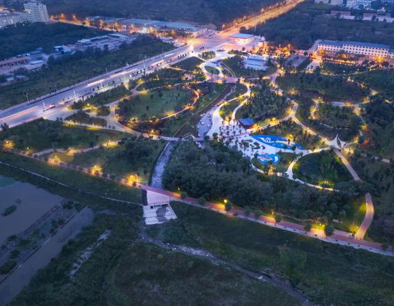
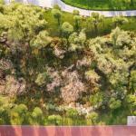
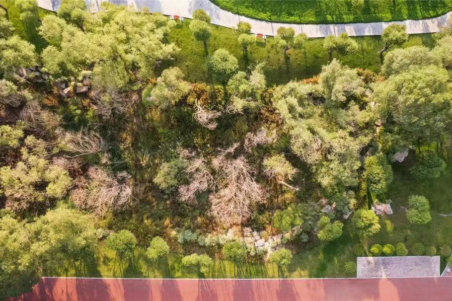
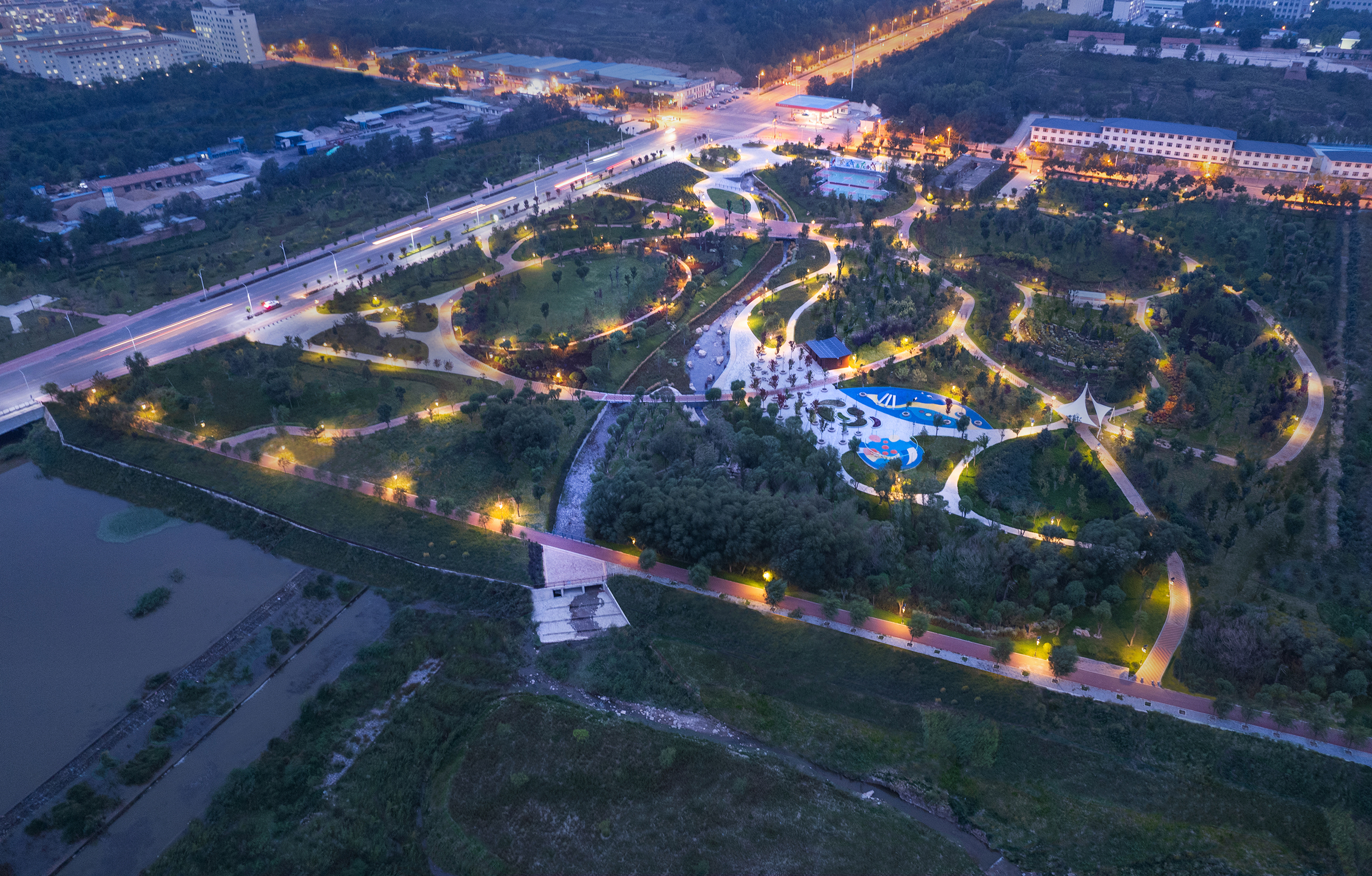
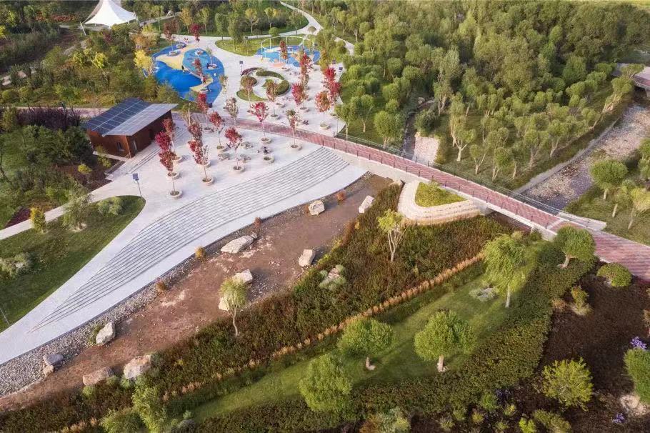
Bird's eye view of Guyuan city park
Beijing Yuren Raineco Technology Co.,Ltd.
Guyuan City in China has faced increasing challenges of flooding and other environmental issues as a result of rapid urbanization. These problems have been exacerbated by extreme rainfall events attributed to climate change. In response, China introduced the Sponge City Initiative in 2014 to mitigate the adverse impacts.
As part of this initiative, a Sponge City Park was designed and built in Guyuan City along the Qingshui River. The park integrated various considerations, including urban flood mitigation, protection of riparian areas, stormwater retention, and the provision of recreational spaces.
With the construction of this stream-themed park, the once open space has transformed into a local attraction, allowing residents to have direct access to water bodies and enjoy the beauty of nature. Additionally, the park plays a crucial role in enhancing urban resilience and adapting to climate change city-wide, aligning with the broader objectives of the Sponge City Initiative.
Last update: 31 Jul 2023
1508 Views
Photo and video gallery


Context
Challenges addressed
The project faces three significant challenges:
1: Drainage and flooding issues: The frequency of river flooding has escalated due to factors such as increased impervious surfaces, inadequate consideration of hydrologic and hydraulic aspects, erosion of waterways, ineffective floodplain management regulations, and the degradation of riparian zones caused by urbanization.
2: Insufficient open space: The project site is situated in a highly developed region of Guyuan City with a scarcity of open spaces. Despite the presence of numerous large communities in the area, the availability of local parks and recreational areas is inadequate, failing to meet the needs of the population.
3: Biodiversity and landscape quality: The rapid pace of urbanization and the presence of aging grey infrastructure have led to a decline in biodiversity. There is a pressing need for improved landscaping to enhance the aesthetic appeal and ecological diversity of the area.
Location
Guyuan city, Ningxia province, China
East Asia
Process
Summary of the process
The project design and implementation process is a comprehensive advancement, in which every element interacts with each other. All building blocks are essential in achieving multiple goals on a solid common base of investigation and flood mapping. Beyond that, all experts in stormwater management, hydronic modeling, landscape design, and ecosystem preservation are all involved in this project with mutually agreed NbS and Sponge City concepts in mind.

Building Blocks
Conduct good site investigation and flood modeling
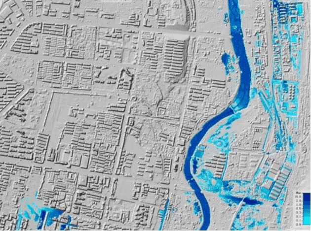
During the initial phase of the project, a comprehensive urban flood risk map was created using GIS and HEC-RAS. This map encompasses both the river and the expansive Guyuan metropolitan area, spanning over 150 square kilometers. The model effectively captures crucial data points like flood velocity, inundation areas, duration, and other vital information, laying a strong foundation for informed decision-making and effective flood mitigation strategies.
Enabling factors
Thanks to the valuable support from the local government and survey department, we were able to obtain high-definition raster data to accurately depict the site’s topography. With a resolution of 0.5m, which surpasses the standards of typical projects, this detailed topographic information greatly benefits all phases of the project, including design and implementation.
Lesson learned
The visualization of modeling results plays a crucial role in enhancing the understanding of flooding issues, particularly for clients. This clear visualization becomes a pivotal factor in obtaining approval for necessary mitigation measures.
Increase the flood mitigation capacity and resiliency


The design approach for the flood canal seems well-thought-out. Diverting water through a weir into two pathways based on rainfall intensity allows for adaptability during different flood conditions.
Below the 5-year flooding level, the water is directed along a branch line to a wetland area, serving as a means for natural purification and infiltration of the water.
For higher flood levels, the canal incorporates an overtopping mechanism at the diversion weir, diverting excess water to the river via a flood channel, for up to a 50-year return period.
Consideration of various flood levels (5-year, 30-year, and 50-year) is important for erosion control measures. Different design strategies, such as impervious concretion base for the 5-year flood, retaining walls along the slope for the 30-year flood, and pervious surface measures above that level due to low erosion risk, help meet the requirements of each flood level and velocity.
Overall, the design of the flood canal appears to account for ecological concerns, varying flood conditions, and the management of sedimentation and erosion.
Enabling factors
1- The completion of flood modeling during the early stages has proven advantageous for the flood canal design.
2- The design of the flood canal received support from a diverse team of experts, including hydrology and hydraulics (H&H) engineers, geotechnical specialists, and landscape architects. The successful implementation of integrated solutions would not have been possible without effective teamwork and collaboration.
Lesson learned
Coordinating different departments and designers are very important through this comprehensive design, to make sure the design meets the demands.
Preserve wetland and reduce the impact of urban development


Wetlands (willow ponds) have is a unique and poetic riverside landscape in the semi-arid Loess Plateau. Recognizing the importance of preserving this distinctive habitat and native flora and fauna along the Qingshui River, the willow ponds were kept with water supported from the Qingshui River.
This conservation effort becomes increasingly important as the existing landscape along the River continues to disappear. By using the existing drainage route as the main line for the flood canal, the impact of development is minimized. This approach reduces the need for soil displacement and lowers the risk of soil collapse, striking a balance between flood control and environmental preservation.
Furthermore, the design incorporates a soft grass area in the side slope of the canal as much as possible. This choice aims to enhance the aesthetic appeal and livability of the canal area. Additionally, the bottom of the canal is kept permeable, to improve the overall quality of the canal as a living space.
By carefully considering these design elements, the project seeks to create a harmonious and sustainable flood canal system that not only manages water flow but also preserves and enhances the unique landscape of the semi-arid Loess Plateau.
Enabling factors
1- With the increasing emphasis on the environment and growing awareness of ecological principles, the ecological design of flood canals is gaining greater acceptance among clients and the general public.
2- The open space available at the site allows for the design of various dimensions for different sections of the flood canal. Additionally, as the building or urban facility is situated at a considerable distance from the canal, it becomes easier for the government client to implement initial experimental details.
Lesson learned
The characteristics of the site play a critical role in determining the approach to mitigate the environmental impacts of man-made facilities. The unique attributes of a site are the primary factors considered when deciding how best to minimize the negative effects on the environment.
Improve water access and maximize social benefits


The design and implementation of the flood canal take into consideration different levels of water.
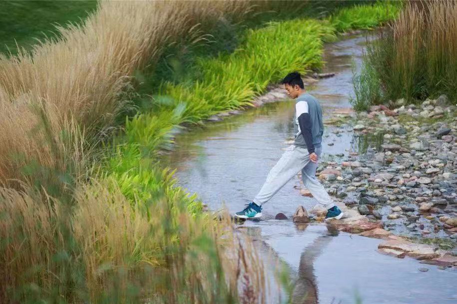
During periods of relatively low water levels (below the 5-yr level), the canal resembles a natural stream. A small flow of water runs through gravel and stones, passes over a weir, scatters in shallow areas, and eventually disappears among wetland plants. This scenic stream continues even on non-rainy days through the use of stored rainwater.
At the 30-year level, the canal serves as a boundary for different types of plants. Above this level, groups of trees and shrubs are planted, while below it, various species of Miscanthus are cultivated. These plants are well-suited to fluctuating water levels and protect against the force of large flood flows.
At the 50-year level, all pathways in the park are elevated above the flood level, ensuring that they remain accessible and cannot be submerged. Along the canal, various amenities are strategically placed to cater to the well-being, comfort, and enjoyment of the citizens. This includes gym facilities, a basketball court, a playground, and shaded seating areas.
Overall, the flood canal area is designed to provide a pleasurable experience for visitors, offering a sense of tranquility, recreational opportunities, and a connection with nature.
Enabling factors
Flood engineers and landscape architects understand that design encompasses much more than mere decoration. They collaborate to create functional and aesthetically pleasing spaces that consider both the practical aspects of flood control and the overall visual and experiential qualities of the environment.
Lesson learned
Studying nature is indeed a valuable approach when creating landscapes. Drawing inspiration from natural ecosystems can help landscape architects design spaces that are harmonious with the surrounding environment and promote ecological balance. We found Nature-based Solutions and Sponge City are both very useful in the design.
Impacts
1: The park effectively mitigates flood risk in the floodplain area by offering natural detention and floodwater storage within and along the river.
2: Drainage from surrounding areas is significantly enhanced, ensuring better management of off-site run-ons.
3: The park contributes to the preservation and enhancement of biodiversity by improving the natural habitat and conserving diverse ecological patterns.
4: In addition to flood mitigation measures, the park serves as a valuable open space for residents, providing both local water access and ample recreational areas for the community to enjoy.
Beneficiaries
Citizens: better living conditions;
City: economic losses due to floods are reduced; retention volume credits and water quality improvements are counted towards the Sponge CIty goals set by the central government.
Sustainable Development Goals
SDG 6 – Clean water and sanitation
SDG 11 – Sustainable cities and communities
SDG 13 – Climate action