

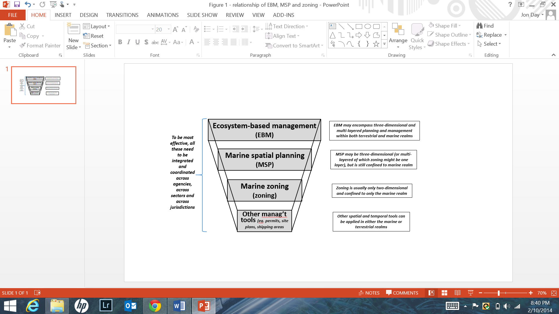
Coordinated multi-layered management for implementation of MSP across the GBR
Solution complète

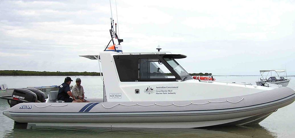
The GBR Field Management program involves staff of the Queensland National Parks Service working in a coordinated way in the federal Marine Park, the adjoining State Marine Park and on National Park islands.
GBRMPA
This solution addresses achieving effective MPA management, especially with resource limitations, in the Great Barrier Reef Marine Park, Australia; it is primarily aimed at MPA managers, but also others who need to understand MPA management.
Dernière modification 30 Sep 2020
7204 Vues
Galerie de photos et de vidéos


Contexte
Challenges addressed
Achieving effective MPA management, especially with resource limitations.
Managing an MPA is usually a continuous, adaptive and participatory process, with the aim to achieve a desired set of objectives. To be effective, a management system should be coordinated across agencies, regularly reviewed and able to respond to changes in the MPA, to users and to management inadequacies. Sharing tasks across partners is one way that managers can be more effective.
Emplacement
Great Barrier Reef, Queensland, Australia
Oceania
Traiter
Summary of the process
Collectively these building blocks outline how to achieve effective MPA management in a complex area like the GBR, especially when resources are limited. To be effective, management should be coordinated and shared across agencies, regularly reviewed and able to respond to changes in the MPA, to users and to management inadequacies.
Building block 1 outlines the range of multi-layered management ‘tools’ (spatial and temporal) used by the Australian and Queensland governments across the entire GBR. Many of these management approaches are complementary, operating irrespective of the jurisdictional boundaries.
BB2 outlines a broad and comprehensive ecosystem-based management approach addressing issues relevant for effective marine conservation within both the terrestrial and the marine realms.
BB3 outlines some of the complexities of managing major assets (e.g. vessels) for field management and explains how sharing assets can still provide effective field management.
Three further aspects for implementing effective management are also discussed: identifying MPA boundaries in the field (BB4); using technological aids to locate marine boundaries (BB5); and the importance of integrating compliance activities across the GBR (BB6).
Building Blocks
Multi-layered management ‘tools’ (spatial and temporal)
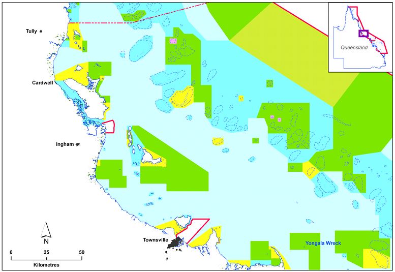
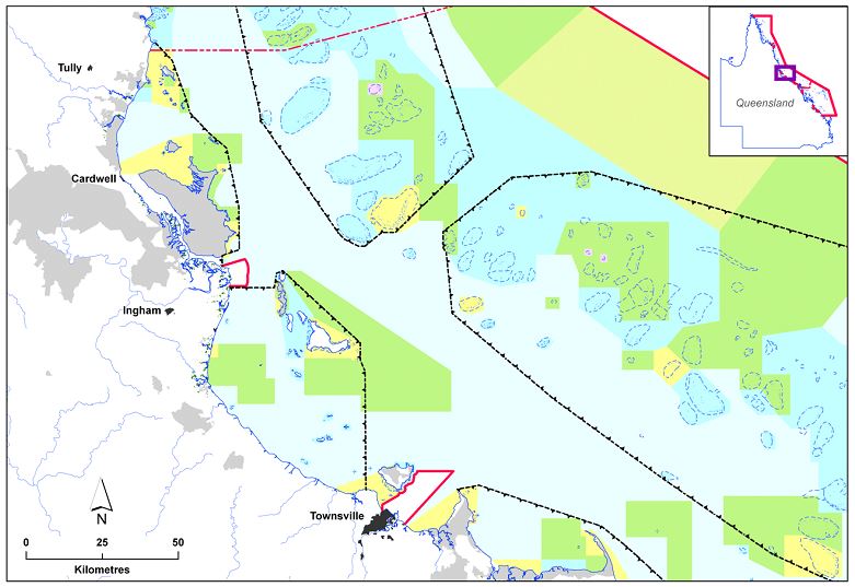
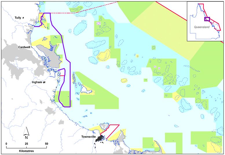
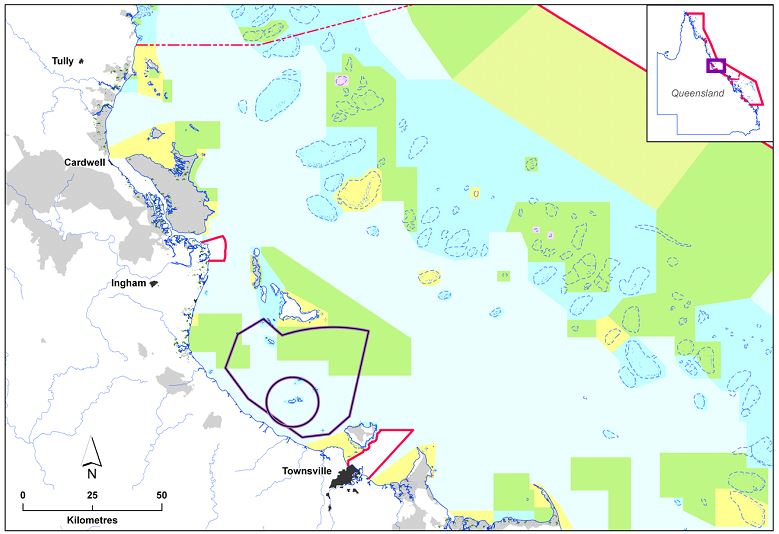
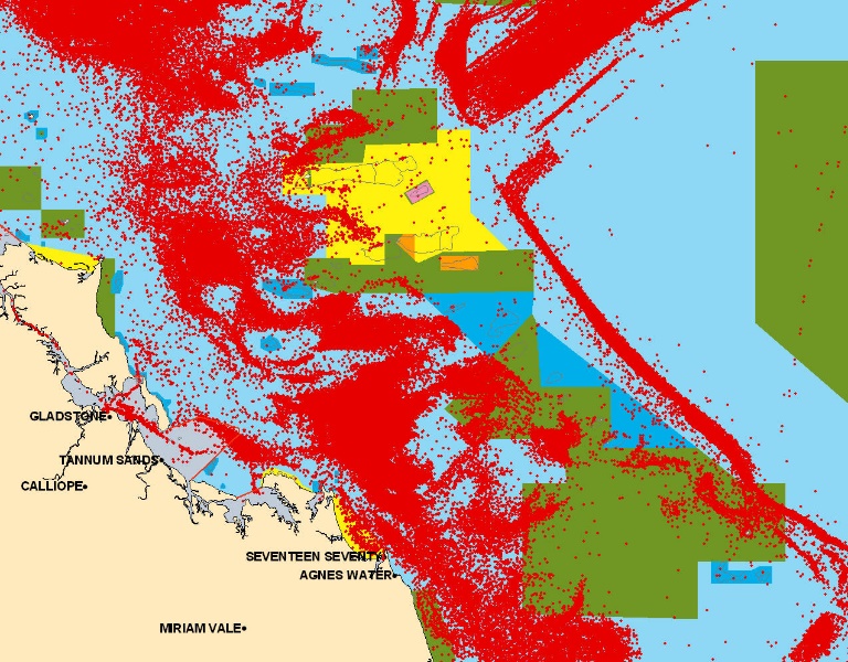
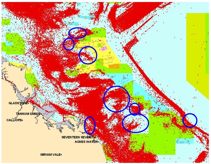
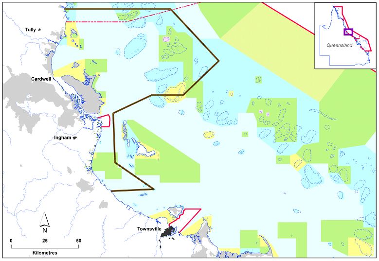
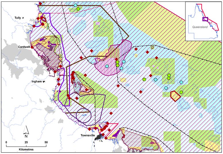
Zoning is only one of many spatial tools used in the Great Barrier Reef. Other spatial layers are depicted in the maps below, showing the same area of the GBR with differing layers overlying the zoning.
A range of multi-dimensional management tools (spatial, non-spatial and temporal) are applied, some of which are part of the statutory GBR Zoning Plan, while others are in other statutory documents. Non-spatial management includes bag limits or size limits for fishing, or a wide range of permits; temporal management includes seasonal closures at key fish spawning times or temporary closures for short-term activities like military training.
So rather than a single GBR management plan, a comprehensive three-dimensional Management system exists, comprising federal agency plans, State agency plans and other plans (e.g. fisheries management, ports, etc). Today this full suite of management tools comprises a comprehensive management framework, integrated and coordinated across agencies and jurisdictions. However, not every aspect of spatial management is shown in the publicly available zoning maps.
Permits (often tied to specific zones or locations within zones) allow a detailed level of site management not possible by zoning alone.
Enabling factors
The Intergovernmental Agreement (the IGA, developed in 1979 but updated in various iterations, i.e. in 2009 and 2015), provides the basis for governments to work cooperatively to manage the GBR using multi-layered management tools.
Other parts of the GBR legislation provide the statutory ‘head of power’ to enable the various management provisions to be applied in the GBR and to have force in law (see also the Blue Solution titled the Sound Legislative/Governance Framework for the GBR)
Lesson learned
• If all these management layers were to exist in a single two-dimensional zoning plan, it would be extremely complex and confusing; however, the publicly available zoning maps show only those management layers that are important for the majority of recreational users.
• The State of Queensland ‘mirrored’ the federal zoning in the majority of the adjoining State waters which means there is complementary zoning for virtually all the State and Federal waters across the entire GBR from high water mark out to a maximum distance of 250 km offshore
• Other complementary management approaches, both spatial and temporal, operate across these jurisdictional boundaries. They have been developed with differing levels of government and with various industries, stakeholders or community groups, and are designed to provide more effective and integrated protection of the entire GBR and thereby increase the resilience of the GBR to cope with escalating pressures.
Ecosystem based management: thinking outside the (marine) box
Many issues facing MPAs cannot be effectively addressed by managing the marine realm alone; e.g:
• water quality – most water quality issues arise on land
• coastal developments, e.g. ports – most are outside the jurisdictional control of an MPA
• increasing population growth and recreation – marine management does little to curtail growth or reduce some consequential impacts
• climate change – management may build resilience but climate change is a global issue
The GBR Marine Park is confined to waters seaward of low water mark so does not include tidal lands/tidal waters; key coastal areas e.g. ports and ‘internal waters’ of Queensland are also excluded (another Blue Solution outlines complementary zoning, irrespective of which jurisdiction applies).
An integrated management approach with other agencies extends the management influence outside the Marine Park so that the islands, tidal areas and many activities in the catchments are effectively addressed. For example, the mapping of coastal ecosystems, the identification of key areas within catchments, and working with farmers to minimise their impacts on water quality, are specifically aimed at addressing the land-sea interface and the adjoining coastal lands and waters.
Enabling factors
• The GBR legislation [s. 66 (2)(e)] also has provisions to take a broad ecosystem-approach, allowing regulatory controls on specific activities outside the jurisdictional area (e.g. specific Regulations controlling aquaculture up to 5 km inland to address the potential adverse impact of aquaculture discharges on GBR water quality).
• Cross-jurisdictional agreements (see Resources) have also assisted the achievement of this broader ecosystem approach.
Lesson learned
• Management of the marine realm alone is unlikely to result in effective marine conservation; additional efforts must also be made in parallel e.g. influencing others to better manage the adjoining coastal waters and catchments.
• A comprehensive ecosystem-based management (EBM) approach encourages ‘thinking outside the box’ (i.e. think differently, and from a new perspective) and can encompass multi-layered management and planning within the terrestrial and the marine realms, which are both relevant for effective marine conservation.
• Such management approaches (e.g. addressing water quality) are best undertaken in partnerships with other agencies, local governments and industries in these adjoining areas.
• Many of the current initiatives undertaken by GBRMPA and other agencies are specifically aimed at addressing the land-sea interface and the adjoining coastal lands and waters.
Sharing assets & responsibility for better field management
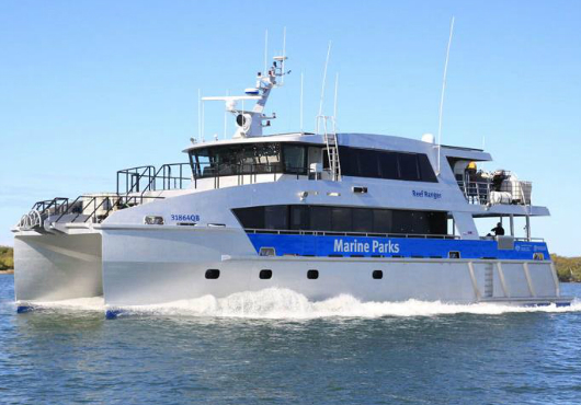
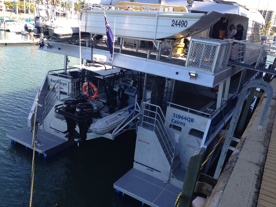
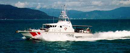
An obvious preference of most MPA managers is to have a fleet of reliable, safe, fit for-purpose vessels, which are well maintained and operational. However, sometimes vessel patrols or some marine management tasks are more appropriately shared (e.g. with other governmental agencies or by chartering a vessel from the private sector).
The operation and ongoing maintenance of specialised management vessels can pose significant challenges, especially if there are insufficient staff in the agency with the necessary technical capacity, or if the operating funds for ongoing regular operations are limited. Determining whether to purchase expensive assets (e.g. specialised fast patrol vessels for enforcement or a stable working vessel to install facilities such as moorings or no-anchoring markers) should consider the objective of providing the required level of service and its frequency of likely use in the most cost-effective manner.
MPA management may also be enhanced by sharing responsibility and information as explained in the Blue Solution on Shared Governance in the GBR. Management may also involve sharing other physical assets than just boats; e.g. shared assets may include operational bases, offices, vehicles and even aircraft.
Enabling factors
The Great Barrier Reef Intergovernmental Agreement provides the framework for the federal and State (Queensland) governments to work together for the long-term management of the GBR.
GBR staff develop an Annual Business Plan to allocate a budget for purchasing and operating assets; that plan then becomes the first year in a Three Year Rolling Program Plan which is reviewed and updated each year to project expected costs over the next 3 years.
Lesson learned
• Experience shows before purchasing a major asset like a specialised vessel there is a need to assess the staff’s capacity to handle the asset throughout its ‘whole life cycle’ (this includes more than just operating the vessel, and should extend from the design, construction and commissioning of the vessel, to its operation, maintenance and modification, and ultimately its replacement/decommissioning).
• If your MPA requires specialized equipment like an expensive patrol vessel, consider asking your management partners to share resources (e.g. ‘cross-decking’ ie. having staff from multiple agencies operating together on the one patrol vessel or sharing vessels between agencies).
• A prioritised asset replacement schedule is part of a regularly reviewed business strategy (e.g. outboards replaced every 4-5 years; larger vessels replaced every 10-15 years).
• Access to big vessels, planes/helicopters is nice, but such resources are not essential for an effective compliance program.
Identifying MPA boundaries in the field
The boundaries of an MPA (or zones within an MPA) should be identifiable while on the water. Traditionally, inshore MPA boundaries were referenced to some obvious natural feature or by using a distance from a feature like the shoreline.
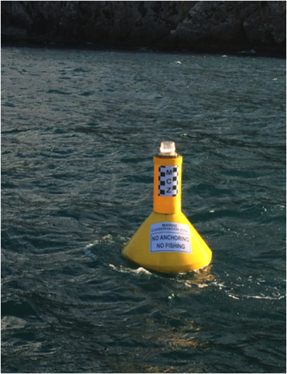
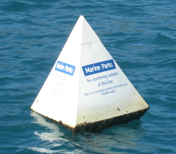
In some instances, physical demarcation of marine boundaries has occurred using fixed markers on the land or floating marker buoys, but there are significant costs to install and maintain such infrastructure.
For deepwater, open-ocean conditions or for large MPAs the placement of marker buoys is extremely difficult, if not impossible, and the cost is prohibitive. For these reasons, MPA managers delineate such offshore boundaries using GPS coordinates (see Resources for Coordinate-based zone boundaries).
Experience has shown that submerged features (e.g. depth contours, reefs, banks, shipwrecks, etc) may be hard to identify so should not be used for marine boundaries.
Florida Keys National Marine Sanctuary has considerable experience with installing offshore infrastructure for marine boundaries; FKNMS staff have installed >100 yellow boundary buoys marking marine zones; over 120 boundary buoys and/or signs marking Wildlife Management Areas, and are responsible for > 500 mooring buoys.
Enabling factors
Best Practice approaches for boundary development are available (see Resources) to develop effective and accurate marine boundaries and definitions; these can help reduce boundary misunderstandings and possibly litigation.
Lesson learned
• Mooring buoys can be excellent management tools, but concerns exist they can negatively impact marine resources by attracting and concentrating boaters, divers or fishermen to one location. Education programs must therefore accompany any mooring buoy program, with monitoring to assess any impacts.
• Reference to an identifiable geographic feature can help clarify a boundary location; however, the geographic coordinates will also help enforceability.
• An issue with MPA boundaries includes fishers ‘fishing the line’ with resulting edge-effects (i.e. MPA edges being more heavily impacted).
• If only a single land-based marker is used, the boundary may be seen to differ depending on which line of sight is viewed.
• Haste and inexperience can lead to poor MPA boundaries. Always ground-truth boundaries for accuracy and completeness.
• Shorelines may be ambulatory (i.e erode or accrete) so boundaries may be a problem to enforce if they move or are difficult to define.
Technological aids to assist marine management
Effective management in the marine realm can be greatly assisted by various technological aids; examples include:
• Global Positioning System (GPS) - a satellite navigation system accessible to anyone with a GPS receiver (including most cell phones). Provided there is unobstructed access to four or more GPS satellites, a GPS will provide three-dimensional position, velocity and time anywhere on Earth.
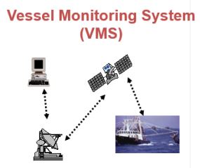
• Vessel Monitoring System (VMS) - an electronic tracking system used by regulatory agencies to monitor the activities of commercial fishing vessels. VMS can play important roles in fisheries management, including the prevention of illegal fishing and protecting the marine environment. VMS requires a GPS on the vessel and communication between the vessel and shore, usually via satellite. It has wider applications (e.g. collision avoidance) and may be used to monitor vessels up to 200 nm from the coast of most countries.
• Automatic Identification System (AIS) - a radio broadcasting system enabling AIS equipped ships and shore stations to identify and locate ship’s positions, course and speed. Vessel traffic services (VTS) uses AIS to monitor vessels in ports, busy waterways and inshore waters, primarily for safety and efficiency.
Enabling factors
• A GPS may be portable, relatively low cost, generally reliable, rarely influenced by weather and fairly accurate. Differential GPS facilities, however, do provide greater accuracy for the marine enforcement.
• GPS satellites are regularly updated by the various operating governments.
• The cost to access VMS data varies according to the functionality of the system; the greater the functionality, the more expensive the equipment and data links.
Lesson learned
1. MPA managers should seek to augment their field capacity by utilising such technological aids as GPS and/or VMS, particularly as such aids can help to capture and accurately locate observations, heighten intelligence gathering and compliance, and assist in the efficient deployment of vessels based patrols.
2. While a GPS unit may be useful for enforcement in an MPA, a GPS being used in the offshore marine environment needs to be routinely ground-truthed against a known calibrated fixture to ensure accuracy.
3. Sometimes GPS signals are not accurate (interference in the marine realm includes extreme atmospheric conditions and geomagnetic storms). However if differential GPS facilities are available using a network of radio beacons, they provide greater accuracy.
4. A GPS can fail (e.g. if battery powered), or users can, at any given time, be denied access to the system (i.e. satellites shut down), so always carry a backup map and compass.
Integrated compliance activities in the GBR
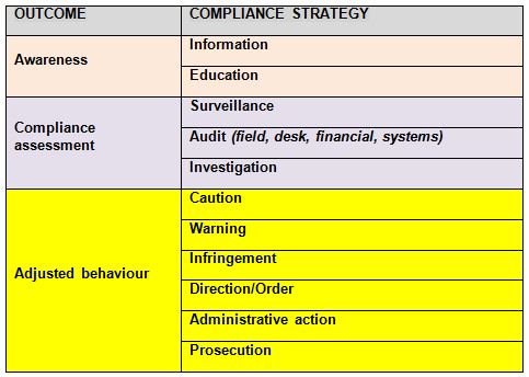
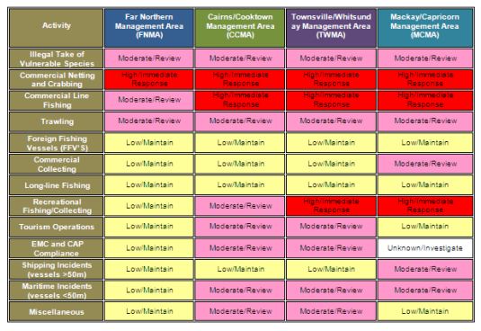
Integrated compliance is a key approach contributing to effective management of the GBR. A number of compliance strategies are utilise to achieve compliance management, comprising a much wider range of strategies than just surveillance or enforcement (see Table 1 below).
Today the GBR’s compliance approach is recognised as being of a world standard. It is implemented by a joint Field Management Compliance Unit (FMCU) comprising trained and competent officers of both the Australian and Queensland governments working closely together. The FMCU has a central role coordinating the deployment of all available compliance resources across the GBR.
The delivery of field activities occurs through a number of key partner agencies including the Queensland Parks and Wildlife Service, the Queensland Boating and Fisheries Patrol, the Queensland Police Service and Australia’s Border Protection Command (BPC). The planning of patrols is based upon intelligence-derived information and delivers maximum detection as well as a deterrence effect.
BPC is the principal provider of aerial operations delivering targeted aerial surveillance. BPC crews are trained by FMCU in the detection of marine park offences and subsequent evidence collection.
Enabling factors
The key factors for overall compliance success in the GBR include:
• Having annual and operational compliance plans aligned with the agency’s strategic objectives and priorities.
• Having comprehensive operating manuals and guidelines underpinned by approved Commonwealth Standards.
• Effective management of information/intelligence (including comprehensive analysis and threat/risk assessment).
• A close working relationship with prosecutors, including the provision of comprehensive briefs.
Lesson learned
- Enforcement and prosecution are not always the preferred choice, and other more appropriate compliance strategies (e.g. education, caution, warning letter or an infringement notice) may be used depending upon the threat, human behaviour and the environmental impact. The objective is to achieve informed self-regulation by the majority of users, allowing limited resources to be focussed on the highest impact, non-compliant users.
- Good intelligence/information can be a key for good compliance.
- Impact statements are supplied when court action is taken; these assist judges to understand the actual or potential harm that an unlawful activity can cause (e.g. illegal fishing can equate to serious environmental harm), and lead to more appropriate penalties being imposed by the judiciary.
- The level of fines currently applied in the GBR is not a deterrent for many fishery offenders; increased use is being made of the ‘Three strikes and you’re out’ approach for repeat-offenders.
Impacts
There are many benefits of sharing responsibility for management across a range of governmental agencies, industries and key partners, especially if an MPA is the size and complexity of the Great Barrier Reef (see Blue Solution - Sound legislative governance framework, esp cross-jurisdictional agreements (BB1), complementary legislation (BB2) and partnerships with key sectors (BB6).
Similarly, working effectively to ensure a high level of coordination between agencies, as well as undertaking compliance planning and enforcement across the MPA, may appear difficult and costly, but the advantages have been shown to be well-worth the effort required. This may include the coordination of intelligence and information gathered from a range of sources over time which can lead to more effective management and enforcement.
Having all users understand the locations of MPA and zone boundaries is also worth the effort. Not all methods to mark boundaries need to be expensive but they do need to be readily available and easy to interpret.
There can be many benefits of effectively using technology to assist with field management, monitoring and enforcement. While such technology may not be cheap, long-term benefity are usually woth the expense
Beneficiaries
Primarily aimed at Great Barrier Reef Marine Park managers, but also others who need to understand MPA management.
Story
Various tools have evolved since the late 1970s to address the fact that management of the large and complex GBR is shared between the Australian Government and the State (Queensland) Government. There are 13 different federal and State government agencies directly involved in preparing, implementing and evaluating various management plans, strategies, programs and initiatives.
A formal Intergovernmental Agreement ensures responsibility is shared by the various federal and State agencies. In addition, key industries and user groups also play important roles by assisting with some of the management challenges.
The GBR is so complex that, rather than a single management plan, it has a comprehensive management system comprising a wide range of marine spatial plans and other management tools.
The comprehensive Zoning Plan is one of the key management tools and is a critical component in helping to manage the multiple uses in the GBR. However, other spatial and temporal management tools and strategies are also used, each with a legislative basis in either Federal or Queensland legislation; including:
• Plans of management for specific areas requiring detailed management provisions, e.g. limiting numbers or applying approved policies
• Site plans and special management areas for specific high use areas or where special local arrangements are required
• Other spatial restrictions, such as designated shipping lanes, Defence Training Areas, species-specific protection Areas
• Other plans regulating use which may or may not be spatial and/or temporal – e.g. fishery management plans, species recovery plans and formal agreements with Traditional Owners
GBR protection and management relies on collaborative efforts built upon partnerships between government agencies, Traditional Owners, stakeholders and community members, with activities both on the water and in the catchment.
Field management is only one aspect of the overall management of the GBR. Field management is also a shared responsibility, coordinated by a specific group within GBRMPA comprising officers of the federal and State agencies. Sharing responsibility, resources and information are key management approaches. For example, a single report of an activity or incident may seem of little consequence but coordinating a wide range of information and intelligence across agencies and over time is likely to show patterns and high-use periods that assist with more effective management and enforcement.


