Applying ecosystem-based disaster risk reduction (Eco-DRR) in Integrated Water Resource Management (IWRM) in the Lukaya Basin, DRC
Full Solution
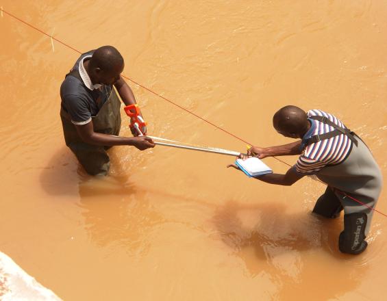
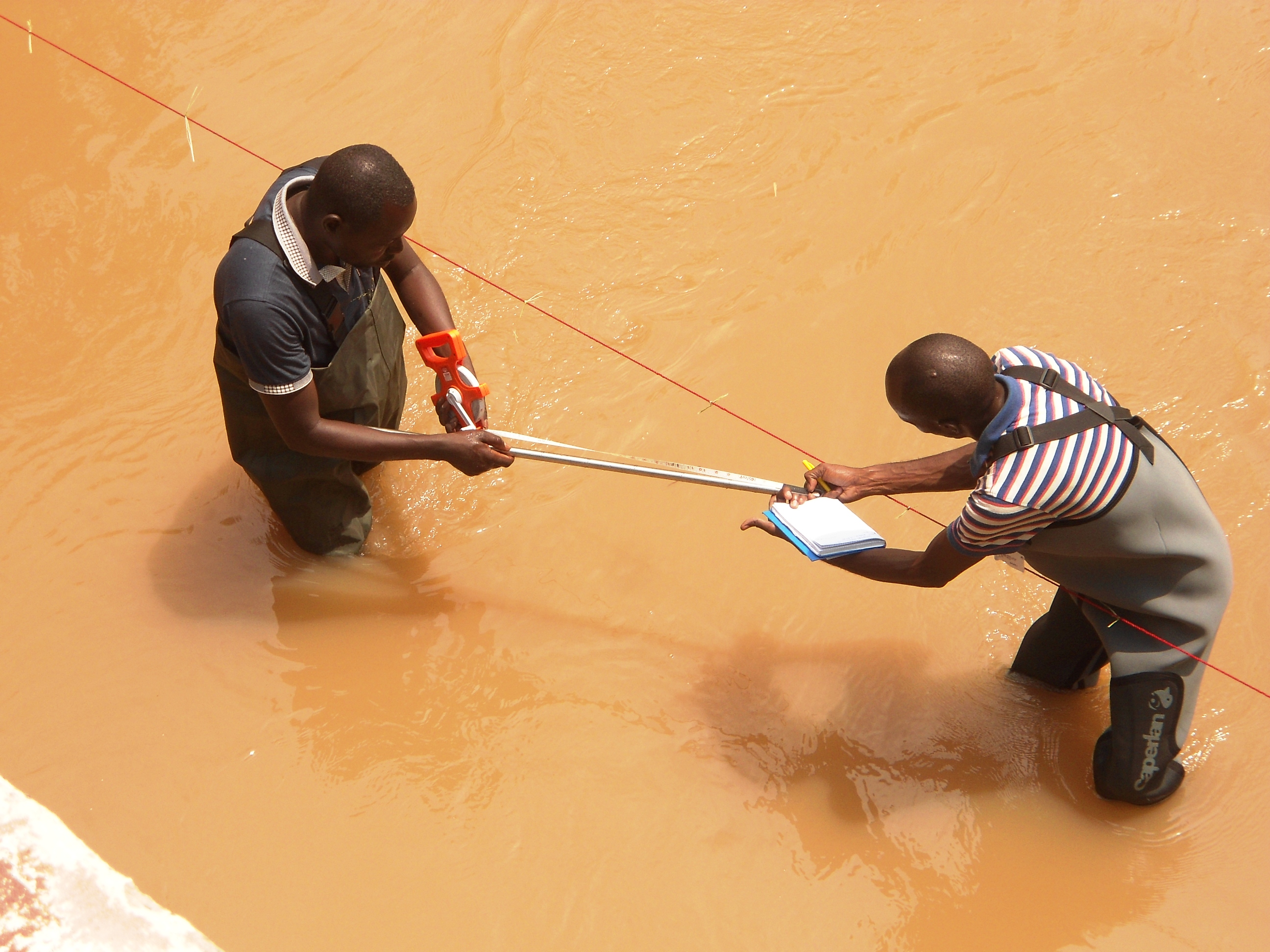
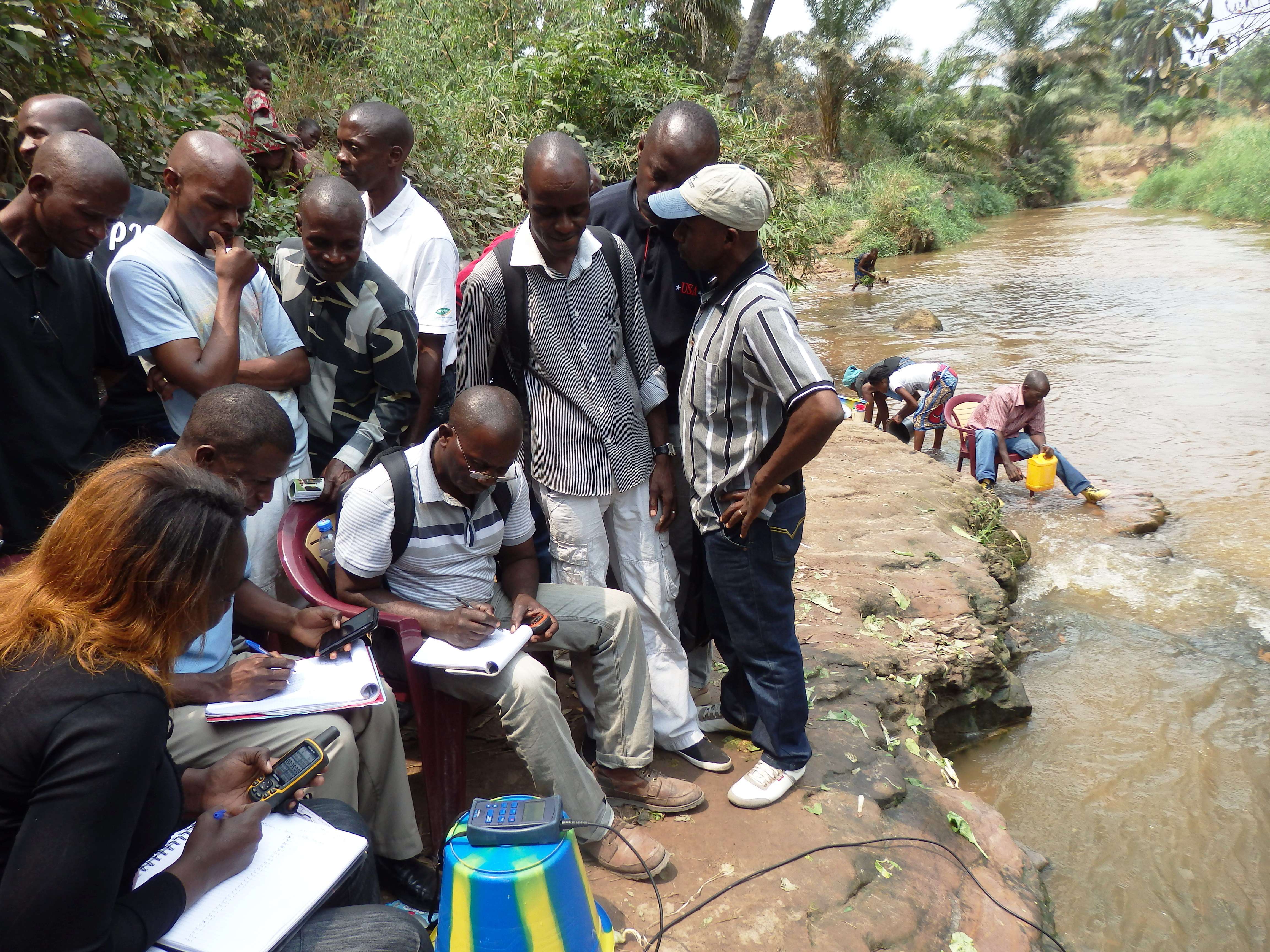
Measuring river flow
UNEP
The project targeted disaster and climate risk reduction as an integral part of an Integrated Water Resource Management (IWRM) process conjunctly taking place in DRC. Pilot ecosystem-based measures aimed to reduce soil/gulley erosion and flood risk in two sites (upstream and downstream) in the Lukaya Basin, while improving livelihoods and income. Capacity was developed locally and nationally on ecosystem-based measures and national advocacy on EbA/Eco-DRR was supported through IWRM.
The project took an Eco-DRR approach addressing hazards and vulnerability to reduce disaster risk. However, the project activities also addressed climate change adaptation through working with climate change impacts and people's vulnerability to change through the ecosystem-based measures involved in IWRM. Thus these measures can be seen as both Eco-DRR and EbA, while the implementation framework was Eco-DRR.
Last update: 30 Sep 2025
9434 Views
Photo and video gallery
Context
Challenges addressed
Water resource management is a challenge in part due to unplanned and uncoordinated land use. Rapid urbanization, slash-and-burn agriculture, quarrying, charcoal production and horticulture have resulted in deforestation and degradation of the land and river water quality. Excessive erosion has created gullies, landslides and increases flood risk, which has become a major problem due to increasing rain, and this also increases sediment pollution in the water.
Location
Kinshasa, Democratic Republic of Congo
West and Central Africa
Process
Summary of the process
Mainstreaming Eco-DRR/EbA in the development of an IWRM Action Plan (building block 1) is the underlying goal of the project. Field activities such as agroforestry and reforestation (building block 2) and gully and soil erosion control (building block 3) provide demonstration of ecosystem-based measures and their benefits for inclusion in (building block 1). Capacity building (building block 4) and national advocacy (building block 5) support long-term sustainability of the IWRM and ecosystem-based measures for disaster risk reduction and climate change adaptation.
Building Blocks
Mainstreaming Eco-DRR/EbA in the development of an IWRM Action Plan
In order to establish a risk-informed and sustainable water resource management framework for the Lukaya basin, ecosystem-based measures are mainstreamed into an Integrated Water Resource Management (IWRM) Action Plan. The Association of the Users of the Lukaya River Basin (AUBR/L) developed the plan with support from UNEP and an international expert and is responsible for its implementation.
The Plan outlines a series of priority actions under four main pillars: water, environment, land use planning and governance. An integral component of the Action Plan is promoting sustainable ecosystem management approaches within the overarching framework of IWRM.
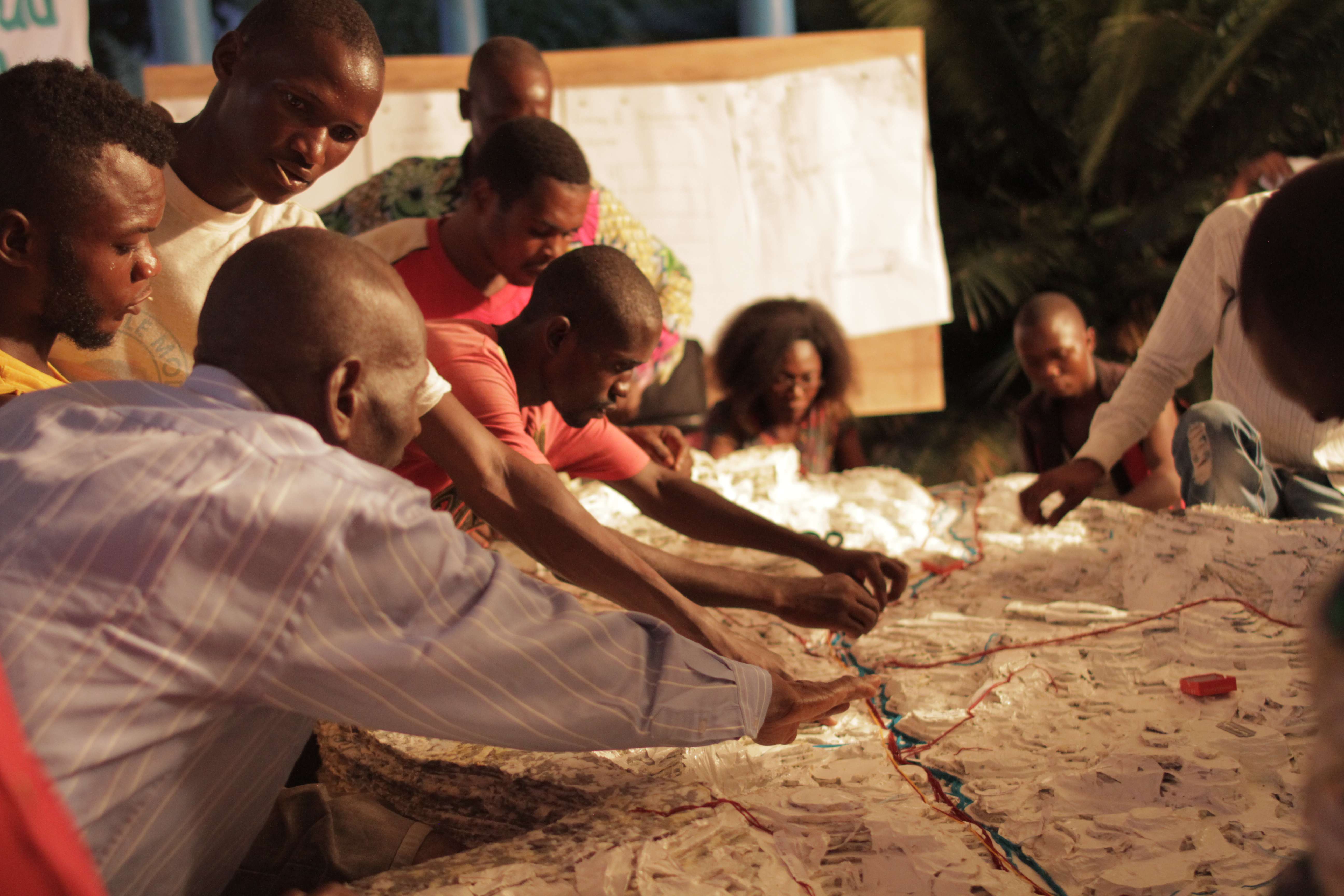
Development of the IWRM Action Plan emphasized the importance of linking upstream and downstream communities and strengthening their knowledge of the geographic and socio-economic conditions within their shared river basin. 3D participatory mapping was used to map hazards, land use types, natural resources and identify major environmental problems and areas at risk in the basin, through a multi-stakeholder, participatory approach.
Furthermore soil erosion and hydro-meteorological monitoring was put in place to allow for flood risk modelling. This would establish baselines and provide data to inform IWRM planning.
Enabling factors
The Eco-DRR project was implemented in conjunction with an UNDA-funded IWRM project in the same area.
3D participatory mapping is an excellent tool because it facilitates the integration of local
spatial knowledge with topographic data through the participation of many stakeholders and the use of geographic information systems.
A key ingredient of successfully promoting Eco-DRR through IWRM in DRC was the sustained participation of local river users, through the AUBR/L.
Lesson learned
The process of IWRM planning was intensive and took almost a year for the first draft to be produced.
The community-based approach (through AUBR/L) is appropriate because of the weak presence of central technical administration at the local level in post-conflict DRC. Having an existing water management institution was fortunate and enabled bringing together key stakeholders from both upstream and downstream and enhancing collaborative relationships. Obtaining buy-in was crucial for the development of the plan and also for activities, such as installing monitoring systems on land.
Several multi-stakeholder workshops and awareness raising were undertaken for the process. As a result, participants gained appreciation of the basin as a shared landscape and identified common priorities for sustainable watershed management, which also contributes to climate and disaster resilience.
Agroforestry and reforestation
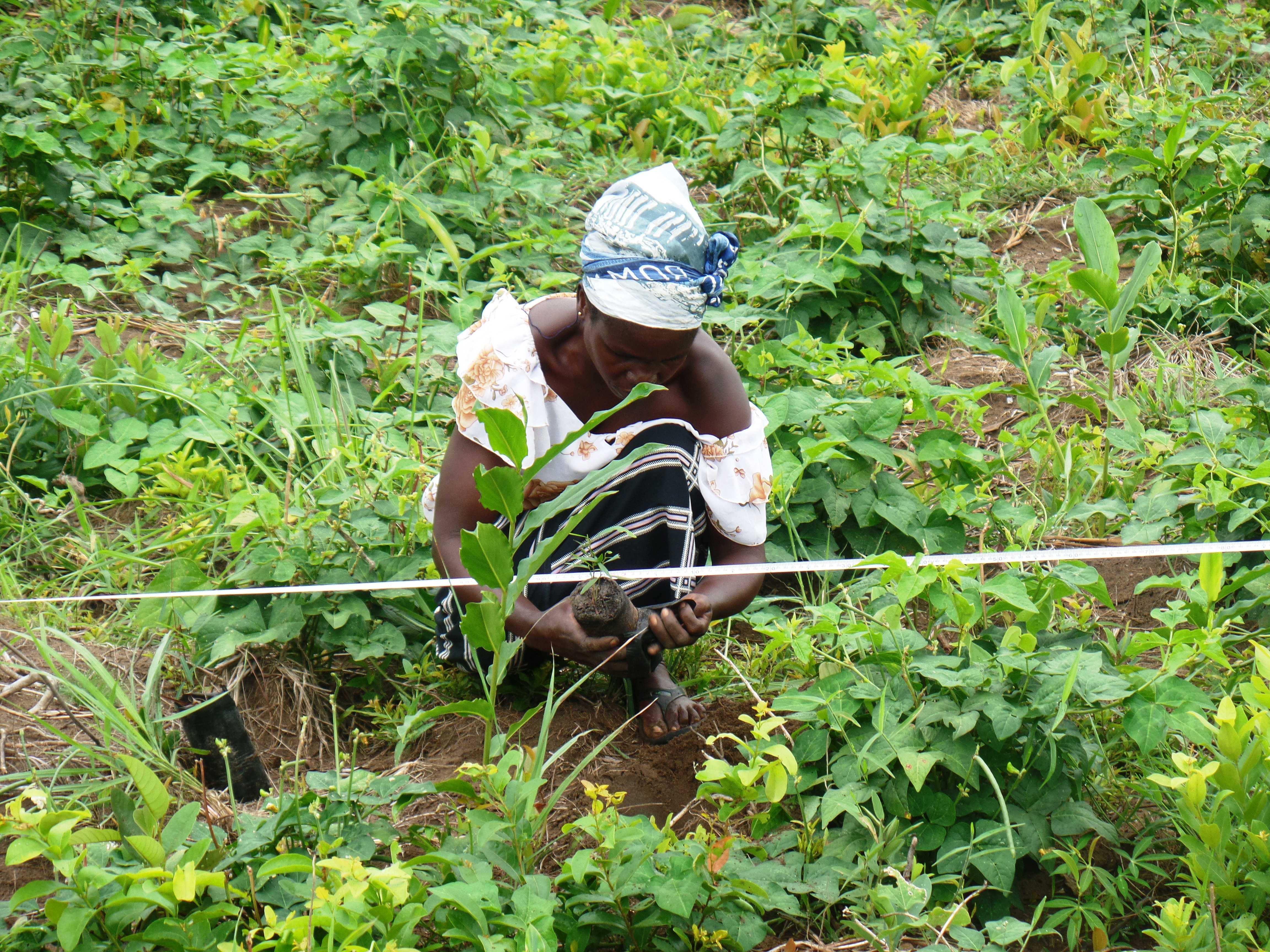
Reforestation and revegetation was undertaken on degraded slopes and around a water treatment site to reduce erosion and flood risk. To provide seedlings for reforestation and agroforestry, community nurseries were set up.
Community-based agroforestry was established on 15ha to provide additional livelihood support to 20 households. It is based on an 8year rotational cycle of crop production and forestry (over 8 parcels, one added each year), which allows for the sustainable management of land and the reduction of soil erosion. Three types of plants are cultivated within a given parcel, namely acacia, cassava and cowpeas, which provide complementary benefits. Bee-keeping also is undertaken. The produce from all this increases income annually for all households, who manage it together. The households, the landowner and the association who have an agreement, whereby 50% of yields go to the farmers, 25% to the association and 25% to the landowner.
Expected income from 1ha, year 1: 3,000USD from production of 100 bags of charcoal from stumps + 6,250USD from harvest of 2,500kg of cowpeas; year 2: 9,615USD from 6,410kg of cassava; year 3-7: 7,000USD from 1,000L of honey; year 8: 35,000USD from 1,750 bags of charcoal produced from mature acacia trees.
Enabling factors
The valuation method 'Integrated Valuation of Environmental Services and Tradeoffs' (InVest) was used to determine field intervention sites by modelling soil erosion potential under different management options. The relatively low data requirements of the InVest model and the fact that it takes into account both the geophysical and ecological characteristics of the area in measuring soil erosion potential make the InVest model highly suitable for EbA/Eco-DRR planning and for data-poor countries.
Lesson learned
Delivering multiple benefits and providing tangible evidence thereof is important for community uptake. Prior to the project, charcoal production and slash and burn agriculture were the main activities. The farmers were unfamiliar with agroforestry and believed the land chosen for the project unsuitable for agriculture.
The overall success was evident by the strong community up-take of the interventions, guided by experienced local partners, and the high survival rate (98%) of the agroforestry trees planted.
However, because of the fact that these were demonstration sites, members of the community not chosen and thus not accessing benefits were unhappy. In one case, fire was deliberately set to destroy a reforestation site. Thus in future, it is important to be mindful of local sensitivities and ensuring that project benefits are shared as broadly as possible, in order to minimize conflict between resource users. It also highlights the limitations of pilot projects.
Gully and soil erosion control
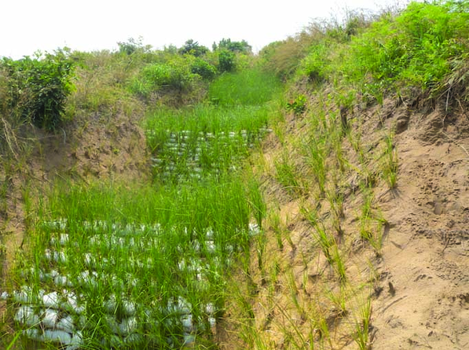
Reducing gully erosion was important to reduce siltation of springs and streams in low lying areas and destruction of infrastructure. In order to treat and arrest the formation of gullies, the project implemented a bioengineering technique using vetiver, a grass known for its deep roots that can effectively control soil erosion. In this method, soil-filled bags are compacted in gullies to arrest progression of gullies. Vetiver are planted in the top soil-filled bags (filled with fertile soil). The bags will normally deteriorate and breakdown under the sun, but the roots of vetiver keep the soil in place.
River banks were also stabilised with vetiver grass after removing uneven projections and smoothing the slope. Vetiver nurseries were set up to supply the two working areas (near the water treatment plant and near Kinshasa).
Enabling factors
A local charity near Kinshasa, where limited land is available for community projects, provided space for a vetiver nursery.
Lesson learned
The use of vetiver for gully and soil erosion control was also very successful, because local residents immediately perceived the protection value provided by the vetiver, especially when sites are located near their homes, schools or public roads. Prior to the project, communities in the basin did not know about the effectiveness of vetiver grass as an erosion control measure. Now neighbouring communities have shown great interest in replicating the bioengineering methodology.
Capacity building
As this was DRC’s first experience in applying both the Eco-DRR, as well as IWRM approach, it was critically important to progressively develop and strengthen capacities over time, which involved:
- Awareness-raising;
- training and workshops;
- Hands-on learning activities in the field demonstration sites;
- Field visits and study tours both in the country and in the region.
There was a total of 71 trainings and workshops. These covered general meetings (inception and presentation); national awareness raising workshops on Eco-DRR and IWRM; workshops related to IWRM, the role of Eco-DRR in IWRM and action planning; trainings on hydro-meteorological monitoring, soil erosion monitoring and flood risk modelling; training on agroforestry and value chain production; and trainings on soil loss monitoring and bioengineering to reduce soil erosion.
Enabling factors
The project emphasized the importance of linking the local group AUBR/L with the relevant National Government ministries and other partners, whose capacity was also built so that the work is sustainable over time.
The project also created new partnerships, which facilitated study tours in the country and in the region.
Lesson learned
A major portion of capacity building took place in the field, as part of “learning-by-doing” through implementation of the field interventions. While these were intended to support field interventions, they were also designed to establish locally-managed systems that would be long lasting. Therefore, trainings were added also according to needs identified during the implementation of the project. For example, it was identified that capacity needed to be established also on how to sell produce from agroforestry (not just on how to implement agroforestry) and on bushfire management after a fire destroyed a reforestation site.
Supporting national advocacy on ecosystem-based measures
To support the Government of DRC in its national transition towards IWRM a Roadmap was developed to guide the development of a National Water Policy. The Roadmap outlines the principal orientation and necessary steps in the elaboration of the National Water Policy, the principal stakeholders involved, an initial work plan, and a fund mobilization strategy. DRR is also highlighted in the Roadmap as a priority theme along with capacity building and cross-sectoral coordination. This Roadmap is influenced by the IWRM experience in Lukaya and makes specific reference to DRR and the role of local communities in IWRM.
A National working group on Eco-DRR was also formed at the demand of the Government, who had interest in establishing a National Platform on DRR.
Enabling factors
National dialogue was sparked on Eco-DRR through the field demonstrations, the workshops and trainings.
Lesson learned
The project’s success in raising awareness on Eco-DRR in the country was evidenced when the Government of DRC took the initiative to promote ecosystem-based approaches during preparatory discussions on the post-2015 global framework on DRR, now the Sendai Framework for Disaster Risk Reduction (2015-2030). The Government of DRC has taken full ownership of promoting Eco-DRR approaches through IWRM.
Impacts
Soil/gulley erosion was mitigated in the pilot sites, reducing flood risk. Indeed heavy rain in 2015 during implementation in the area did not result in worsening the gullies, showing successful erosion control. Drinking water supply is protected.
Communities are more resilient due to increased income and diversification of livelihoods (e.g. bee keeping and fruit tree cultivation). Indeed the community-based agroforestry system over 8 years ensures new harvests of cowpeas and cassava, as well as the sale of charcoal generated from cleared agroforestry fields have augmented incomes of the 20 participating households.
Local and national stakeholders are able to focus more efforts on disaster prevention and to address the multiple drivers of ecosystem degradation in the Lukaya basin that contribute to disaster risk. The project resulted in greater national commitment to mainstream Eco-DRR into national development policies, including the development of the National Water Policy.
Beneficiaries
1,400 inhabitants (Ntampa, Kasangulu, Kimwenza and Mafumba zones of the Lukaya Watershed) out of a total population of 80,000 in the Lukaya River basin.
Sustainable Development Goals
SDG 1 – No poverty
SDG 3 – Good health and well-being
SDG 6 – Clean water and sanitation
SDG 11 – Sustainable cities and communities
SDG 12 – Responsible consumption and production
SDG 13 – Climate action
Story

Planting acacia tree
UNEP
Implemented from 2013-2016 in the Lukaya River basin in collaboration with the DRC government, local communities, and academic institutions, and funded by the European Commission, the project strove to protect and rehabilitate one of the main watersheds supplying drinking water to the sprawling capital of Kinshasa. In addition to protecting drinking water supplies, the project’s integrated approach addresses several core development challenges including livelihoods and poverty reduction, food security and disaster risk reduction.
The Association of the Users of the Lukaya River Basin (AUBR/L) was the main implementing body in the project, which was first strengthened, supported to gain legal identity and restructured. The AUBR/L was supported to develop an IWRM Action Plan (2016-2018), which provides a roadmap for water resource management in the Lukaya watershed, including ecosystem-based measures.
The project implemented a number of ecosystem-based measures in both upstream and downstream areas as pilot demonstrations of ecosystem-based measures for adaptation and disaster risk reduction within the IWRM approach:
Upstream: At the source of the river near the village of Ntampa in Kongo Central Province - Activities in this area focused on revegetation through community agroforestry and reforestation to reduce soil erosion and sedimentation in the Lukaya River at the source; establishing hydro-meteorological and river flow monitoring instruments and an Eco-DRR/IWRM information center.
Downstream: In Mafumba sub-watershed near Kinshasa which is experiencing high risk of soil erosion and anarchic urbanization - Activities in Mafumba focused on piloting a soil erosion monitoring methodology and gully erosion control through bioengineering (with vetiver); In Kimwenza - Vetiver grass and trees were used to control river bank erosion and establish a green buffer zone at the water treatment plant. The office of AUBR/L’s downstream committee was also established in the compound of the water treatment plant.
A number of workshops and trainings were undertaken to increase capacity at the local and national level and field visits and study tours in the country and in the region also took place. All of this enabled and supported the development of the national water policy and enabled the post 2015 national and global policy on DRR.