Assessing and managing scenery of the littoral zone
Full Solution


The scenic evaluation tool helps identify areas where coastal scenery can be improved.
This solution provides an innovative scenic assessment methodology (comprising physical, and human parameters) that can be used by coastal managers and planners along any kind of littoral area. The technique captures new perspectives for analysis of potential coastal development in natural areas and for improving the scenic quality of currently developed areas.
Last update: 11 Mar 2021
4904 Views
Photo and video gallery
Context
Challenges addressed
Development pressure, landscape degradation, and poor littoral zone management. The lack of effective management plans for the littoral zone and poor cooperation with relevant stakeholders results in poor development planning and landscape degradation. Pressure from anthropogenic development and utilization reduces scenic quality of the coastline.
Location
Barranquilla, Atlántico Department, Colombia
Caribbean
South America
Process
Summary of the process
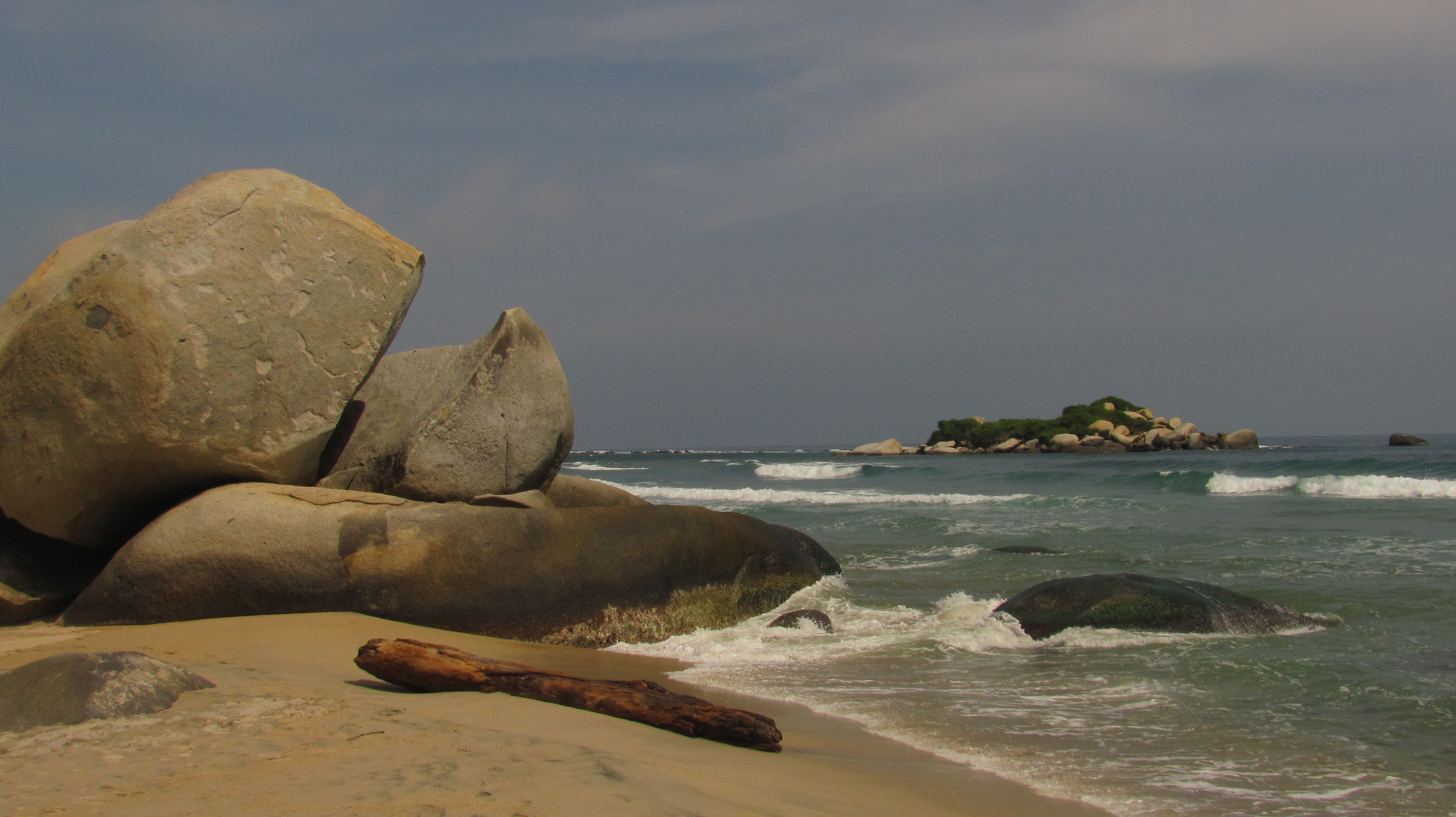
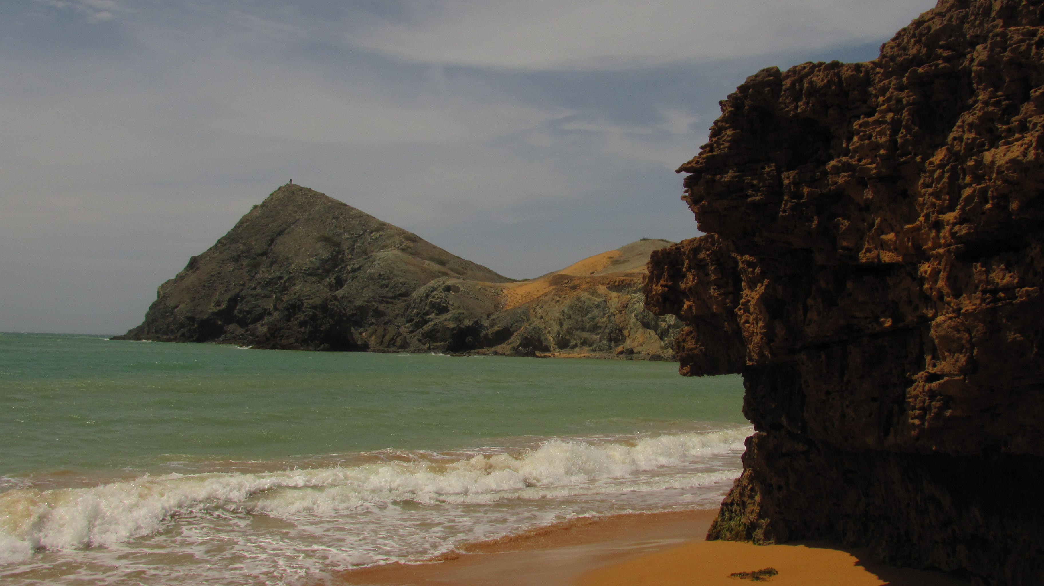
Scenery is a very important component for beach tourism and coastal economies. A scenic assessment recognizes the potential for coastal development in rural and remote areas and provides information to improve the scenic quality of village and urban areas. Each investigated littoral zone can be divided into five classes, from Class 1 for areas of high scenic values, to Class 5, including urban degraded areas with low scenic scores. Lowest scores usually are recorded in urban beaches where litter and sewage are frequently observed. At many sites, beach degradation is enhanced by erosion processes, which are counteracted by the construction of hard structures which further reduce the scenic value. Scenery assessments are mainly led by the community with experts and managers’ support. They are able to provide valuable input for this process through knowledge they gained from capacity building sessions. Scenery assessment outcomes inform revisions of conservation targets and identify areas that need more attention. Successful strategies are defined based upon the results of the assessment. Based on all the steps above, a scenery based management plan is developed and promotes creating a better littoral zone in terms of scenic value.
Building Blocks
Scenic Evaluation Tool Development
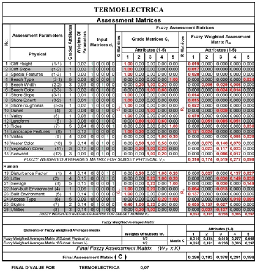
As part of a three-year study, an assessment was made of the main parameters essential for documenting coastal scenery perception. The assessment included a literature search, questionnaires given to coastal users in different parts of the world, and consultation with coastal landscape experts. Landscape values ‘can be assessed and described or illustrated in objective and subjective terms by landscape professionals, consulting with a wide range of interest groups and people and analyzing all relevant information’. Results obtained through this work enabled key elements to be condensed down to 26 ‘coastal scenic assessment parameters’. These parameters are: Cliff Height, Cliff Slope, Cliff Special Features, Beach Type, Beach Width, Beach Colour, Shore Slope, Shore Extend, Shore Roughness, Dunes, Valley, Land Form, Tides, Landscape Features, Vistas, Water Colour, Vegetation Cover, Seaweed, Disturbance Factor, Litter, Sewage, Non-Built Environment, Built Environment, Access Type, Skyline, Utilities.
Enabling factors
- Basic knowledge of spreadsheets
- Work related with checklists
Lesson learned
- Consultation with experts is necessary
- Avoid subjectivity
- Data sources should be in a good balance
Coastal scenery value determination
Scenery is a resource that has to be evaluated in an objective and quantitative manner to provide a means of comparison against other resource considerations and environmental impact assessments. Stakeholders survey specific littoral areas to determine the Scenic Evaluation, which indicates the ‘beauty’ of the study area. This is performed by using a coastal scenery survey checklist which itemizes 26 physical and human parameters, as a first step in quantifying scenery values.
Enabling factors
- Select and georeference the limits of the study area to replicate the survey in the future
- Centralize information. There are often many people involved, multiple surveys, and lot of data, but just one previously-designated stakeholder is in charge of the analysis.
Lesson learned
- Organization - scheduling activities is important.
- Data collection can complement a school class about coastal zone-related topics (geomorphology, geology, biology).
- Data sources should be in a good balance. Local knowledge and stakeholder consultation are necessary.
Coastal Scenery Management Plan
The coastal scenery classification is used by coastal managers, planners, academics, and governmental agencies, and local coastal zone managers. Evaluation of environmental, physical and usage parameters enables the identification and characterization of variables, which must be managed more effectively in order to promote overall improvements of the scenic value. Most sites have physical parameters for which coastal zone managers can do little or nothing to alleviate scenic impact, so emphasis should be given to assessing ways of improving different human usage parameters (i.e. litter collection campaign, fixing sewage-related problems, noise, access, utilities, etc.). Existing management plans can be revised or developed to consider scenery related issues by updating conservation targets’ statuses, identifying additional conservation targets, reviewing and revising weaknesses, and adjusting strategy and monitoring protocols. Additional scenery evaluations are required in order to evaluate plan effectiveness. The scenery management tool ensures a better littoral zone and long-term goods and services for local communities and tourists. It guides littoral managers to anticipate future impacts from human interventions.
Enabling factors
- Scenery Assessment outcomes as a basis for management plan development
- Involvement of local communities
- Training sessions on how to include scenery evaluation into existing management plans
- Participatory process involving managers and experts.
Lesson learned
- Encourage local communities and authorities to identify issues and come up with their own solutions which can be applied at the local level.
- Involvement of national government representatives is also a guarantee that the project will follow national guidelines and policies on littoral management.
Continuous monitoring
In order to ensure that the scenery values of the area are effectively protected, interested community members are trained in monitoring of scenery values using standardized techniques. Selection of trainees and implementation of continuous monitoring are done in coordination with the community.
Enabling factors
- Community support - Involvement of local communities
- Conditions for adoption elsewhere.
- Participatory process involving managers and experts.
Lesson learned
- It is important to encourage and support the community to play an active role in the management of the coastal scenery.
- Management of coastal scenery will never be self-sustaining until the communities no longer require external assistance.
Impacts
- From a social point of view, the assessment promotes community participation in evaluation and further management of the littoral zone. The solution increased awareness of the relevance of the littoral zone among practitioners and local communities in the project area and beyond. Coastal managers and planners develop an enhanced skillset and better understanding of scenery issues, including connections with their ‘business as usual’ work.
- From an ecological point of view, the quality of important ecosystems, such as beaches and cliff areas, is improved. This results from increased knowledge of ecological status of the littoral zone. Identifying and characterizing environmental, physical and usage variables, which must be managed in a better way promotes overall scenery improvements.
- From an economic point of view, improved scenic value means greater potential for economic development through tourism.
Beneficiaries
Local populations, local and municipal authorities, national tourism sector, and tourists.
Sustainable Development Goals
SDG 14 – Life below water
Story
“If you want to relax at the beach, you look for a good beach - remember Beauty lies in the eye of the beholder, in this case a tourist. Now, the flow of tourist has dropped, why?” – Roberto, a local fisherman. The scenic evaluation revealed that the natural beauty of this area is eclipsed by man-made activities and related products such as litter, sewage, and noise, among others problems. This is really an issue, due the close ties between the area’s economy and tourism. In order to resolve these issues, a management plan was created for a pilot area in order to recover the area’s natural beauty. The plan consists of raising the score of all the evaluation tool’s parameters with initially poor scores after the first scenic evaluation, or “hot spots”. Roberto the fisherman worked to improve all the "hot spots,” to make the area more attractive to tourists. His actions included:
- continuously removing litter and conducting cleanup campaigns
- removing the visual contamination
- reducing noise
- improving beach access,
- and upgrading basic utilities (WC, Showers, among others).
After 3 month of applying the plan, Roberto says: “Things become normal again!”