Ecosystem-based coastal protection through floodplain restoration
Full Solution
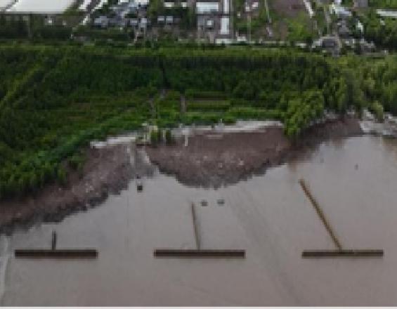
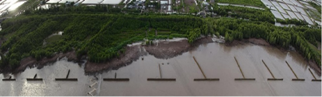
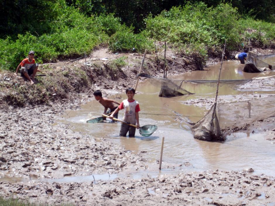
T-shaped fences in the provinces of Bac Lieu and Soc Trang. The long-shore elements close the eroded gap in the mangrove forest by connecting the remaining headlands.
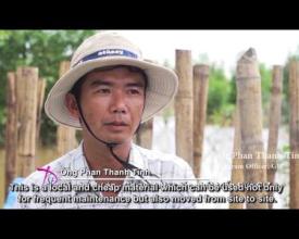
Cong Ly, GE Wind
The solution provides protection of the muddy coasts and the people living near the coast from floods, storm surges and erosion. This is achieved by restoring eroded floodplains as precondition for natural regeneration or rehabilitation of mangrove forests as elements of an ecosystem-based approach to area coastal protection. T-shaped, permeable bamboo fences filled with soft brushwood bundles are effective at restoring eroded flood plains. This solution only works within a specific set of boundary conditions and must be site-specific and appropriate. Developed for the Lower Mekong Delta’s muddy coast in Vietnam, it provides security for people living directly behind dykes.
Last update: 17 Jun 2021
11678 Views
Photo and video gallery
Context
Challenges addressed
Along the mangrove mud-coasts of the Mekong Delta, erosion, flooding and storms are affecting the livelihood and life of thousands, often poor farmers and fishers. Once the mangroves, which protect the coast, are degraded or destroyed, waves will erode the floodplains and then waves will start eroding the earth dyke. This will lead to dyke overtopping and eventually destruction of the dyke. Solutions such as strengthening the dyke with sandbags or gabions are only temporary measures which don’t address the root cause – a low floodplain due to erosion. Therefore, a solution is required which address the root cause.
Location
Soc Trang Province, Vietnam
Southeast Asia
Process
Summary of the process
The building blocks build on each other to achieve a sound solution to sustainably restore floodplains, and rehabilitate mangrove belts and their ecosystem services. The ‘Numeric modelling of hydro- and sediment-dynamics’ (building block 1) provides the sound basis to fully understand local dynamics at the area as well as providing important boundary conditions for the design and construction of the breakwaters. It is the necessary prerequisite for building block 2, the ‘Planning, design and construction of appropriate breakwaters’, which includes selection of suitable sites for construction of T-fences. The two first building blocks thus contribute to sediment accretion where desired and natural mangrove regeneration. Building block 3 ‘Breakwater monitoring and maintenance’ ensures proper functioning of the infrastructure component itself, and building block 4 ‘Mangrove protection and planting’ completes the solution by protecting natural mangrove regeneration and, if necessary, supplementary planting of appropriate species. The creation of awareness and ownership by involving all stakeholders is not only crucial for the success of each building block but also for the long-term sustainability of the solution.
Building Blocks
Numeric modelling of hydro- and sediment-dynamics
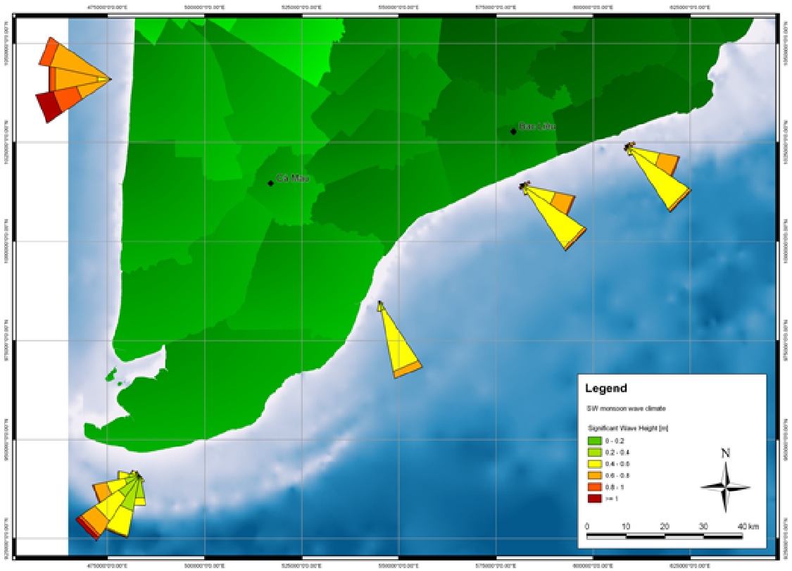
This tool serves the purpose of understanding and projecting natural forces which are shaping the shoreline in order to plan the optimal placement and design of breakwaters: Use available and field data (for all seasons) on near shore bathymetry (depth profiles), wave height, direction, and period; tidal regime and currents; sediment composition (seabed and suspended), and wind patterns, to calibrate and validate numerical models. Map outputs on wave climate, tidal regime, sediment transport and bathymetry. Use projected hydro- and sediment dynamic conditions to determine feasibility, best design and placement of breakwaters.
Enabling factors
- Coasts dominated by muddy sediments (fine sand, silt, clay).
- A relatively shallow near shore with little slope in the bathymetric profile.
- Sufficient suspended sediment supply.
- Possibility to use T-fences to recreate original coastline between existing headlands with mangrove forest cover.
- Historical records of mangrove occurrence for the site to assess feasibility of natural regeneration of mangroves or mangrove rehabilitation.
Lesson learned
Coastal engineering know-how, specialized software and facilitation proved to be compulsory. Engagement of local technical departments and responsible authorities as well as proper information is necessary to ensure commitment and long-term support. Prioritization of sites by local authorities, or due to socio-economic values connected to the use of the hinterland, must be taken into account. Relevant authorities and partners should be made aware that results of numerical modelling may prove valuable for other measures planned in the area. This can increase efficiency and create valuable synergies.
Planning and construction of breakwaters
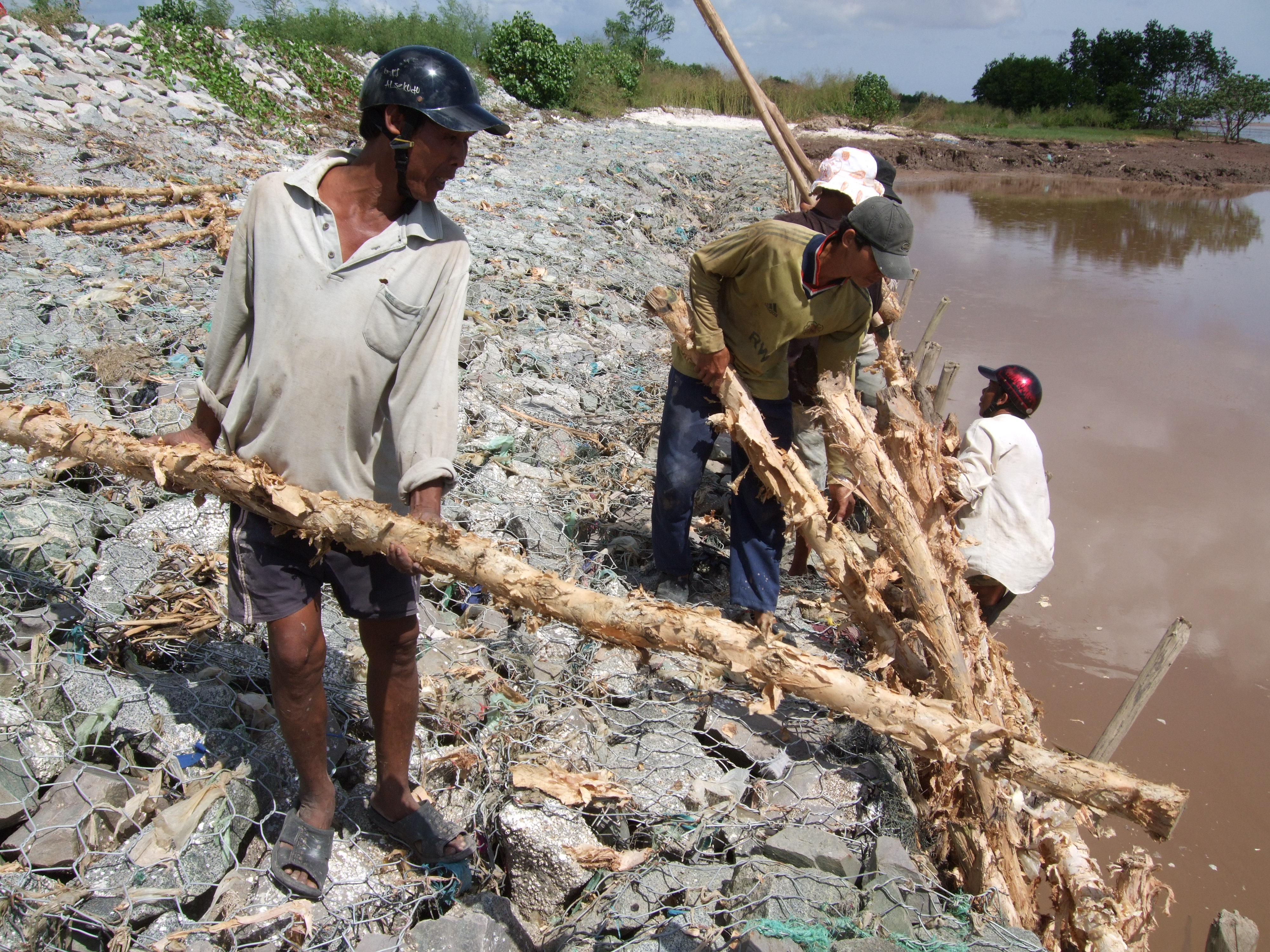
Physical models determine the optimal design of the actual breakwaters. The strength of the bamboo poles was tested during field testing of the fences. Durability information of bamboo is derived from experiences using bamboo in Thailand. Local people are informed of and engaged in the planned activity. With technical support, local people construct breakwaters, i.e. T-shaped fences from natural materials (bamboo). Permeable T-fences do not inhibit sediment input and create calm water conditions for sediment deposition. The long-shore parts break the waves and the cross-shore elements catch sediments suspended in long-shore currents. The gaps in the long-shore parts improve sediment input into the fields created by the fences during flood tide, while drainage is accelerated through the openings during ebb tide, thereby accelerating the soil consolidation process in the fields.
Enabling factors
Successful design and construction depend on results from numerical modelling, observations from coastline changes, records of erosion and sound execution of T-fence construction and construction supervision.
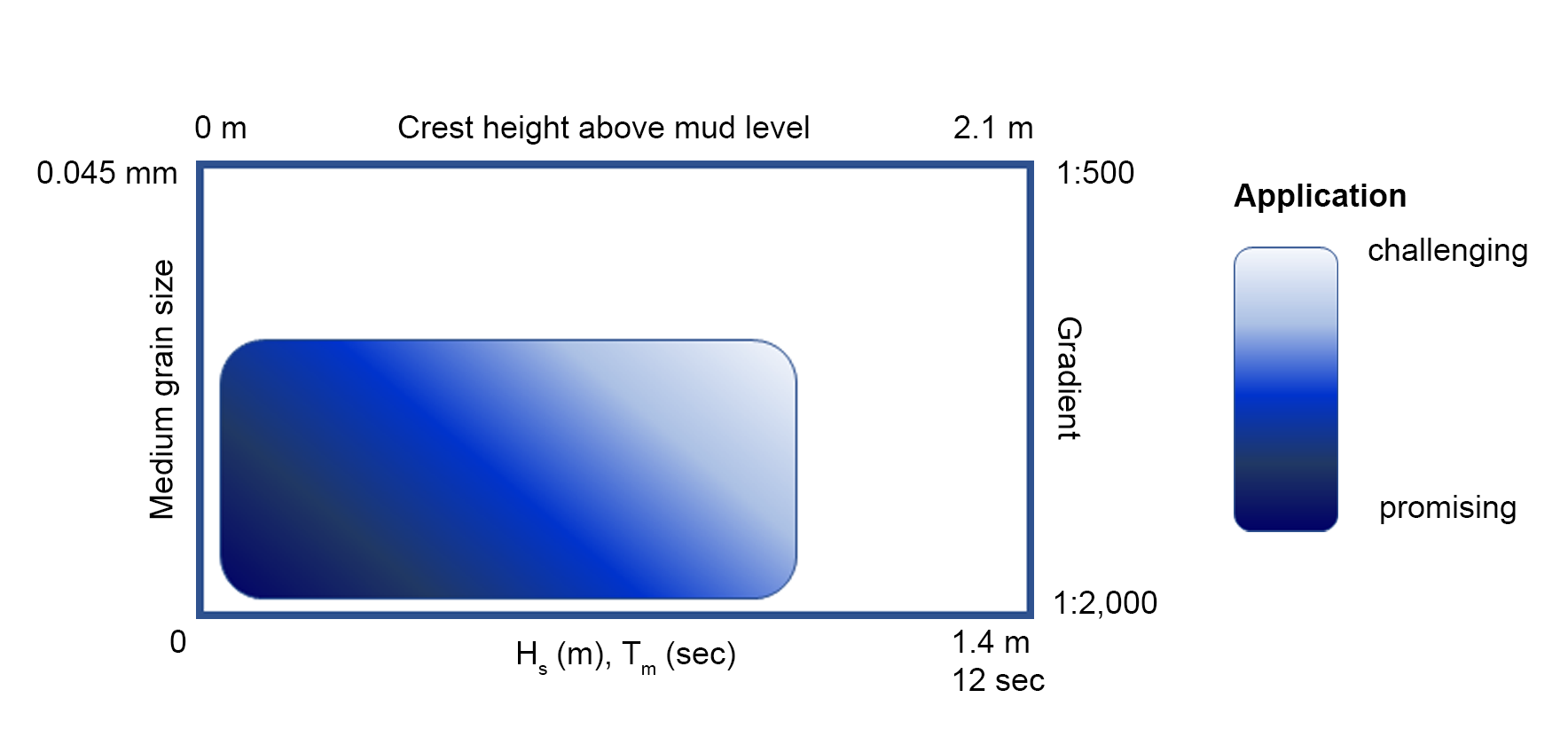
The following boundary conditions must be fulfilled to ensure that the fences are effective:
- Muddy environment; medium grain size diameter of top layer of the mud d50 < 0.03 mm
- Significant wave height Hs < 0.90 m
- Mean wave period Tm < 8 s
- Small gradient of the tidal flat < 1:1000
- Clearance of the crest of the construction < 1.40 m
Lesson learned
Involvement of technical departments and local authorities and people in the planning, design and construction process was important to ensure acceptance, support, long-term commitment and ownership. The most effective way to restore eroded foreshores is to use permeable t-fences which create calm water conditions for sediment deposition and reduce erosion. Construction of the T-fences must follow quality standards and must be well supervised. This cost-effective approach will only be feasible within a specific set of boundary conditions (see graphic below). If these limiting criteria are exceeded to only a small extent, adaptations such as strengthening the fence with concrete poles must be considered. If the limiting criteria are exceeded to a large extent, use of T-fences is not feasible. Other factors to be considered are location of the fences to minimise lee erosion, as well as proximity to the shoreline and length of submergence periods to minimise damage by shipworms. The duration of submergence and exposure to waves also affect the effort required for maintenance.
Breakwater monitoring and maintenance
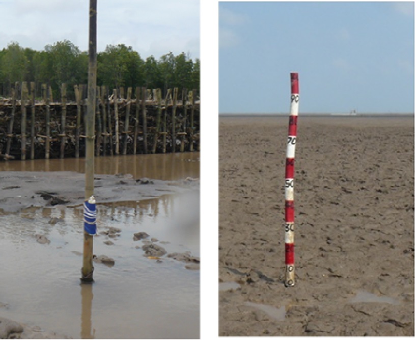
A monitoring system is used to measure sediment accretion, and to monitor the condition of the T-fences. In addition, natural regeneration of mangroves is monitored. During the first year after construction, functionality of the T-fences should be ensured through monthly visual inspections and maintenance where necessary. After one year, visual inspections and maintenance should be carried out at least after the end of every storm season. In addition, seasonal GPS surveys of the shore line at low tide can be used to see whether the T-fences have impacts on the shape of the coastline nearby. The natural regeneration of mangroves is documented by recording species, size and density or through fixed-point photos. The latter can also be used as a simple alternative for GPS shore line surveys.
Enabling factors
- Know-how and manpower for regular surveys (data collection for monitoring) and routine visual construction inspections.
- Benchmark poles for recording vertical accretion at several transects.
- Fixed point photos are an easy to use tool to monitor mangrove regeneration and shoreline changes.
- Measurements of sediment consolidation (mud-density).
- GPS survey equipment and know-how for long-term surveillance.
Lesson learned
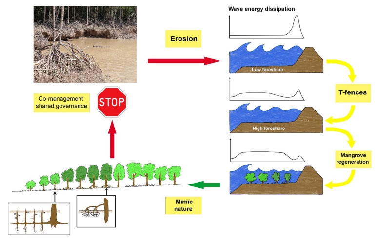
A standardized monitoring system for the condition of breakwaters, accretion of sediments and natural regeneration of mangroves is crucial for measuring the long-term success of T-fences. The need for maintenance and repair works may vary considerably between sites. Long-term surveillance based on GPS surveys must include neighbouring areas to discover possible negative side effects of T-fences (down drift erosion). It is important to realize that once floodplains are restored and an appropriate mangrove cover is in place, mangrove protection measures must be implemented to ensure sustainability of coastal protection. Once the mangrove forest is fully established, the breakwater construction is no longer needed. This process may take several years.
Mangrove protection and planting
Bamboo T-fences are used to restore eroded floodplains and the fine sediment balance as a precondition for natural regeneration of mangroves forests – the latter will then form part of an effective area coastal protection strategy. After successful restoration of sites suitable for mangrove growth, natural regeneration of mangroves will occur. It is, however, essential that the mangroves are protected from human impacts, otherwise the cycle of degradation/destruction and expensive restoration will continue uninterrupted (see illustration under "How do the building blocks interact in the solution?"). This can best be achieved by involving local people in effective protection and management of mangroves through co-management. For more information see solution “Co-management (shared governance) of natural resources in the coastal area”. If rates of natural regeneration are insufficient, supplementary planting of mangroves may be necessary. In such cases, appropriate species need to be planted at the right sites at the correct time.
Enabling factors
• Decision-makers understand coastal processes and mangrove ecology. • All stakeholders are willing to engage in shared governance (co-management) of mangroves.
Lesson learned
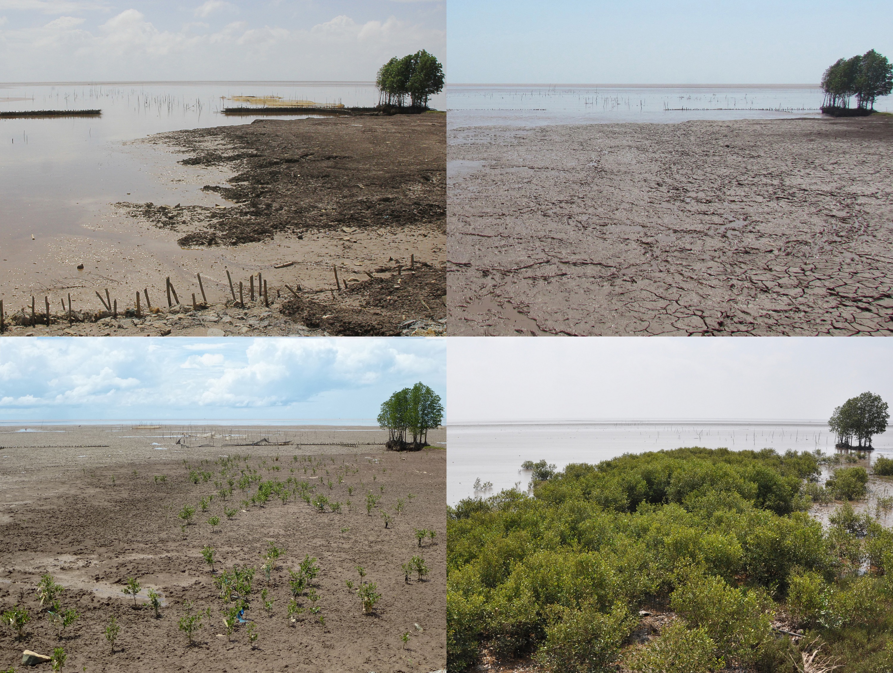
Co-management, or shared governance, is an approach for sustainable and effective mangrove protection and management. It also provides livelihood for local people and contributes to better governance of natural resources. The results of the fixed-point photo monitoring from the coast of Soc Trang Province (Vietnam) from Nov. 2012 until Jan. 2015 clearly show the impacts of T-fences on sedimentation and, as a result, on natural regeneration of mangroves. Mangrove foresters need a sound understanding of mangrove ecology and of coastal processes and morphodynamics. The most effective way of planting mangroves is to learn from nature, i.e. mimic how nature plants, which species nature plants and the way nature creates a species zonation. This zonation leads to optimised coastal protection through wave attenuation by above-ground root structures along with soil stabilisation by below-ground root structures (see illustration in "How do the building blocks interact in the solution?").
Impacts
Technically, the solution is effective for flood, storm surge and erosion protection, and increasing biodiversity and availability of ecosystem services through floodplain restoration as a precondition for mangrove rehabilitation in sites where the floodplains have been eroded. Mangroves provide nursery, food and shelter for many aquatic species. They are highly productive and up to 80% of near-shore fishery catches globally are directly or indirectly dependent on mangroves. The values of mangroves have been estimated to be between US$ 2,000 - US$ 9,990 per hectare per year and thus rank among the most economically valuable of all ecosystems. Mangroves sequester up to 5 times more carbon than tropical rain forests. Financially, direct costs for dyke maintenance and repair were drastically reduced. Socio-economic impacts are security for people living directly behind the dyke, securing livelihoods by improving small-scale fishery and aquaculture.
Beneficiaries
The people living behind sea-dykes and in flood-prone areas, fishermen and aquaculture farmers.
Story
Mrs. Sà Vọng has lived near Nopol at the coast of Soc Trang Province as long as she can remember. Her family had a good life collecting fire wood, catching fish, collecting clams and cockles in the mangrove forest and on mudflats to supplement the income from her small fish pond. Many people used the road next to her house to access the mangrove forest just beyond the earth dyke which was built after a big storm 20 years ago. Over time the small path that was thus created through the mangroves to access the mudflats with their abundance of aquatic resources such as goby fry, cockles and juvenile crabs grew wider and could be used by small fishing boats. This development led to erosion. Over time it destroyed a 100 m long stretch of mangrove forest in front of the dyke. As a result Mrs. Sà Vọng saw that during the stormy season and high tides waves often overtopped the dyke and salt water flooded her small vegetable garden and her house. When the dyke threatened to break, local authorities spent much money to raise its height and to re-enforce its front with gabions and Melaleuca poles. After most spring high tides the dyke had to be repaired again as shown in the picture from Vinh Tan (near Nopol). The GIZ project, Management of Natural Resources in the Coastal Zone of Soc Trang Province, was asked to assist local authorities to find better solutions. To ensure the long-term viability, the project applied an ecosystem-based approach to restore eroded floodplains through T-shaped bamboo fences as a precondition for the subsequent natural regeneration of mangroves. In May 2012 the construction of T-fences started. Already during the construction work Mrs. Sà Vọng told project staff that she is very happy as waves no longer reach the dyke, and her house is no longer subject to floods or strong wind. Only one year after construction a lot of sediments had accumulated behind the T-fences and started to consolidate to allow for mangroves to reappear. At a nearby T-fence site Avicennia seedlings occurred and grew well only 9 months after completion of the T-fences. This is a clear indication that the T-fences have re-created conditions suitable for the growth of mangroves.
Connect with contributors


Other contributors
Dr. Klaus Schmitt
Deutsche Gesellschaft für Internationale Zusammenarbeit (GIZ) GmbH
Dr. Stefan A. Groenewold
Deutsche Gesellschaft für Internationale Zusammenarbeit (GIZ) GmbH