Effective management measures for dynamic monitoring of resource management and protection in Shaanxi Changqing National Nature Reserve
Full Solution

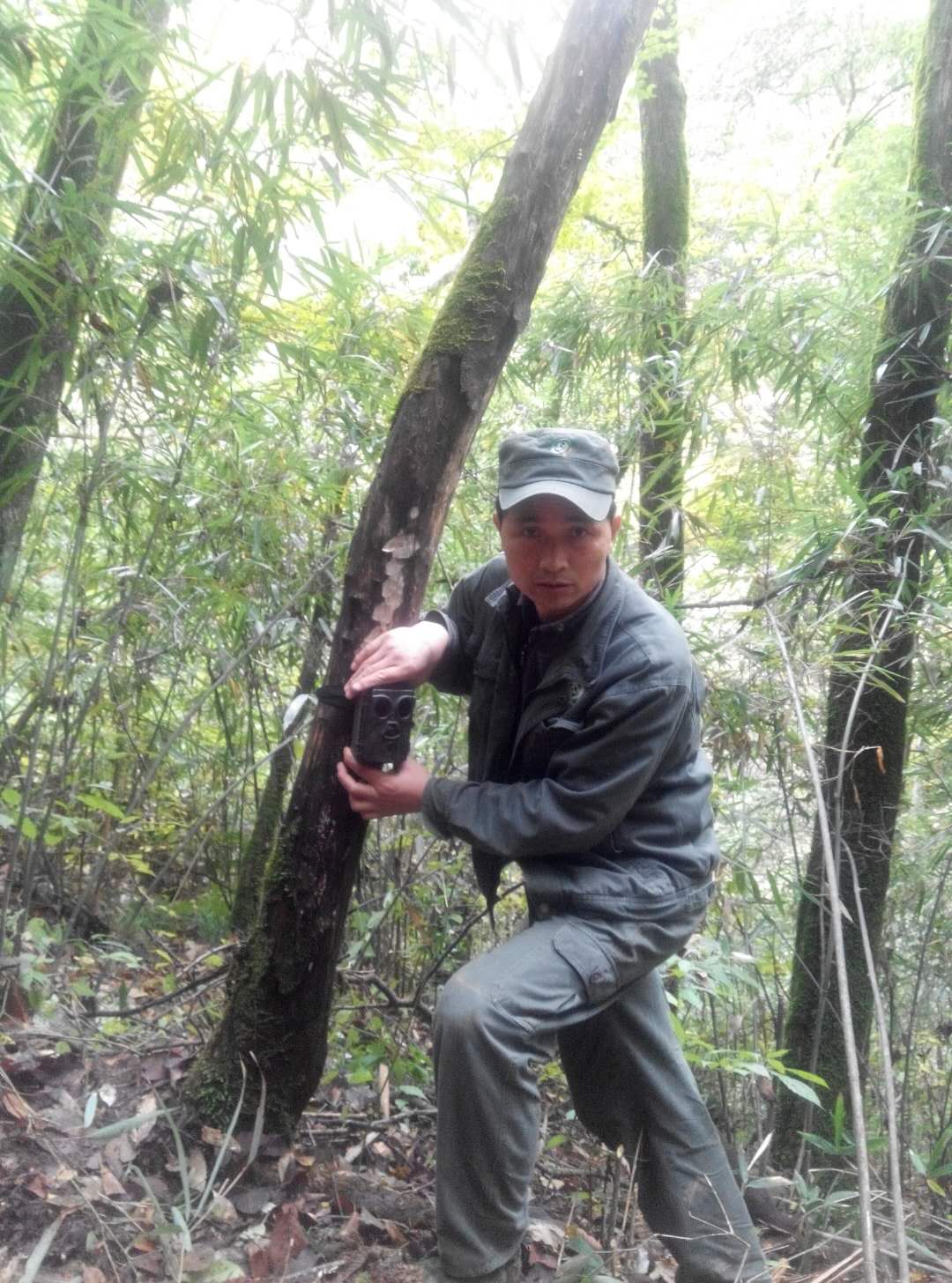
Infrared camera layout method
Shaanxi Changqing National Nature Reserve Administration
The Changqing Nature Reserve is located in Yangxian County on the Southern slope of the middle section of the Qinling Mountains, which is also located at the source of the Youshui River, a tributary of the Han River, and is adjacent to 9 administrative villages. The community situation is complex and human activities occur from time to time. In order to improve this situation, since 2014, the reserve has innovatively applied far-infrared cameras to resource management and protection, and combined with community visits, daily inspections, laws and regulations publicity, project introduction and so on, which has greatly reduced the frequency of human access to the reserve in community, ensured the safety of wild animal and plant resources in the jurisdiction, and also alleviated the conflicts between communities and protected areas.
Last update: 02 Oct 2020
2465 Views
Photo and video gallery
Context
Challenges addressed
- The implementation of the project requires the sustaining support of special funds;
- There is a certain conflict of interest with the community, which will cause the camera to be damaged and lost;
- Poaching, and it can destroy the habitat of wildlife.
Location
Yangxian,Hanzhong, Shaanxi, People's Republic of China
East Asia
Process
Summary of the process
The operation between modules is very simple. The first step is to collect the influence of human interference using the infrared camera technology. The second step is to assign specific person to identify and classify the collected image data. The third step is that we carry out the work based on the identified human interference information. With the long time data accumulation, we can establish major protected areas and people in the reserve to guide the selection and placement of camera sites in the first step, making it more scientific and targeted. The three are closely linked, interacted with each other and complementary, which is a very effective protection management measure. It can not only improve the conservation efficiency but also significantly reduce the frequency of human activities, so it can be said to have strong popularization and operability.
Building Blocks
Camera layout and data collection
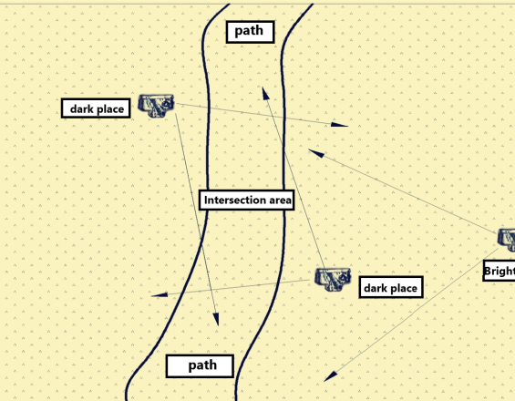
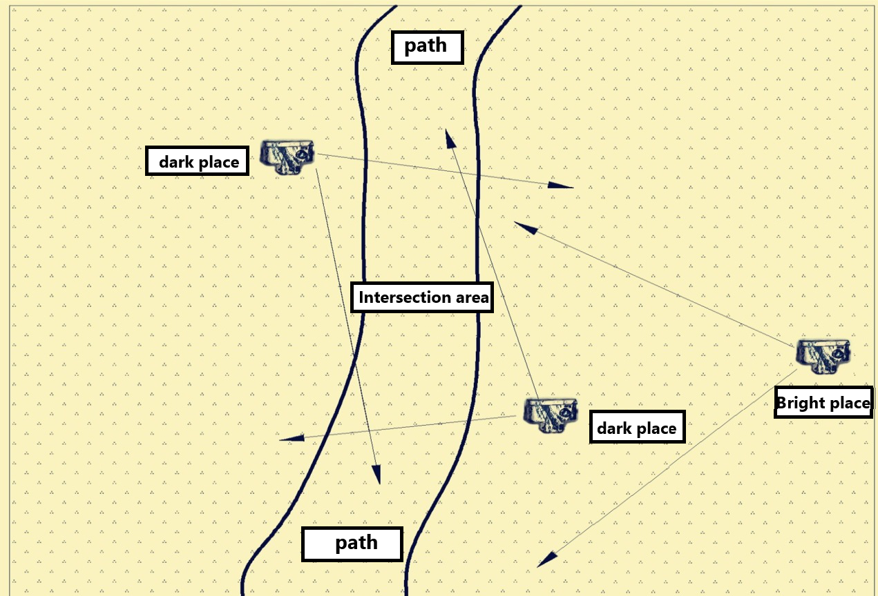
Combined with the geographic feature of the reserve, seasonal characteristics, community distribution, and the key natural resources, field workers set up monitoring sites on the main roads and ravine mouths in the area, and use the “two bright and one dark” method for camera deployment, that is, the two cameras consider the lens orientation, distance, and quality of images to ensure that clear pictures or videos of the front of the entrant are taken without leaving dead spots in the blind zone, and the third camera focuses on the safety of the first two cameras, placed in a high covert and not easy to be found location, and the visual field must include the first two infrared cameras to prevent malicious damage to the monitoring equipment, otherwise, the data will be lost.
Enabling factors
The first one is that the camera installer is proficient in infrared camera layout skills, the second is that the camera placement site can be selected properly, the third is that the work plan is combined with the actual situation, and the fourth is the corresponding reward and punishment mechanism.
Lesson learned
First, the parameters, the orientation, and the height of the camera must be correct to reduce the number of invalid photos. Second, the camera must be located at an appropriately concealed area to reduce the camera loss rate.
Data recovery and identification
The Administration Bureau arranges the office workers to identify, classify and input data according to the staff, human activity information, and animal resource information. The office workers distinguish the photos of the human activities, and determine the specific information of the personnel (community personnel or not ).
Enabling factors
1. Recycle and appraise camera data timely in accordance with the plan.
2. Maintain equipment regularly.
3. The identification of the camera data must be unified.
4. Carry out follow-up work immediately for discovered human activities.
5. Corresponding reward and punishment mechanisms.
Lesson learned
1. Number the camera´s data cards uniformly to avoid data confusion.
2. Replace the malfunction cameras timely.
3. Arrange fixed staff to identify the data.
Community visits and education
Aim at human interference information, and timely organize management and protection personnel to carry out community visits, special inspections, etc. For the people involved we can provide verbal warnings, legal warnings and education, and registration for the record in accordance with the "Regulations on the Management of Nature Reserves".
Enabling factors
According to the identified information, the follow-up work was carried out in time, and major management areas and major management crowd were established, with long-term timeliness, we can introduce projects to the community and increase the income of the community.
Lesson learned
Combining with years of data can be representative and referential. When launching a warning education, we should pay attention to methods and ways to reduce conflicts of interest, and to improve awareness of resource protection.
Impacts
- The awareness of the community about protection of resources has been improved, and the traditional use and dependence on natural resources have all been improved;
- The methods of resource management in the reserve are more effective, ensuring that the resources in the area can be better protected, and the information of personel who entered the area illegally has been controlled, obtaining objective and accurate evidence for forestry administrative law enforcement;
- Saving manpower and financial resources, and saving cost of resource conservation.
Beneficiaries
- Wildlife authorities
- Local communities
- Conservationists
Sustainable Development Goals
SDG 3 – Good health and well-being
SDG 4 – Quality education
SDG 6 – Clean water and sanitation
Story
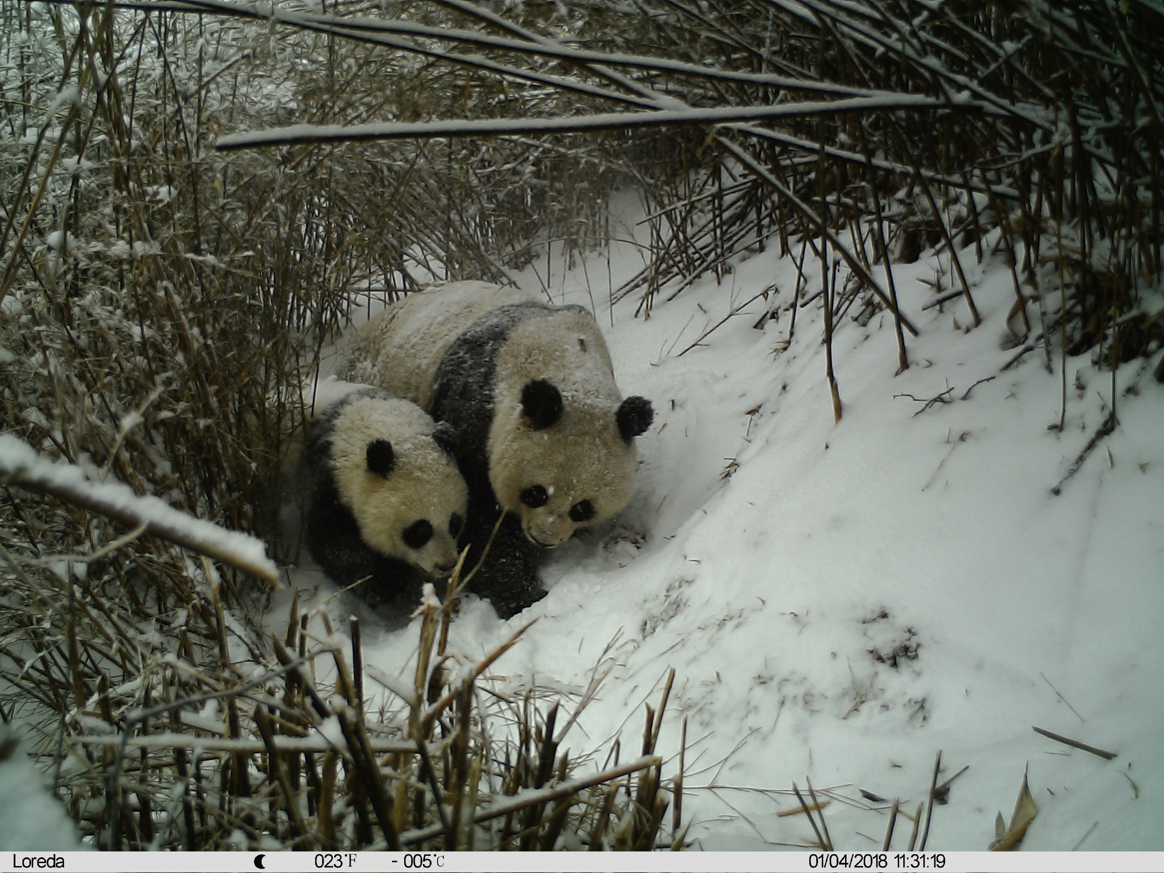
Baiyangping belongs to the core area of Changqing Nature Reserve in Shaanxi Province, and it is one of the areas where wild giant pandas are most commonly encountered in China. It is also the key monitoring area for the dynamic monitoring of human activities by infrared cameras in the giant panda protection in Changqing Nature Reserve. The use of infrared-triggered selfie cameras for dynamic monitoring of human activities has effectively collected information on human activities, and cracked down on illegal poaching of wild animals and plants. Consequently, those cameras become the reserve's hawk-eye, the day and night guardians.
Last summer, we arranged a group of infrared cameras on the main roads in the Baiyangping area. The three cameras were placed in different locations to complement each other and monitor. Monitoring found that Zhang Moumou, a villager in Banqiao Community, and three neighbors illegally entered the protected area to dig Chinese medicinal materials. Zhang Moumou found an infrared camera. They were worried that their illegal activities were exposed, so they took the camera down to the river to burry it. But what they didn't expect was that another infrared camera quietly captured their activity on photos and videos. After that, we accurately found Zhang Moumou based on the video and audio data of the other two cameras. At the beginning, he refused to admit his illegal behavior. After we presented the video and audio evidence captured by the infrared camera, he immediately confessed his illegal behavior and stated that he sincerely regretted it and went to the site to identify the scene and actively excavated the buried infrared camera. In view of their repentance, we have raised awareness and educated them about the law. They in turn apologized in writing and pledged to study the laws and regulations of wildlife protection in the future and support the protection and management of protected areas.
This case played well as a warning and education role in the local community, which enhanced the awareness of the rule of law among the residents of the community, showed employees the image of scientific management and protection, law enforcement and fair law enforcement in the reserve, and highlighted the effect of dynamic monitoring of human activities with infrared cameras, powerfully promoting the protection and management of resources in the reserve.
Connect with contributors
Other contributors
Shan Guo Yu
Shaanxi Changqing Nature Reserve Administration
Wang Hong Juan
Shaanxi Changqing Nature Reserve Administration
Zhang Yong Wen
Shaanxi Changqing Nature Reserve Administration
Huang Jing
Shaanxi Changqing Nature Reserve Administration
Dong Wei
Shaanxi Changqing Nature Reserve Administration