Medidas de gestión eficaces para el seguimiento dinámico de la gestión y protección de los recursos en la Reserva Natural Nacional de Shaanxi Changqing

La Reserva Natural de Changqing está situada en el condado de Yangxian, en la vertiente meridional de la sección media de los montes Qinling, que también se encuentra en el nacimiento del río Youshui, afluente del río Han, y linda con 9 pueblos administrativos. La situación de la comunidad es compleja y se producen actividades humanas de vez en cuando. Para mejorar esta situación, desde 2014, la reserva ha aplicado de forma innovadora cámaras de infrarrojos lejanos a la gestión y protección de los recursos, y las ha combinado con visitas a la comunidad, inspecciones diarias, publicidad de leyes y reglamentos, introducción de proyectos, etc., lo que ha reducido en gran medida la frecuencia del acceso humano a la reserva en la comunidad, ha garantizado la seguridad de los recursos animales y vegetales salvajes en la jurisdicción, y también ha aliviado los conflictos entre las comunidades y las áreas protegidas.
Contexto
Défis à relever
- La ejecución del proyecto requiere el apoyo sostenido de fondos especiales;
- Existe un cierto conflicto de intereses con la comunidad, que hará que la cámara se dañe y se pierda;
- La caza furtiva, y puede destruir el hábitat de la fauna silvestre.
Ubicación
Procesar
Resumen del proceso
El funcionamiento entre módulos es muy sencillo. El primer paso consiste en recoger la influencia de la interferencia humana mediante la tecnología de cámara de infrarrojos. El segundo paso consiste en asignar a una persona específica la tarea de identificar y clasificar los datos de las imágenes recogidas. El tercer paso es llevar a cabo el trabajo basándonos en la información identificada sobre la interferencia humana. Gracias a la acumulación de datos durante mucho tiempo, podemos establecer las principales zonas protegidas y personas de la reserva para orientar la selección y ubicación de los emplazamientos de las cámaras en el primer paso, lo que lo hace más científico y específico. Los tres están estrechamente vinculados, interactúan entre sí y se complementan, lo que constituye una medida de gestión de la protección muy eficaz. No sólo puede mejorar la eficacia de la conservación, sino también reducir significativamente la frecuencia de las actividades humanas, por lo que puede decirse que tiene una fuerte popularización y operatividad.
Bloques de construcción
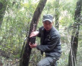
Disposición de las cámaras y recogida de datos
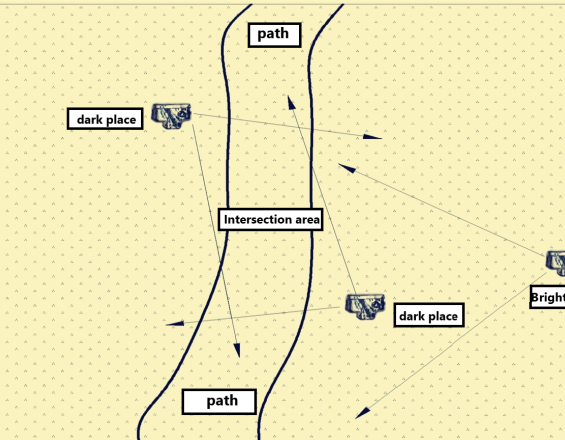
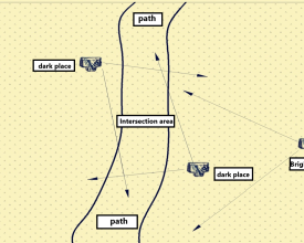
En combinación con la característica geográfica de la reserva, las características estacionales, la distribución de la comunidad y los recursos naturales clave, los trabajadores de campo establecen lugares de vigilancia en las principales carreteras y desembocaduras de barrancos de la zona, y utilizan el método de "dos claras y una oscura" para el despliegue de las cámaras, es decir, las dos cámaras tienen en cuenta la orientación del objetivo, la distancia y la calidad de las imágenes para garantizar que se toman imágenes o vídeos nítidos de la parte delantera del entrante sin dejar puntos muertos en la zona ciega, y la tercera cámara se centra en la seguridad de las dos primeras, colocada en un lugar muy encubierto y no fácil de encontrar, y el campo visual debe incluir las dos primeras cámaras de infrarrojos para evitar daños malintencionados al equipo de vigilancia, de lo contrario, se perderán los datos.
Factores facilitadores
La primera es que el instalador de la cámara domine los conocimientos de disposición de cámaras de infrarrojos, la segunda es que el lugar de colocación de la cámara pueda seleccionarse adecuadamente, la tercera es que el plan de trabajo se combine con la situación real, y la cuarta es el correspondiente mecanismo de recompensa y castigo.
Lección aprendida
En primer lugar, los parámetros, la orientación y la altura de la cámara deben ser correctos para reducir el número de fotos no válidas. En segundo lugar, la cámara debe estar situada en una zona adecuadamente oculta para reducir la tasa de pérdida de cámaras.
Recuperación e identificación de datos
La Oficina de Administración organiza a los oficinistas para que identifiquen, clasifiquen e introduzcan los datos en función del personal, la información sobre actividades humanas y la información sobre recursos animales. Los oficinistas distinguen las fotos de las actividades humanas y determinan la información específica del personal (personal comunitario o no ).
Factores facilitadores
1. Reciclar y valorar oportunamente los datos de las cámaras de acuerdo con el plan.
2. Mantener los equipos con regularidad.
3. La identificación de los datos de la cámara debe estar unificada.
4. Realizar inmediatamente las labores de seguimiento de las actividades humanas descubiertas.
5. Mecanismos de recompensa y castigo correspondientes.
Lección aprendida
1. Numere las tarjetas de datos de la cámara de manera uniforme para evitar la confusión de datos.
2. Sustituya a tiempo las cámaras averiadas.
3. 3. Disponga personal fijo para identificar los datos.
Visitas a la comunidad y educación
Apuntar a la información sobre interferencias humanas, y organizar oportunamente al personal de gestión y protección para realizar visitas a la comunidad, inspecciones especiales, etc. A las personas implicadas podemos hacerles advertencias verbales, advertencias legales y educación, e inscribirlas en el registro de acuerdo con el "Reglamento de Gestión de Reservas Naturales".
Factores facilitadores
De acuerdo con la información identificada, el trabajo de seguimiento se llevó a cabo a tiempo, y se establecieron las principales áreas de gestión y la mayor multitud de gestión, con puntualidad a largo plazo, podemos introducir proyectos en la comunidad y aumentar los ingresos de la comunidad.
Lección aprendida
La combinación con años de datos puede ser representativa y referencial. A la hora de poner en marcha una educación de alerta, debemos prestar atención a los métodos y formas de reducir los conflictos de intereses y mejorar la concienciación sobre la protección de los recursos.
Impactos
- Se ha mejorado la concienciación de la comunidad sobre la protección de los recursos, así como el uso tradicional y la dependencia de los recursos naturales;
- Los métodos de gestión de los recursos de la reserva son más eficaces, lo que permite proteger mejor los recursos de la zona, y se ha controlado la información de las personas que entraron ilegalmente en la zona, obteniendo pruebas objetivas y precisas para la aplicación de la ley administrativa forestal;
- Ahorro de mano de obra y recursos financieros, y ahorro de costes de conservación de los recursos.
Beneficiarios
- Autoridades responsables de la fauna
- Comunidades locales
- Conservacionistas
Objetivos de Desarrollo Sostenible
Historia
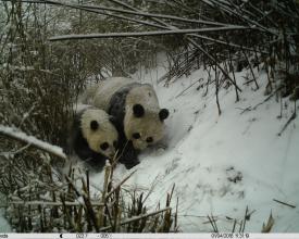
Baiyangping pertenece a la zona núcleo de la Reserva Natural de Changqing, en la provincia de Shaanxi, y es una de las zonas donde es más frecuente encontrar pandas gigantes salvajes en China. También es la zona clave para el seguimiento dinámico de las actividades humanas mediante cámaras de infrarrojos en la protección del panda gigante en la Reserva Natural de Changqing. El uso de cámaras selfie con infrarrojos para la vigilancia dinámica de las actividades humanas ha permitido recabar información sobre las mismas y reprimir la caza furtiva ilegal de animales y plantas silvestres, por lo que esas cámaras se han convertido en el ojo de halcón de la reserva, en sus guardianes diurnos y nocturnos.
El verano pasado, dispusimos un grupo de cámaras de infrarrojos en las carreteras principales de la zona de Baiyangping. Las tres cámaras se colocaron en lugares distintos para complementarse y vigilar. La vigilancia descubrió que Zhang Moumou, un aldeano de la comunidad de Banqiao, y tres vecinos entraron ilegalmente en la zona protegida para excavar materiales medicinales chinos. Zhang Moumou encontró una cámara de infrarrojos. Les preocupaba que sus actividades ilegales quedaran al descubierto, así que se llevaron la cámara al río para enterrarla. Pero lo que no esperaban era que otra cámara de infrarrojos captara en silencio su actividad en fotos y vídeos. Después de eso, encontramos con precisión a Zhang Moumou basándonos en los datos de vídeo y audio de las otras dos cámaras. Al principio, se negó a admitir su comportamiento ilegal. Después de que le presentáramos las pruebas de vídeo y audio captadas por la cámara de infrarrojos, confesó inmediatamente su comportamiento ilegal y declaró que se arrepentía sinceramente y acudió al lugar para identificar la escena y excavó activamente la cámara de infrarrojos enterrada. En vista de su arrepentimiento, le hemos concienciado e instruido sobre la ley. A su vez, se disculpó por escrito y se comprometió a estudiar las leyes y reglamentos de protección de la fauna en el futuro y a apoyar la protección y gestión de las zonas protegidas.
Este caso desempeñó un buen papel de advertencia y educación en la comunidad local, que aumentó la concienciación sobre el estado de derecho entre los residentes de la comunidad, mostró a los empleados la imagen de la gestión y protección científicas, el cumplimiento de la ley y la aplicación justa de la ley en la reserva, y puso de relieve el efecto de la vigilancia dinámica de las actividades humanas con cámaras de infrarrojos, promoviendo poderosamente la protección y gestión de los recursos en la reserva.


