Empowering Mandingalbay Yidinji people through P3DM

Full Solution
Empowering Mandingalbay Yidinji people through P3DM
TBC

Mandingalbay Yidinji (MY) people from the Wet Tropics World Heritage Area, Australia, have used Participatory 3 Dimensional Modelling (P3DM) to empower their community through the mapping and sharing of cultural and landscape knowledge. The project was facilitated by Wet Tropics Management Authority, and involved all of the MY community. Decision making about what to show, and what to exclude, was made entirely by the MY people.

Last update: 02 Oct 2020
7157 Views
Context
Challenges addressed
Erratic rainfall
Floods
Salinization
Tropical cyclones / Typhoons
Tsunami/tidal wave
Wildfires
Conflicting uses / cumulative impacts
Invasive species
Changes in socio-cultural context
Poor governance and participation
Unemployment / poverty

loss of cultural information in protected areas Much vital cultural information in protected areas is lost when knowledge holders die, are disconnected and/or when they cannot access key cultural sites. Many methods of mapping culturally sensitive information are untrusted and overly technical. P3DM empowers indigenous people as the drivers of the process.

Scale of implementation
Local
Subnational
Global
Ecosystems
Temperate evergreen forest
Estuary
Mangrove
Salt marsh
Seagrass
Wetland (swamp, marsh, peatland)
Theme
Access and benefit sharing
Health and human wellbeing
Indigenous people
Local actors
Traditional knowledge
Protected and conserved areas management planning
Terrestrial spatial planning
Outreach & communications
Culture
World Heritage
Location
Queensland, Australia
Oceania
Process
Summary of the process

A P3DM is the outcome of a well facilitated process with true participation at its core. Each building block relies on a solid foundation created during the previous building blocks. The facilitator's ability to keep participants involved and on task provided the glue for continuity, and built trust of the facilitator by participants. Construction of the model 'to scale' invited questions and curiosity, which in turn generated continued interest and an ownership of the 'community built' product. Participants commitment to the project deepened at each successive stage of involvement and as they 'experienced' the value of the process. P3DM is not only about mapping knowledge, it has been used all over the world for protected area planning, climate change impact, conflict resolution, resource mapping, wildlife management, recording intangible heritage etc. The empowerment of the Mandingalbay Yidinji people through P3DM will instill in them a new confidence to be the agents of change within their own environments.

Building Blocks
Community identification and selection
As the Wet Tropics Management Authority works with more than 20 Aboriginal communities in the Wet Tropics region, it was important we use a transparent and fair process to select a group to undertake a P3DM. An expression of interest was developed and distributed outlining parameters of the project, its potential benefits and what would be required of the community. Written applications were assessed, and applicants interviewed against a series of questions. Selection was based on a combination of the written applications and interviews.
Enabling factors
Strong relationships with, and knowledge of, Aboriginal peoples of the Wet Tropics enabled a quick and simple advertising and selection process. A staff member with previous experience in P3DM and GIS allowed clear debriefing on the nature of the work - risks, advantages, timelines, potential outcomes
Lesson learned
Using all established community networks and systems of information dissemination will the broadest range of communities to become interested in, and learn about, the value of P3DM to their community. Additionally conducting desktop research into similar international Indigenous communities that have already completed a P3DM assisted in selling a concept, P3DM, that can be difficult to adequately illustrate.
Community briefing and site selection
The Authority established a partnership with Mandingalbay Yidinji peoples own organisation, Djunbunji Land and Sea Program. Collaboratively we developed a timeline for project activities, and developed an Memorandum of Understanding (MoU) for the delivery of certain outcomes by Djunbunji. These outcomes included construction of model tables, facilitation of community involvement and coordination of P3DM activity days. At a first community meeting the wider community were briefed on project parameters, risks and potential outcomes. The community were taken step-by-step through the proposed process and shown a film of the Ovalau P3DM activity. At this meeting the community made several key decisions, these were: - the geographic coordinates of area to be covered by the 3 dimensional model (a pivotal outcome as it determines several actions henceforth) - the scale of the model - a calendar of dates for the building of the model, its legend and the population of information onto the model - to participate in the development of a video of the process - a commitment to work on the project to completion
Enabling factors
Strong Mandingalbay Yidinji leadership enabled decisions to be made transparently and through trusted community processes - access to online resources such as videos of other P3DM activities enabled a broader cross section of the community to understand, feel comfortable with and ultimately participate in the P3DM process. A strong trust relationship between Djunbunji and Authority staff enabled the development of an MoU. Use of an MoU meant roles and responsibilities of the facilitation and supporting organisations were clear and agreed
Lesson learned
Selection and agreement by the community on the geographic area to be modelled needs to occur early and definitively. This is because the arrangement and printing of contour maps, the size and construction of the tables, and amount of materials purchased is dependant on this area. Changes to the area will negatively disrupt the budget and timelines Collaborating with an organisation that the community know and trust, allows facilitators a direct and culturally appropriate avenue to the community. Additionally, undertaking preliminary work with key Djunbunji staff prior to community meetings meant more productive and better facilitated community meetings. Our experience has shown that many Indigenous people are 'visual' and 'tactile' thus using tools such as videos and photos allows for more Indigenous community members to understand and engage with the concept of P3DM - and ultimately participate.
Technical and GIS preparation
Mapped data depicting height contours is the key to creating a 3D model, as each layer of the model corresponds with a contour height. At the Authority's offices two sets of 1:10,000 scale maps depicting contour heights at 20m intervals, and the coastline, were printed to fit the model tables exactly. At the community's request we also printed large format topographic/satellite imagery of the area. This phase also involved sourcing and purchase of model construction and depiction materials. Research was undertaken prior to ascertain what what available locally and how much it would cost. We used foamcore board for the model, acrylic school paints, acrylic wool yarn and pushpins for depicting information on to the model. The amount of foamcore or carton board purchased is dependent on how many contour layers will be depicted on the model. This phase was done entirely by the Authority's facilitator due to time constraints. Concurrently the Djunbunji organisation built the tables for the models, using specifications adapted from Rambaldi, G (2010) Participatory 3 Dimensional Modelling: Guiding Principles and Applications
Enabling factors
Knowledge of GIS and mapped information systems. Access to appropriately scaled GIS information and a large format printer - access to appropriate building and depiction materials. Assistance from other experienced P3DM facilitators assisted in establishing quantities of materials required
Lesson learned
Access to, and connecting early with, mapping experts and accurate GIS data will ensure that base maps are appropriate for the P3DM exercise and that any mistakes are addressed early. Involving representatives of the Indigenous community in the development of the base layers in the Authority's office would have further built their capacity and ability to replicate the process with other groups The use of foamcore board was based on its structural longevity in tropical climates, however many practitioners will not have that option due to availability or cost. Carton board builds models of equal quality. The tables for the models should include proper support rails for the models so that warping and bending do not occur
Creating and agreeing on the model legend/key
Misappropriation of traditional knowledge, history and a sometimes fractured relationship between Indigenous people and governments in Australia, has meant that Aboriginal people are often reluctant to share or expose their cultural heritage knowledge. Decisions about what to include in the model legend were led by Mandingalbay Yidinji people, through a carefully facilitated process. The Authority's facilitator took participants through a participatory brainstorming process to list every feature (natural, cultural, historical etc) of their traditional lands and waters. One feature per card. As a group the community then displayed the cards, grouped and sorted into themes and made final decisions about what to include and exclude on the legend. Once agreement was reached, participants collectively decided on symbology for each legend item. A hardcopy legend was created by elders and youth at the site, and the facilitator translated this in to softcopy. Sites were listed as a reference for creating labels on the model This process occurred over several meetings, allowing time for participants to think and discuss exclusions without pressure.
Enabling factors
Pre meeting engagement with Djunbunji staff. Trust between the Authority's facilitator and Mandingalbay Yidinji community. Real and meaningful actual participation by community members. Skilled facilitation and an understanding of how Aboriginal people 'see' the landscape. Using tried and tested participatory techniques such as card sorting, brainstorming etc. Good pre-briefing of community by Djunbunji staff to encourage 'buy-in'
Lesson learned
The use of participatory techniques was vital to the development of the model legend. It is the participatory process which ensures responsibility for, and ownership by, the Mandingalbay Yidinji people of the project and its outcomes. Ensuring that participants have as much knowledge as possible about why the legend is important, leads to a more comprehensive and community owned legend.
Constructing the model
Construction of the 3D model took place over 3-4 days at both a community hall and 'on country' at the Djunbunji offices. Elders, youth, Rangers, men, women and children and the Authority's facilitator participated in the model building. Participants used contour maps, foamcore board, tracing paper, pencils and craft knives to trace and cut each 20m contour. Each contour layer was then pasted on to the tables and built up to create a 'blank' model. On completion of the construction, crepe paper and toilet tissue were pasted over the model to smoothe out hillslopes and soften the shape. The community hall was used for 2 full days where the bulk of the construction was completed. Following that, several community members continued to work on the model at Djunbunji office and in their homes until completion.
Enabling factors
Using a community hall is key to ensuring enough space, and that participants are not sitting on the dirt/ground. This keeps model materials clean, unbent and organised. Construction taking place on the Indigenous group's traditional lands ensures people are more comfortable in their surroundings. Systematic approach and regular 'truthing' of model as building progresses - allowing participants to group themselves into 'teams' so that systems are established and followed. Enough participants involved to allow rest time
Lesson learned
Establishing a systematic approach and regular truthing/checking will reduce the chance of large mistakes. Additionally ensuring participants can understand the logic of 'landscape' (eg 20m contour is underneath the 40 m etc) will assist them to have undertake logic truthing of the model 'on the fly'. The facilitator should have a clear understanding of how much progress should be achieved each day and be able to keep participants on track
Depiction of knowledge on to model
Indigenous Elders and knowledge holders depicted their knowledge on to the blank model over several days. On the first day participants spent some time orienting themselves to the model; finding points of reference and discussing how and where to start. Creeks and walking tracks were depicted first using wool and paint. Labels were also added early as reference points. Younger people were slowly bought into the process as knowledge was being depicted, and were invited to paint or place wool strands with direction. Progressively during the process discussions around place and the significance of certain heritage was shared between Elders and other participants. Participants decided that the models would be a 'work in progress' and that more knowledge could be added at later times. During this stage participants also attended the World Parks Congress and conducted a live demonstration of 'depicting knowledge'.
Enabling factors
Community members with deep cultural knowledge and a willingness to share that knowledge. A space to work in where Elders and knowledge holders felt comfortable enough to share knowledge. Participants trusting the facilitator (because there is access to sensitive cultural information). Involvement of a broad cross section of the community to facilitate inter-generational sharing.. Use of satellite imagery assisted in participants orientation against a blank model
Lesson learned
This building block was one of the most important of the project as it was a catalyst for inter generational sharing of knowledge. Implementing this stage while physically on Mandingalbay people's traditional lands, ensured that participants felt comfortable to share and depict their knowledge. This is especially important in Australian Aboriginal communities. Guiding participants toward depicting key landmarks as initial reference points helps to avoid painted mistakes (which are hard to correct). Asking leading questions also encouraged discussion and sharing of stories amongst participants. The facilitator should step back during this phase and allow knowledge to emerge naturally, however continue to gently ensure adherence to the use of correct legend symbology
Impacts

The P3DM project undertaken in October 2014, has already yielded impacts and change. An MY community member was heard to say "..doing this has reconnected me back to my country, my landscape, I didn't expect that...". This project bought community together to focus on something positive, and to be in a process where MY people could control the outcomes - a rare occurrence for Australian indigenous peoples. The P3DM process has also started reconnecting young people who have become disconnected from culture and the landscape -they have become interested in what older community members have to say, and started to see how much cultural knowledge remains within MY elders.


The P3DM project has already encouraged MY people to use the model for planning economic development activities on their traditional lands to create more sustainable livelihoods. Another impact is the inspiration this project has created in other Aboriginal people to learn about and use P3DM themselves. Ideally MY people will be at the front of facilitating future P3DM activities with other Aboriginal communities. This will help to broaden, strengthen and deepen impact.

Beneficiaries

Mandingalbay Yidinji Aboriginal people and Wet Tropics Management Authority.

Sustainable Development Goals
SDG 1 – No poverty
SDG 3 – Good health and well-being
SDG 8 – Decent work and economic growth
SDG 15 – Life on land
SDG 17 – Partnerships for the goals
Story

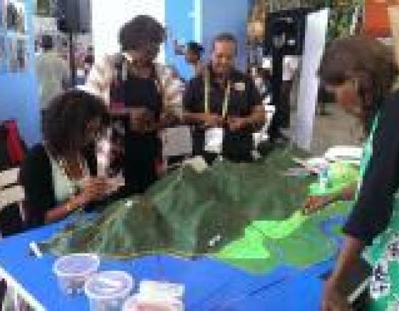
In November 2014 six Mandingalbay Yidinji representatives participated in the the 6th World Parks Congress in Sydney, Australia. During the construction phase community developed an extra 2m x 1m 'blank' that was transported by road to Sydney. MY representatives spent 3-4 days doing a live demonstration at the Congress slowly depicting their knowledge using paint, pins and wool strands, on to the blank. In addition to cultural heritage information, they also mapped boundaries such as the Wet Tropics World Heritage Area, and the Mandingalbay Yidinji Indigenous Protected Area. This live demonstration, held at the WIN and Pacific Communities Pavilion, attracted much attention and genuine interest from delegates from all over the world. The work being done by MY people created an exciting buzz around the Pavillion and drew people in to ask questions about the process and about MY traditional country. Over 250 delegates left their business cards at the demonstration seeking more information about P3DM! The demonstration was part of a wider Congress series on P3DM coordinated by the Technical Centre for Agricultural and Rural Cooperation (CTA). CTA also coordinated the attendance of P3DM practitioners from Kenya, Chad, Suriname, Samoa, Ethiopia, Trinidad and PNG. Meeting and sharing experiences with other Indigenous P3DM practitioners, and conversing with delegates from all over the world assisted MY people to understand the importance of their own experience in a global context. The WPC experience increased MY delegates confidence and their belief in P3DM as a very valuable technique. In a Congress session on the risks and benefits of mapping traditional knowledge, MY people presented the completed model back to the Congress and spoke about their experiences during the process and as Rainforest Aboriginal people. Congress Champion Mr Luvuyo Mandela attended the presentation and in a moving speech said "we, as Indigenous people need to learn a language that helps us communicate what we need and who we are in a way that’s digestible to the rest of the community. This initiative is an incredible one."

Connect with contributors
Other contributors
M'Lis Flynn
Wet Tropics Management Authority