Grenadines Marine Resource Space-use Information System (MarSIS)
Full Solution
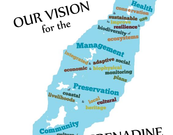
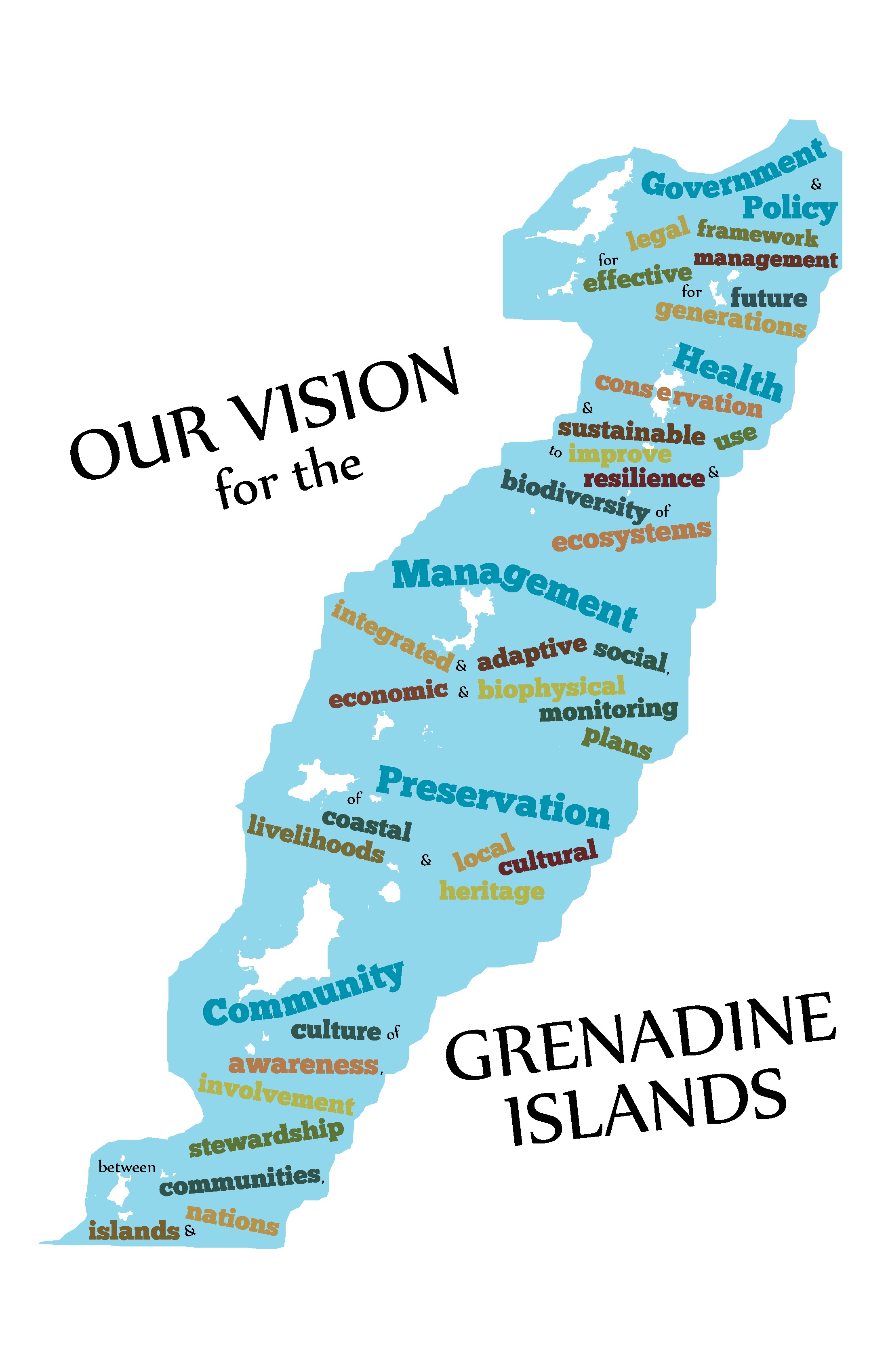
Grenadine Islands Vision Statement
CERMES
The Grenadines MarSIS illustrates how a participatory geographic information system (PGIS) approach supported the development of demand-driven information on marine resources and spatial uses of the transboundary Grenada Bank. Stakeholder engagement not only increased understanding and provided useful and publicly accessible information, but also created ownership of information produced and validated the role of participation in research and governance.
Last update: 28 Mar 2019
5134 Views
Photo and video gallery

Context
Challenges addressed
Access to information for marine spatial planning and management
- A comprehensive strategy was essential to address complex social-ecological system problems and support an ecosystem approach to marine governance. This solution engaged a diverse range of stakeholders to obtain all available sources of information; increase stakeholder understanding; and promote ownership and use of information produced to support marine spatial planning and management.
Location
St. Vincent and the Grenadines, Grenada
Caribbean
Process
Summary of the process
Ecosystem-based management highlights the need for an effective participatory framework. In this transboundary solution, we illustrate how the application of a participatory GIS approach was successful in developing an information system containing a range of data (biophysical, social, fisheries, tourism, recreation, transportation) that could be easily accessed and understood by resource users, whilst also serving the needs of decision-makers. Participatory GIS provided a platform for transparent cross-scale communication, information exchange and problem-solving. The high level of stakeholder engagement necessary for successful participatory GIS not only provided useful information, but also created a strong sense of ownership in information produced, increased understanding within and between stakeholder groups, and validated the critical role of stakeholder participation in research and governance. Furthermore, the GIS framework and its integration with other freely available easy-to-use information technology applications has provided access to information for all stakeholders that will allow continued engagement, updating and use of information for marine planning and management.
Building Blocks
Communication tools for stakeholder engagement
Stakeholder engagement was used to refine research objectives; guide methodology development; acquire/document information including local knowledge; share and validate information produced; develop locally relevant and accessible information; and appraise the application of participatory geographic information systems. To allow for transparent, inclusive and equitable cross-scale interactions, stakeholders were engaged through one and two-way communication mechanisms (newsletters, press releases, flyers, technical reports, a website, summary and validation meetings) and through a dedicated internet e-group.
Enabling factors
- The application of clearly defined governance principles was of key importance to the collaborative construction of an appropriate ecosystem-based PGIS
- A large initial investment (time and effort) to conduct a thorough preliminary appraisal was essential to appropriately design and implement the PGIS
- Periodic validation meetings not only provided quality assurance but the recurrent sharing of results showed stakeholders how information was being used
Lesson learned
Participatory geographic information systems (PGIS) resulted in the production of comprehensive and accessible information tailored to the needs of the Grenada Bank stakeholders. The PGIS process also strengthened cross-scale linkages, promoted a transparent and inclusive working environment and built capacity across a transboundary scale. Despite the overall success of PGIS in this context, there are constraints that should be considered. First, the cost of PGIS should be carefully evaluated. Accordingly the timeframe and objectives of a PGIS should be well defined and level of participation to be expected clearly elaborated before undertaking a similar endeavor. In this building block, stakeholder engagement was time-consuming, yet instrumental in fostering a collaborative work environment and creating buy-in.
Collaborative data and information gathering
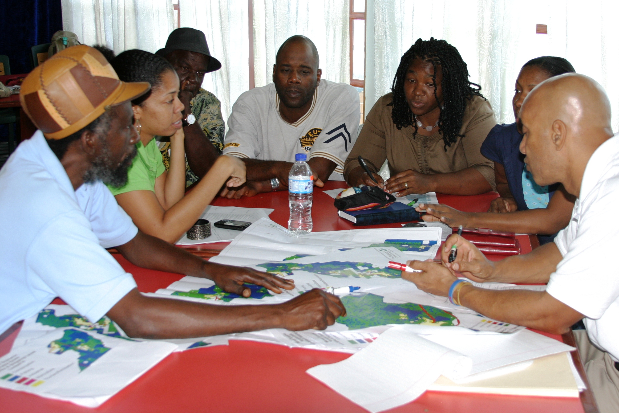
Collaborative data and information gathering was used to: identify and acquire secondary information; document local knowledge of resources and space-use; develop an appropriate habitat classification scheme; conduct marine habitat mapping field surveys; validate information produced; and ascertain the technological capacity and information preferences of stakeholders. Furthermore, participatory research demonstrates the relevance of information provided by stakeholders, strengthens capacity and provides ownership of the information produced.
Enabling factors
- The preliminary appraisal was essential to understand stakeholders’ capacity for participation and develop appropriate methods.
- Periodic validation meetings allowed for the production of accurate information based on local knowledge. This also demonstrated to stakeholders the legitimacy of their knowledge thereby promoting ownership of the information.
- Public access to information served to empower stakeholders, build capacity and cultivated a cross-scale alliance.
Lesson learned
PGIS resulted in the production of comprehensive and accessible information tailored to the needs of the Grenada Bank stakeholders. Collaborative data and information gathering served to: identify existing information; build stakeholder capacity in the understanding of the marine environment and related human uses; provide credibility to local knowledge; increase confidence and ownership in the information produced; and underscore the role stakeholders can and should play in marine governance. Communication and information exchange are important aspects of this building block and should not be underestimated. Providing access to all data, maps, and information via a public access website supported transparency and inclusiveness and served to strengthen the capacity and ownership of information by stakeholders.
Participatory GIS applications
Geographic Information Systems (GIS) applications provided a framework for effective data management and integration of information from a variety of scales and sources, thereby increasing spatial understanding of marine resources and corresponding spatial uses. The system was used to demonstrate practical GIS applications valuable for ecosystem-based decision-support and marine spatial planning. Using a participatory GIS approach supported the development of ecosystem-level GIS spatial analyses of the region to be conducted and presented in ways that increased stakeholder understanding.
Enabling factors
- GIS capacity and access to funding for GIS software, which is generally costly.
- Well identified actual problems that were of concern to stakeholders and could be addressed with the information acquired.
- Continued public access to the transboundary information produced via the research website maintained by the NGO-academic partnership
Lesson learned
The usefulness of integrating interdisciplinary information and multiple sources of knowledge for marine spatial planning is well documented, yet the actual framework and practical methodologies for acquiring holistic ecosystem-based information is lacking. We found a participatory GIS approach useful for identifying, collecting, integrating and understanding interdisciplinary information. Practical GIS analyses were applied to produce relevant ecosystem-based information. Additionally, the application of a participatory GIS approach (in terms of both information integration and visualization) proved beneficial in the conduction and presentation of information generated in ways that increased stakeholder understanding, thus supporting marine governance. Despite the overall success of participatory GIS, the maintenance of the MarSIS will require additional capacity building, particularly in terms of GIS skills.
Marine Spatial Planning
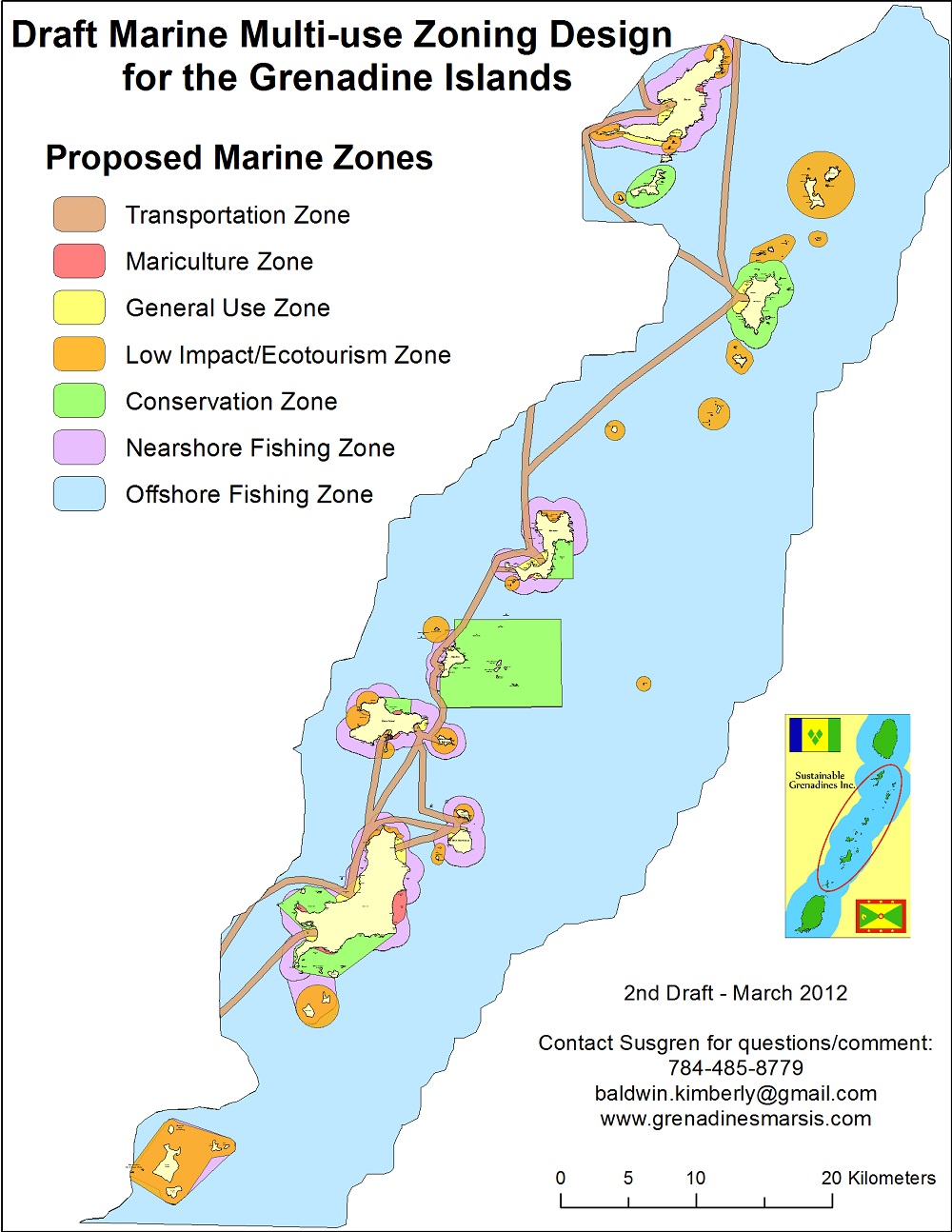
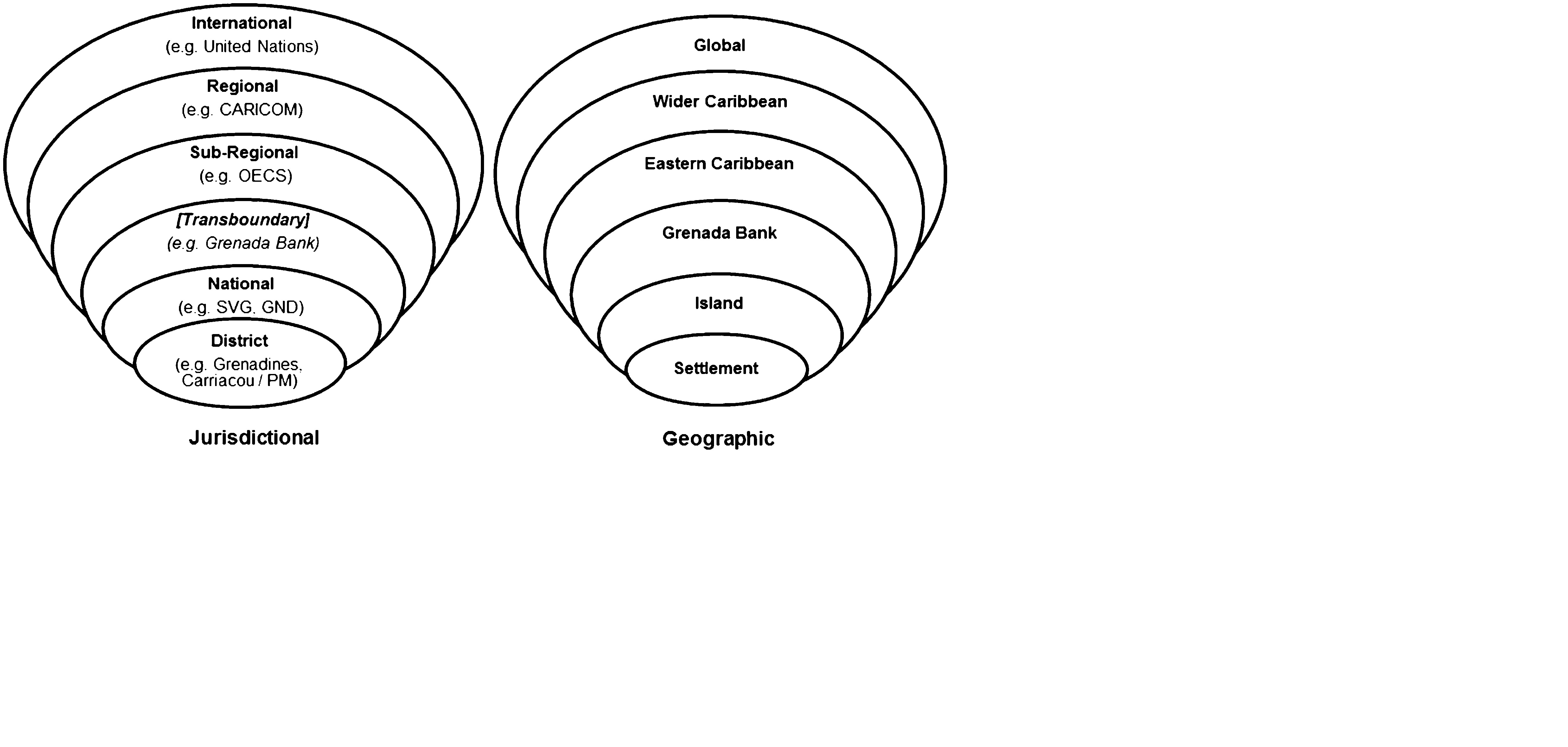
A guided marine spatial planning exercise leads to the development of a multi-use zoning design for the area. This increases the capacity to protect, manage and sustainably use the marine resources. Potential mismatches between the area’s existing jurisdictional (legal-institutional) and geographical (social-ecological) scales requires consideration.
Enabling factors
- Pre-existing cross-scale partnerships (i.e. multi-stakeholder working group) and stakeholder engagement mechanisms for communication and information exchange
- Academic-NGO partnership to address the mismatch between the existing jurisdictional (legal-institutional) scale and the geographical (social-ecological) scale
- Collaborative data collection & validation processes supported trust and ownership in MSP information
Lesson learned
GIS analyses were useful to determine the spatial allocation of the sea in a way that maximizes societal benefits and mitigates possible conflicts. Although the system was used to support transboundary MSP, inadequate sub-regional governance mechanisms constrain the implementa¬tion of the marine zoning plan by either country. Although framework legislation and national environmental management strategies are in place, formal institutional systems for national and transboundary marine management need to be clearly established. The realisation of effective transboundary cooperation and regional governance is needed to determine the appropriate and feasible institutional arrangements. Likewise, the fostering of environmental political will is essential for the development and implementation of new environmental management policies, plans and institutions.
Impacts
- Marine resource users have been exposed to the wide variety of issues affecting the marine environment and can take part in processes to address them.
- Stakeholders have experienced a variety of communication and information sharing techniques that they continue to use.
- Demand for spatial data and information has been increased as evidenced by: expansion of the study area to the main island of St. Vincent by the national government and use of the MSP to support a National Ocean Policy; use of the MarSIS by NGOs; and a joint transboundary marine World Heritage Site submission.
Beneficiaries
National governments, Non-governmental organizations, Resource users, Communities and Schools
Sustainable Development Goals
SDG 11 – Sustainable cities and communities
SDG 14 – Life below water
SDG 17 – Partnerships for the goals
Story

Grenadines MSP
Kim Baldwin
Beyond the benefits identified in the solution, a participatory approach may also facilitate improved governance by building adaptive capacity and resilience. A participatory GIS approach resulted in a broader set of ecosystem-based information than could have been obtained from conventional science sources which has been actively used by diverse stakeholders since its public release. On the international level, the United Nations Economic Commission for Latin America and the Caribbean used the MarSIS to quantify the economic value provided by reef ecosystem services in St. Vincent and the Grenadines. Subsequently, on the sub-regional level the MarSIS has been used to support: a transboundary marine multi-use zoning design for the Grenadines; a transboundary application to designate the Grenadine Islands as an UNESCO marine mixed World Heritage Site; and the Nature Conservancy’s ‘At the Water’s Edge: Coastal Resilience in Grenada and St. Vincent and the Grenadines’ project. Nationally, the planning departments of both countries regularly use the MarSIS to check the validity of environmental impact assessments submitted to the government. Locally, two NGOs have used the MarSIS to contest environmentally unsustainable coastal development projects to show the potential impacts of a dredging and sand reclamation project in Canouan, and to rally against a proposed freeport development in Carriacou. Additionally, Grenadine school teachers have developed environmental curricula based on the use of MarSIS in Google Earth. These examples substantiate the importance of connectivity for learning systems to empower stakeholders to participate in governance.
Connect with contributors

Other contributors
Dr. Kimberly Baldwin
Centre for Resource Management and Environmental Studies (CERMES), of the University of the West Ind
Prof. Robin Mahon
Centre for Resource Management and Environmental Studies (CERMES) of the University of the West Indi
Dr. Patrick McConney
Centre for Resource Management and Environmental Studies (CERMES), of the University of the West Ind
Prof. Hazel Oxenford
Centre for Resource Management and Environmental Studies (CERMES), of the University of the West Ind