Using monitoring data to create protected areas and wildlife corridors for saiga conservation
Full Solution

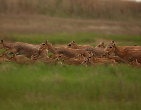
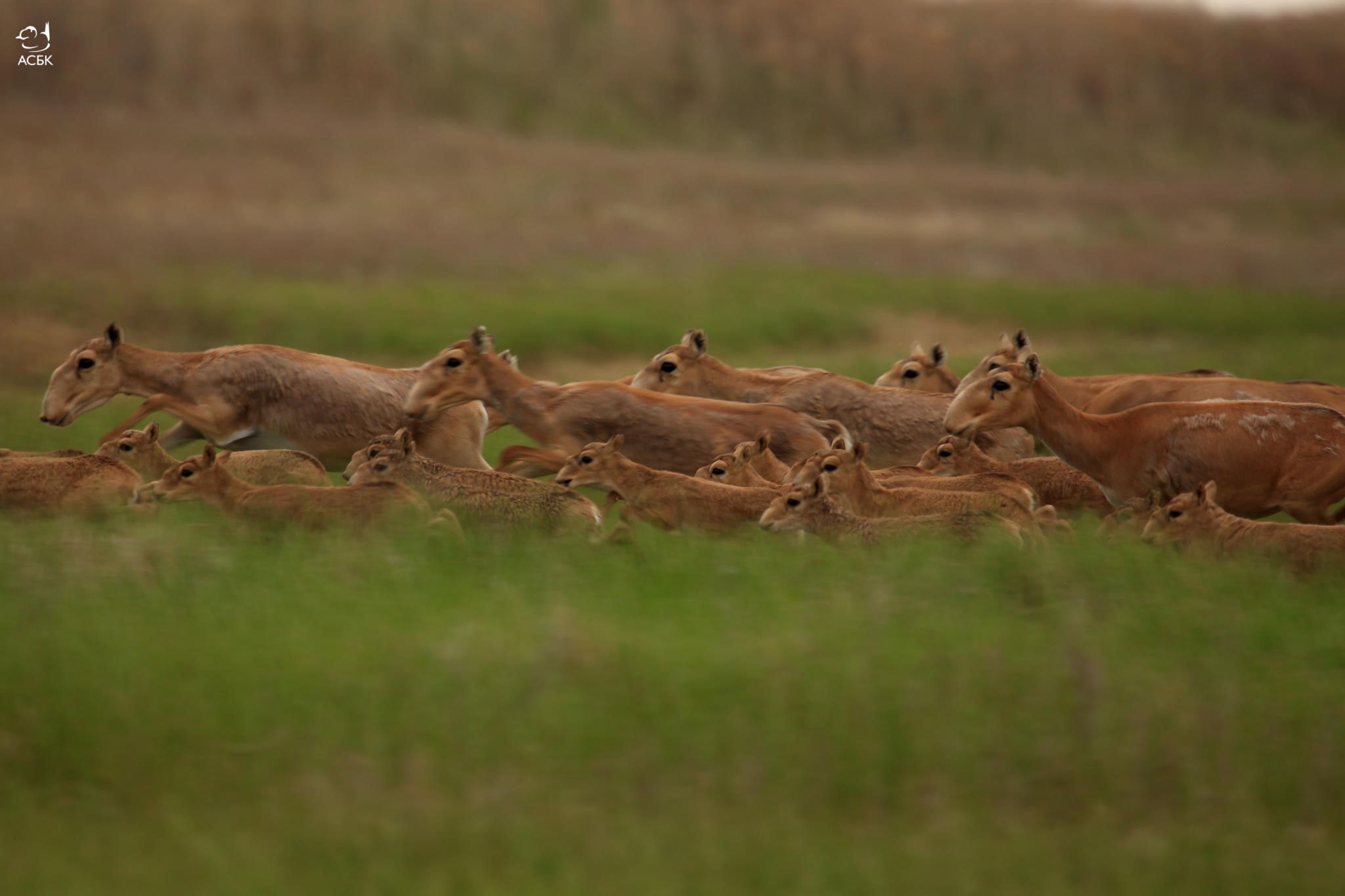
Saiga on the move
Albert Salemgareyev/ACBK
The Altyn Dala Conservation Initiative (Altyn Dala) project aims to establish a network of protected areas within the historic boundaries of the Betpak-Dala saiga population to effectively protect saiga, their endangered steppe and semi-desert habitat, and other flagship species including great bustards and sociable lapwing. Once completed, this network of protected areas is anticipated to cover 3 to 5 million hectares.
To gather data on saiga's migrations and help inform the national authorities on the need to design and establish new protected areas and ecological corridors, the experts are relying on the information collected with the help of satellite collars - as it allows the experts to understand the long-term impacts of infrastructure developments on saiga movements and population recovery.
Last update: 30 Sep 2025
2859 Views
Photo and video gallery
Context
Challenges addressed
The first challenge faced was the lack of a management plan. One of the priorities of the Altyn Dala Conservation Initiative is the efficient management of protected areas. The Altyn Dala Reserve, which aims to protect the calving and migration areas of the Betpak Dala saiga population, had no official management plan, so a seminar was held to develop one.
The second challenge was related to the capacity to carry out the monitoring: training courses for state inspectors and scientific researchers on using GPSs, collecting monitoring information and entering the data into a recently improved database were also held.
The third challenge identified was poaching. The project was also developed to support anti-poaching activities in the Altyn Dala and Irgiz Turgay State Nature Reserves, to improve conditions for state rangers at reserves and their anti-poaching effectiveness.
Location
Yrgyz, Yrgyz District, Aktobe, Kazakhstan
North and Central Asia
Process
Summary of the process
Once analyzed, the information collected with the help of satellite collars allows the experts to understand the long-term impacts of infrastructure developments on saiga movements and population recovery. As a next step, the use of the saiga as flagship species facilitates the message of conservation and protection shared with the communities and helps inform the national authorities and decision-makers on the need to design and establish new protected areas and ecological corridors.
Building Blocks
Satellite tagging
Saigas migrate across several million hectares. To map their use of the steppe grassland, the experts have successfully fitted satellite transmitters to over 40 saiga antelopes. As a result, they were able to detect their major migration routes, and calving and wintering areas.
Enabling factors
It is essential to secure the funding for the equipment, the participation of the experts trained in collar fitting as well as the support and approval of the government to conduct the research.
Lesson learned
It is key to have the national authority's support and participation and make sure that the government knows what data is acquired and how it will be used.
Using a flagship species to catalyze policy changes
In this case, the saiga is used to catalyze this incredible protection initiative which also aims to re-establish self-sustaining populations of other original large steppe grazing herbivores - Przewalski’s horse, kulan and goitered gazelle as well as understand the role of the ‘steppe’ wolf in maintaining healthy populations of saiga antelopes and to ensure that all these areas, their rich wildlife and local communities can be sustained economically in the long term.
Enabling factors
The key enabling factor for this is a tremendous partnership between multiple conservation organizations and the Government of Kazakhstan, which has always viewed this project as a long-term process.
The initiative is implemented by the ACBK with the support of the Committee of Forestry and Wildlife of the Ministry of Agriculture of Kazakhstan, Fauna & Flora International, Frankfurt Zoological Society, and the Royal Society for the Protection of Birds, and it complements the work of the national authorities.
Lesson learned
The saiga experienced a massive die-off in 2015. Climatic conditions transformed a usually harmless bacterial infection into a dangerous outbreak that killed more than 60% of the saiga antelope. More than 200,000 saiga antelope died of a virulent infection over a 3-week period. A bacterium (Pasteurella multocida) was identified as the cause which caused extensive internal bleeding. The bacterium does not typically harm healthy saiga, which suggested that an environmental factor might have made the microbe more dangerous. The team analysed weather data from 1979 to the mid-2010s, a period that included three mass die-offs of saiga — in 1981, 1988 and 2015. They found that the outbreaks were linked to relatively high daily temperatures and humidity levels.
Careful management is needed to protect the remaining populations of this critically endangered species, especially in the face of climate change
Community outreach
With poaching being a huge threat to saiga, especially given the demand for saiga horn in the illegal wildlife trade, outreach plays a very important role. ACBK holds every year in May the “Saiga Day” together with the Saiga Conservation Alliance, in which members of the steppe clubs participate in games, crafts, competitions and other educational and entertainment programs.
Enabling factors
Participating communities and schools.
Lesson learned
The outreach creates support for saiga conservation in neighbouring communities. Led by ACBK, the partnership is working to educate the local population about the threats to nature and the necessity of its conservation. A special monitoring group that was created regularly conducts outreach campaigns about the illegality of the saiga horn trade among the rural population. They are raising awareness of the youth living in key settlements located in the area of each saiga population to gain deeper knowledge about this species, and mobilise them around the 10 formed clubs of “Saiga Friends” in Kazakhstan. Unemployment forces many local people to poach. The clubs teach the children the important role of each species and the consequences that poaching of wildlife may have on the whole ecosystem.
Impacts
The saiga (Saiga tatarica) is a migratory ungulate that exists in two subspecies and five major populations: three in Kazakhstan, one in Russia and one in Mongolia. More than 2 million existed in the 1950s, but catastrophic declines since the 1990s resulted in only 30,000 remaining, scattered across an immense area. Originally hunted for meat, in the 1990s the population declined dramatically due to ruthless hunting for horns to satisfy demand from China, where saiga horn is used as traditional medicine. Only hundreds persist in Altyn Dala, where historically the largest population of 1 million thrived, as it was both a calving ground and provided rich summer grazing.
Project partners support mobile warden units whose patrols investigate and deter poaching, and monitor the migrating herds. This is combined with law enforcement, public awareness and socio-economic development to make poaching a far less attractive option for rural people. The use of satellite transmitters has highlighted saiga's major migration routes, as well as vitally important calving and wintering areas. By combining this information with the results of biodiversity and socio-economic surveys and overlapping the data with the current protected areas network, the experts could identify new areas for protection.
Beneficiaries
The beneficiaries of this solution were the wildlife and local communities in and around the project area.
Sustainable Development Goals
SDG 15 – Life on land
Story
 and Munib Khanyari measure a newborn saiga")
Albert Salemgareyev (ACBK) and Munib Khanyari measure a newborn saiga
M.Khanyari
Altyn Dala is one of the most ambitious and breathtaking species and habitat conservation projects. The steppes are of global importance, and one of the least protected habitats in the world. They support a huge diversity of wildlife including the saiga antelope. Most activities focussed on the Irgyz-Turgai-Zhylanshyk pilot area which covers 5 million ha and encompasses the former range of the Betpak-Dala saiga antelope population, the largest in Kazakhstan. Over one million of these animals formerly grazed the grasslands maintaining a rich mosaic of vegetation. Heavy poaching in the 1990s brought them to the edge of extinction with perhaps less than 30,000 surviving, followed by a massive die-off in 2015. But the trend is since positive.
However, conserving saiga antelope is not simple. Each year they migrate across several million hectares - declaring all as protected areas was clearly impractical. Therefore, the Initiative applied a landscape-scale approach to conservation. To understand the migrations, ACBK has successfully fitted satellite transmitters to over 40 saiga antelopes and as a result, has mapped how they use the steppe grassland. This has highlighted their major migration routes, as well as vitally important calving and wintering areas. By combining this information with the results of biodiversity and socio-economic surveys and overlapping the data with the current protected areas network, ACBK has been able to identify new areas for protected area designation.
Based on these recommendations, a new protected area was established in 2012 – the Altyn Dala State Reservat covering 489,776 ha – and the Government announced its intention to extend the Irgyz-Turgai State Reservat by 410,000 ha. Of even more significance, though, is that ACBK has been able to identify land suitable for an ecological corridor to link these two Reservats to provide safe migration routes for saiga antelopes and other wildlife. The 'Yrgyz-Torgai-Zhylanshyk’ wildlife corridor was officially declared by the Government in July 2014, as the first-ever ecological corridor in Kazakhstan. The area now under protection is 3.67 million ha and consists of a combination of state-protected areas, commercially managed hunting areas and privately managed land, each with their own management objectives and activities.
Connect with contributors


Other contributors
Tatjana Rosen
Center for Large Landscape Conservation
Stephanie Ward
Frankfurt Zoological Society