At the water’s edge: Enhancing coastal resilience in Grenada
Full Solution
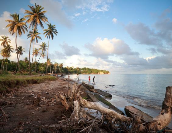
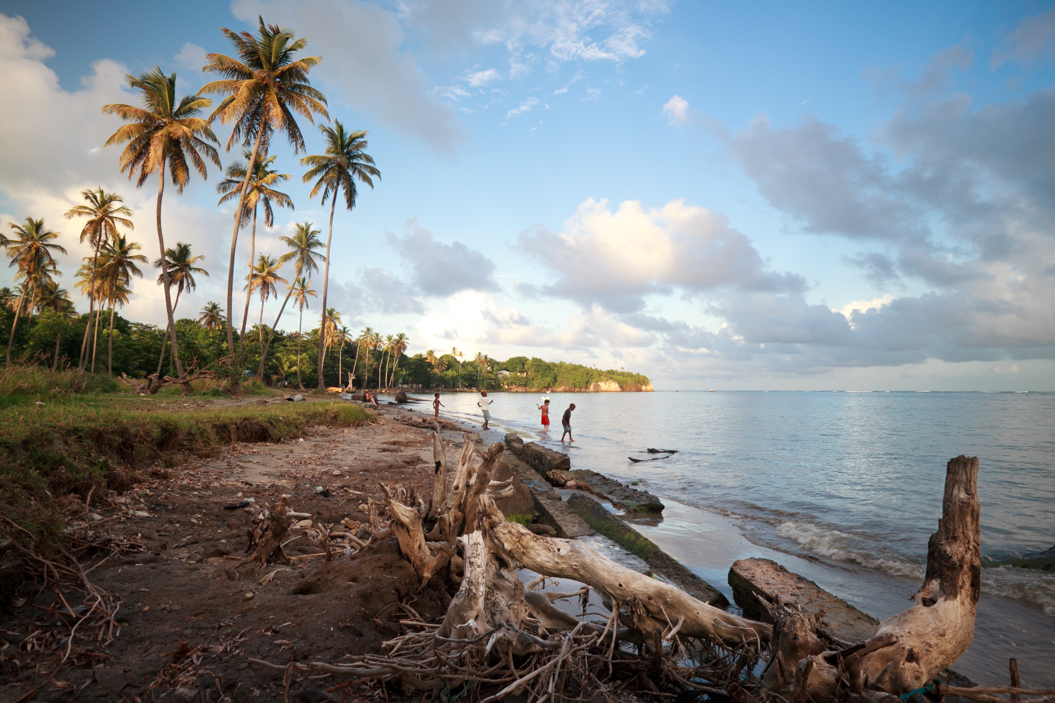
Coastal erosion at Telescope Bay in Grenada.
Marjo Aho
At the water’s edge addresses the problem of increased coastal erosion and flooding, and vulnerability to fishers and coastal communities, due to climate change impacts to the small island state of Grenada. The project builds social and ecological resilience, with strong community engagement, through the implementation of nature based solutions including the installation of artificial reef structures to attenuate wave energy, restoration of coastal vegetation, and community resilience planning.
Last update: 08 Feb 2023
11361 Views
Photo and video gallery
Context
Challenges addressed
• Coastal erosion and flooding due to increasing sea level rise and storm surge. • Degrading reefs that are losing capacity to protect coastal communities. • Lack of social cohesion. • Limited community ability to respond and adapt to impacts from climate change. • Lack of nature based solutions for coastal protection in small island states that provide for improved ESS and can be implemented by the community.
Location
Grenada, Caribbean
Caribbean
Process
Summary of the process
The main building blocks listed above, along with others, played an integral part in assisting communities to solution-ize various issues faced as a result of climate change. Mapping and visualization (P3DM) were key to understanding the opportunities and challenges faced within the communities while documenting and taking advantage of the local knowledge. Said visualization and mapping paved the way for community members to engage in the integrated assessment which was pivotal in moving the project forward. The assessment served as a vehicle to: capture a range of socio-economic and ecological issues, supplement climate and disaster management in country-databases, and build critical relationships with implementation partners and community members. The reef enhancement block, developed in an area identified as in need for risk reduction measures via the vulnerability assessment process described above, is designed to achieve various risk reduction benefits: coastal protection as well as increased community adaptive capacity (see description of impacts for details).
Building Blocks
Climate change impact visualisation
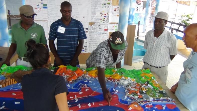
Visualizing potential impacts is a powerful tool to help communities understand their vulnerabilities and consider future scenarios and tradeoffs. This is important to motivate changes that need to be made to reduce a community’s risks and support decision making around climate and disaster risk management. Computer based maps are not always the most effective means of communication. At the national scale we developed a suite of visualization tools for technical persons that included web-based maps and electronic and hard copy maps. At the local scale we worked with local partners Grenada Fund for Conservation and Grenada Red Cross to engage communities through household surveys and Participatory 3D Mapping (P3DM). These tools allowed us to integrate the knowledge and perspectives of nearly 400 community members, generate site level vulnerability assessments and visualization tools. To help facilitate community input and visioning, we also partnered with a land-use planning firm. Using the design firm’s strong graphic facilitation skills, a visual representation of a number of climate change impacts and associated potential actions that would contribute to Grenville Bay’s climate resilient Grenville bay was generated.
Enabling factors
• Community understanding the importance and the benefits of a successful implementation.
• Community acceptance, participation and ownership.
• Government involvement and participation.
• Partnerships with the Grenada Red Cross and NGO Grenada Fund for Conservation (mobilizing communities, empowering stakeholders, ensuring the development of an action plan for climate adaptation).
• Access to data on climate change impact (via local knowledge and/or quantitative model predictions).
Lesson learned
• The site level process described above was critical for the development of several targeted locally relevant proposals.
• Applying a participatory process empowered community participation critical for the selection of locally relevant options that best align with a community’s vision of desired current and future outcomes.
• Partnering with a variety of groups (engineers, land use planners, and local NGO’s like the RC and GFC) greatly facilitated the integration of diverse knowledge and consideration of a suite of options that will help communities and decision makers chose an informed path forward. Building capacity and working at pilot sites with communities takes a significant commitment of time and resources.
• Participatory 3D mapping is a powerful tool for gathering community knowledge and stimulating discussion, and it also requires trained facilitators and community mobilization to implement.
Integrated vulnerability assessment (VA)
We developed a spatially explicit vulnerability analysis that included both national and local indicators. These indicators were designed to capture the social, economic and ecological vulnerabilities and the interplay between them. The framework used to organize the indicators captured exposure, adaptive capacity, and sensitivity of three key social components (critical infrastructure and facilities; livelihoods -i.e. natural resource dependence and critical industry facilities such as fish processing plants and hotels- and social sensitivity -number of people and houses) as well of critical coastal habitats (mangroves, seagrass and reefs) providing risk reduction services (e.g. coastal protection and provisioning). Layering the ecological vulnerability assessment with the socioeconomic vulnerability assessment highlighted areas of overlap where adaptation and disaster risk reduction interventions were most needed, and where nature could play a role in reducing climate and disaster risk. The national level assessment framework was then adapted for site scale application to produce a community vulnerability assessment.
Enabling factors
• Community understanding the importance and the benefits of a successful implementation.
• Community acceptance, participation and ownership.
• Government involvement and participation.
• Partnerships with the Grenada Red Cross and NGO Grenada Fund for Conservation (mobilizing communities, empowering stakeholders, ensuring the development of an action plan for climate adaptation).
• Access to information on socio-economic and ecological characteristics.
Lesson learned
• The critical role that partnerships and community engagement play during all stages of the Project.
• The importance of engaging relevant government agencies and others early on to ensure: a) that the analysis is grounded in local context and needs; b) that information and data collected are accurate and current and can be effectively utilized by government agencies.
Informed Decision Making
Access to pertinent and best-available information is important for informed decision-making, yet coordination between government agencies and other data collection and management organizations can be stymied by lack of resources and inconsistent mandates. To address this gap, The Nature Conservancy (TNC) has invested in connecting agency departments with other local, regional and international organizations that contribute to data production and/or management relevant to risk reduction and adaptation planning. Working closely with the Grenada Statistics Department, TNC developed a coding system that allows census survey data to be linked with spatial representations of survey districts and made unrestricted information freely available through an online platform. To support data access, co-management, and use, the AWE project in partnership with the World Bank contributed to the development of holistic databases and critical training of government technical staff. This partnership makes non-confidential information available via a centralized system and helps decision-makers access integrated spatial information on ecological, social, and economic systems.
Enabling factors
• Involvement of and participation of Government Ministries and Departments in the project processes.
• Effective partnerships with other organizations (e.g. World Bank) and government agencies.
Lesson learned
• The importance of understanding dynamics of organizations and agencies as it relates to information sharing.
• The importance of prioritizing clear communication about the project with partner agencies to ensure that project aims, objectives potential benefits are fully understood.
• The importance of strong partnerships.
Reef enhancement for coastal protection
While sea walls, boulders, and other hard approaches to coastal protection are the right approach in some areas, they are also very expensive, high maintenance, and destructive to the living shoreline we all treasure. Nature-based solutions seek to integrate built structure, natural systems such as reefs, beaches, mangrove and coastal woodlands, and forests. Nature-based solutions are often much cheaper, and also provide greater benefits such as food production and beautiful places for people to recreate.
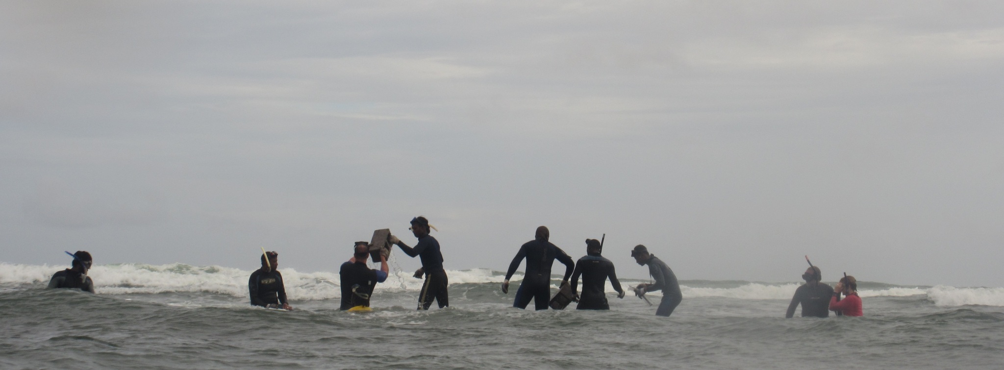
This project seeks to install reef structures designed to provide fish and coral habitat, and break wave energy and ultimately reduce coastal erosion and flooding. The design phase included detailed measurements of the seabed, wave energy modeling using data from the past sixty years, and coastal engineering. Local labor and equipment was used to install a first set of structures. The installation took a total of three weeks and constitutes one of TNC’s most important pilots to test nature based solutions to climate change.
Enabling factors
• Community understanding the importance of and the benefits to be derived from the successful implementation of the project.
• Community acceptance, participation in the project process and ownership of the project.
• Involvement of and participation of Government Ministries and departments in the project processes.
• Partnerships with the Grenada Red Cross and NGO Grenada Fund for Conservation and other community groups that assisted with mobilizing communities and empowering stakeholders.
Lesson learned
• Community engagement and buy-in at all stages, as well as partnerships with local organizations and community groups, was critical for successful implementation.
• Accuracy of bathymetry data available (we used satellite derived data but this lead to inaccuracies and delays during installation; access to LIDAR (Light Detection and Ranging) data would have been ideal).
• Given the experimental nature of this block phasing of installation was critical.
• Employing a local commercial dive operator and local divers was critical, during installation since the commercial diver’s experience and the divers’ knowledge of local context has been invaluable.
Impacts
• Social: increased social cohesion amongst community members; working together to increase their resilience, protect their homes and in some instances livelihoods. Increased awareness of environmental issues affecting communities, the steps needed to provide replicable solutions to issues.
• Economic: creation of training and employment opportunities for community members during various stages of project planning, implementation and subsequent monitoring. Skills and knowledge are transferable to projects of a similar nature on or off island.
• Ecological: installation of reef structures will provide additional shoreline protection needed for vegetation to thrive, while also providing habitat and reef functions.
Beneficiaries
Coastal communities of Grenville and other coastal communities in Grenada, the government of Grenada and the agencies involved in coastal zone management and climate change adaptation, other small island developing states with similar circumstances.
Story
Nealla Frederick – Project Manager for "At the water’s edge":
"When I was a child I remember going to Grenville and picnicking with my family on the wide sandy beach in the area known locally as Telescope. For generations Telescope Beach has served as a key recreational area for residents of the northern part of Grenada.
Twenty years on, in 2013, I was the first Grenadian ever hired to work with The Nature Conservancy, and my first major assignment was to work on coastal ecosystem based adaptation and the Conservancy’s pilot project in Grenville Bay. My first visit back to Grenville shocked me. As I walked along the shore in Telescope nothing looked the same. The beach where I had played as a child and all coastal vegetation had been lost to the sea. One of the elders in the village told me of their fight with the sea and how their only solution was to pile tires, stones, blocks, and old engine blocks along the shore. It was sobering to think that I could do anything to help.
I can now honestly say that over the past two years things are changing for the better and I know we are making a difference. Working together community members, government, and Conservancy scientists and coastal engineers are implementing blue solutions that are based in science and supported with local knowledge. In January, the pilot installation of reef enhancement structures designed to break wave energy and provide habitat was completed. The structures were constructed, assembled and installed utilizing local labor and resources.
Divers were out all day placing rocks into wire baskets and stacking them together like giant Legos. Work in the high surf zone was difficult and dangerous, but crew made up of local spear-fishers was used to these conditions. During a short break I spoke with one of them about his feelings about the project. His response made all my months of hard work and frustrations worthwhile. He told me that for the first time in many years he had hope for the future of his community. He could see that the structures were already breaking waves as designed, and that he was satisfied that the project was guided by local knowledge and used local labor. He had already seen the fish, octopus and lobster moving onto the structure, and said that his community was embracing the project as their own and were now committed to become better stewards of their environment, knowing that by caring for nature, nature would care for them."