Un outil dynamique pour la gestion intégrée de l'eau et de l'utilisation des sols
Solution complète
Proyecto C6 Conservación de cuencas costeras
Fondo Mexicano para la Conservación de la Nauraleza, A.C.
Un outil intégré, dynamique et opérationnel de planification de l'utilisation des terres et de la gestion de l'eau a été créé par le biais d'une alliance interinstitutionnelle pour la conception, le développement et la mise en œuvre de "plans d'action pour la gestion intégrée des bassins hydrographiques" (PAMIC, selon l'acronyme espagnol). Sa vision est innovante, utilisant l'eau comme un élément conducteur dynamisant les différentes unités de gestion du bassin. La modélisation des services hydrologiques (c'est-à-dire le potentiel de rétention des eaux de surface et des sédiments) permet d'identifier les zones de demande et d'offre et de les relier grâce à la collaboration des acteurs du bassin hydrographique. En outre, un système de financement permanent a été créé et mis en œuvre pour garantir la poursuite des actions du projet par les administrations gouvernementales suivantes.
Dernière modification 26 Mar 2021
8557 Vues
Galerie de photos et de vidéos
Contexte
Défis à relever
- Compte tenu des changements inévitables dans la politique et l'administration du gouvernement, qui ont lieu après chaque élection présidentielle de six ans, il est fondamental de trouver des moyens de s'assurer que l'instrument de planification, PAMIC, peut transcender ces cycles et continuer à être mis en œuvre par le gouvernement suivant à différents niveaux.
- Pouvoir maintenir le soutien et le fonctionnement de l'instrument de planification, PAMIC, par l'intermédiaire des organisations de la société civile et des différents niveaux de gouvernement afin de garantir que PAMIC soit sauvegardé et utilisé pour soutenir la prise de décision dans différents scénarios et dans davantage de régions du Mexique.
- Trouver des ressources suffisantes pour augmenter le nombre de bassins fluviaux pouvant bénéficier de la mise en œuvre d'un PAMIC.
Emplacement
Cuencas del Golfo de México, Mexique.
Amérique du Nord
Traiter
Résumé du processus
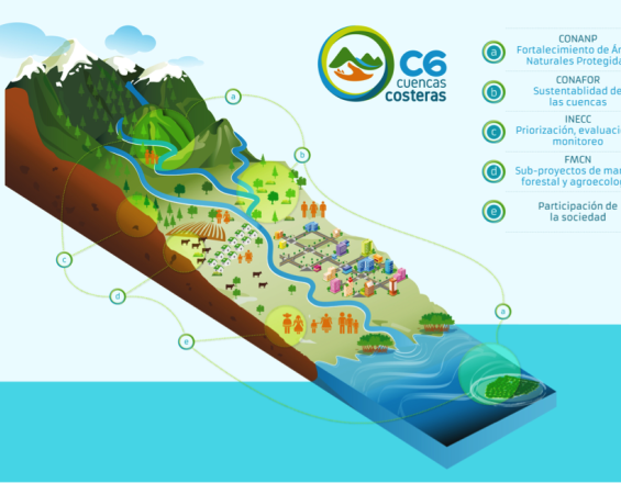
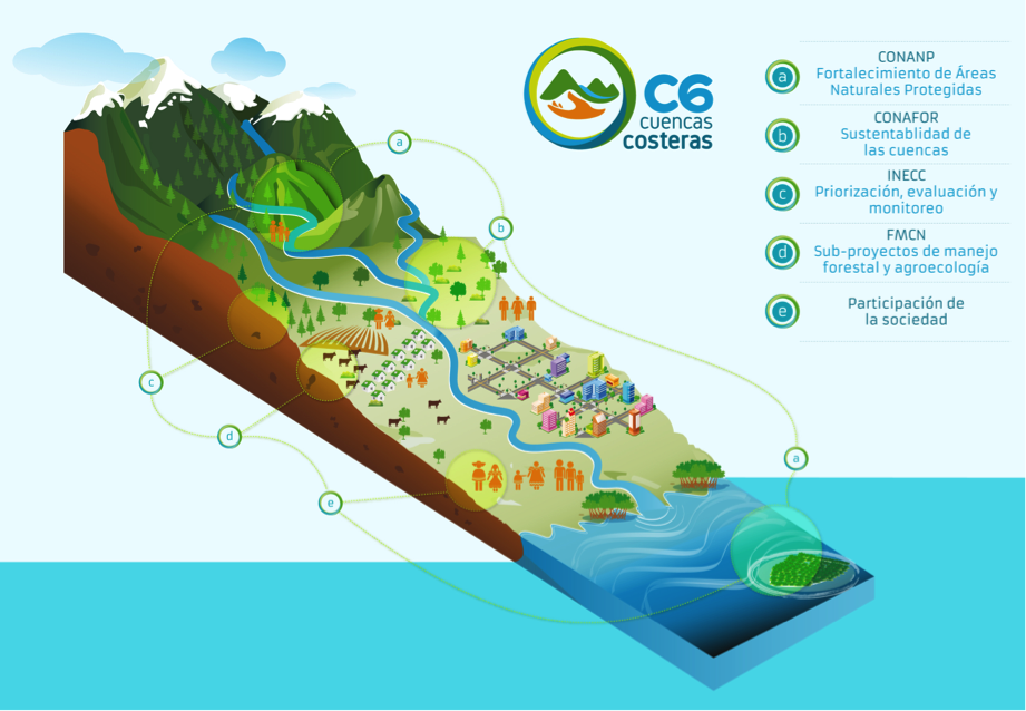
L'eau est au centre de PAMIC - l'eau est l'élément conducteur qui réunit les différents acteurs. Le bloc II "Créer une vision commune de la gestion des terres par l'eau" établit ces liens en faisant correspondre la demande de services hydrologiques des gestionnaires de l'utilisation des terres avec l'offre de ces services par le bassin hydrographique. Ce bloc fournit à son tour une incitation pour le bloc III "Les éléments clés de la conservation des écosystèmes sont également anthropiques". Il vise à faire comprendre aux parties prenantes que les écosystèmes durables ont besoin de communautés durables qui en vivent et qui, par conséquent, en prennent soin. Le bloc IV "Soutien des institutions locales et des organisations de base", qui coordonne le soutien vital des organisations non gouvernementales (ONG) et des organisations de la société civile (OSC) locales dans l'accompagnement à long terme des communautés locales, soutient ces deux blocs à partir de la base. Enfin, le soutien descendant est assuré par le bloc I "Gouvernance interinstitutionnelle à différents niveaux", qui fournit le cadre de soutien institutionnel dans lequel l'ensemble de la solution peut fonctionner.
Blocs de construction
Gouvernance interinstitutionnelle à différents niveaux
Pour créer et développer le PAMIC, diverses entités gouvernementales appartenant au secteur de l'environnement ont uni leurs forces pour concevoir un projet novateur et d'avant-garde : l'Institut national de l'écologie et du changement climatique (INECC) a coordonné la construction des plans du PAMIC ; la Commission nationale des zones naturelles protégées (CONANP) a consolidé la gestion et l'exploitation du projet au sein des zones naturelles protégées (ANP) ; et la Commission nationale des forêts (CONAFOR) a mis en œuvre des systèmes de paiement pour les services environnementaux à partir du fonds pour la biodiversité. Le Fonds mexicain de conservation de la nature (FMSN) a apporté son expérience en matière de gestion des programmes de financement. Dans l'ensemble, cela a permis de créer deux fonds supplémentaires pour stimuler les activités et les impacts. En outre, la coordination interinstitutionnelle comprenait i) un comité de projet technique qui a supervisé et dirigé le fonctionnement du C6 ; ii) un coordinateur de projet de l'unité et iii) deux unités de projet régionales, responsables de la coordination quotidienne des questions techniques et logistiques. Cette conception a été un aspect essentiel qui a généré des avancées majeures dans la planification de l'utilisation des terres pour des bénéfices collectifs.
Facteurs favorables
- Très bonne coordination entre les institutions, qui partagent toutes une vision claire de l'utilisation des différents instruments financiers et de gestion ;
- Ressources financières et institutionnelles suffisantes ;
- L'expérience et l'intérêt des institutions impliquées ;
- Expérience dans la mise en œuvre de programmes existants, par exemple les programmes d'aide sociale, les subventions, les paiements pour services environnementaux, etc.
Leçon apprise
- Les efforts de coordination bénéficient de formes de gouvernance polycentrique entre les niveaux et les parties prenantes. Ce schéma de gouvernance est soutenu par des accords formels entre institutions qui établissent de manière transparente les règles du jeu pour toutes les autres organisations et parties prenantes impliquées dans le projet.
- Les accords institutionnels formels peuvent produire un instrument de planification dynamique et renforcer la prise de décision, en aidant chaque partie prenante à tirer le meilleur parti des différents éléments de planification pour la gestion de l'utilisation des terres.
- La confiance des institutions clés dans les processus de planification de l'utilisation des terres à l'échelle locale s'est accrue de manière visible. Cela se traduit par une amélioration de la prise de décision et de l'utilisation des fonds du programme.
Créer une vision commune de la gestion des terres grâce à l'eau
Afin de promouvoir une connectivité opérationnelle entre les différents sous-bassins (zones) amont et aval d'un bassin fluvial, y compris les écosystèmes et les activités productives, l'eau a été choisie comme élément conducteur, c'est-à-dire comme élément permettant de réunir les zones et les parties prenantes. La modélisation de l'approvisionnement en eau de surface et de la rétention des sédiments dans différentes zones a permis d'identifier les relations fournisseur-bénéficiaire-accumulation. Ainsi, la dynamique entre la demande de services hydrologiques (par exemple, les populations, les zones touristiques) et ceux qui les produisent (les zones montagneuses avec un couvert forestier) a pu être identifiée et reliée. Sur cette base, les différentes parties prenantes ont été réunies pour apprendre et échanger des informations clés sur les niveaux zonaux de production et les services disponibles. Cela a permis d'identifier ce qui devait être fait, où et par qui.
Facteurs favorables
- Un réseau d'ONG ayant suffisamment d'expérience pour encadrer les producteurs et les autres parties prenantes ;
- La disponibilité de matériel et de méthodes d'enseignement de qualité utilisables par et avec les communautés ;
- L'engagement et l'intérêt des différentes parties prenantes et des institutions gouvernementales pour l'ensemble du projet.
Leçon apprise
La connectivité intrinsèque de la méthodologie PAMIC s'est avérée être l'aspect qui attire l'intérêt des entités gouvernementales et des parties prenantes de l'utilisation des terres. L'outil permet d'identifier les personnes avec lesquelles ils peuvent travailler dans le cadre d'activités productives (par exemple, la production de café ou de sucre). Cet aspect a permis aux acteurs locaux en tant que groupe de comprendre la dynamique entre les unités de micro-bassin versant.
Les éléments clés de la conservation des écosystèmes sont également d'ordre anthropique.
Dans le cadre de PAMIC, une grande attention est portée à la dynamique de la transformation du paysage. On tente d'identifier et de conserver les éléments qui sont essentiels à la conservation des écosystèmes, qu'ils soient d'origine naturelle ou anthropique. Dans la philosophie de PAMIC, la conservation ne signifie pas le maintien d'écosystèmes vierges. Au contraire, la conservation comprend la restauration des paysages gérés et l'utilisation de pratiques durables. Cela permet de maintenir l'ensemble du système socio-écologique grâce à une utilisation durable de la terre, comme le démontrent les projets de production de café sous ombrage, d'agro-sylvo-pastoralisme et de gestion communautaire des forêts, qui soutiennent à la fois les moyens de subsistance et les écosystèmes.
Facteurs favorables
- Confiance dans les avantages sociaux et environnementaux de la gestion communautaire durable
- Apprentissage institutionnel des limites à long terme de la vision "ne pas toucher" de la conservation comme moyen de préserver les écosystèmes ;
- Réseau d'acteurs ayant des connaissances sur l'utilisation des terres et la gestion de l'eau
- Encadrement à long terme des producteurs ;
- Il est essentiel d'utiliser les coopératives locales existantes pour générer, diriger et gérer l'introduction de nouvelles approches dans les activités productives existantes.
Leçon apprise
- Lorsque les communautés ont le sentiment que leurs activités productives ne sont pas menacées, elles sont plus disposées à s'impliquer et à entreprendre des initiatives auto-organisées pour la gestion durable des écosystèmes.
- De même, lorsqu'elles considèrent le projet comme une opportunité d'obtenir un soutien et un financement éventuel pour améliorer leurs activités productives, l'engagement et l'intérêt pour la gestion durable de l'écosystème augmentent.
Soutien des institutions locales et des organisations de base
Le coordinateur de l'unité de projet a formé une alliance avec les gouvernements locaux, les centres de recherche et les organisations de base ayant une présence spécifique dans chacun des bassins du projet. De cette manière, une communication efficace avec les producteurs et les autres acteurs du territoire a pu être assurée. Grâce au réseau d'ONG locales, les ateliers d'information et de présentation des résultats ont eu un impact important et ont permis de traduire plus efficacement les idées des parties prenantes en solutions pratiques sur le terrain. Parmi les exemples de ce soutien sur le terrain, citons : i) la gestion des différents intérêts et des conflits potentiels entre les acteurs de la centrale nucléaire de Cofre de Perote ; ii) la connexion des programmes gouvernementaux d'aide sociale, des subventions, etc, aux zones du bassin hydrographique qui coïncident avec le projet, ce qui a permis de créer des synergies utiles ; iii) l'établissement de lignes de travail coordonnées entre le gouvernement, les zones naturelles protégées (PNA) et les OSC ; iv) la coalition entre les OSC a eu un impact sur le bassin hydrographique et sur la réduction des coûts, en utilisant de manière complémentaire les différentes capacités des acteurs impliqués.
Facteurs favorables
- Un réseau d'ONG suffisamment expérimentées pour offrir une formation pratique aux producteurs ;
- Des niveaux existants d'organisation des communautés, des producteurs et des autorités locales sur lesquels construire des initiatives, par exemple des assemblées d'ejidos, des coopératives de pêche, des unités de production rurale, etc ;
- Un sentiment d'identité et d'appartenance partagé par les producteurs, les communautés et les autorités locales.
Leçon apprise
- Il a été essentiel de disposer d'un réseau d'organisations de la société civile qui collaborent au projet et contribuent à promouvoir les bonnes pratiques dans le bassin hydrographique.
- Chaque bassin étant différent, le fait d'avoir des OSC et des ONG locales comme partenaires du projet a permis de mieux adapter les activités du projet aux caractéristiques de chaque communauté ou zone.
- Il est toutefois essentiel d'assurer une bonne gestion et une bonne coordination du réseau des OSC/ONG afin de garantir que tous les acteurs concernés sont au courant des activités de chacun.
Impacts
- La coordination interinstitutionnelle entre les principales entités gouvernementales du secteur de l'environnement et les ONG nationales et internationales, ainsi que les groupes communautaires, a renforcé les voies de la coopération interinstitutionnelle. Elle a créé un précédent important pour la gestion durable des ressources.
- Avec le PAMIC, la planification de l'utilisation des terres et de la gestion de l'eau à l'échelle des bassins fluviaux bénéficie d'une vision de la connectivité entre les zones clés d'approvisionnement en eau et de rétention des sédiments, et les zones clés de demande de ces services.
- La conservation des écosystèmes et la promotion d'une production durable ont joué un rôle clé dans l'adaptation durable des communautés au sein du bassin fluvial.
- Un financement permanent a été assuré pour un grand nombre de zones naturelles protégées (ANP, selon l'acronyme espagnol).
- Une coalition d'ONG locales a été mise en place, créant des synergies qui ont permis d'économiser des ressources.
Bénéficiaires
- Les autorités disposent d'un instrument de planification qui favorise la gestion durable et l'organisation des producteurs au sein des bassins hydrographiques ;
- Les communautés locales ont reçu un soutien technique, financier et organisationnel pour améliorer les pratiques de production.
Objectifs de développement durable
ODD 6 - Eau propre et assainissement
ODD 13 - Mesures relatives à la lutte contre les changements climatiques
ODD 15 - Vie terrestre
ODD 17 - Partenariats pour la réalisation des objectifs
Histoire
En commençant par une alliance interinstitutionnelle entre les entités gouvernementales du secteur de l'environnement (Instituto Nacional de Ecología y Cambio Climático, INECC ; Comisión Nacional Forestal, CONAFOR ; Comisión Nacional de Áreas Naturales Protegidas, CONANP), des organismes de financement nationaux et internationaux (FEM, Fondo Mexicano de Conservación de la Naturaleza) et un vaste réseau de vingt-trois organisations et producteurs locaux, le projet C6 a apporté à l'aménagement du territoire mexicain un nouveau niveau d'intégration et de gestion opérationnelle, sous la forme de "plans d'action pour la gestion intégrée des bassins fluviaux" (PAMIC, selon l'acronyme espagnol). Ces plans cherchent à promouvoir la connectivité entre la terre et les gens en se concentrant sur des actions qui permettent le maintien et la conservation d'éléments clés du paysage qui fournissent des services hydrologiques. Ils peuvent ainsi stimuler les processus d'adaptation au changement climatique. Pour atteindre cet objectif, les plans ont été discutés dans le cadre du projet, l'eau étant utilisée comme élément conducteur pour unir les différents acteurs du bassin fluvial. Il a ainsi été possible d'établir des critères et des bases scientifiques solides pour modéliser la dynamique de l'utilisation des sols. Sur cette base, PAMIC présente les caractéristiques suivantes : i) une approche relationnelle pour identifier les dynamiques et les externalités entre les unités du sous-bassin ; ii) une approche explicitement spatiale pour identifier ce qu'il faut faire et où ; et iii) l'identification de la relation entre l'offre et la demande de services hydrologiques entre les unités du sous-bassin (zones).
La modélisation des services hydrologiques (c'est-à-dire l'approvisionnement en eau de surface et la rétention des sédiments) a permis d'identifier les zones de chaque bassin qui sont importantes pour les deux types de services. Par la suite, ces zones ont été associées aux informations et aux perceptions des acteurs du bassin concernant les niveaux de production dans les zones, leurs normes institutionnelles et les processus socio-économiques. Cela a permis de générer une vision commune du bassin et, à partir de là, une réflexion collective sur ce qui devrait être fait, comment et par qui. Ces questions ont été le point de départ d'un processus visant à créer des propositions d'activités prioritaires pour maintenir les services hydrologiques, les forêts et les zones de production.
Un élément novateur a été la recherche de mécanismes de financement susceptibles d'assurer un financement économique permanent des projets à moyen et long terme. Actuellement, huit bassins fluviaux disposent d'un PAMIC et cinq autres sont en train d'en élaborer un.
Connexion avec les contributeurs
Autres contributeurs
José Machorro
Instituto Nacional de Ecología y Cambio Climático (Institut national d'écologie et de lutte contr...
Leonel Zavaleta
Fondo del Golfo