A dynamic tool for integrated land use and water management
Full Solution
Proyecto C6 Conservación de cuencas costeras
Fondo Mexicano para la Conservación de la Nauraleza, A.C.
An integrated, dynamic and operative land use and water management planning tool has been created through an inter-institutional alliance for the design, development and implementation of “Integrated River Basin Management Action Plans” (PAMIC, using the Spanish acronym). Its vision is innovative, using water as a conductive element energizing the different management units in the basin. The modelling of hydrological services (i.e. surface water and sedimentation retention potential) permits the identification of demand and supply zones, connecting them through the collaboration of the river basin stakeholders. In addition, a permanent funding scheme has been created and implemented to ensure the continuation of the project´s actions through the subsequent government administrations.
Last update: 26 Mar 2021
8560 Views
Photo and video gallery
Context
Challenges addressed
- Given the inevitable changes in the government´s policy and administration, which take place after each 6-year presidential election, it is fundamental to find ways to ensure that the planning instrument, PAMIC, can trascend such cycles and continue to be implemented by the following government at various levels.
- Being able to maintain the support and operation of the planning instrument, PAMIC, via Civil Society Organizations, as well as the different levels of government in order to ensure that PAMIC is safeguarded and used to support decision making under different scenarios in more regions of Mexico.
- To find sufficient resources to increase the number of river basins that can benefit from the implementation of a PAMIC.
Location
Cuencas del Golfo de México, México.
North America
Process
Summary of the process
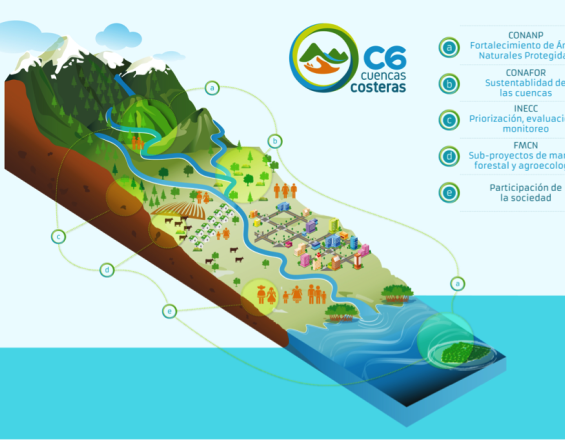
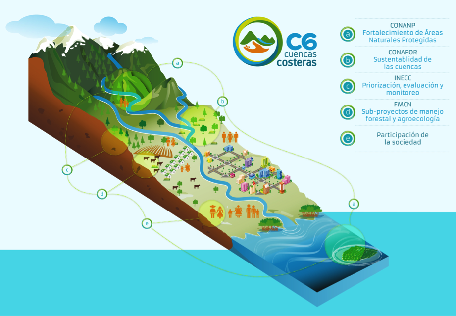
At the centre of PAMIC is water - water is the conductive element that brings together the different actors. Building Block II "Creating a shared vision of land management through water" makes these connections by matching demand for hydrological services from land use managers with supply of such services from the river basin. This building block in turn provides the incentive for Building Block III "Key elements for the conservation of ecosystems are also anthropic". It aims to create an understanding among stakeholders that sustainable ecosystems need sustainable communities that live off of them, and thus will take care of them. Supporting both these blocks from the ground up is Building Block IV "Support from local institutions and grassroot organizations", which coordinates the vital support of local Non-Governmental Organizations (NGOs) and Civil Society Organizations (CSOs) in the long-term mentoring of local communities. Finally, top down support is provided by Building Block I "Inter-institutional governance at different levels", which provides the institutional support framework in which the whole solution can function.
Building Blocks
Inter-institutional governance at different levels
To create and develop PAMIC, diverse government entities belonging to the environment sector joined forces to design a cutting edge and innovative project: the National Institute of Ecology and Climate Change (INECC) coordinated the construction of the PAMIC plans; The National Comission of Natural Protected Areas (CONANP) consolidated the management and operation of the project within the Protected Natural Areas (ANP); and the National Forestry Comission (CONAFOR) implemented Payments for Environmental Services schemes from the biodiversity fund. The Mexican Nature Conservation Fund (FMSN) contributed its experience in the management of financing schemes. All in all, this created two further funds to stimulate activities and impacts. Moreover, the inter-institutional coordination included i) a Technical Project Committee that supervised and directed the operation of C6; ii) a Unit Project Coordinator and iii) two Regional Project Units, which were responsible for the daily coordination of technical and logistical issues. Such a design has been an essential aspect that generated major advances in land use planning for collective benefits.
Enabling factors
- Very good coordination between the institutions, all of which share a clear vision of the use of different financial and management instruments;
- Sufficient financial and institutional resources;
- Experience and interest of the institutions involved;
- Experience in the implementation of existing programs, e.g. social assistance programs, subsidies, Payments for Environmental Services, etc.
Lesson learned
- Coordination efforts benefit from forms of polycentric governance between levels and stakeholders. This scheme of governance is backed by formal agreements between institutions that establish the rules of the game for all the other organizations and stakeholders involved in the project in a transparent manner.
- Formal institutional agreements can produce a planning instrument which is dynamic and can strengthen decision-making, helping each stakeholder to make the most of different planning elements for land use management.
- There has been a visible increase in confidence on the part of key institutions in local scale land use planning processes. This can be seen in improved decision making and use of programme funds.
Creating a shared vision of land management through water
In order to promote an operational connectivity between the diverse upriver and downriver sub-basins (zones) of a river basin, including both ecosystems and productive activities, water was chosen as the conductive element; the element to bring the zones and stakeholders together. Modelling of the surface water supply and sediment retention in different zones permitted the identification of provider-recipient-accumulation relationships. Through this, the dynamics between demand for hydrological services (e.g. populations, tourist zones) and those that produce them (mountainous zones with forest cover) could be identified and connected. Based hereon, the different stakeholders were brought together to learn about and exchange on key information on zonal levels of production and services available. This in turn led to the identification of what should be done where and by whom.
Enabling factors
- A network of NGOs with sufficient experience to mentor producers and other stakeholders;
- Availability of quality teaching materials and methods usable by and with communities;
- Commitment and interest from different stakeholders and government insitutions towards the whole project
Lesson learned
The intrinsic connectivity of the PAMIC methodology has proven to be the aspect that attracts interest from the government entities and from land use stakeholders. The tool helps to identify who they can work with regarding productive activities (i.e. coffee, sugar production). This aspect has enabled local actors as a group to understand the dynamics between micro watershed units.
Key elements for ecosystem conservation are also anthropic
As part of PAMIC, great consideration on the dynamics of landscape transformation is being made. There is an attempt to identify and conserve those elements that are key for ecosystem conservation, whether they are of natural or anthropic origin. In PAMIC´s philosophy, conservation does not mean maintaining pristine ecosystems. On the contrary, conservation includes restoring managed landscapes and using sustainable practices. This allows the maintenance of the whole socio-ecological system through a sustainable use of the land, as demonstrated by shade-grown coffee production, agro-silvo-pastoral and community forest management projects, which support both livelihoods and ecosystems.
Enabling factors
- Confidence in the social and environmental benefits of sustainable community management
- Institutional learning about the long term limitations of the "do not touch" vision of conservation as a means of conserving ecosystems;
- Network of actors with knowledge on land use and water management
- Long term mentoring of the producers;
- It is vital to make use of existing local cooperatives to generate, lead and manage the introduction of new approaches to existing productive activities
Lesson learned
- When communities feel that their productive activities are not being threatened, they are more willing to get involved and undertake self-organized initiatives for the sustainable management of ecosystems.
- Likewise, when they identify the project as a window of opportunity to obtain support and possible financing to improve their productive activities, the commitment and interest to sustainably manage the ecosystem increases.
Support from local institutions and grassroots organizations
The Project Unit Coordinator has been forming an alliance with local governments, research centers and grassroots organizations with specific presence in each of the project basins. This way, effective communication with producers and other actors in the territory could be ensured. Thanks to the network of local NGOs, information and results workshops had high levels of impact and thereby allowed for a more efficient translation of stakeholder insights into practicable solutions in the field. Examples of this support on the ground include: i) the management of different interests and potential conflicts between actors in the Cofre de Perote NPP; ii) the connection of governmental social assistance programs, subsidies, etc., to river basin zones that coincide with the project, which in turn created useful synergies; iii) the establishment of coordinated lines of work from the government level to protected natural areas (ANP) and to CSOs; iv) the coalition among CSOs has had impact on the river basin and in reducing costs, by making complementary use of the different capacities of the actors involved.
Enabling factors
- A network of NGOs experienced enough to offer practical training to producers;
- Existing levels of organization of communities, producers, and local authorities on which to build initiatives, e.g. ejido assemblies, fishing cooperatives, rural production units, etc.;
- A shared sense of identity and belonging among producers, communities and local authorities.
Lesson learned
- It has been vital to have a network of civil society organizations that collaborate in the project and help to promote good practices in the river basin.
- Each basin is different, therefore having local CSOs and NGOs as partners of the project has allowed better tailoring of project activities according to the characteristics of each community or zone.
- It is essential, however, to have a good management and coordination of the CSO/NGO network to ensure that all involved stakeholders are aware of each others' activities.
Impacts
- The inter-institutional coordination between the key environment sector government entities and national and international NGOs, as well as community groups, has strengthened the pathways of inter-institutional cooperation. It has created an important precedent for the sustainable management of resources.
- With PAMIC, the river-basin scale land use and water management planning benefits from a vision of the connectivity between key zones of water supply and sediment retention, and key zones of demand for these services.
- The conservation of ecosystems alongside the promotion of sustainable production has been key to sustainable community adaptation within the river basin.
- Permanent funding has been assured for a large number of Protected Natural Areas (ANP, using the Spanish acronym).
- A coalition of local NGOs has been achieved, creating synergies which have led to resource savings.
Beneficiaries
- Authorities have a planning instrument that promotes sustainable management and the organization of producers within river basins;
- Local communities have received technical, financial and organizational support for improving productive practices.
Sustainable Development Goals
SDG 6 – Clean water and sanitation
SDG 13 – Climate action
SDG 15 – Life on land
SDG 17 – Partnerships for the goals
Story
Starting with an inter-institutional alliance between government entities in the environment sector (Instituto Nacional de Ecología y Cambio Climático, INECC; Comisión Nacional Forestal, CONAFOR; Comisión Nacional de Áreas Naturales Protegidas, CONANP), national and international funding organizations (GEF, Fondo Mexicano de Conservación de la Naturaleza), and a large network of twenty three local organizations and producers, the C6 project has brought to Mexican land use planning a new level of integration and operational management, in the form of “Integrated River Basin Management Action Plans” (PAMIC, using the Spanish acronym). Such plans seek to promote the connectivity between land and people by focusing on actions that permit the maintenance and conservation of key landscape elements that provide hydrological services. In this way, they can stimulate climate change adaptation processes. To achieve this goal, the plans were discussed within the project, whereby water was used as a conductive element to unite the different stakeholders in the river basin. As a result, it was possible to establish criteria and solid scientific foundations for modelling the land-use dynamics. Based on this, PAMIC has the following characteristics: i) a relational focus to identify the dynamics and externalities between sub-basin units; ii) an explicitly spatial approach to identifying what to do and where.; and iii) the identification of the relationship between supply of and demand for hydrological services between sub-basin units (zones).
The modelling of hydrological services (i.e. surface water supply and sediment retention) permitted the identification of zones in each basin that are important for the two types of services. Subsequently, these zones were coupled with information and perceptions from the basin stakeholders on the levels of production in the zones, their institutional norms, and socio-economic processes. This generated a shared vision of the basin and from here, a collective reflection on what should be done, how and by whom. These questions were the beginning of a process to create proposals for priority activities to maintain hydrological services, forests and production zones.
An innovative element has been the search for funding mechanisms that can assure a permanent economic resourcing of projects in the medium to long term. Currently, there are eight river basins that have a PAMIC, and five more that are in the process of developing one.
Connect with contributors

Other contributors
José Machorro
Instituto Nacional de Ecología y Cambio Climático
Leonel Zavaleta
Fondo del Golfo