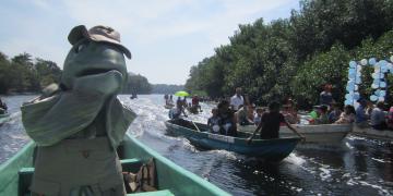
Community-based identification and validation of the restoration site
Preparatory meeting, mobilization of the community and implementation
Observation and monitoring of restored mangrove sites
Evaluation of the first results by the local community
Community engagement
We involve all stakeholders in all decision-making and invite all community members wo might be affected by projects to community meetings to ensure that there is no misunderstandings. It should be noted that we explicitly expect communities to contribute to the success of projects - be it through digging a well themselves, providing bricks when preschools are built, or taking care of planted trees.
WfZ is known to be able not only to implement projects but as as well to support them after the initial successful implementation. This means, we do not only install the Zoë-pumps but we also maintain and service them. The same goes for preschools and education projects. We support projects on the long run and the communities are aware of it. Community members value this ongoing support highly and are keen to participate in learning opportunities.
From our experience we highly recommend to be mindful to have some reserves left to maintain projects over a long period of time and to assume that it takes the community some time to get accustomed to manage projects themselves effiiciently. Only then can charitable work coming from outside into a community become successful and truly sustainable
As women in rural malawian families are usually responsible to cook for their family members, they are also the ones who predominantly collect firewood, as well as to pump and carry water.
Women are therefore the ones whose training will have the biggest impact on how they perform these practices for example: If a tree is cut off at about 1m height above ground it will coppice, if however the roots are dug out to get more firewood, then a close to irreversible damage will incur, so training is very important.
By training and hiring mostly women for all steps required to restore a landscape we give them the basic tools and education to bring sustainable change to their landscape - as well as changing the basic income structures as their work often becomes the main source of income for the family.
At Wells for Zoë we have women in leadership positions managing several project implementations from the Secondary Girl Student Project, and the Preschool Project where caretakers are being educated. They also visit reforestation and restoration projects and influence our hiring policy of local workers involved in the projects.
Generally speaking, being able to hire local women and pay them is a majorly important factor to enable female empowerment.
Female employees and workers are grateful and report that the payment and education they receive, changes their lives to the better as they can pay schoolfees for their children and provide a richer diet for themselves and their family or start small scale businesses with the income earned.
Technology knows no barriers and we are yet to innovate and discover more with a changing world.
By using the underwater cameras it has allowed us to bring ahead the live viewing and monitoring where previosuly we were limited. Thus allowing us to better engage with local fisher community, for them to get a sense of ownership and unite to better understand and protect this ecosystem.
This has also facilitated the data sharing of the status of the reef locally and across different channels but also to open the door for more scientific collaboration locally and internationally.
Local community buy-in
Interactive technology
Data sharing
Technology here not only brought live viewing and interaction but a completely new level of underwater restoration. Fish and coral interaction can be securely monitored allowing scientist to discover more about underwater interactions.
Inspired by our transparent way of GPS-mapping our more than 2000 installed Zoë-pumps we knew we had to apply the same principle and expand it to show and document our tree planting projects.
Now we have an elegant solution: We create GPS-Polygons of planting sites by walking around it with a simple smart phone app. We then import these boundary files into the drone mission planning app and fly a drone over the planting site capturing thousands of images.
These are then stitched into a large photogrammetric map that can transparently show and document landscape change through the work happening on the ground. Additionally all workers inspecting the sites take thousands of GPS-photos which are displayed on our custom built map as well.
We are lucky enough to have a malawian team that is highly skilled and trained well enough so that we can 100% rely on their work and the results they deliver.
Apart of that it is important to have reasonable drone laws in a country, as well as having access to a drone and a pilot.
In the very beginning of the drone monitoring we had to research the best workflow to map an area with no network terrain-aware. As this took a lot of time and turned out to be actually not even that complicated we wanted to share our knowledge and created a learning series on drone monitoring in cooperation with One Tree Planted and it is now freely available on youtube and covers all there is to know: