Skip to main content
Main navigation
Explore solutions
Network
Resources
News & Events
Contribute solution
Secondary navigation
About PANORAMA
Partners and Collaborators
Communities
Utilities navigation
Newsletter
Manual
FAQ
English
English
Français
Español
Deutsch
Italiano
中文
العربية
Bahasa Indonesia
한국어
Русский
Português
日本語
Nederlands
Türkçe
User account menu
Log in
Register
East and South Africa
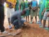
Youth-centric restoration in Thyolo
Dickson Demister
Mthonyiwa
2 Building blocks
Self-help
Youth engagement
North Africa
West Asia, Middle East
East Asia
Utilize Treated Aeolian Sands to Combat Food Insecurity in Desert Regions
Yuming
Su
4 Building blocks
Environmental Education: UAE Dwight School Tree Planting
Arid and Semi-arid Landscaping: Home Gardening
Community Outreach and Stewardship: JA Hotel Tree Planting
Desert Farming: "Breathable Sand" Farm in Ras Al Khaimah
North Europe
The Winmarleigh carbon farm
Jenny
Bennion
West and South Europe
Shelters for archaeological sites: protecting heritage and enhancing visitors’ experience
Ruben
Abela
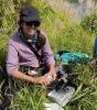
Oceania
Restoration of Kamaka Island, a sanctuary for Gambier biodiversity
Tehani
Withers
3 Building blocks
Development of a compelling Operational & Biosecurity Plan
Use of cutting-edge technology for project implementation
Raise awareness of the local community on indigenous species, threats and biosecurity measures
East and South Africa
Using IMET to identify Priority Actions for Improved Management Effectiveness of the Mafinga Hills Forest Reserve in Zambia
Gift
Mwandila
3 Building blocks
Stakeholder Identification
Capacity development
Effective communication
West and Central Africa
Using the IMET tool to identify management priorities for the Ngog-Mapubi Dibang inter-communal forest
Roger
Ngoufo
4 Building blocks
Raising stakeholder awareness
Choice of an experienced coach to train and lead the exercise
Adoption of an alternative system for holding meetings and activities between the two communes
Dialogue and identification of priorities
East Asia
Endangered Species Conservation and Patrol Project Launched in Xingfu Wetland
Li-Chuan
Weng
West and South Europe
T4N: Create CO2 certificates using biodiversity measures
Roman
Eyholzer
4 Building blocks
Additionality
Avoid double counting
Long-term sequestration
Baseline
West and Central Africa
The IYEMBE MOKE village terroir and its contribution to biodiversity conservation
Héritier
MILENGE KAMALEBO
2 Building blocks
Territory developed and managed by customary authorities
Existence of a local development committee (CLD)
Pagination
Previous page
‹‹
Page 152
Next page
››
Subscribe to Local


 piloting the drone on Kamaka Island")


")