Connected Conservation Foundation
Full Solution
The comprehensive LoRaWAN network
Connected Conservation Foundation
Protected areas are vital for biodiversity, livelihoods, and climate stability—yet 60% of African parks remain “paper parks” due to limited infrastructure.
Connected Conservation Foundation (CCF) is bridging this gap with Internet of Things (IoT) tools that deliver real-time data to monitor ecosystem health, detect threats early and empower communities.
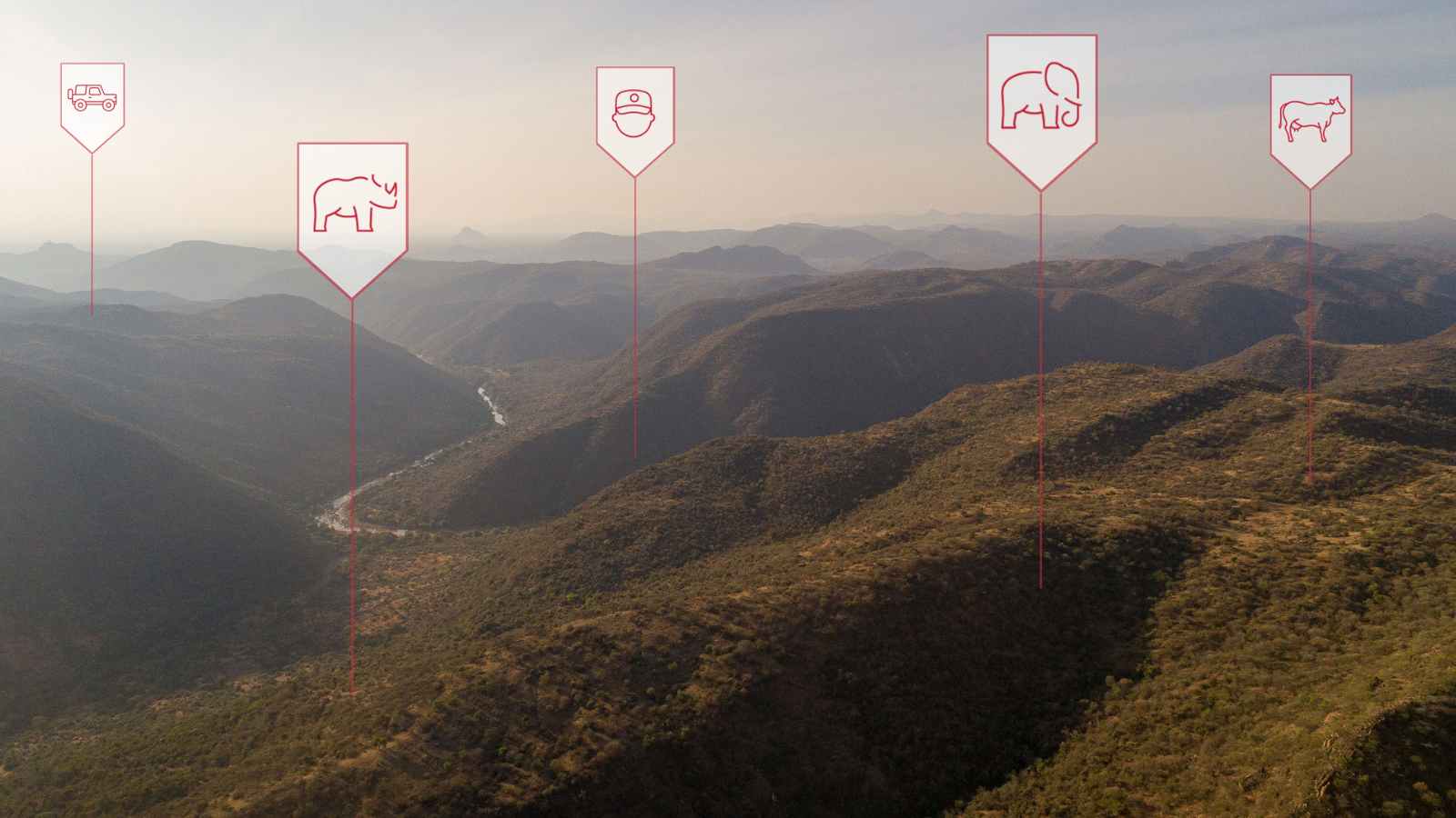
Since its 2019 pilot at Kenya’s Lewa Wildlife Conservancy, CCF has developed a large-scale sensor ecosystem with Actility, Cisco and EarthRanger. Long Range Wide Area Network (LoRaWAN) networks now cover 10M hectares across Kenya, South Africa and Uganda—including the Masai Mara, Tsavo and Northern Rangelands. Over 1,000 sensors and 131 gateways in 35 conservancies feed into EarthRanger, providing a comprehensive 360-degree view of ecosystem health and threats, supporting teams to track assets, onboard sensors, and respond to dangers. This scalable tech stack drives biodiversity conservation action, protects livelihoods and supports the global 30x30 conservation goal.
Last update: 31 Oct 2025
309 Views

Context
Challenges addressed
- Inefficient protected area management: Many parks lacked the necessary digital and physical infrastructure for effective data-driven management, with 60% of vital protected areas in Africa identified as "paper parks" requiring better infrastructure and management solutions.
- Bush meat and rhino poaching crisis: South African reserves faced relentless poaching, with incidents increasing in 2021, culminating in significant losses of this critically endangered species.
- Climate and resource Conflicts: Areas like the Northern Rangeland Trust faced significant climate impacts, such as prolonged droughts, flooding and conflicts over natural resources.
- Ranger safety: Rangers working to protect biodiversity and ecosystems lacked adequate communication devices, with only 43.2% having consistent access to keep them safe. This hindered their ability to respond effectively to threats and stay safe in other off-grid emergencies, such as predator encounters.
- Escalating human-wildlife conflict
Location
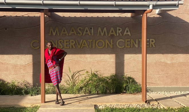
Kenya
South Africa
Uganda
East and South Africa
Process
Summary of the process
The development of the LoRaWAN-based conservation technology network has evolved over several key phases.
In the early stages, Cisco played a pivotal role by donating LoRa gateways, an on-premises server and LoRa Network Server (LNS) software to Northern Rangelands Trust and Lewa Wildlife Conservancy. While Cisco has since retired its LoRaWAN gateway product line, gateways are now acquired through donations or purchases from providers such as Tektelic, RAK and Milesight.
As the initiative grew, Actility joined the partnership, further strengthening the network by providing its ThingPark™ Exchange platform and Software as a Service (SaaS) LoRa Network Servers. These tools, along with other services from Actility’s product portfolio, are donated to selected NGO partners to help scale conservation efforts.
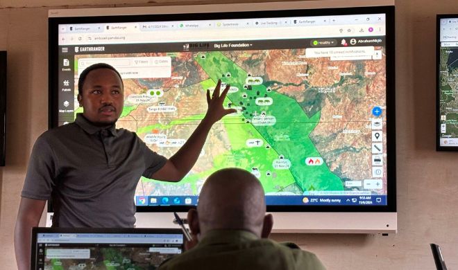
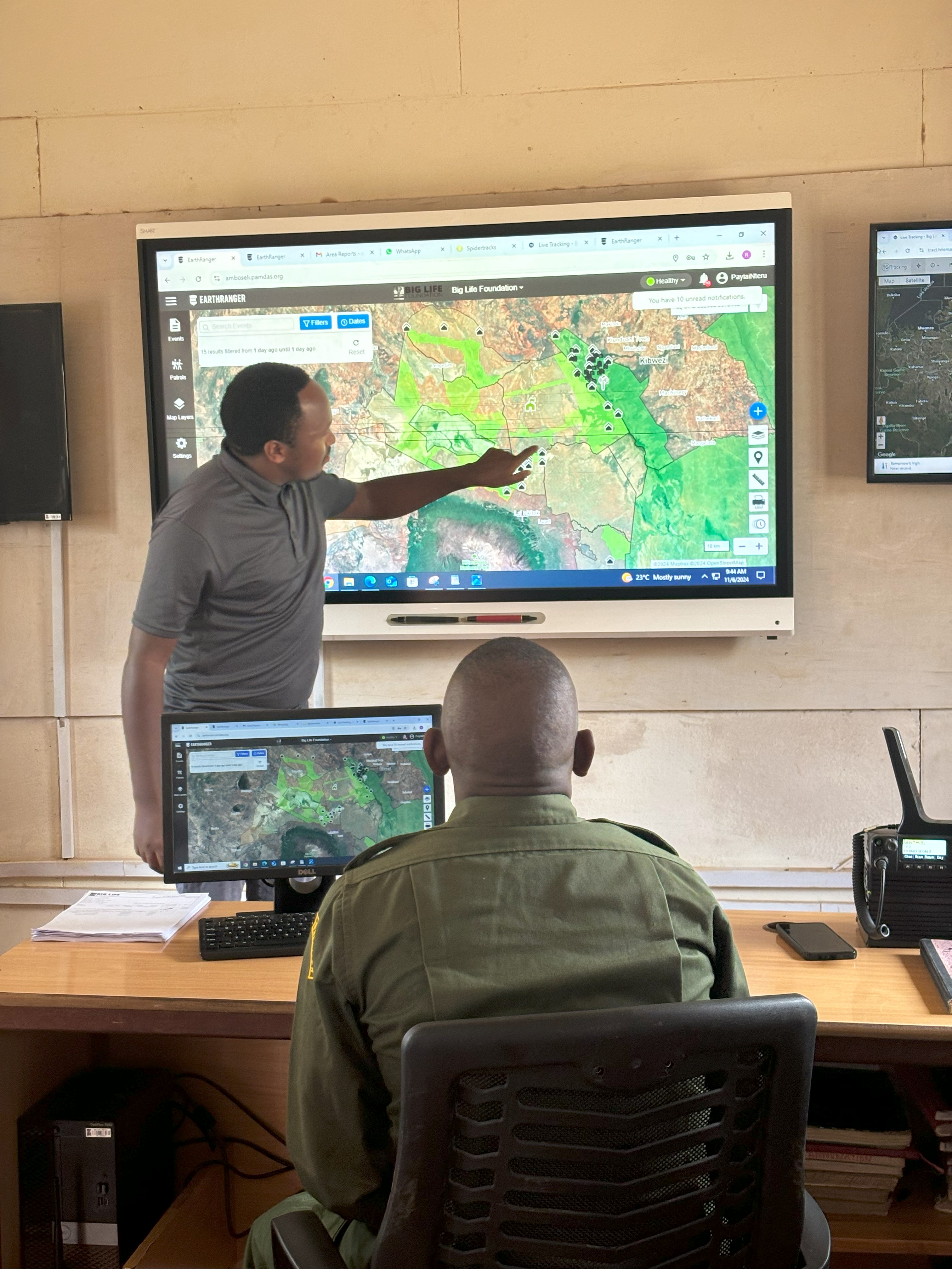
The first version of the “Connected Conservation” IoT integration platform was launched in 2019. It used a small number of custom-built flows on Node-RED, an open-source JavaScript-based tool, to decode LoRaWAN messages from the network server. These decoded messages, enriched with relevant context, were then forwarded to EarthRanger—the first platform to receive and visualise the data.
Building Blocks
Filtering data types and onward rooting
Actility LoRaWAN Things Park Network ServerThe network server connects sensors, gateways and end-user applications and ensures reliable and secure data routing all along the LoRaWAN network. Along with the Operation Support System (or OSS), they are the brain that controls the complete LoRaWAN network
Enabling factors
- Collects data from the LoRaWan Gateways and transports this data from field-based sensors onto Node Red, which sends data to Earth Ranger (a data visualisation software).
- It can be self-managed through training.
- It is easy to replicable.
- It can be deployed on-premise or on the cloud
Lesson learned
Today, Actility’s IoT network server supports 131 LoRaWAN gateways with CCF and nearly a thousand sensors across 35 community-led and private conservancies. These networks span iconic landscapes like the Masai Mara, Tsavo and Northern Rangelands of Kenya, forming a digital safety net across nearly 10 million hectares.
Government agencies, including the Kenya Wildlife Service and Uganda Wildlife Authority, have endorsed the LoRaWan approach for expansion across national parks and community lands.
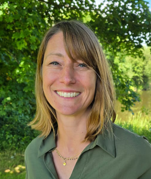
Transporting data from the field to the operations room
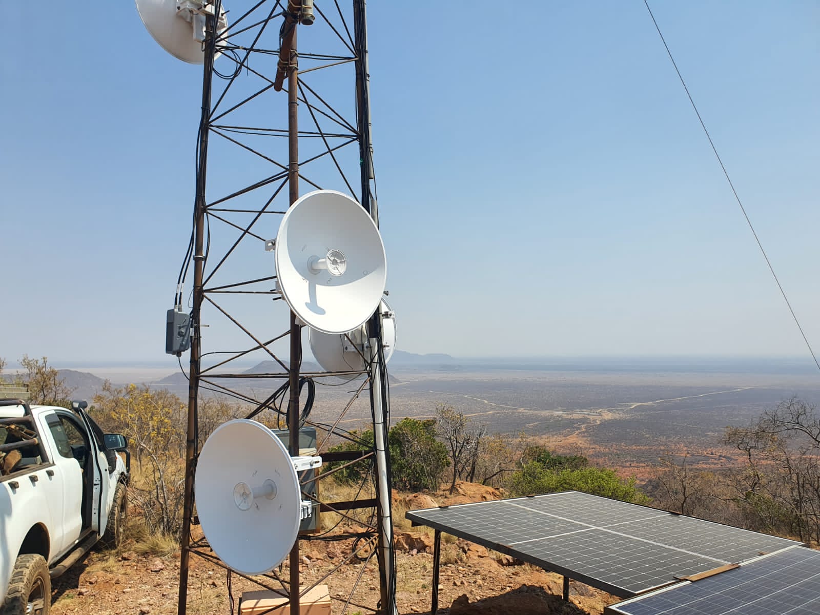
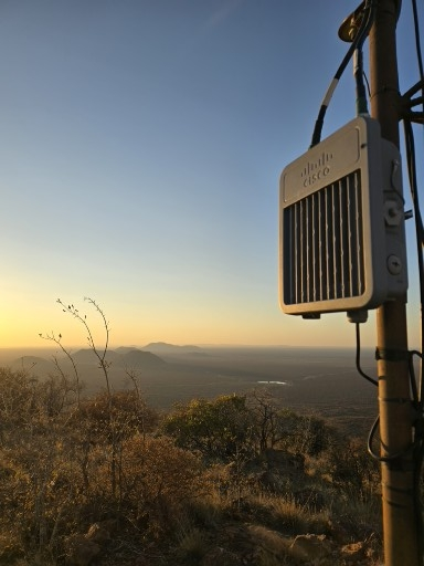
From soil moisture and water levels to animal migrations and habitat health, data from sensors travels via Cisco LoRaWAN gateways and Actility’s ThingPark™ Platform to central operations rooms, where platforms like EarthRanger provide a comprehensive 360-degree view of ecosystem health and threats. Previously, these have been donated by Cisco Inc.
These LoRaWan gateways now support over 800 IoT sensors across protected areas.
Enabling factors
- When using LoRaWAN, data is transmitted wirelessly to a gateway. The gateway listens for the corresponding signals and transmits them to a LoRaWAN network server, which is connected to the Internet.
- Deploying a LoRaWAN network is quicker and much more accessible than setting up a conventional cellular system.
- Operation requires minimal infrastructure. Setting up cables and making connections to the power line is not required. Network design and optimisation are also simplified, as with one gateway, you can cover a larger area very effectively.
Lesson learned
- Reliable and long-term : The gateways are robust and come with a 7-year warranty, offering peace of mind and operational security for protected area managers working in harsh and remote conditions.
- Unmatched coverage in rugged terrain: LoRaWAN technology continues to outperform alternatives in remote and rugged landscapes, providing extensive and reliable coverage across challenging terrain where cellular connectivity is limited or non-existent.
- Seamless regional asset tracking: The system supports device roaming, allowing for uninterrupted tracking of assets across different regions without manual reconfiguration—an essential feature for mobile wildlife monitoring and conservation equipment.
- Cost-effective: By leveraging low-cost, commodity-based hardware and integrating standard radio modules, LoRaWAN devices reduce overall deployment costs significantly. Compared to cellular or Wi-Fi-based solutions, this makes wide-area sensor networks more financially accessible for conservation teams.
- A scalable and sustainable alternative: With its low power consumption, long range and minimal infrastructure needs, LoRaWAN provides a sustainable alternative to satellite communication. It enables real-time environmental monitoring in even the most isolated locations.
- Widespread adoption for Conservation: Outside of this partnership, over 200 protected areas across the country are now using LoRaWAN to monitor vital resources like water, food, and habitat health. This growing adoption is helping secure a resilient future for wildlife, ecosystems, and the communities that depend on them.
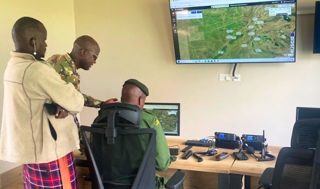
Centralising data for management and control
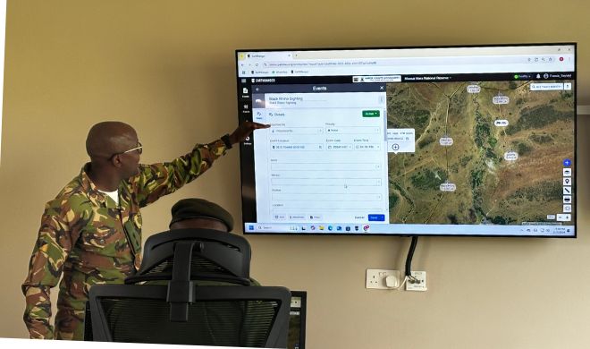
A visualisation platform for real-time protected area management, helping managers make informed, conservation-related operational decisions. A community of users is now sharing best practices and innovative concepts, engaging EarthRanger as it extends beyond just elephant protection to a diversity of wildlife, ecological and community applications.
Enabling factors
CCF has a long-term partnership with the AI2 Team, which developed this software.
Lesson learned
- Data flows seamlessly from field-based hardware through the network into Earth Ranger
- Diagnostic information is key to good support and maintenance.
Technical support and training
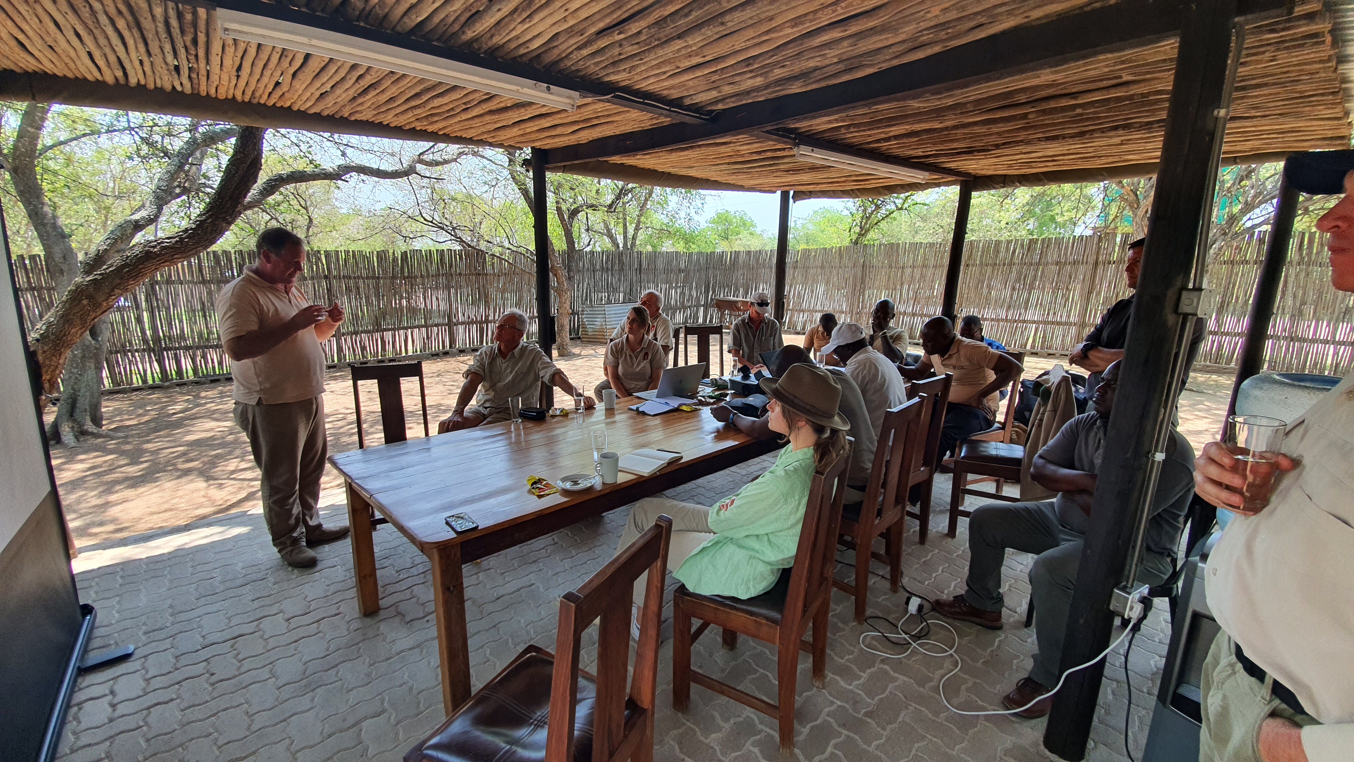
CCF provides a holistic digital ecosystem integrating landscape-scale technology, training and community engagement to drive meaningful change, contributing to GBF Target 20 – Strengthen Capacity-Building, Technology Transfer, and Scientific and Technical Cooperation for Biodiversity.
Enabling factors
Launching in June 2025, the Protected Area Technician (PAT) Training Programme has been developed by CCF to empower local communities to protect nature.
This tailored programme is designed to build practical, in-demand skills that create real opportunities—from entry-level technician roles to long-term careers in leadership and consulting within protected areas. Co-developed with industry experts and rooted in local needs, the curriculum blends hands-on field training with applied conservation technology knowledge.
Participants will graduate with job-ready skills to support and maintain vital conservation tech infrastructure. They’ll also have the opportunity to earn a PAT Certification, with a pathway to a globally recognised Cisco Certification—unlocking even broader career potential in the conservation and tech sectors.
By investing in local talent, the PAT programme helps communities take a leading role in protecting the natural landscapes they call home.
Lesson learned
Monitoring of impact will take place through the first cohort of learners, focusing on their career journeys and personal development outcomes
Community engagement
Communities must benefit from the data collected, and we ensure they do.
We support quarterly data-sharing meetings between Northern Rangelands Trust (NRT) community conservancies and Big Life Foundation, creating an open forum where data informs collaborative decision-making. This includes town planning, land-use strategies and community-led conservation initiatives.
By sharing insights on wildlife movements, environmental conditions and human activity, communities can plan together for peace, security and the prevention of human-wildlife conflict (HWC). These sessions empower conservancies to co-develop solutions across landscapes, strengthening cross-border cooperation and ensuring that data drives action where it’s needed most.
Enabling factors
Control over data sharing or privacy.
Lesson learned
Community stewards are empowered and trained to collect data through different sensors, using the IoT network to feed data into control rooms and Earth Ranger.
Impacts
Case study: Northern Rangelands Trust
Improving peace and security
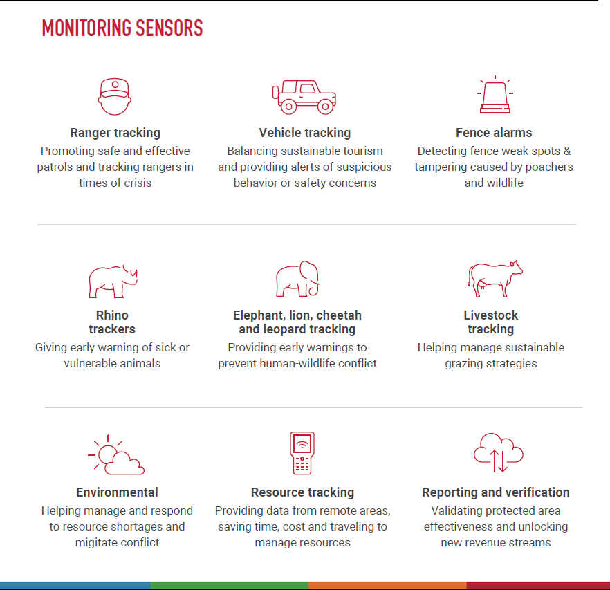
Data from ranger, vehicle and wildlife sensors are helping rangers monitor and respond to rhino threats to prevent poaching, share information on vulnerabilities, bolster conservation management strategies and redeploy security measures between conservancies.
Rhino recovery
Kenya is one of the few places in the world where black rhino populations are increasing. But with this success comes an urgency to establish safe and connected rangelands for these critically endangered species to roam. This project has enabled innovative ways to monitor the rhino population and has helped bring the removal of fences between conservancies, creating larger, connected habitats for rhinos.
Managing and verifying natural resources
2022 saw extreme drought in East Africa, sweeping away grasslands, water, local food and animals. NRT faces huge challenges in managing its natural resources sustainably and pre-empting and reducing human and wildlife conflict. The IoT network supports the plugin of livestock and environmental sensors to monitor foraging conditions, track livestock movements and observe water levels that threaten the successful co-existence of wildlife and local people.
“This IoT solution is a game-changer for conservation efforts in Northern Kenya. We can now monitor our conservancies on a scale that was never possible,” says NRT’s CEO, Tom
Beneficiaries
Kenya: Northern Rangelands Trust (22 parks including Sera), Ol Jogi, Loisaba, Lewa Wildlife Conservancy, Borana, Tsavo, Amboseli, Masaai Mara
South Africa: Sabi Sand, Lapalala, Madikwe, Mkuse Valley
Uganda: Kidepo, Murchison Falls, Queen Elizabeth
Additionally, explain the scalability potential of your Solution. Can it be replicated or expanded to other regions or ecosystem?
Our solution is highly scalable and has already demonstrated its ability to be replicated across diverse regions and ecosystems, directly contributing to the following global biodiversity and sustainable development goals:
Launched in 2019 with a pilot at Kenya’s Lewa Wildlife Conservancy, the initiative has since scaled across Kenya, South Africa, and Uganda. Actility’s IoT network server now supports 131 LoRaWAN gateways and nearly 1,000 sensors across 35 community-led and private conservancies, spanning close to 10 million hectares. These digital networks protect over 35 threatened species—including rhinos, elephants, and pangolins—while enabling data-driven habitat and security management.
The technology enables real-time monitoring of biodiversity, land use, water availability and human-wildlife interactions, supporting GBF Target 1 by helping communities and protected area managers plan and manage land more effectively to reduce biodiversity loss. In areas suffering from environmental degradation, sensor data informs targeted restoration efforts, directly supporting GBF Target 2. The scalability and affordability of LoRaWAN networks mean this model can expand rapidly, helping to conserve more land and ecosystems, aligning with GBF Target 3.
In Uganda, for example, new deployments in Kidepo Valley, Murchison Falls, and Queen Elizabeth National Parks are now reinforcing anti-poaching efforts, aiding snare detection, and supporting communities to manage natural resources more sustainably.
This work also advances SDG 15 – Life on Land, by promoting the sustainable use of ecosystems, halting biodiversity loss and enhancing local capacity to manage and restore degraded habitats.
Over 200 protected areas now use this technology to monitor critical indicators such as water levels, soil moisture, and wildlife movement, building long-term resilience for both people and the planet.
By weaving together conservation partners, communities and governments under a shared digital framework, this initiative demonstrates the power of public-private collaboration, championing SDG 17 – Partnerships for the goals. It’s a scalable, data-driven model that’s helping to secure the interconnected health of wildlife, ecosystems and the communities that protect them.
Global Biodiversity Framework (GBF)
GBF Target 1 – Plan and Manage all Areas To Reduce Biodiversity Loss
GBF Target 2 – Restore 30% of all Degraded Ecosystems
GBF Target 3 – Conserve 30% of Land, Waters and Seas
GBF Target 4 – Halt Species Extinction, Protect Genetic Diversity, and Manage Human-Wildlife Conflicts
GBF Target 8 – Minimize the Impacts of Climate Change on Biodiversity and Build Resilience
GBF Target 11 – Restore, Maintain and Enhance Nature’s Contributions to People
GBF Target 20 – Strengthen Capacity-Building, Technology Transfer, and Scientific and Technical Cooperation for Biodiversity
Sustainable Development Goals
SDG 4 – Quality education
SDG 13 – Climate action
SDG 16 – Peace, justice and strong institutions
SDG 17 – Partnerships for the goals
Story

Field partners implementing LoRa-enabled rhino tracking tags
© David Chancellor
Once on the brink, now on the move: The return of Kenya’s Black Rhinos
- 230km Rhino Sanctuary - Lora Network Created
- 21 - Newly introduced Rhino
Nearly wiped out by poaching in the 1970s and ’80s, Kenya’s black rhinos were driven to the edge of extinction. But today, a powerful comeback is underway, with Loisaba Conservancy leading the charge.
With an ambitious goal to restore the national black rhino population to 2,000 by 2037, Kenya is thinking big. The key? Space. Rhinos need room to roam expansive, open landscapes free from fences, where they can graze, breed and live wild. Across the country, conservancies are breaking down barriers, removing fences and stitching together fragmented rangelands into safe, connected corridors.
In 2024, a landmark moment arrived. For the first time in decades, rhinos set foot on the 230 km² Loisaba Conservancy in northern Kenya. Their return doesn’t just mark the revival of an iconic species, it completes Loisaba’s ‘Big Five’ and ignites a new wave of eco-tourism, job creation and investment in local communities.
Ensuring they thrive requires cutting-edge support. Partnering with Cisco, Actility and Loisaba’s skilled ranger team, CCF facilitated the build of a digital safety net for these animals. With advanced LoRa gateways, a resilient cloud-based network and real-time IoT integration, every rhino’s movement is now tracked through EarthRanger. This is giving rangers a window into the health, habits and safety of each rhino, helping them respond faster and protect more effectively.