Intersectoral Collaboration and Conservation Technology Pipelines to Combat Biodiversity Loss in Protected and Conserved Areas of Vietnam
Full Solution


Successful poaching mitigation in the core zone of Pu Mat National Park
CC-BY-NC
By installing an NGO-based anti-poaching team, and using various anti-poaching technologies in Pu Mat National Park, we were able to effectively maintain spatially explicit records of poaching activities, profiles of offenders, strategically implement automated poaching alert systems, and significantly decreased the number of poachers, traps, and camps within the core zone of the protected area while also substantially mitigating poaching activities throughout the entirety of the park. In doing so, we managed to identify and apply pressure on high-risk poaching areas, create avoidance of poaching in locations where high-priority (Endangered, and Critically Endangered) species were present, maintain a working database of offences and offenders within the protected area to understand more about the social aspects of poaching, and built capacity for all operating rangers in the protected area to use the same methods and technologies themselves.
Last update: 09 Aug 2022
1876 Views
Photo and video gallery
Context
Challenges addressed
- Poaching of wild flora and fauna in protected areas is widespread throughout Vietnam
- Law enforcement in protected areas of Vietnam is generally ineffective due to low pay and poor welfare of rangers and lack of necessary tools/resources.
- Forest rangers are primarily trained to focus on preventing deforestation through illegal logging; however, biodiversity loss has not been a primary area of focus until recent years because biodiversity loss is more difficult to measure than forest loss and is much more resource intensive.
- National Park managers and rangers in Vietnam typically do not use management effectiveness tools, standardized data collection methods, or databases of illegal activity within protected areas
- Due to the rarity of endangered species and the disturbance caused by active patrols and surveys, it is difficult to designate high-priority locations to apply patrolling pressure to protect threatened species due to low detection rates.
Location
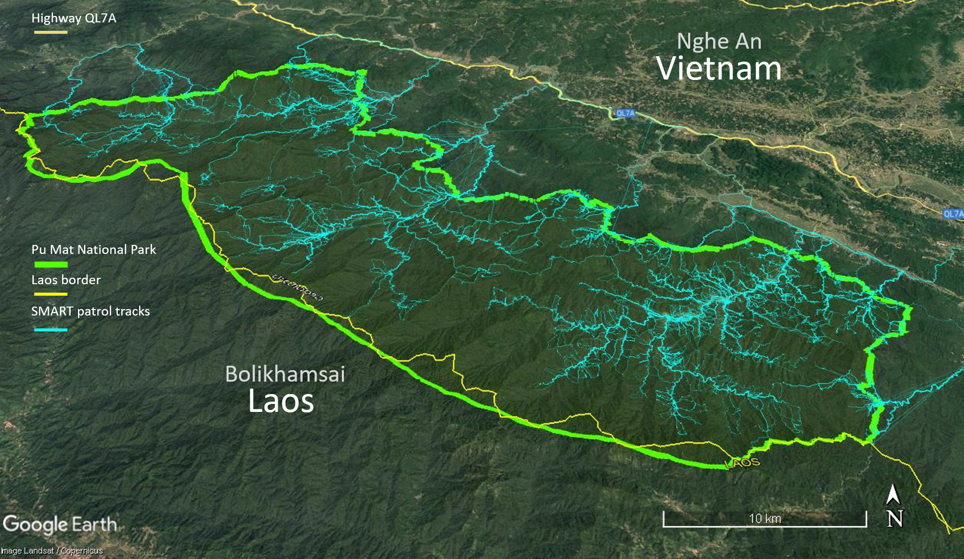
Châu Khê, Huyện Con Cuông, Nghệ An, Vietnam
Southeast Asia
Process
Summary of the process
Each of the above elements interact with each other via human resources, intelligence, and strategic application to ensure overall site protection efficiency and success. Our anti-poaching team interacts with government rangers to build capacity by transferring knowledge over time and habituate them to using the SMART mobile data collection tool in the field. SMART is used to analyze and plan following patrols based on past patrol data collected from each unit. PoacherCams are set based on entry locations discovered by patrols and high-traffic poaching data, and are installed at entry points as an early warning system for rapid-response mobile ranger units. Camera traps provide insights into high-priority patrol locations to reduce hunting activities where rare and threatened species occur.
Building Blocks
Anti-poaching team
Anti-poaching (AP) teams are hired and funded under Save Vietnam's Wildlife, and approved by protected area managers where they sign a joint contract between the two. They undergo approximately one month of training in Vietnamese forestry law, species identification, self-defense, field training, first aid, and using SMART.
AP patrols stay with forest rangers for 15-20 days of patrolling at various ranger stations each month, and an assigned Data Manager typically processes, cleans, analyzes and reports SMART data for all patrols to the park director and SVW coordinators. At the beginning of each month, a SMART report is generated by the data manager; based on the intelligence from this report, a patrol plan will be discussed with the ranger and anti-poaching members, and then submitted to the protected area director for approval; mobile units are on standby and led by forest rangers to rapidly respond to any emergencies, locations outside of planned patrol areas, or situations accessible by road.
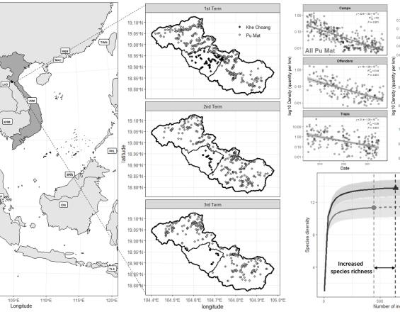
Rangers were trained to use SMART mobile through vertical knowledge transfer in the field, and by the end of 2020, 100% of the forest rangers (73 people) were all effectively using SMART, increasing patrol data coverage across the entire protected area (Figure 1).
Enabling factors
- Collaboration between NGO-based law enforcement assistants (the SVW anti-poaching team) and protected area managers and forest rangers
- Willingness for forest rangers with senior status and position to take advice and adaptive direction from newly trained younger staff
- Willingness for rangers and anti-poaching team members to adapt to new technologies and operational systems to achieve a shared goal.
Lesson learned
- We have learned through the patrol observations, local information, and data trends that there are primary periods of poaching activity in the park which correspond to bamboo/honey harvesting seasons and months proximal to Tet holiday (Lunar New Year), whereby locals have a high demand for wild meat as a special gift to family and friends.
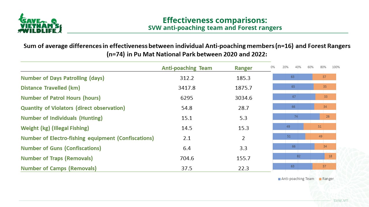
- When directly compared, joint patrols with rangers and anti-poaching team members were shown to be substantially more effective than ranger-only patrols in terms of illegal activity documented and mitigated. This is probably due to the effectiveness of SMART data collection (Figure 2).
- Since anti-poaching members are not government employees like rangers, they do not have the power to make arrests, when necessary, therefore patrols with only anti-poaching members are only able to document but not mitigate active human threats to wildlife.
Spatial Reporting and Monitoring Tool (SMART)
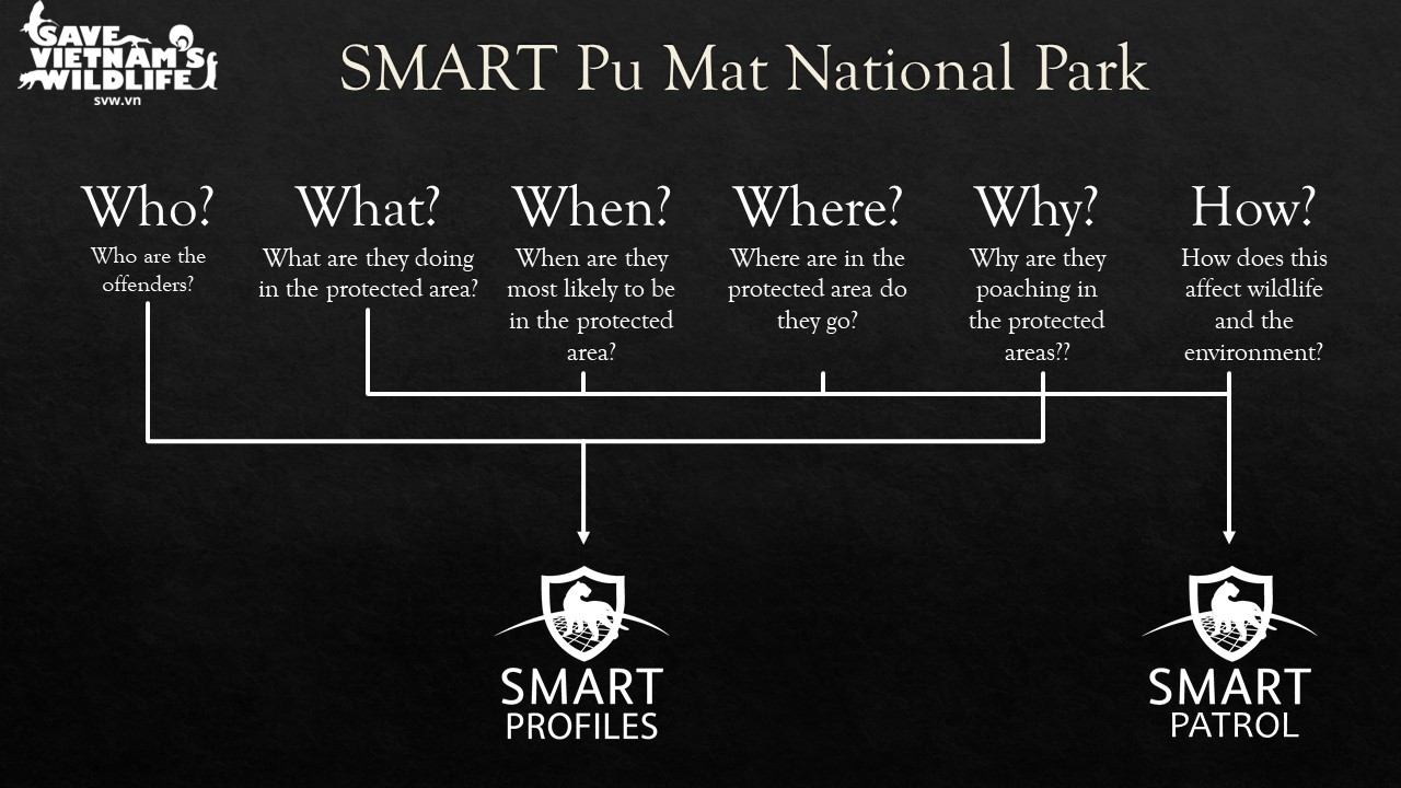
The Spatial Monitoring and Reporting Tool (SMART) is a both a software and a framework that allows forest rangers and anti-poaching patrols to collect geospatial data on their smart phones (via the SMART mobile app), which acts as an advanced handheld GPS. When traps, illegal encampments, animals, or violators are located, the patrol will make a record using the app’s customized “data model” (a customization of the application that creates specific drop-down lists, and decision trees). The SVW data model is based on Vietnamese forestry law, so when any technical gaps are identified in the data model in terms of arrest procedures, non-standard violations, or priority species listed in legislative decrees, it can directly inform and improve policy.
Once data has been collected by patrols on their smart phones, the patrol data (paths walked, km travelled, time spent on patrol, and data recorded) will upload automatically to SMART desktop. This is where managers can evaluate poaching hotspots to apply pressure, and also allows them to monitor the effectiveness of the patrols themselves. With each new data input, data managers are able to adapt to the situation and adjust their team and patrolling regimens accordingly.
Enabling factors
- Cooperation of park managers enabling SVW anti-poaching team to operate in the park
- Rangers willing to learn new technologies and agree with directional planning from younger, newer employees that have less experience and seniority in the protected area.
- Intensive and effective training of anti-poaching teams and willingness of members to perform intensive work in the field collecting data and, in the office, managing and reporting the data outputs.
- Functioning SMART software and available equipment (smart phones)
Lesson learned
- Data managers are vital to the success of intelligence reporting and planning, and should be separate from patrols so they can focus specifically on data management tasks alone. Rangers and team members often forget to turn off their track recorder during breaks, in transit, and after they finish working. As a result, data managers must clip and clean data to maintain reporting accuracy.
- At the learning phase, mistakes are common in the first year of data collection and processing, and are to be expected. It is best to identify the most common errors early on and address them with all participating patrols to ensure data viability moving forward.
- SMART Connect is a solution to centralizing data collected from multiple ranger stations or sites. However, SMART Connect servers require expert technical assistance to set up and maintain. If they are set up through a third-party service, server issues rely on the third-party service technical support, and data sovereignty laws may prevent access to this option altogether.
Resources
PoacherCams
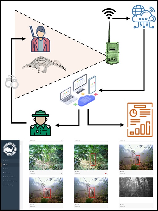
Our anti-poaching teams have improved the workflow of detecting and pre-emptively stopping offenders who illegally enter the protected forest areas by deploying PoacherCams -- automated detection systems that operate via camera traps and artificial intelligence classification of humans, animals, and vehicles (Figure 3). PoacherCams are strategically placed at entry points into protected forests adjacent to local villages and access trails. When the cameras detect a human entering the park at PoacherCam installation sites, the site manager will receive a notification on their Smartphone of the threat and location. The manager will then deploy a mobile unit (forest rangers) to survey the area or document the entry and exit activity of the offender over time and make an arrest. Our system also has a dashboard for record-keeping purposes and note taking which forestry law-enforcement can refer to later when issuing penalties and following up with their issuance with commune-level law enforcement. Through extensive patrolling efforts, we have identified numerous central access points from local villages into the protected forests and set PoacherCams to monitor them and take action where needed.
Enabling factors
- External funding from donors willing to improve site protection efforts in Vietnam protected and conserved areas via new technologies. It is difficult to get government buy-in for new equipment and technology with limited resources until proof of success is achieved.
- Support by Panthera – both in providing us with cameras and technical with assistance setting them up on their server.
- Support by Wildlife Protection Solutions with re-routing camera messages and images to their dashboard and sent to rangers as WhatsApp alerts
- Cellular network connectivity
Lesson learned
- PoacherCams must be well hidden, or set high up in trees, or they will be damaged or stolen
- Cellular network connection is required for the system to send alerts to ranger’s phones, and the weaker the cellular connection, the longer the message will take to be received.
- Sometimes, it is best to observe offenders entering and exiting the forest and record common times of entry/exit to then deploy a ranger to wait for them at the location, rather than deploy rangers immediately when alerts are received.
- Some smart phones cannot communicate with the Camera Trap Wireless Client app required to set up the camera. The app should be tested before leaving to the field
- the nPerf app may help to actively map cellular network connection strength in the field, and provide information on locations to optimize PoacherCam placement.
- Local people are quickly habituated to ranger patrol patterns and have their own communication networks. When local people from the villages see a ranger going toward a trail where the village hunter entered the forest, they will call the hunter and tell him to take another trail so they will not be caught.
Resources
Systematic Camera Trapping
Camera trapping allows non-invasive surveys of wildlife throughout the protected area, providing new insights into hotspots of rare and threatened species, while also providing information on which locations contained the most species targeted by hunters. Systematic camera traps were set in either fine-grid (smaller areas with 1-2 km spacing in between stations), or course-grid (full protected area coverage with ~2.5 km spacing between stations) designs, with stations that contain 2 or more cameras spaced about 20 m from one another. Cameras trapping systems were left in the field for ~3 months for each sample session to meet the closure assumption; fine grid designs for two locations were repeated 2 years apart, the course grid is intended to be reproduced in 2023 (5 years apart). Systematic cameras were set and microhabitat data were collected at each station site following protocols from Abrams et al (2018).
References
Abrams, J. F., Axtner, J., Bhagwat, T., Mohamed, A., Nguyen, A., Niedballa, J., ... & Wilting, A. (2018). Studying terrestrial mammals in tropical rainforests. A user guide for camera-trapping and environmental DNA. Berlin, Germany: Leibniz-IZW.
Enabling factors
- Donor funding to purchase camera traps, batteries, and other necessary equipment
- Assistance by rangers and local people to set camera traps in the field
- Capacity of researchers to properly classify, clean, analyze, and report data.
Lesson learned
- Due to the flash, it is easy for camera traps to be detected and damaged or stolen
- Experienced personnel are needed to coordinate camera trap setting efforts to mitigate errors as much as possible. Common errors include:
- date-time setting issues
- vegetation not cleared from the immediate area of the camera traps causing thousands of blank photos to be triggered by leaves swaying in the wind and rapid loss of battery life, and eventually battery death within days of setting.
- improper setting of camera traps facing toward one another instead of away, causing potential duplicate records
- Forgetting to turn the cameras on
- inconsistent microhabitat data collection by various teams
- Pre-planning for camera trapping is essential to success and reducing errors, pre-planning should include all personnel involved, should be presented on mapped locations, should identify team leaders, and review protocols and checklists.
- Photos should be taken in 4 directions around the camera location. This way if mistakes are made in the field, they can be somewhat mitigated by evaluation of photos later on where possible.
Impacts
- Illegal firearms confiscated per km travelled in 2018-2019 went from 0.016 to 0.003 in 2019-2020 (79.3% Reduction) to 0.001 from 2020 to the end of 2021 (67.6% Reduction)
- Traps removed per km travelled in 2018-2019 went from 1.91 to 0.345 in 2019-2020 (81.9% Reduction) to 0.104 from 2020 to the end of 2021 (69.9% Reduction)
- Illegal encampments removed per km travelled in 2018-2019 went from 0.182 to 0.031 in 2019-2020 (82.9% Reduction) to 0.008 from 2020 to the end of 2021 (74% Reduction)
- Total number of offenders in the protected area per km travelled went from 0.088 in 2018-2019 to 0.0326 in 2020 (62.9% Reduction) to 0.0075 by the end of 2021 (77% Reduction)
- For the entire year of 2021 there were zero illegal logging cases recorded in Pu Mat National Park
- Our successful anti-poaching model is entirely scalable and is now being expanded to four other national parks in Vietnam, with hopes to expand further in the near future.
Beneficiaries
- Rangers in Pu Mat Nation Park
- Managers in Pu Mat National Park
- Wildlife in Pu Mat National Park
Sustainable Development Goals
SDG 13 – Climate action
SDG 15 – Life on land
Story

The first female member of the anti-poaching team in Vietnam: Le Thi Ngoc Lam
CC-BY-NC
Lam was born and grew up in Binh Dinh, where she had been learning martial arts since she was a little girl prior to enrolling in university. According to Lam: “Martial art is not just to protect me but my passion also". Aside from her passion for martial arts, she also has a strong love for the forest. After graduating with a major in forestry, more than anyone, she understood her responsibility to nature, forest, and wildlife, so she chose to follow the conservation pathway. Perhaps the temperament of a martial art practitioner mixed with the empathy for nature ended up triggering the decision to become an anti-poacher at SVW.
In July, 2021, Lam took the opportunity with 9 other colleagues to join the 7-day patrol to Pu Mat National Park. She experienced places and situations she had never ever been in her life. What she shared about that trip that she “… learned survival skills, and [had] a chance to hear and see many new wonderful things". The trip revealed to her all of the upcoming challenges to practice and train herself with determination and tenacity.
While this is how we prefer to describe conservation work, the truth is that all the patrols are not easy. This is an intense and hard-working duty, regardless of who you are, you might feel worn out and discouraged sometimes. “Being a girl is more inconvenient, especially when going for bathing or when you are in “strawberry season", you might not withstand it without patience and a tenacious mind”. And yes, beyond our expectation, this special girl nailed it in her first patrol. She conquered the mountain, passed through the cascade, went through the forest, witnessed the clouds fly under her shoes, walked under the heavy forest rain, and set foot in the slopped trail with a resilient will.
“The patrols brought me valuable experience; you have to go there to see how hard habitat protection efforts are” said Lam. She hopes that people will change their minds and know how to love nature, so all the forests will be a truly safe home for wildlife animals.
Today, Lam has been assigned to a new anti-poaching team that extends from the successful Pu Mat model to scale its implementation in Cat Tien and coordinates the southern region of the national park. She is well versed in patrolling techniques, SMART, data management, reporting, SMART Connect, PoacherCams, and is looking toward new solutions to anti-poaching efforts in the future.