Mapping study of Posidonia meadows in the Cerbère-Banyuls Marine Nature Reserve
Full Solution
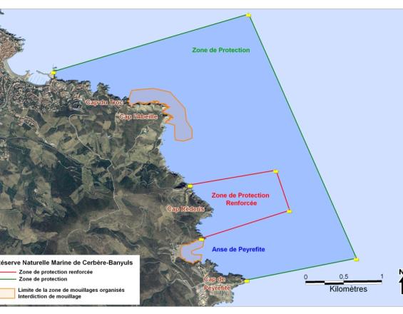
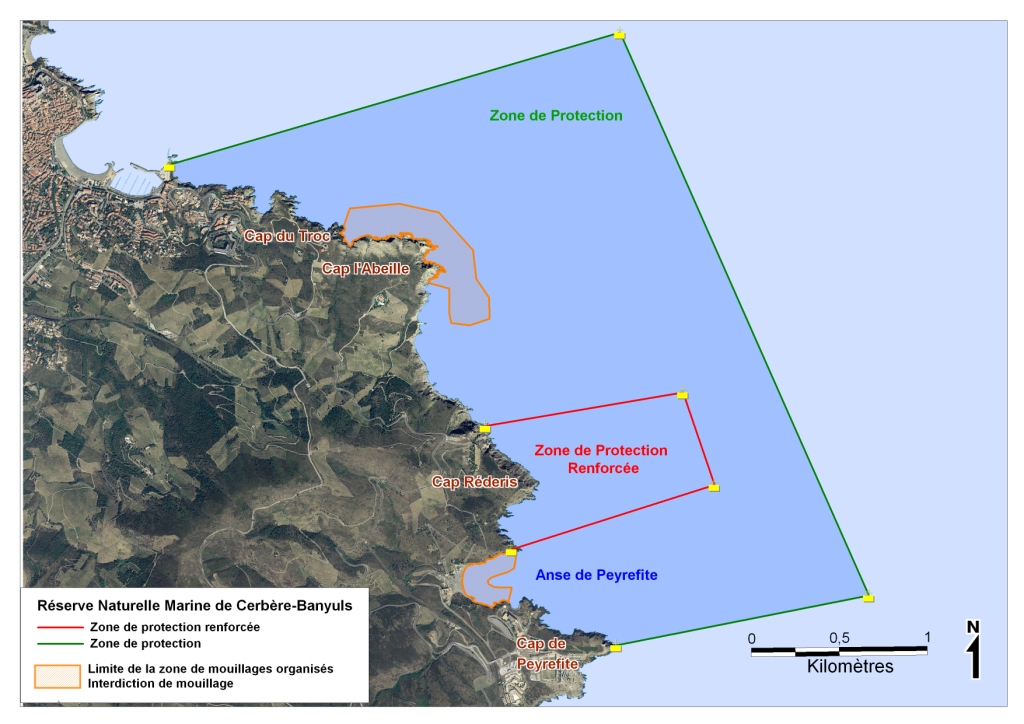
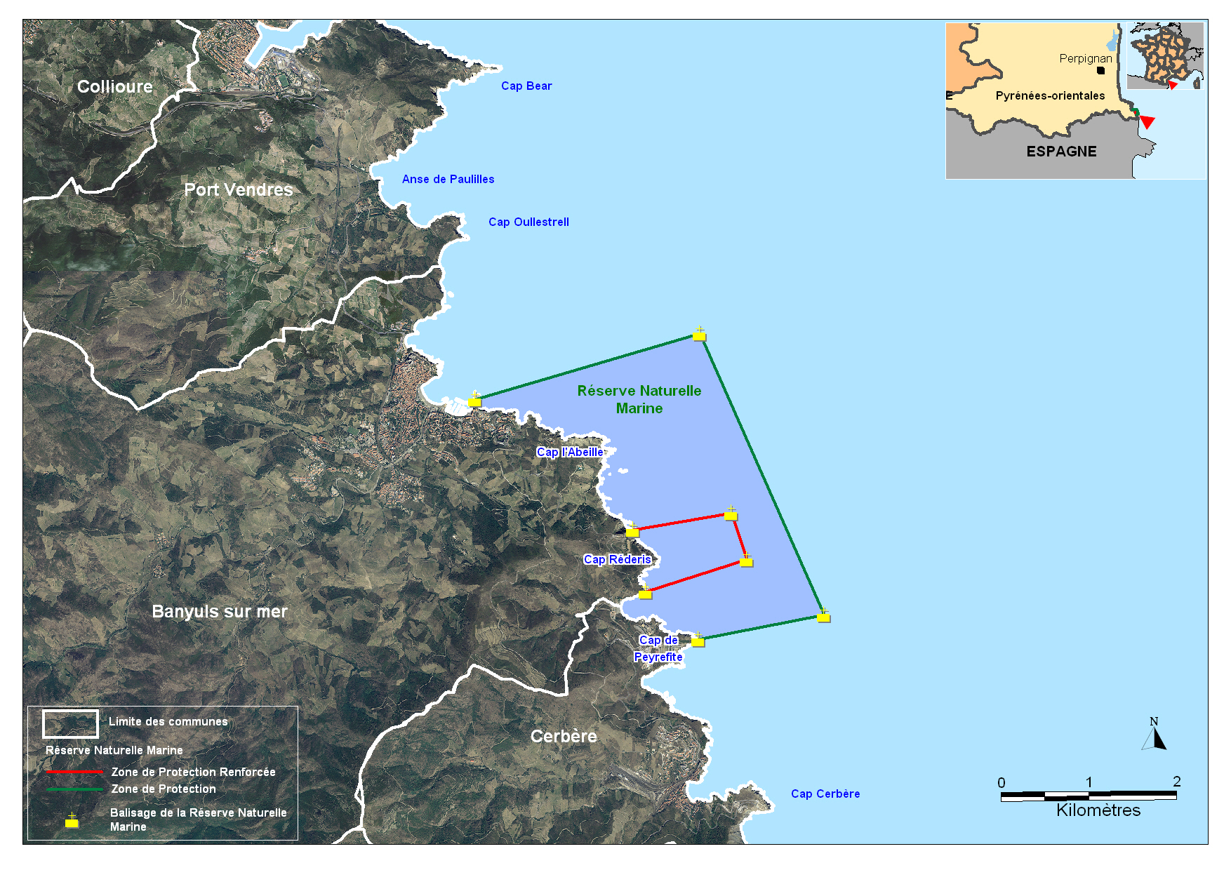
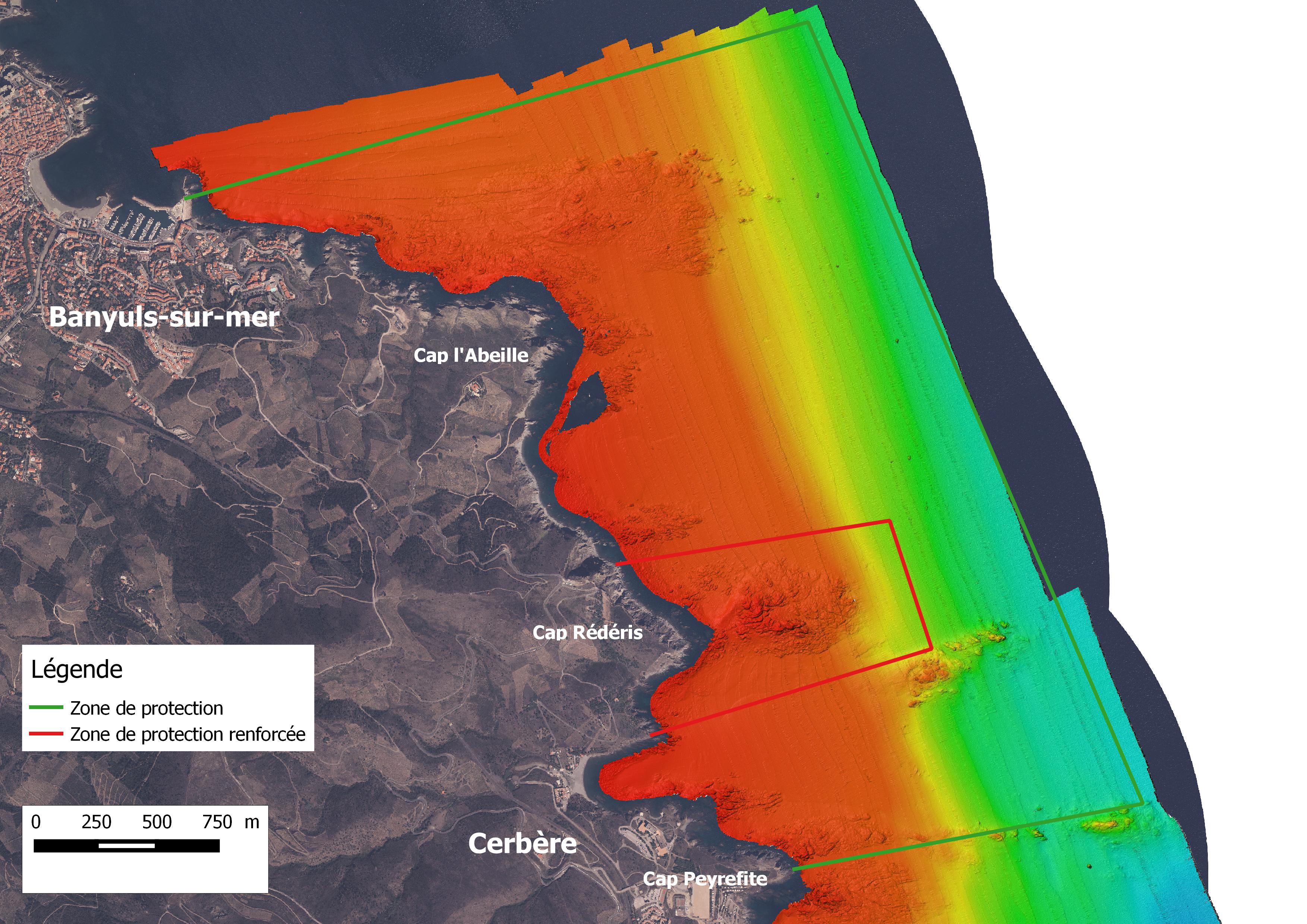
Situation of the Marine Nature Reserve
Réserve Marine
The manager of the Réserve Naturelle Marine de Cerbère-Banyuls wanted to update the mapping of Posidonia meadows, a protected species identified as a priority habitat. This long-term monitoring project, scheduled for 2018 as part of the Reserve's management plan, enabled us to assess the state of conservation of the meadows by integrating new technologies, and also to fill in the gaps observed in the mapping of shallow coastal waters.
The integration of these new technologies was essential to obtain fine maps of our habitats and to be able to compare them over the long term.
The renewal of this study was necessary in order to detect any potential impact on the habitat and propose management measures. This detailed mapping enabled us to measure the evolution of the Reserve's seagrass beds, and to anticipate pressure on this environment by implementing appropriate measures and tools.
Last update: 10 Mar 2020
6106 Views
Photo and video gallery
Context
Challenges addressed
- Gaps in scientific knowledge of Posidonia meadows
- Lack of long-term monitoring of meadow evolution
- Gaps in mapping data for shallow coastal ecosystems
- Limited budget
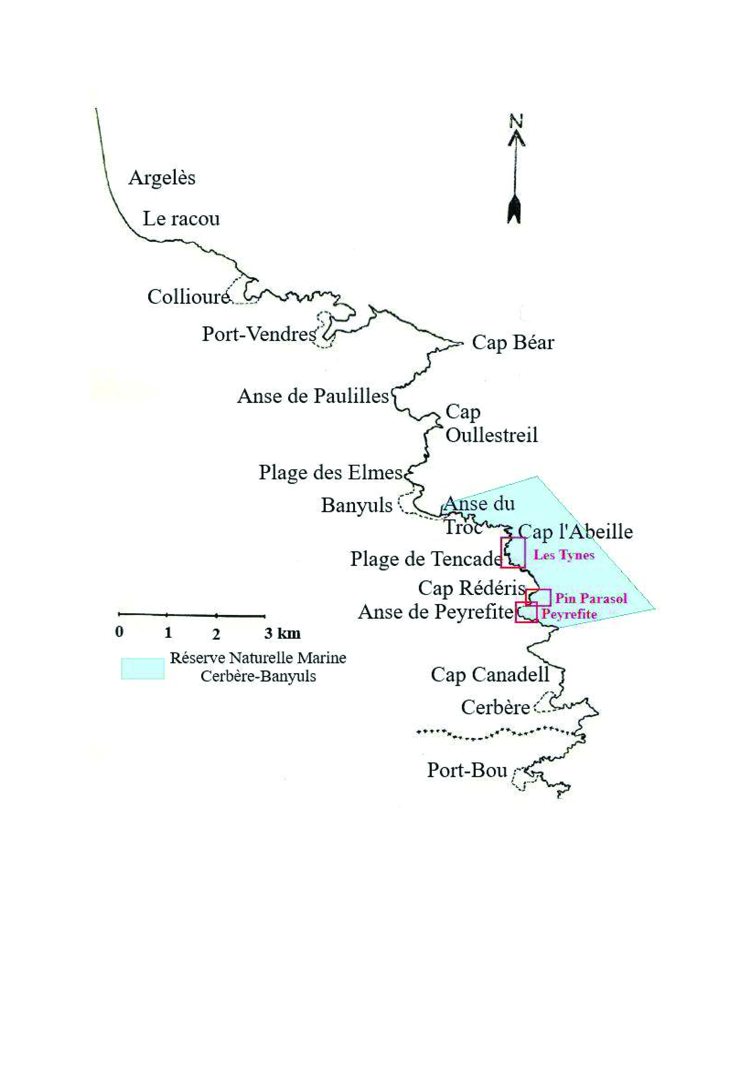
Location
France, Région Occitanie, Département des Pyrénées-Orientales, Commune de Banyuls et Cerbère, Réserve Naturelle Marine
West and South Europe
Process
Summary of the process
The Réserve Naturelle Marine de Cerbère-Banyuls has a management plan which includes the need to complete data on Posidonia meadows. Numerous exchanges within the Reserve's Scientific Council enabled us to validate precise specifications, define the results expected from this monitoring and also identify the partners capable of meeting these objectives. The University of Perpignan was chosen as a partner because of its knowledge of the area and its ability to take account of the specific environment in our region (high turbidity, wind, etc.). What's more, the University of Perpignan was able to use a variety of methods to fill the gaps identified. The combined use of side-scan sonar, GPS and drone, coupled with ground truth, enabled us to obtain surface data for the various locations studied and to map them, thus accurately determining their evolution.
Building Blocks
Setting up a partnership for the cartographic study
The University of Perpignan is a long-standing partner of the Reserve, and a number of academics are members of the Reserve's Scientific Council and are regularly involved in numerous monitoring projects. They took part in the drafting of the latest 2015-2019 management plan, helping to define the manager's expectations and responses to the various problems encountered. The proximity of the site makes the Reserve a veritable open-air laboratory for these researchers. The University of Perpignan had already mapped the Reserve's rocky substrates in 3D to an accuracy of 30 cm (see PJ). This mapping enabled us to gain a better understanding of the area and adapt the means used to obtain results of such precision. Thanks to this knowledge of the terrain, our mastery of this technical equipment and the expectations of the Gestionnaie through precise specifications, we were able to obtain an appropriate and fair price for this monitoring project.
Enabling factors
It was important to identify the partners capable of meeting the manager's expectations. The numerous monitoring projects carried out in this field have enabled us to adapt the objectives and fill in the gaps left by previous studies. The partners' knowledge of the field helped us to carry out this study. Last but not least, the mastery of the various tools used during the study enabled the monitoring to be carried out in an optimal manner.
Lesson learned
A large number of upstream exchanges were necessary to carry out this monitoring. New technologies have made it possible to fill in the gaps identified in previous studies. Thanks to these new resources, it was necessary to identify the right partners from the outset. This preparation enabled us to target expectations and thus reduce the cost of monitoring.
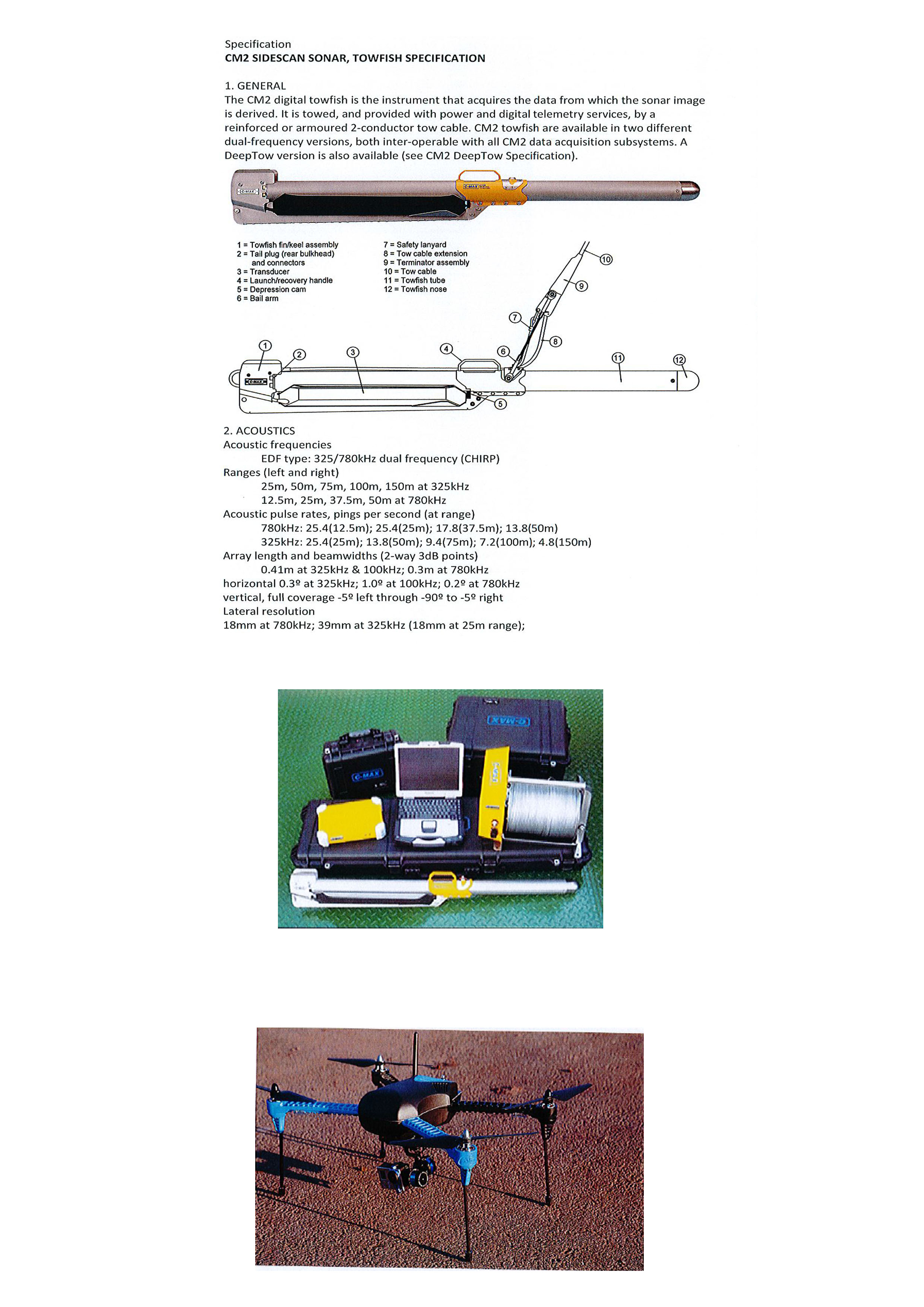
Use of side-scan sonar to map seagrass beds in the Cerbère-Banyuls Marine Nature Reserve
For several years now, numerous studies have been carried out on Posidonia meadows in the Reserve. Each study provided increasingly accurate results, but left a number of gaps. The Reserve decided to fill these gaps by simultaneously using several innovative systems, such as side scan sonar (SBL). This sonar provided an overview of the characteristics of the seabed. The integration of Acoustic Systems for Automatic Bottom Classification (SACLAF) data from previous missions into this project will have been a complementary means to the acoustic scanning imaging system, providing an element of data validity. The reliability of the results was assessed using GoPro® cameras. All data were processed using ArcGIS version 10.3 geographic data processing software.
Enabling factors
Acoustic data were acquired using a C-MAX CM2 EDF side scan sonar and processed using Hypack 2012 software. In order to obtain the expected results, i.e. precise mapping of the Reserve's seagrass beds and a comparison of the evolution of the seagrass beds in relation to the last surveys, perfect knowledge of this equipment and of the study area is required.
Lesson learned
- Regular exchange and sharing with service providers
- Competence of equipment users
- Ability to process data
- Realization of ground truth
Implementation of a GPS navigation system
During this survey, the Nature Reserve's launch was made available to study the shallow coastal waters. With a length of 8 meters
equipped with sounder, GPS and radar. To complement this equipment and obtain the finest possible accuracy, the launch was equipped with a differential GPS operating in real-time WAAS/EGNOS metric mode, with an accuracy of the order of 1 to 2 meters. An RTK (Real Time Kinematic) system was used for greater precision during the investigations. Its beacon was placed on the roof of the Cap Béar semaphore, close to the survey area. This is a method whereby GPS signal corrections are transmitted in real time from a reference receiver, located at a precise known point, to the boat's mobile receiver. Accuracy can then be
centimeters if you are close to the reference receiver.
Enabling factors
It is essential to identify the partners who can meet the objectives set by the manager. Appropriate resources and local knowledge are also essential to avoid wasting time. Regular exchanges with the partners involved in the project will help to obtain answers and anticipate problems.
Lesson learned
It is essential to define very precise specifications so that the monitoring meets the expectations of the service provider, but also so that the use of these new technologies does not distort the comparison with the results obtained during previous monitoring.
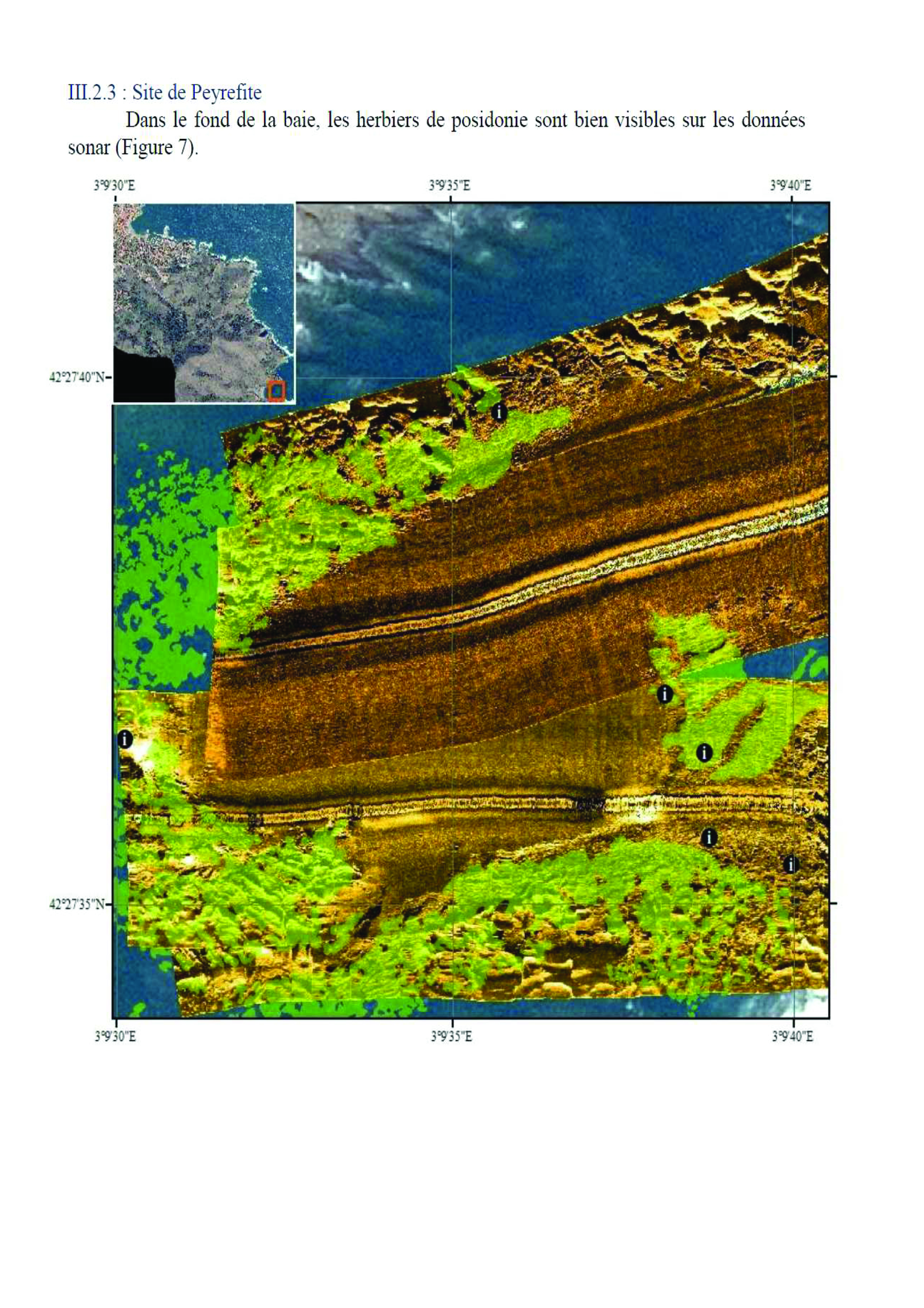
Use of a drone to complete the mapping of the Reserve's shallow waters
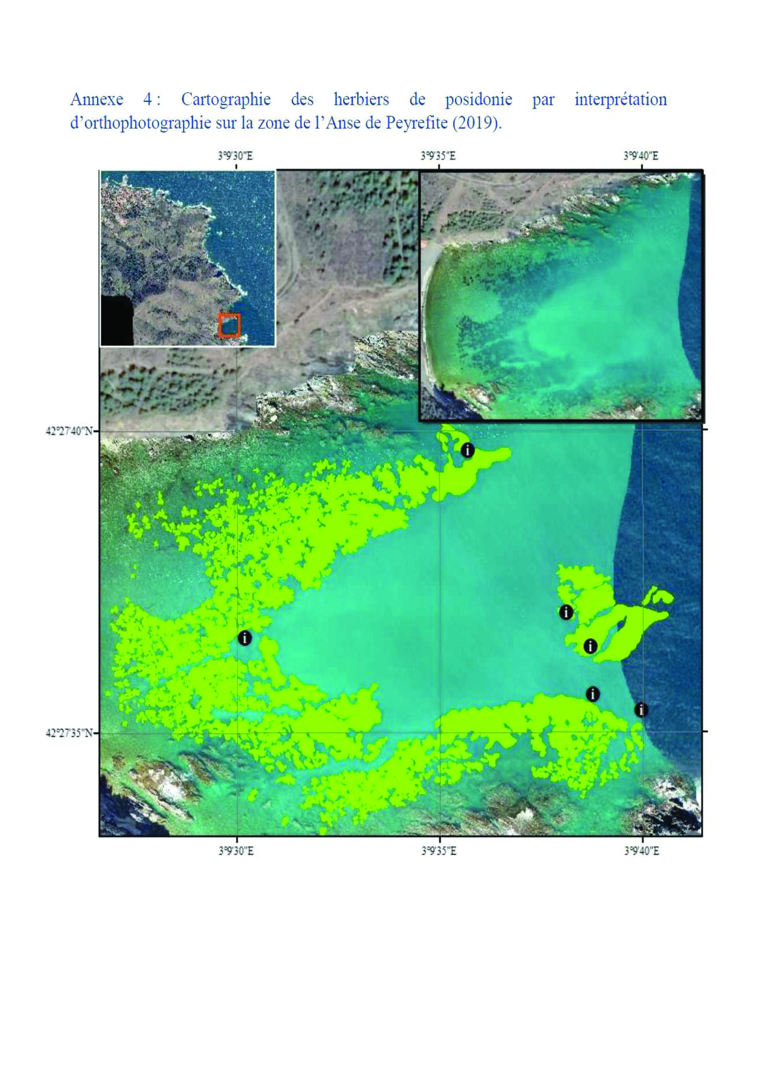
The shallow depth near the coast precluded the use of sonar in these areas, which have sufficient water transparency to allow remote sensing. In order to complete the mapping of the shallow waters during this survey, the use of a Phantom 4MD drone during one outing enabled a clear interpretation of the Peyrefite area in terms of Posidonia, particularly in view of its shallow depth. A second outing enabled us to obtain further orthophotos along the "Tynes" coast. Due to lack of time and poor weather conditions, the Pin Parasol area did not benefit from orthophotos. Using a drone, we were able to obtain an orthophoto that accurately revealed seagrass beds or dead matte through water transparency.
Enabling factors
The choice of using these systems is due to the characteristics of the study sites. The Albères coast has one of the lowest water transparency levels in the Mediterranean. The combined use of these three monitoring systems made it possible to obtain surface data for the various locations and thus determine their evolution. Knowledge of the area also contributed to the smooth running of the monitoring program.
Lesson learned
It is necessary to adapt the equipment to the different conditions of the study area. For this survey, the combination of the 3 pieces of equipment was validated for 2 of the 3 sites. The third site, where the meadow was the deepest, did not allow the use of the drone. However, the 2 other methods, combined with ground truthing, produced very satisfactory and complementary results.
Impacts
Posidonia meadows, with all their important natural functions, represent major socio-economic challenges and real benefits for human communities. On the one hand, a meadow in good ecological condition encourages an increase in biodiversity and consequently the development of activities linked to the discovery of this environment, such as snorkelling, with the possible creation of underwater trails or the development of scuba diving. In addition, a healthy seagrass bed can greatly reduce beach erosion (less submergence and retreat of the coastline), thus avoiding costly beach restoration work for public authorities. Meadow monitoring data has enabled the Reserve manager to implement measures to protect these habitats, notably through more precise management plans, and thus perpetuate their ecosystem services for man and nature.
Beneficiaries
- Manager
- Scientists
- Users of the Réserve Naturelle Marine de Cerbère-Banyuls, such as boaters and divers
Sustainable Development Goals
SDG 14 – Life below water
Story

Acoustic telemetry 2012
Réserve Marine
Posidonia meadows are a pivotal ecosystem on the Mediterranean seabed. They are a zone of nutrition, reproduction (spawning grounds and nurseries), recruitment and shelter for numerous species of fish and invertebrates. They generate high oxygen production (around 4.2 tonnes of O²/hectare/year), forming the basis of numerous trophic chains. They also cushion the hydrodynamic effects of swell (combating beach erosion) and are excellent indicators of water quality.
Knowledge of Posidonia meadows has therefore always been a priority objective for the Cerbère-Banyuls Marine Nature Reserve. The lower limit of the meadows in the Reserve has been monitored since the 1980s. As early as 1999, the habitats were mapped as part of the first management plan. This mapping was carried out using scuba-diving surveys based on around a hundred transects. Between 2003 and 2006, acoustic telemetry, a kind of underwater GPS consisting of a measurement base and mobile pointers, was used to study the lower limit of the various Posidonia meadows and monitor its evolution, thus reflecting the progress or regression of the ecosystem. At the time, this was an innovative methodology. At its lower limit, the seagrass appeared to be heavily healed and of low mechanical strength. However, density measurements within the meadow were normal. The development of the meadow was therefore limited by the site's extreme hydrodynamic conditions, but no trace of regression was detectable at the lower limit (no dead matte).
The results were rather encouraging in terms of the state of conservation of the meadows, but the manager of the Marine Reserve wanted to find innovative solutions in order to continue to better understand the state of conservation of the Posidonia meadows. New technologies such as sonar and drones were tested to improve the quality of data on this habitat. Today, the results are highly satisfactory, providing an accurate picture of the state of health of the Reserve's meadows.