New tool for interpretation of rangeland monitoring and assessment results
Snapshot Solution

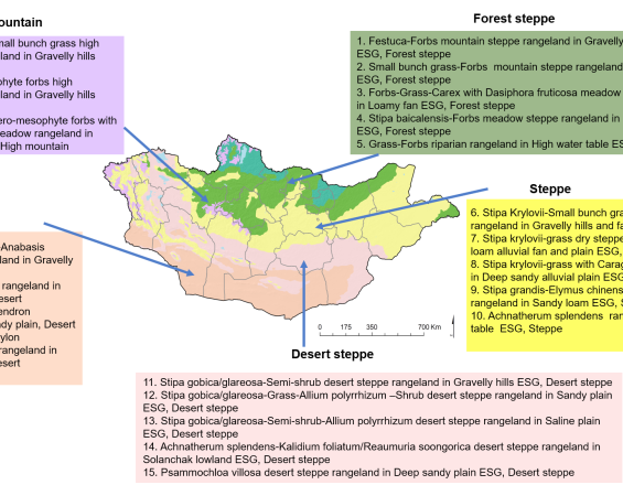
Figure 1. A map of the classification of the rangelands of Mongolia into 22 ESGs
© Bulgamaa Densambuu, Sumjidmaa Sainnemekh, Brandon Bestelmeyer, and Budbaatar Ulambayar. 2018. National report on the rangeland health of Mongolia: Second Assessment. Green Gold-Animal Health Project, SDC. Ulaanbaatar.
To assess a national rangeland health that incorporates variations in ecological potential across Mongolia, a standardized catalogue titled “State and transition model” was developed. The models rely on information and assumptions regarding the reference condition or ecological potential of a rangeland area, as well as the potential shifts to alternative states influenced by management changes and two-way drivers.
The models are built on real field data and expert knowledge. They include information on important plant species, expected productivity, and recommendations for sustainable livestock numbers.
Overall, the model provides not only a snapshot of the current condition and productivity of Mongolia’s rangelands but also clear insights into their risks of degradation and their potential for recovery.
Last update: 31 Oct 2025
251 Views
Photo and video gallery

Impacts
The State and Transition Model of Mongolian Rangelands is a tool used to track and understand how rangelands change over time. It is applied through the National Grazing Impact Monitoring Network and the National Meteorology Network’s ecosystem monitoring program.
The model helps answer the following essential questions:
- How do rangelands respond to use?
- What risks of degradation come from poor management?
- What potential do rangelands have to recover if use is adjusted?
By combining field data with expert knowledge, the model describes:
- The model explains the healthy and degraded states of various rangeland types, as well as how they transition from one to another.
- Key indicator plant species, their cover, and productivity.
- Practical guidance on sustainable grazing levels and management practices.
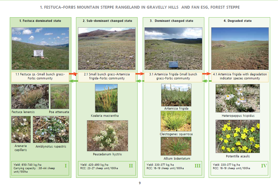
The model is regularly updated and improved using new monitoring results. For example, in the Festuca–Forbs mountain steppe rangeland (common in the forest-steppe zone), four main states are identified: healthy, sub-dominant altered, dominant species altered, and degraded. Monitoring data on plant cover and thresholds between phases are used to classify plots into the right state.
Overall, the model provides not only a snapshot of the current condition and productivity of Mongolia’s rangelands but also clear insights into their risks of degradation and their potential for recovery.
Global Biodiversity Framework (GBF)
GBF Target 1 – Plan and Manage all Areas To Reduce Biodiversity Loss
GBF Target 6 – Reduce the Introduction of Invasive Alien Species by 50% and Minimize Their Impact
GBF Target 8 – Minimize the Impacts of Climate Change on Biodiversity and Build Resilience
GBF Target 11 – Restore, Maintain and Enhance Nature’s Contributions to People
GBF Target 16 – Enable Sustainable Consumption Choices To Reduce Waste and Overconsumption
GBF Target 21 – Ensure That Knowledge Is Available and Accessible To Guide Biodiversity Action
GBF Target 23 – Ensure Gender Equality and a Gender-Responsive Approach for Biodiversity Action
Sustainable Development Goals
SDG 3 – Good health and well-being
SDG 12 – Responsible consumption and production
SDG 13 – Climate action
SDG 15 – Life on land