
Scanneredge-Onepager
Hack The Planet
Mobile phones play a central role in poaching operations, for communication between poaching teams and extraction of illegal goods like rhino horns/elephant tusks.
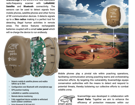
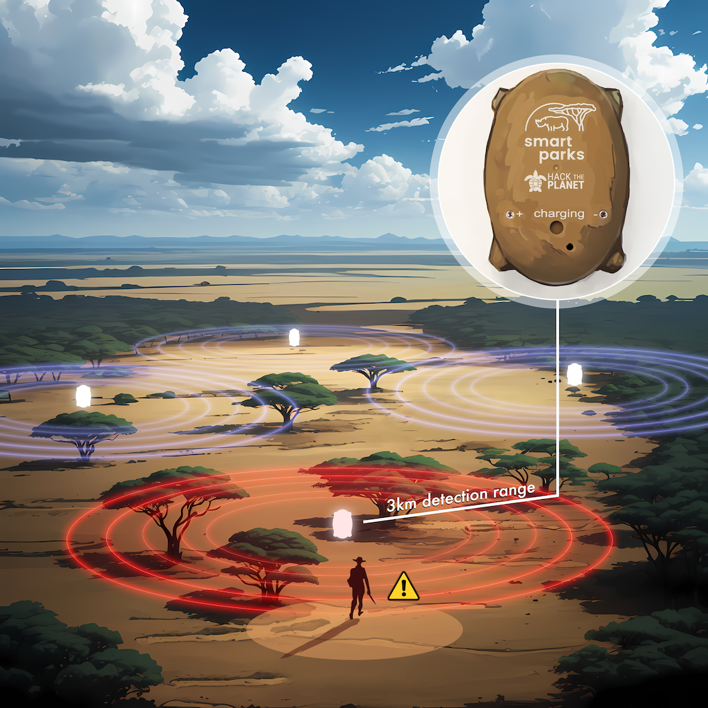
ScannerEdge detects signals from mobile phones, satellite phones, and other RF communication devices, providing conservation authorities with real-time data to identify potential threats. This makes it an ideal tool for uncovering illegal human activity in remote areas.
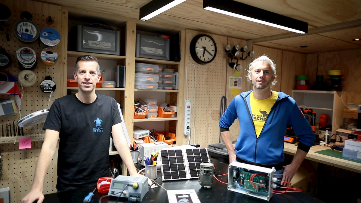
ScannerEdge is the world's first field-deployable radio frequency scanner with LoRaWAN/satellite and Bluetooth connectivity. ScannerEdge
Within five years, this technology could be rolled out globally in more than 50 African and Asian national parks. ScannerEdge is actively contributing to protecting endangered animals, thus to the long-term health of our global ecosystem
‘Fewer of our eco-guards will die, and more poachers will be caught, if we can deploy this technology’ - Lee White, Gabonese minister of Nature"
Scanneredge is proudly the winner of several LOVIE AWARDS and Wubbo Ockels Price 2024
Last update: 31 Oct 2025
208 Views

Context
Challenges addressed
Main Challenge (Environmental, social and economic)
Poaching poses a critical threat to wildlife across the globe, driving many species toward extinction.
In recent years, poaching has become more organized and technologically advanced, fueled by high market demand and lucrative black-market profits. Species like elephants, rhinos, and pangolins are particularly targeted. For example, African elephant populations have plummeted due to ivory poaching, with approximately 20,000 elephants killed annually. Similarly, rhino populations face a steep decline, especially in South Africa, where poaching rates remain alarmingly high despite increased security measures.
Economic challenge
- Limited budgets of national parks make it challenging to allocate resources for investing in new technologies.
Environmental Challenge
- Remote area's makes it very hard for Rangers to detect poachers. For example: 200 rangerunits are guarding area's as big als The Netherlands and Belgium combined.
Location
Gabon
West and Central Africa
North Africa
East and South Africa
North and Central Asia
West Asia, Middle East
Southeast Asia
South Asia
East Asia
Process
Summary of the process
In order to successful install and use the ScannerEdge against anti-poaching activities the following building blocks are essential:
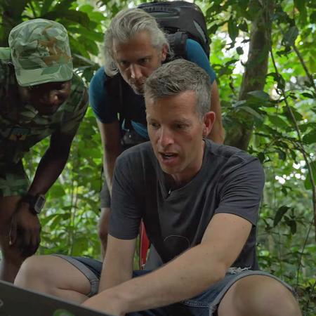
- Technical Installation and Training: Ensuring that ScannerEdge devices are properly installed and configured in the field, with thorough training for operators to maximize their effectiveness in detecting illegal human activities.
- Mobile/Satellite Phone Monitoring: ScannerEdge specializes in monitoring RF signals from mobile and satellite phones, as well as other communication devices, to detect human activity in remote areas.
- Quick Response Unit(QRU) acting on suspicious threats based on real-time data: Leveraging real-time alerts from ScannerEdge, a response unit can quickly assess and mitigate potential threats, such as poaching or other illegal activities. The technical installment and strategic placement of building blocks 1&2 are essential for the QRU
- Building cross-sectoral Partnerships: Scanneredge is a collaboration with with Smartparks, Management of national parks, park technicians, rangers(QRU) and the local community. Through this cross-sector partnership, we have demonstrated that ScannerEdge is ready for broader deployment, increasing the number of active national parks and total scanners in use.
Building Blocks
Technical Installation and Training
Ensuring that ScannerEdge devices are properly installed and configured in the field, with thorough training for operators to maximize their effectiveness in detecting illegal human activities.
Enabling factors
Purpose: To equip field teams with the skills and knowledge to install, operate, and maintain ScannerEdge devices, ensuring continuous functionality in diverse environments.
How it Works: ScannerEdge is installed in strategic locations, configured via Bluetooth through a smartphone app, and calibrated to local RF conditions. Training includes understanding signal detection, troubleshooting, and device maintenance.
Lesson learned
On-site, hands-on training yields better outcomes than theoretical sessions alone.
Operators need to understand both the technical and practical implications of the data collected.
Regular follow-ups improve long-term device functionality and user confidence.
Mobile/Satellite Phone Monitoring
ScannerEdge specializes in monitoring RF signals from mobile and satellite phones, as well as other communication devices, to detect human activity in remote areas.
Enabling factors
Purpose: To provide real-time intelligence on human presence or illegal activities by detecting and analyzing RF signals within a 3 km radius.
How it Works: ScannerEdge scans for RF signals (UMTS, Wi-Fi, Bluetooth, satellite phones, and VHF radios) and transmits alerts via LoRaWAN or satellite connectivity. Data is centralized for further analysis and decision-making.
Lesson learned
ScannerEdge’s ability to integrate with multiple communication networks LoRa/Satellite ensures reliable data transmission even very remote regions.
Satellite data transmission, while robust, can be cost-prohibitive and requires funding models that accommodate operational expenses.
Proper calibration to filter false positives is critical for actionable intelligence.
Quick Response Unit acting on suspicious threats based on real-time data
Leveraging real-time alerts from ScannerEdge, a response unit can quickly assess and mitigate potential threats, such as poaching or other illegal activities.
Enabling factors
Purpose: To translate RF signal detection into actionable insights that trigger swift response actions in the field.
How it Works: Alerts are routed to dedicated response teams equipped to investigate and intervene. ScannerEdge’s GPS functionality and integration into EarthRanger aids in pinpointing signal sources for precise action.
Lesson learned
Response protocols must be clearly defined to avoid delays in decision-making.
Collaboration with local enforcement agencies enhances the effectiveness of rapid response teams.
Real-time response is more effective when combined with predictive analytics based on historical ScannerEdge data.
Building Cross sectoral Partnerships
Hack The Planet acknowledge that our partnerships allow us to combine strengths, resources, and expertise, amplifying the impact and fostering innovative solutions. Collaborating creates shared value and builds networks, enabling mutual growth and sustainability.
Local involment:
The scanners send real-time alerts to the anti-poaching control room. These alerts can also be shared with local communities or neighboring farms, enabling them to act as third-party partners in anti-poaching efforts. By involving locals directly in the response process, the system fosters collaboration, increases situational awareness, and empowers communities to take an active role in protecting wildlife.
Scanneredge is a collaboration with Tech for Conservation organisation Smartparks, Management of national parks like Gonarezhou - Zimbabwe, park technicians, rangers(QRU) and the local community. Through this cross-sector partnership, we have demonstrated that ScannerEdge is ready for broader deployment, increasing the number of active national parks and total scanners in use.
Enabling factors
To establish a successful cross-sector partnership, it is essential to clearly define each partner's role and level of involvement from the outset. Ensuring local ownership of the solution is crucial for achieving long-term sustainability and impact.
Purpose: To align resources, expertise, and strategic goals across different sectors for effective implementation and operational success.
How it Works: Partnerships are built through workshops, shared missions, and transparent agreements outlining roles and responsibilities. Regular evaluations ensure partnerships remain productive.
Lesson learned
Scanneredge offers a plug&play innovation offering a quick installation that can be monitor the area for signs of potential poachers immediately after installation.
The true success depends on the internal Rangers Quick Response Unit's ability to act swiftly and effectively on the real-time data provided. The unit must remain on constant standby, equipped with reliable transportation, and prepared to respond on poaching activity.
Building trust among stakeholders takes time but is essential for long-term collaboration.
Cross-sectoral partnerships increase funding opportunities and knowledge sharing, enhancing the overall impact.
Impacts
The ScannerEdge has already demonstrated its effectiveness during our pilot project in Zambia, where it sussesfully proved its capability to identify human presence in protected areas.
To measure the impact of the ScannerEdge technology, we have implemented several key performance indicators (KPIs) and monitoring strategies:
- Detection Accuracy: During our pilot project in South Luangwa(Zambia), the ScannerEdge devices successfully detected the presence of ranger teams, demonstrating the device's accuracy in identifying human activities within its detection radius.
- Response Time: We track the time the Quick Reaction Force takes to respond to detected incursions. The aim is to ensure that any potential illegal activities are quickly intercepted, thus preventing harm to wildlife.
- Event Logs and Data Analysis: Each detection event is logged and analyzed to identify patterns in illegal activities. This data is crucial for adjusting deployment strategies and improving the overall effectiveness of the technology.
- Operational Reliability: The continuous, uninterrupted operation of the ScannerEdge devices in the field, powered by their solar capabilities, measures their reliability and suitability for long-term conservation efforts.
These measures provide concrete evidence of the technology's impact in the field, supporting its potential to significantly enhance conservation effo
Beneficiaries
‘Fewer of our eco-guards will die, and more poachers will be caught, if we can deploy this technology’ - Lee White, Gabonese minister of Nature
Beneficiaries
- Endangered species like the Elephant and Rhino
- Rangers
- Park Management
- Local Community
Additionally, explain the scalability potential of your Solution. Can it be replicated or expanded to other regions or ecosystem?
The ScannerEdge technology is highly scalable and adaptable to various conservation contexts beyond anti-poaching efforts in Zambia. Here’s how it can be scaled and the challenges we anticipate:
- Scalability: We plan to expand our current pilot-deployment from 4 to 20-30 sensors across larger areas of South Luangwa National Park. By integrating a LoRaWAN network, we can reduce reliance on satellite connectivity, making the technology more cost-effective and easier to scale across other regions and national parks globally.
- Adaptability: The ScannerEdge can be customized to detect various communication frequencies, making it applicable in different conservation settings, from monitoring illegal logging operations to preventing unauthorized fishing activities in marine protected areas.
Challenges and Solutions:
- Cost of Deployment: The initial cost of deploying a large number of sensors and setting up a LoRaWAN network can be high. However, by leveraging grant funds and building partnerships with local conservation organizations, we can offset these costs.
- Technical Training: Ensuring that local teams can operate and maintain the technology effectively is crucial. We plan to provide comprehensive training and develop user-friendly interfaces to facilitate ease of use.
- Infrastructure Limitations: In regions with limited infrastructure, setting up a reliable LoRaWAN network may be challenging. We would address this by conducting thorough site assessments and working with local tech providers to establish the necessary infrastructure.
By addressing these challenges, we can successfully scale the ScannerEdge technology to protect wildlife and their habitats across the globe.
Global Biodiversity Framework (GBF)
GBF Target 1 – Plan and Manage all Areas To Reduce Biodiversity Loss
GBF Target 2 – Restore 30% of all Degraded Ecosystems
GBF Target 3 – Conserve 30% of Land, Waters and Seas
GBF Target 4 – Halt Species Extinction, Protect Genetic Diversity, and Manage Human-Wildlife Conflicts
GBF Target 8 – Minimize the Impacts of Climate Change on Biodiversity and Build Resilience
GBF Target 9 – Manage Wild Species Sustainably To Benefit People
GBF Target 14 – Integrate Biodiversity in Decision-Making at Every Level
GBF Target 20 – Strengthen Capacity-Building, Technology Transfer, and Scientific and Technical Cooperation for Biodiversity
GBF Target 21 – Ensure That Knowledge Is Available and Accessible To Guide Biodiversity Action
Sustainable Development Goals
SDG 9 – Industry, innovation and infrastructure
SDG 12 – Responsible consumption and production
SDG 13 – Climate action
SDG 15 – Life on land
SDG 17 – Partnerships for the goals
Story
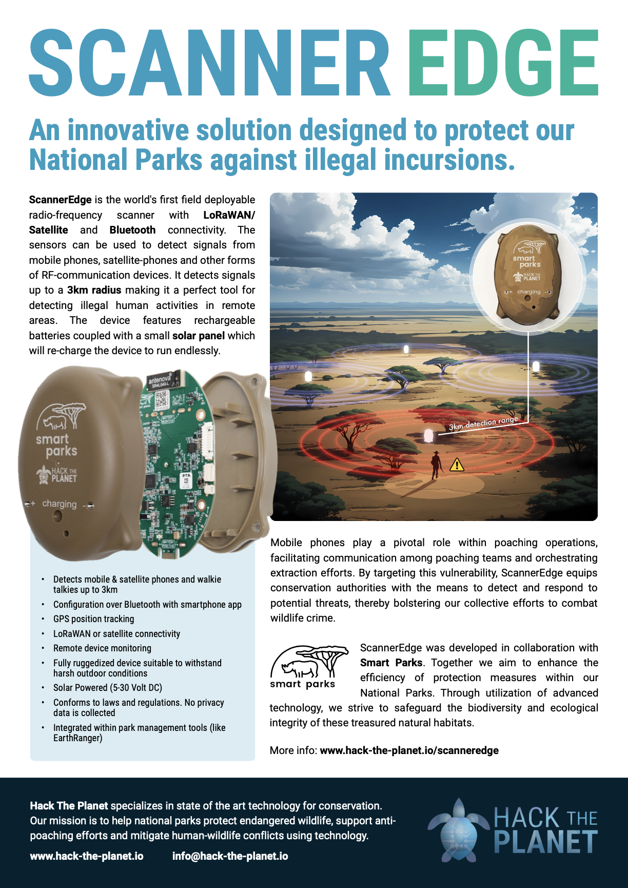
Tim van Deursen - Founder HTP
HTOP
It all began in the heart of a problem that felt as vast as the wilderness itself. I remember standing on the edge of a reserve, the sun casting long shadows over the savanna, knowing that somewhere out there, unseen forces were working against us. Poachers, equipped with tools as sophisticated as those of the protectors, were devastating wildlife populations. Each year, hundreds of endangered animals fell victim, not just to greed but to a lack of real-time intelligence that could empower conservationists to act.
The traditional solutions felt inadequate—camera traps that recorded moments long after they happened, rangers left to cover immense areas of terrain, and a glaring gap between data collection and actionable insights. As I looked at the vast landscape before me, I asked myself, “Why can’t we just know where they are before they strike?” That question stayed with me. It haunted me. If poachers could communicate with such ease using mobile and satellite phones, why couldn’t we turn their strength into their weakness?
The answer lay in technology—a tool to level the playing field. Alongside a small but passionate team, I began sketching out an idea: a portable device that could scan for RF signals and identify human activity in real time, even in the most remote locations. The concept evolved rapidly, driven by urgency and the potential to save lives—both animal and human. We imagined a solution that didn’t just react but predicted, detected, and empowered.
ScannerEdge was born from that vision. The first field deployment was both nerve-wracking and exhilarating. We installed the device in an area plagued by frequent poaching incidents. For the first time, rangers began receiving real-time alerts when RF signals from mobile or satellite phones were detected in restricted areas. This meant they no longer had to constantly patrol vast stretches of land without knowing where threats might arise. Instead, they could monitor the park remotely, focusing their efforts where they were truly needed. Even at night, ScannerEdge became their eyes, watching over the park when human eyes couldn’t.
This isn’t just a story about a device. It’s about people. Rangers who now feel empowered to protect their parks more effectively. Communities that see the return of wildlife tourism, bringing jobs and stability. A world that feels just a little less helpless in the face of environmental destruction.
ScannerEdge isn’t the end of the story; it’s the beginning of a new chapter
Tim van Deursen : founder