Triple Level Digital Monitoring (3LDM) - Remote sensing and IT solutions for monitoring Forest Landscape Restoration (FLR)
Full Solution
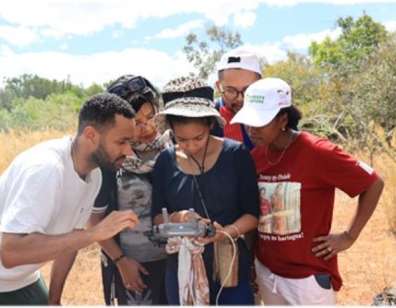
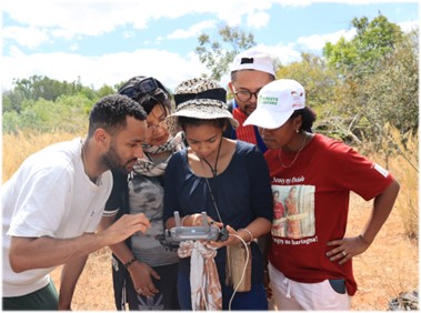
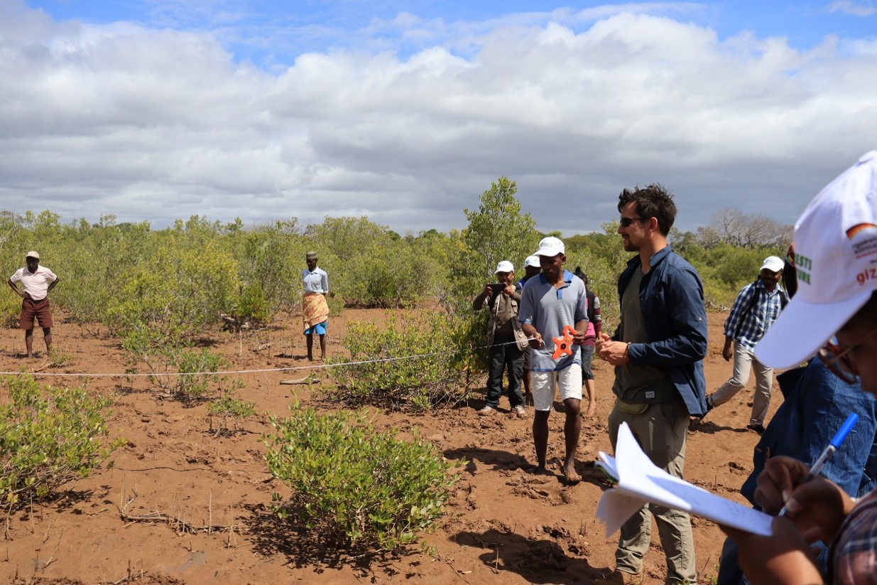
Drone training in Madagascar
© Forests4Future, GIZ
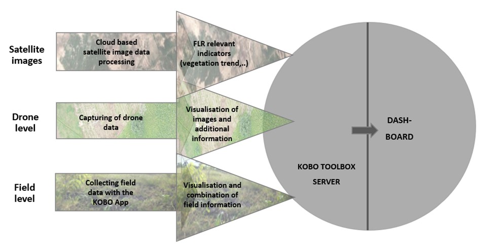
The GIZ's Forests4Future (F4F) project champions Forest Landscape Restoration (FLR) and governance in countries like Ethiopia, Madagascar, and Togo. Current FLR monitoring systems face issues of accuracy and completeness. To address this, F4F initiated the development of a reliable monitoring system and piloting a standard operating procedure. Leveraging expertise from external geospatial data firms, F4F introduced the Triple Level Digital Monitoring System (3LDM). This system refines monitoring, integrating threee levels of data:
1. Field-based data
2. Drone-based data
3. Satellite data
The 3LDM approach tracks hectares restored, above ground tree biomass, and tree diversity on selected FLR sites
Last update: 30 Sep 2025
1015 Views
Photo and video gallery
Context
Challenges addressed
Environmental challenges:
Satellite imaging, such as Sentinel or Landsat, can miss smaller trees due to low resolution affecting accurate forest evaluation, especially for young growth or under-canopy. The 3LDM system, using high-resolution drone data, measures canopy height and with allometric equations, refines biomass calculations. Drones, surveying extensive areas, enhance data accuracy and efficiency.
Social challenges:
Traditional forest monitoring demands manual labor, posing disruptions for local communities. 3LDM, harnessing drone and satellite tech, monitors expansively with minimal intrusion, preserving local customs. It also fosters local drone-related skill development and job opportunities.
Economic challenges:
Manual forest inventory is costly and slow. 3LDM provides an economical solution. Drone data collection, being quicker and expansive, reduces fieldwork costs. Using open-source imagery curbs expenses, rendering monitoring affordable and adaptable for diverse projects.
Location
Madagascar
Ethiopia
Togo
West and Central Africa
East and South Africa
Process
Summary of the process
The intricate synergy of the three data collection mechanisms—field data, drone imagery, and satellite captures—serves as the backbone of our program's monitoring framework. Each mechanism brings a unique strength to the table: while field data offers granular insights at ground level, drone imagery provides a detailed aerial perspective, and satellite captures give a broader overview from space. When interwoven, they create a robust tapestry of data that bolsters data reliability and accuracy.
This synergistic approach is pivotal for the holistic monitoring of FLR strategies. With environmental restoration endeavors growing in complexity, it becomes imperative to have a multifaceted view. Tracking key indicators such as biomass. Furthermore, secondary indicators like tree height, diameter at breast-hight (DBH), forest composition, and species differentiation are critical for a nuanced understanding of restoration efforts. The beauty of the three-tiered system is its resilience: should challenges arise that limit one method's efficacy, the other two seamlessly step in, ensuring there's no lapse in data quality or insights. This interdependence guarantees comprehensive data, leading to more informed strategies and successful FLR outcomes.
Building Blocks
Field Data
Satellite and drone images, despite their undeniable contribution for monitoring, they are limited in the initial years of FLR efforts. Data collection at field level is crucial in the first projects years.
Data collection at field level is further divided into three participative approaches:
- Permanent sampling plots: Fixed plots, where tree height, DBH, and tree survival rates will be estimated. Permanent sampling plots will be assessed in 3-year interval, due to their high labor and time input.
- Land use planning: discussion rounds for the assessment of information, as well as identification of endangered species according to the Red List of Threatened Species by the World Conservation Union (IUCN). It is integrated into other land use planning processes, and thus, has not a defined assessment interval.
- Transects: Identification of floristic and faunistic species, as well as forest structure composition, in an assessment interval of three months
All relevant indicators included in the three participative approaches are collected using the KOBO Toolbox. This software offers suitable conditions and is easy to operate, aligning with the monitoring objectives of the project.
Enabling factors
A participative approach is essential in guaranteeing a long-term monitoring of the restored areas. The symbiosis of local knowledge and training/capacity building of local staff and regional partners is the core of this approach. Identifying the needs of the community, organizing discussion rounds, involving the local community in the developing and testing of the monitoring system, encourages consciousness and connection to the restored landscape.
Lesson learned
-
Field Data Priority: In early FLR stages, field-level data collection is more effective than relying solely on satellite and drone images.
-
Participative Approaches: Employing participative methods like permanent sampling plots, land use planning, and transects involves local communities and enhances monitoring.
-
Appropriate Technology: Using user-friendly tools like KOBO Toolbox aligns well with project objectives and simplifies data collection.
-
Local Community Engagement: Engaging and training local communities ensures long-term success and fosters a connection to the restored landscapes.
Satellite Data
Satellite data forms the bedrock of the 3LD-Monitoring system, harnessing the capabilities of open-source imagery from the Copernicus Sentinel-2 and LANDSAT satellites. An algorithm, meticulously developed by Remote Sensing Solutions (RSS) GmbH, revolutionizes this process. Users can seamlessly submit the shapefile of their area of interest, prompting the algorithm to automatically fetch and analyze relevant data. A spectrum of robust analyses are conducted including the 5-year vegetation trend using NDVI for assessing vegetation gains or losses, 5-year vegetation moisture analysis through NDWI, and a nuanced 5-year rainfall trend evaluation. Additionally, the algorithm facilitates the visualization of vegetation changes since the inception of the project, bolstering the monitoring framework with dynamic insights. Satellite data, a vital component of the 3LDM-Monitoring system, leverages open-source imagery from the Copernicus Sentinel-2 mission and LANDSAT satellites. For predefined areas, this data is automatically fetched and analyzed for specific parameters. Key analyses include a 5-year vegetation trend using NDVI as a proxy for vegetation gains or losses, a 5-year vegetation moisture trend through NDWI, and a 5-year rainfall trend. In addition vegetation changes from project start can be visualized.
Enabling factors
Effective use of this building block hinges on users drawing and saving areas in GIS platforms like QGIS. Additionally, enhancing the shapefile with project specifics, such as start dates and FLR type, optimizes analysis. Proper training in these skills ensures accurate data input and tailored monitoring, making capacity building in these areas essential if not present.
Lesson learned
While satellite data, especially open-source, offers broad insights, its capability for species identification is highly restricted, if not unattainable. This limitation emphasizes the indispensable role of field work in discerning species composition and characteristics. Additionally, understanding the innate constraints of satellite imagery, especially with young tree plantations, reinforces the need for integrating field and drone data to gain a comprehensive view of forest terrains.
Drone Data
Drones play a pivotal role in the 3LD-Monitoring system, complementing other data collection methods.Drones are essential tools in partner countries to fortify technical skills among local staff. These skills encompass flight planning, navigation and image evaluation. The drone monitoring aims to empower project staff to capture data tailored for photogrammetric analyses, from which crucial geoinformation emerges.
The drone mapping methodology encompasses five stages, with the first two focusing on drone operations:
- Mapping mission preparation (desktop work)
- Mapping mission execution (fieldwork)
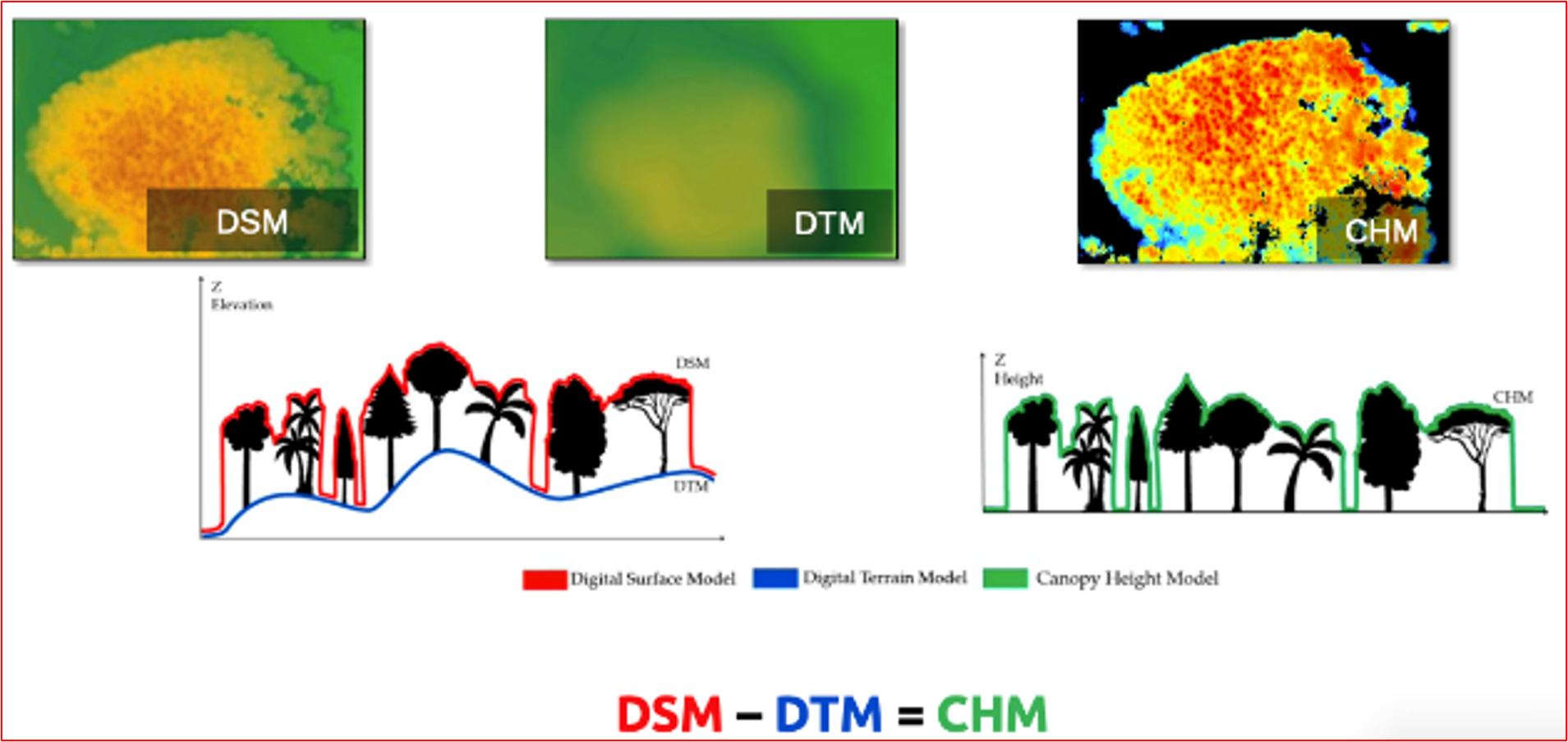
- Development of Digital Surface Model (DSM) & Orthomosaic generation (desktop work)
- Data analysis and refinement (desktop work)
- Integration into the prevailing data system (desktop work)
Drone data aids in evaluating indicators linked to carbon/biomass, such as mortality rates and forest types. Notably, with the application of allometric equations and proper characterization of the land type, above-ground biomass estimations of trees can be determined.
Enabling factors
Drones with pre-set flight planning capability ensure seamless orthophoto creation from individual images. This enables individual snapshots to seamlessly merge into an orthophoto (aerial photograph corrected for distortions, allowing accurate measurements). It's also vital to consider the availability of these drones in the local markets of partner countries. Leveraging local knowledge by involving local academia is paramount in this process. They can provide essential allometric equations, grounded in tree height, that facilitate precise biomass calculations.
Lesson learned
Drones generate high resolution images, allowing a detailed overview of land cover changes, tree survival and erosion rates, among others. Combined with field data, drone-based monitoring is strengthened, guaranteeing a sound monitoring.
The heterogeneity of trees and vegetation density often hinders a sound extraction of common key points between the images, which is necessary to estimate the heights and other indicators. In this regard, increasing the overlap between images to a minimum of 85 % frontal and side overlap can improve the extraction of key points. Also, increasing the flight height of the drone reduces perspective distortion, which facilitates the detection of visual similarities between overlapping images. However, too much overlapping, i.e., high overlapping percentages result in higher amount of data, making data processing more time intensive.
Another aspect already mentioned is the availability of suitable drones in the partner countries. Importing drones to the respective countries is difficult, and bureaucratic barriers persist.
Impacts
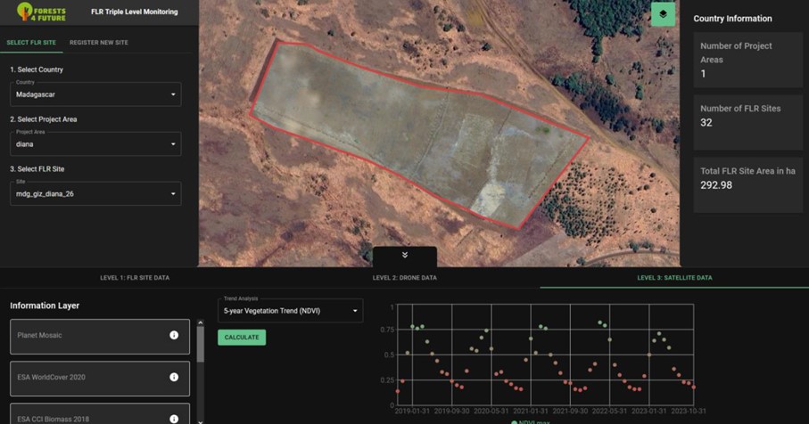
All three data sources (satellite, drone, and field) are processed and integrated onto a dashboard platform, accessible through the projects monitoring website. The website enables:
Internally:
· The evaluation of the project activities
· The monitoring of changes as basis for further planning
· The management of project activities (steering function)
· Reporting on project activities
· Comparing and summarizing FLR interventions
Externally:
· Tracking of project activities
· Harmonization of activities between projects and partners
· Learning from project experiences
· Reporting and communication of results
· Transparency of FLR activities
The platform dashboard has two unique attributes:
1. Area-specific: immediate automated analysis and visualization of satellite data of the past 5 years
2. Integration of field, drone and satellite data, combining a different layers of information to paint a holistic picture of the restoration efforts
Beneficiaries
- AFR100 Focal Points and Secretariat
- Ministries (Ministry of Forest/Environment and Agriculture)
- Administrative officers
- NGOs
- Restoration technicians and enthusiasts
- Local communities
- Team of the Forests4Future project, and other FLR projects
Sustainable Development Goals
SDG 15 – Life on land
SDG 17 – Partnerships for the goals
Story
Maxim leads the implementation of the 3LDM system in Madagascar. Using drones to assess Forest Landscape Restoration in Madagascar means also monitoring mangroves. Traditional monitoring in these dense, marshy terrains is daunting, but with 3LDM's drone protocol high-resolution imagery, it became more efficient and detailed.
During one drone survey, Maxim’s team discovered an unexpected resident: a sunbathing crocodile. The crisp imagery not only highlighted the effectiveness of the technology but underscored its safety advantage over on-foot surveys.
Beyond unexpected wildlife encounters, 3LDM offered insights into the mangroves' growth dynamics. While the system had its challenges, like drones adapting to the windy conditions, the outcomes outweighed the hurdles.