Gestión ecosistémica de las inundaciones y sequías en las cuencas fluviales
Solución completa
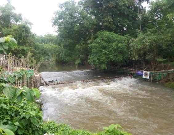
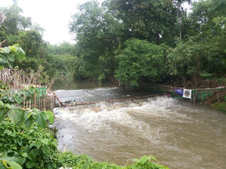
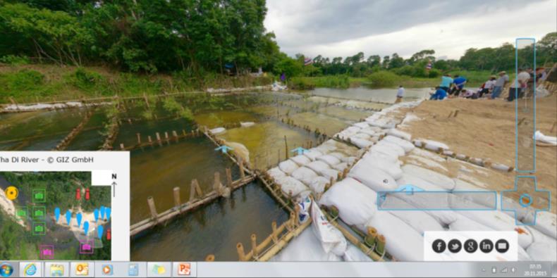
Construcción de una presa viva en Nakhon Si Tammarat con revegetación de las riberas y estructuras de bambú
GIZ Thailand, 2015
Se aplican medidas técnicas y de desarrollo de capacidades en las cuencas hidrográficas amenazadas por el cambio climático. Se apoya a los profesionales pertinentes en las evaluaciones de vulnerabilidad. Se garantiza la inclusión de la población mediante la participación en plataformas de partes interesadas. Los enfoques EbA innovadores, como el enfoque de "presa viva", se basan en los conocimientos y las iniciativas locales y se aplican con fines de demostración. Se utilizaron métodos técnicos innovadores, como los drones, para evaluar y supervisar la zona del proyecto antes, durante y después de las actividades. Este enfoque recibió recientemente el premio International Drone Pioneer Award 2017 a las aplicaciones visionarias de drones con impacto global. A partir de las experiencias, los enfoques de AbE se introducen en el ámbito nacional y en el formato educativo.
Última actualización: 01 Oct 2020
162923 Vistas
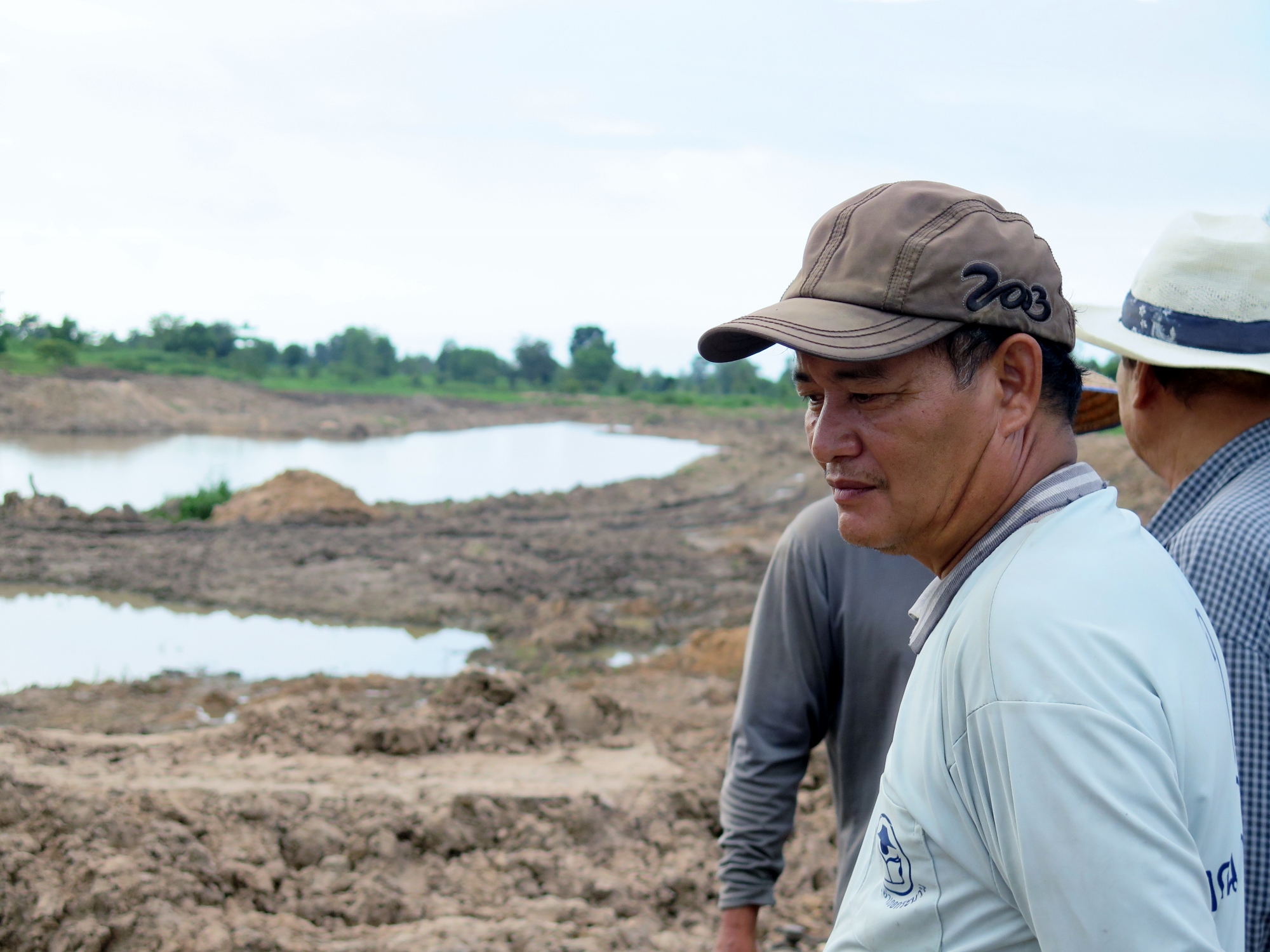
Galería de fotos y vídeos

Contexto
Défis à relever
- El aumento de las inundaciones y las sequías causa daños y escasez de agua.
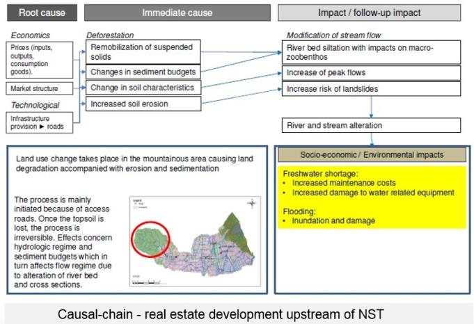
- Las actividades de uso del suelo en las cuencas fluviales (arroz, caucho, caña de azúcar) favorecen la degradación del suelo causando la erosión del suelo y de las riberas fluviales, la sedimentación de las infraestructuras grises, el aumento del riesgo de corrimientos de tierras, la pérdida de biodiversidad y de capacidad de retención de agua.
- Las instituciones locales de gestión del agua carecen de capacidad técnica y de conceptos para hacer frente a estos fenómenos extremos.
- La población se enfrenta a pérdidas económicas por la pérdida de cosechas y de producción en el sector pesquero. Carecen de disponibilidad de agua durante la estación seca y se enfrentan a daños en sus hogares y campos en la estación lluviosa.
- Los conflictos políticos entre los distintos sectores y la ausencia de normas formales para la planificación urbana agravan los problemas.
Ubicación
Provincia de Khon Kaen de Khon Kaen Tailandia
Sudeste Asiático
Procesar
Resumen del proceso
La evaluación de las vulnerabilidades y la identificación de diferentes medidas AbE para abordarlas (componente 1) es una condición previa para aplicar la medida AbE más viable, por ejemplo, presas vivas (componente 2). Esta medida utiliza los conocimientos locales (building block 3) en combinación con los enfoques de adaptación más avanzados. El intercambio de conocimientos entre los responsables de la toma de decisiones y los profesionales (componente 4), junto con el desarrollo de capacidades en materia de seguimiento de los recursos hídricos, modelización y métodos de valoración económica (componente 5), permite seguir ampliando el enfoque.
Bloques de construcción
Análisis de vulnerabilidad e identificación de medidas EbA
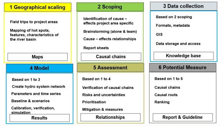
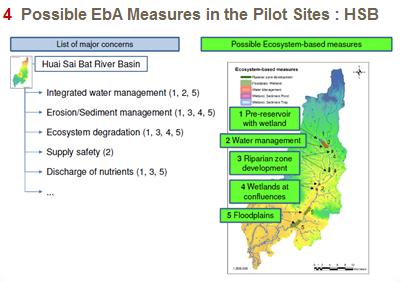
El enfoque de evaluación de la vulnerabilidad permite detectar los mayores problemas en las cuencas hidrográficas. Para esta evaluación, el planteamiento se basó en la metodología GIWA (Global International Water Assessment Methodology) y HSAP (Hydropower Sustainability Assessment Protocol) y sigue un enfoque de 6 pasos que incluye los siguientes: 1) delimitación geográfica (cartografía de los puntos conflictivos): se definen los límites geográficos de las zonas piloto que se van a analizar; se identifican las subregiones dentro de cada zona del proyecto y se cartografían las principales características del sistema hidroeléctrico y las actividades económicas; 2) determinación del alcance: se evalúan las repercusiones medioambientales y socioeconómicas y se establecen las prioridades entre las principales preocupaciones y problemas, así como los factores causantes de las preocupaciones y problemas seleccionados; 3) recopilación de datos; 4) modelización para verificar y cuantificar las relaciones entre las causas profundas con modelos físicos deterministas o conceptuales que abarquen a) modelización hidrológica con el programa TalsimNG, b) modelización de la erosión y la sedimentación con la Ecuación Uniforme Modificada de Pérdida de Suelo (MUSLE), c) modelización de la calidad del agua con el programa GISMO; 5) evaluación para identificar riesgos e incertidumbres y priorizar vulnerabilidades; 6) identificación y clasificación de posibles medidas de AbE.
Factores facilitadores
Conjuntos de datos disponibles (por ejemplo, SIG) sobre modelos digitales de elevación y series temporales de descarga de agua, precipitaciones, temperatura, humedad y evapotranspiración. Cooperación de las partes interesadas locales para garantizar que forman parte de los procesos de toma de decisiones y que se abordan sus problemas prioritarios.
Lección aprendida
- Los distintos datos, descarga, evaporación, humedad, temperatura, etc., son propiedad de diferentes instituciones. Algunas de ellas no comparten sus datos por considerarlo una pérdida de poder. Esto debe tenerse en cuenta lo antes posible. El proyecto utilizó drones para recoger datos adicionales sobre el caudal del río. - Los conjuntos de datos estaban en parte incompletos. La información que falta no permite analizar y cuantificar determinados efectos, por lo que los resultados de las evaluaciones siguen incluyendo incertidumbres.
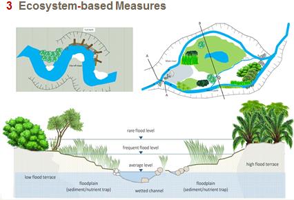
Medida EbA: Presas vivas como amortiguadores de inundaciones

El concepto de vertedero viviente es una medida EbA basada en los conocimientos de las comunidades locales de la cuenca fluvial y en consonancia con la filosofía de economía de suficiencia del Rey de Tailandia de aplicar tecnologías basadas en los recursos y conocimientos locales. En una primera fase se construye una rejilla de bambú en el río que sirve de estructura para los sacos de arena degradables que contienen una mezcla de arena, coco y estiércol. A lo largo de las orillas del río se planta una combinación de árboles banyan (Ficus bengalensis) y otras plantas leguminosas para estabilizar los suelos. Las raíces que forman se nutrirán del estiércol y penetrarán en la construcción de bambú en las próximas décadas para formar una "presa viva". Esta tecnología conlleva varios beneficios, como la mejora de la recarga de las aguas subterráneas, que puede aumentar el rendimiento de los cultivos, el incremento de la biodiversidad, como el aumento del hábitat de los peces, la variedad de plantas, etc., y el fortalecimiento de la unidad entre las partes interesadas. Las terrazas también permiten a los peces desplazarse río arriba. Los costes y esfuerzos de mantenimiento de esta metodología son bajos y las comunidades locales pueden llevarlos a cabo fácilmente.
Factores facilitadores
- Aceptación y propiedad locales - claridad en la tenencia de la tierra en el lugar de construcción - participación de las partes interesadas, como la población local, (idealmente con el apoyo del gobierno y el sector privado) - materiales naturales disponibles en la zona, como bambú, sacos de arena, plantones de árboles, etc. - trabajo voluntario, apoyo presupuestario y material de la comunidad en la primera fase, apoyo del gobierno y/o del sector privado en una fase posterior.
Lección aprendida
- Al considerarse una sabiduría local, estas medidas cuentan con el pleno apoyo de la comunidad local y son financiadas y aplicadas por los interesados locales. Esto les ha granjeado mucha atención e interés por parte de las instituciones gubernamentales tailandesas. - Sin embargo, carecen de respaldo científico. Esto hace que se construyan sin una planificación adecuada y sin coordinación con las instituciones locales de gestión del agua. En el pasado, las presas de nueva construcción se construyeron en lugares y momentos equivocados, subestimando el caudal del río durante las primeras crecidas, lo que causó daños o incluso la destrucción de las estructuras incompletas - La concienciación sobre los impactos físicos y socioeconómicos del cambio climático ha aumentado la aceptación de las medidas EbA por parte de los interesados locales. Sin embargo, se necesitan más conocimientos para borrar la creencia sobre los falsos efectos de las medidas EbA y para transmitir a las partes interesadas en qué lugares son viables las medidas EbA.
Utilización de los conocimientos locales y apropiación a través de los comités de cuenca fluvial
La creación de comités de cuenca que representen a la población de una cuenca fluvial, así como al mundo académico, el gobierno y otros sectores, es crucial para el éxito de la gestión de los ríos. La conexión entre la población local y los recursos hídricos, especialmente en la cuenca del río Tha Di, es muy fuerte. En las comunidades locales, los conocimientos sobre los cambios climáticos y las catástrofes naturales (inundaciones y sequías) se han transmitido de generación en generación sin mucha documentación escrita. El concepto de protección contra inundaciones mediante presas vivas surgió de las comunidades ribereñas locales y de líderes fuertes con ideas innovadoras y la voluntad de experimentar diferentes enfoques para la protección contra inundaciones y sequías. La combinación de esta fuerte apropiación con los datos hidrológicos de las universidades locales y la capacidad administrativa de las instituciones de gobierno regionales permite un enfoque holístico de la gestión del agua. Todos estos actores están representados en los comités de cuenca.
Factores facilitadores
- ideas innovadoras y voluntad de experimentar - voluntad de contribuir con recursos (tiempo, mano de obra, material local) - los comités de cuenca son el puente entre las partes interesadas locales y las instituciones gubernamentales encargadas de la gestión del agua
Lección aprendida
Los comités de cuenca fluvial (CCF) de las distintas cuencas se encontraban en fases muy diferentes al inicio del proyecto. Algunos estaban plenamente establecidos, lo que facilitaba la comunicación con la población local y la cooperación entre las partes interesadas locales, el sector público y el mundo académico. Otras no habían celebrado su primera reunión cuando comenzó el proyecto. En este caso, las partes interesadas locales se apropiaron en gran medida de sus recursos hídricos, lo que permitió que el proyecto avanzara mientras la CTF aún estaba en proceso de creación.
Visitas de intercambio de conocimientos a escala local y nacional
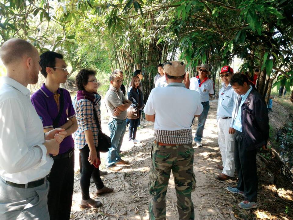
La organización de visitas sobre el terreno y el intercambio de partes interesadas y responsables de la toma de decisiones entre las tres cuencas fluviales piloto fue un método excelente para fomentar el intercambio y el aprendizaje mutuo sobre posibles medidas de AbE entre cuencas fluviales e instituciones. Este intercambio dio lugar a un importante intercambio sobre la viabilidad de las medidas, su aplicación en diferentes lugares y las posibilidades de ampliación. Además, por un lado, se pudo percibir un amistoso espíritu competitivo en cuanto a qué cuenca fluvial tendría antes la mejor gestión del agua basada en los ecosistemas. Por otro lado, instituciones que compiten entre sí se unieron y empezaron a cooperar.
Factores facilitadores
- Intercambio de lecciones aprendidas a nivel local - Cooperación entre cuencas hidrográficas - El proyecto de la GIZ, como marco neutral, permitió reunir a instituciones no cooperativas
Lección aprendida
- Los ejemplos tangibles y las buenas prácticas sobre medidas de AbE ayudan a las partes interesadas a comprender mejor los conceptos de AbE y sus beneficios. - Al mismo tiempo, las medidas de AbE no pueden copiarse sin más a otras cuencas hidrográficas y es preciso concienciar a las personas pertinentes de la necesidad de realizar evaluaciones de la vulnerabilidad específicas para cada cuenca hidrográfica.
Creación de capacidades técnicas en materia de seguimiento de los recursos hídricos, modelización y métodos de valoración económica
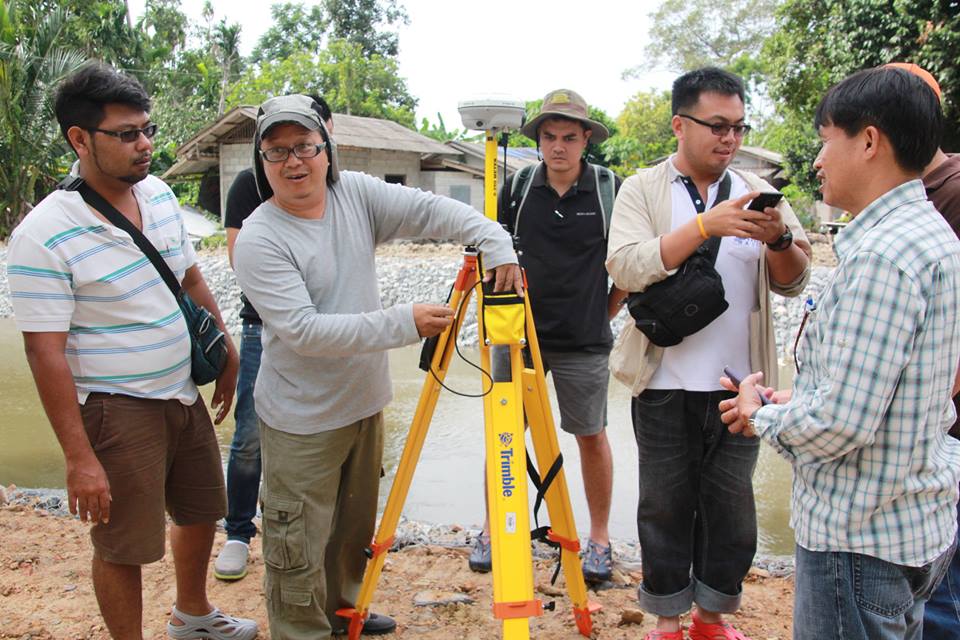
A nivel local y nacional se crearon capacidades clave para establecer una gestión fluvial sostenible, como la modelización hidrológica, la evaluación de la vulnerabilidad ante futuras inundaciones y sequías y métodos de valoración económica para identificar medidas de adaptación adecuadas basadas en los ecosistemas. El proyecto introdujo la tecnología de los drones para vigilar la cuenca y mejorar la modelización de futuros riesgos de inundación. Se impartió una serie de cursos de formación, desarrollados conjuntamente con institutos de investigación y profesionales alemanes, que contenían tanto fundamentos teóricos como aplicaciones prácticas en las cuencas fluviales.
Factores facilitadores
- Motivación de personas individuales que actúen como agentes del cambio dentro de su propia institución y realicen un seguimiento de las formaciones o apliquen los nuevos conocimientos adquiridos en su trabajo diario.
Lección aprendida
Las instituciones y los expertos internacionales deben conocer la gestión del conocimiento y las estructuras de aprendizaje de las instituciones locales y estar dispuestos a adaptar su propio enfoque en consecuencia.
Impactos
1) Medio ambiente
- Se reducen los daños causados por inundaciones y sequías a las comunidades locales, la economía y la ecología.
- Los sedimentos y nutrientes se mantienen en las zonas de interés agrícola.
- Mejora la calidad del agua.
- Los hábitats descentralizados y nuevos funcionan como valiosas zonas de conservación de la biodiversidad, especialmente durante la estación seca.
2) Social
- Las comunidades son más resistentes a las inundaciones repentinas durante la estación de lluvias.
- El agua de las inundaciones, que queda retenida en el paisaje, aumenta el almacenamiento de agua para el consumo y el riego durante la estación seca.
- Se puede suministrar más agua a más personas y/o para más tierras de regadío.
- entre 780 personas más en el año y hasta 15.000 personas más en el año 25.
- Se ha llegado a 1.500 personas directamente y a 4.500 indirectamente gracias a la sensibilización y la formación, 530 funcionarios han recibido formación en evaluación económica de las opciones de EbA.
3) Políticas
- DWR y RID, como principales organizaciones responsables de la guerra, están dando prioridad a las soluciones EbA en sus políticas y planes, con una inversión de 535.000 EUR por parte de DWR y de 20 millones EUR por parte de RID.
- El actual gobierno, el Consejo Nacional de Paz y Orden, ha anunciado proyectos de rehabilitación forestal (unas 7.520 ha) y de prevención de la erosión del suelo (se plantará hierba vetiver en 1.080 km2).
- La rehabilitación forestal y la plantación de hierba vetiver absorberán hasta 84.000 toneladas de CO2 al año.
Beneficiarios
La población rural de las cuencas fluviales se beneficia de la aplicación de medidas de gestión de inundaciones y sequías gracias a la reducción de la vulnerabilidad frente a los impactos de las inundaciones y sequías.
Objetivos de Desarrollo Sostenible
ODS 6 - Agua limpia y saneamiento
ODS 13 - Acción por el clima
ODS 15 - Vida de ecosistemas terrestres
Historia

Agricultor Wanchart Samdang
GIZ Thailand, 2015
El agricultor Wanchart Samdang, de Nakhon Si Thammarat, como la mayoría de los agricultores del sur de Tailandia, cultiva poco arroz, pero está especializado en hortalizas y frutas, sobre todo durian y mangostán. Ambas se venden bien en los mercados locales. Sin embargo, el riego es un problema y, al final de la estación seca, el agua escasea. Su embalse se llena durante la temporada de lluvias y el agua riega los árboles frutales. Durante la estación seca tiene que aprovechar el agua del río, bombeándola a los huertos frutales. Como la disponibilidad de agua es un problema común en esta zona, los agricultores de los pueblos adyacentes han unido sus fuerzas. Con la ayuda del gobierno y el apoyo de las universidades locales y la GIZ, están construyendo una presa viva que frena la crecida del río. Antes habían intentado construirlo con cemento, pero éste es un material "muerto" que el agua destruye y cuya construcción y mantenimiento resultan caros. Por eso los agricultores han utilizado bambú y otros materiales naturales en combinación con vegetación fluvial como árboles y arbustos, estabilizando la ribera. Han creado un "dique viviente" que resiste las crecidas y frena el curso del río, de modo que el agua fluye más hacia la naturaleza circundante. La comunidad local se ve fortalecida por el trabajo conjunto. Todos participan y la escasez de agua rara vez es un problema. Además, el rendimiento de los árboles frutales ha aumentado, lo que permite al Sr. Samdang ganar más dinero con un método de riego sostenible.
Conectar con los colaboradores
Otros colaboradores
Sr. Suthira Thongkao (Profesor, proveedor de soluciones)
Universidad Walailak
Sr. Roland Treitler (Director de proyecto, proveedor de soluciones)
Deutsche Gesellschaft für Internationale Zusammenarbeit (GIZ) GmbH (Sociedad Alemana de Cooperaci...
Sra. Jaruwan Ngamsing (Responsable de proyecto, proveedor de soluciones)
Deutsche Gesellschaft für Internationale Zusammenarbeit (GIZ) GmbH (Sociedad Alemana de Cooperaci...
Sr. Mathias Bertram (Asesor de EbA, autor)
Deutsche Gesellschaft für Internationale Zusammenarbeit (GIZ) GmbH (Sociedad Alemana de Cooperaci...