Supervisión digital de triple nivel (3LDM) - Soluciones de teledetección e informática para supervisar la restauración del paisaje forestal (FLR)
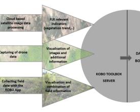
El proyecto Forests4Future (F4F) de la GIZ promueve la restauración del paisaje forestal y la gobernanza en países como Etiopía, Madagascar y Togo. Los actuales sistemas de seguimiento de la FLR se enfrentan a problemas de precisión y exhaustividad. Para solucionarlo, F4F inició el desarrollo de un sistema de seguimiento fiable y el pilotaje de un procedimiento operativo estándar. Aprovechando la experiencia de empresas externas de datos geoespaciales, F4F introdujo el Sistema de Seguimiento Digital de Triple Nivel (3LDM). Este sistema perfecciona la supervisión, integrando tres niveles de datos:
1. Datos de campo
2. Datos de drones
3. Datos por satélite
El enfoque 3LDM realiza un seguimiento de las hectáreas restauradas, la biomasa arbórea sobre el suelo y la diversidad arbórea en las zonas de RPF seleccionadas.
Contexto
Défis à relever
Desafíos medioambientales:
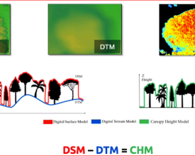
Las imágenes obtenidas por satélite, como Sentinel o Landsat, pueden pasar por alto árboles más pequeños debido a su baja resolución, lo que afecta a la evaluación precisa de los bosques, especialmente de los de crecimiento joven o bajo dosel. El sistema 3LDM, que utiliza datos de alta resolución obtenidos por drones, mide la altura de las copas y, mediante ecuaciones alométricas, afina los cálculos de biomasa. Los drones, al inspeccionar zonas extensas, mejoran la precisión y la eficacia de los datos.
Retos sociales:
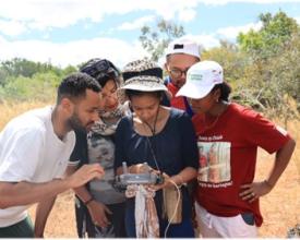
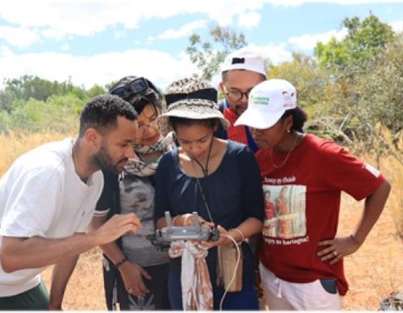
La vigilancia forestal tradicional exige trabajo manual, lo que supone trastornos para las comunidades locales. 3LDM, que aprovecha la tecnología de los drones y los satélites, vigila amplias zonas con una intrusión mínima, preservando las costumbres locales. Además, fomenta el desarrollo de habilidades locales relacionadas con los drones y las oportunidades de empleo.
Retos económicos:
El inventario forestal manual es costoso y lento. 3LDM ofrece una solución económica. La recogida de datos con drones, al ser más rápida y expansiva, reduce los costes del trabajo de campo. El uso de imágenes de código abierto reduce los gastos, lo que hace que el seguimiento sea asequible y adaptable a diversos proyectos.
Ubicación
Procesar
Resumen del proceso
La intrincada sinergia de los tres mecanismos de recopilación de datos -datos de campo, imágenes de drones y capturas por satélite- constituye la espina dorsal del marco de seguimiento de nuestro programa. Cada mecanismo aporta una fuerza única: mientras que los datos de campo ofrecen una visión granular a nivel del suelo, las imágenes de drones proporcionan una perspectiva aérea detallada, y las capturas por satélite ofrecen una visión más amplia desde el espacio. Cuando se entrelazan, crean un sólido tapiz de datos que refuerza su fiabilidad y precisión.
Este enfoque sinérgico es fundamental para la supervisión holística de las estrategias de FLR. Ante la creciente complejidad de los esfuerzos de restauración medioambiental, es imprescindible tener una visión polifacética. Seguimiento de indicadores clave como la biomasa. Además, los indicadores secundarios como la altura de los árboles, el diámetro a la altura del pecho (DAP), la composición del bosque y la diferenciación de especies son fundamentales para una comprensión matizada de los esfuerzos de restauración. Lo mejor del sistema de tres niveles es su capacidad de recuperación: si surgen problemas que limitan la eficacia de un método, los otros dos intervienen sin problemas, garantizando que no se pierda la calidad de los datos ni la perspectiva. Esta interdependencia garantiza la exhaustividad de los datos, lo que se traduce en estrategias mejor fundamentadas y resultados satisfactorios en materia de FLR.
Bloques de construcción
Datos de campo
Las imágenes de satélite y de drones, a pesar de su innegable contribución al seguimiento, son limitadas en los primeros años de los esfuerzos de FLR. La recopilación de datos sobre el terreno es crucial en los primeros años de los proyectos.
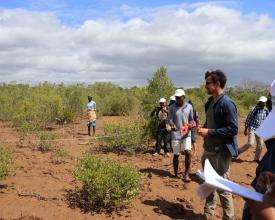
La recopilación de datos sobre el terreno se divide a su vez en tres enfoques participativos:
- Parcelas permanentes de muestreo: Parcelas fijas, en las que se estimará la altura de los árboles, el DAP y las tasas de supervivencia de los árboles. Las parcelas permanentes de muestreo se evaluarán en intervalos de 3 años, debido a su elevado coste en mano de obra y tiempo.
- Ordenación del territorio: Rondas de discusión para la evaluación de la información, así como identificación de especies amenazadas según la Lista Roja de Especies Amenazadas de la Unión Mundial para la Naturaleza (UICN). Se integra en otros procesos de planificación del uso de la tierra, por lo que no tiene un intervalo de evaluación definido.
- Transectos: Identificación de especies florísticas y faunísticas, así como de la composición de la estructura forestal, en un intervalo de evaluación de tres meses.
Todos los indicadores relevantes incluidos en los tres enfoques participativos se recogen utilizando la caja de herramientas KOBO. Este software ofrece condiciones adecuadas y es fácil de manejar, alineándose con los objetivos de seguimiento del proyecto.
Factores facilitadores
Un enfoque participativo es esencial para garantizar un seguimiento a largo plazo de las zonas restauradas. La simbiosis de los conocimientos locales y la formación y capacitación del personal local y los socios regionales es el núcleo de este enfoque. Identificar las necesidades de la comunidad, organizar rondas de debate, implicar a la comunidad local en el desarrollo y la puesta a prueba del sistema de seguimiento, fomenta la concienciación y la conexión con el paisaje restaurado.
Lección aprendida
-
Prioridad a los datos de campo: En las primeras etapas de la FLR, la recopilación de datos sobre el terreno es más eficaz que basarse únicamente en imágenes satelitales y de drones.
-
Enfoques participativos: El empleo de métodos participativos como parcelas permanentes de muestreo, planificación del uso de la tierra y transectos implica a las comunidades locales y mejora el seguimiento.
-
Tecnología adecuada: El uso de herramientas fáciles de usar como KOBO Toolbox se alinea bien con los objetivos del proyecto y simplifica la recopilación de datos.
-
Participación de la comunidad local: Involucrar y formar a las comunidades locales garantiza el éxito a largo plazo y fomenta la conexión con los paisajes restaurados.
Datos por satélite
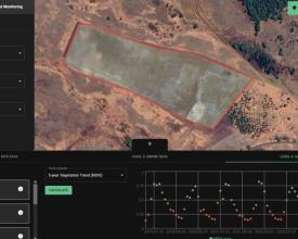
Los datos de satélite constituyen la base del sistema de vigilancia 3LD, que aprovecha las capacidades de las imágenes de código abierto de los satélites Copernicus Sentinel-2 y LANDSAT. Un algoritmo, meticulosamente desarrollado por Remote Sensing Solutions (RSS) GmbH, revoluciona este proceso. Los usuarios pueden enviar sin problemas el shapefile de su área de interés, lo que hace que el algoritmo busque y analice automáticamente los datos pertinentes. Se lleva a cabo un amplio abanico de sólidos análisis, como la tendencia de la vegetación a 5 años mediante NDVI para evaluar las ganancias o pérdidas de vegetación, el análisis de la humedad de la vegetación a 5 años mediante NDWI y una evaluación matizada de la tendencia de las precipitaciones a 5 años. Además, el algoritmo facilita la visualización de los cambios en la vegetación desde el inicio del proyecto, reforzando el marco de seguimiento con una visión dinámica. Los datos de satélite, un componente vital del sistema de vigilancia 3LDM, aprovechan las imágenes de código abierto de la misión Sentinel-2 de Copernicus y de los satélites LANDSAT. Para zonas predefinidas, estos datos se obtienen automáticamente y se analizan en función de parámetros específicos. Los análisis clave incluyen una tendencia de la vegetación a 5 años utilizando el NDVI como indicador de las ganancias o pérdidas de vegetación, una tendencia de la humedad de la vegetación a 5 años mediante el NDWI y una tendencia de las precipitaciones a 5 años. Además, pueden visualizarse los cambios en la vegetación desde el inicio del proyecto.
Factores facilitadores
El uso eficaz de este bloque depende de que los usuarios dibujen y guarden las áreas en plataformas SIG como QGIS. Además, la mejora del shapefile con datos específicos del proyecto, como las fechas de inicio y el tipo de FLR, optimiza el análisis. Una formación adecuada en estas habilidades garantiza la introducción de datos precisos y un seguimiento adaptado, por lo que el desarrollo de capacidades en estas áreas es esencial si no existe.
Lección aprendida
Aunque los datos de satélite, especialmente los de libre acceso, ofrecen una amplia perspectiva, su capacidad para la identificación de especies es muy restringida, cuando no inalcanzable. Esta limitación pone de relieve el papel indispensable del trabajo de campo para discernir la composición y las características de las especies. Además, la comprensión de las limitaciones innatas de las imágenes por satélite, especialmente con plantaciones de árboles jóvenes, refuerza la necesidad de integrar datos de campo y de drones para obtener una visión completa de los terrenos forestales.
Datos de drones
Los drones desempeñan un papel fundamental en el sistema de vigilancia del 3LD, como complemento de otros métodos de recogida de datos. Estos conocimientos abarcan la planificación del vuelo, la navegación y la evaluación de imágenes. El seguimiento con drones pretende capacitar al personal del proyecto para capturar datos adaptados a los análisis fotogramétricos, de los que surge una geoinformación crucial.
La metodología de cartografía con drones comprende cinco etapas, de las cuales las dos primeras se centran en las operaciones con drones:
- Preparación de la misión cartográfica (trabajo de escritorio)
- Ejecución de la misión cartográfica (trabajo de campo)
- Desarrollo del modelo digital de superficie (MDS) y generación del ortomosaico (trabajo de escritorio)
- Análisis y perfeccionamiento de datos (trabajo de escritorio)
- Integración en el sistema de datos vigente (trabajo de escritorio)
Los datos de los drones ayudan a evaluar los indicadores vinculados al carbono/biomasa, como las tasas de mortalidad y los tipos de bosque. En particular, con la aplicación de ecuaciones alométricas y una caracterización adecuada del tipo de terreno, se pueden determinar estimaciones de la biomasa por encima del suelo de los árboles.
Factores facilitadores
Los drones con capacidad de planificación de vuelo preestablecida garantizan la creación perfecta de ortofotos a partir de imágenes individuales. De este modo, las instantáneas individuales se fusionan a la perfección en una ortofoto (fotografía aérea corregida de distorsiones que permite mediciones precisas). También es fundamental tener en cuenta la disponibilidad de estos drones en los mercados locales de los países socios. Aprovechar los conocimientos locales implicando al mundo académico local es primordial en este proceso. Pueden proporcionar ecuaciones alométricas esenciales, basadas en la altura de los árboles, que faciliten cálculos precisos de la biomasa.
Lección aprendida
Los drones generan imágenes de alta resolución que permiten obtener una visión detallada de los cambios en la cubierta terrestre, la supervivencia de los árboles y los índices de erosión, entre otros. Combinado con datos de campo, el seguimiento con drones se refuerza, garantizando una vigilancia sólida.
La heterogeneidad de los árboles y de la densidad de la vegetación dificulta a menudo una extracción sólida de puntos clave comunes entre las imágenes, lo que es necesario para estimar las alturas y otros indicadores. En este sentido, aumentar el solapamiento entre imágenes hasta un mínimo del 85 % de solapamiento frontal y lateral puede mejorar la extracción de puntos clave. Asimismo, aumentar la altura de vuelo del dron reduce la distorsión de la perspectiva, lo que facilita la detección de similitudes visuales entre imágenes solapadas. Sin embargo, un solapamiento excesivo, es decir, porcentajes de solapamiento elevados, da lugar a una mayor cantidad de datos, lo que hace que su procesamiento requiera más tiempo.
Otro aspecto ya mencionado es la disponibilidad de drones adecuados en los países socios. La importación de drones a los respectivos países es difícil y persisten las barreras burocráticas.
Impactos
Las tres fuentes de datos (satélite, dron y campo) se procesan e integran en una plataforma de control, accesible a través del sitio web de seguimiento del proyecto. El sitio web permite:
A nivel interno:
- La evaluación de las actividades del proyecto
- El seguimiento de los cambios como base para la planificación posterior
- La gestión de las actividades del proyecto (función directiva)
- La elaboración de informes sobre las actividades del proyecto
- Comparación y resumen de las intervenciones de la FLR
Externamente:
- Seguimiento de las actividades de los proyectos
- Armonización de actividades entre proyectos y socios
- Aprendizaje de las experiencias de los proyectos
- Presentación de informes y comunicación de resultados
- Transparencia de las actividades de FLR
El salpicadero de la plataforma tiene dos atributos únicos:
1. Específico de la zona: análisis y visualización inmediatos y automatizados de los datos satelitales de los últimos 5 años.
2. Integración de datos de campo, de drones y de satélites, combinando diferentes capas de información para ofrecer una imagen holística de los esfuerzos de restauración.
Beneficiarios
- AFR100 Puntos Focales y Secretaría
- Ministerios (Ministerio de Bosques/Medio Ambiente y Agricultura)
- Funcionarios administrativos
- ONG
- Técnicos y aficionados a la restauración
- Comunidades locales
- Equipo del proyecto Forests4Future y otros proyectos de FLR
Objetivos de Desarrollo Sostenible
Historia
Maxim dirige la implantación del sistema 3LDM en Madagascar. Utilizar drones para evaluar la restauración del paisaje forestal en Madagascar significa también supervisar los manglares. El seguimiento tradicional en estos terrenos densos y pantanosos es desalentador, pero con las imágenes de alta resolución del protocolo de drones de 3LDM, se hizo más eficiente y detallado.
Durante una inspección con dron, el equipo de Maxim descubrió un residente inesperado: un cocodrilo tomando el sol. Las nítidas imágenes no sólo pusieron de manifiesto la eficacia de la tecnología, sino que subrayaron su ventaja en materia de seguridad frente a las prospecciones a pie.
Más allá de los encuentros inesperados con la fauna, 3LDM ofreció información sobre la dinámica de crecimiento de los manglares. Aunque el sistema tuvo sus dificultades, como la adaptación de los drones al viento, los resultados superaron los obstáculos.
