Approche interactive et transparente de la planification de l'espace marin
Solution complète


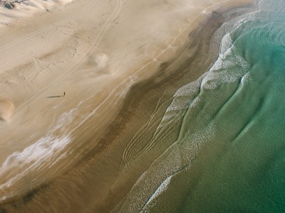
Le littoral israélien
Israel Bardugo
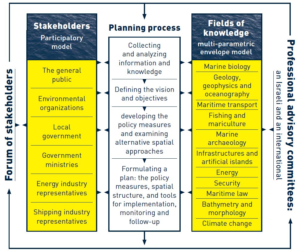
La solution porte sur la participation des parties prenantes à la planification et à la gestion de l'espace marin israélien. Une plateforme SIG interactive a été développée pour visualiser la distribution spatiale des différentes utilisations des ressources dans les eaux marines d'Israël afin de promouvoir la sensibilisation à l'environnement marin. Elle aborde également les questions de transparence et de diffusion des connaissances. Les parties prenantes sont activement impliquées dans le processus de planification et accompagnées par des comités consultatifs scientifiques locaux et internationaux.
Dernière modification 28 Mar 2019
6039 Vues
Galerie de photos et de vidéos


Contexte
Défis à relever
Manque d'informations marines consolidées ; difficulté à envisager des scénarios spatiaux - Manque de transparence concernant les données spatialement explicites - Interface avec le public, en particulier avec les parties prenantes qui n'ont pas participé aux réunions publiques - Manque d'informations marines consolidées et diversité des utilisations accessibles au public - Dépenses et temps consacrés à la préparation de cartes physiques sur papier, à leur modification au fil du temps et à leur visualisation à différentes échelles dans des délais raisonnables.
Emplacement
Israël
Asie de l'Ouest, Moyen-Orient
Traiter
Blocs de construction
Collecte d'informations actuelles, complètes et pertinentes
Il est essentiel de disposer d'informations de qualité, fiables, détaillées, précises et actuelles. Soit l'autorité ou l'organisme qui fournit les informations doit les rendre compatibles avec le SIG, soit la personne chargée de la mise en œuvre de la solution doit convertir divers types de données en données SIG.
Facteurs favorables
Les principales conditions requises sont : 1) le financement 2) le partage des données entre les autorités, pour la plupart gouvernementales
Leçon apprise
Malgré le développement considérable de la cartographie, de la collecte de données et de la recherche au cours des dernières décennies, les connaissances sur l'espace marin israélien en Méditerranée, et en particulier sur la mer profonde qui en constitue la majeure partie, sont encore très limitées. En outre, l'absence d'une politique nationale visant à promouvoir la recherche marine et la collecte de données, à fournir des fonds suffisants pour son développement et à la rendre accessible est préoccupante. L'espace marin présente encore une administration éclatée, une gouvernance limitée et manque cruellement d'outils législatifs appropriés.
Tous ces éléments sont détaillés en détail dans le rapport de l'étape 1 du plan marin israélien et constituent la base de la définition des objectifs du plan et de la formulation de mesures politiques pour les atteindre.
Ressources
Compatibilités dans l'environnement marin
Afin d'examiner la manière dont les différentes utilisations sont intégrées dans l'espace marin, deux matrices de compatibilité ont été élaborées pour guider les mesures politiques proposées et la structure spatiale de ce plan. Ces deux matrices analysent : 1. Compatibilité et conflit entre les différentes utilisations 2. La compatibilité et les conflits entre les différentes utilisations et les ressources naturelles, le patrimoine et les valeurs culturelles. Les deux matrices sont basées sur une liste des utilisations et des valeurs de l'espace marin, ainsi que sur un résumé des impacts environnementaux de chaque utilisation, de leur importance et de leur portée. Sur la base des informations recueillies, les relations ont été catégorisées, en croisant les différents usages et en fonction du degré de synergie possible ou souhaitable entre eux.
Facteurs favorables
Une base de données solide et complète
Leçon apprise
Le temps nécessaire à la cartographie des compatibilités est assez long. La cartographie des compatibilités nécessite beaucoup de temps et de ressources. Les ressources consistent notamment à trouver les bonnes personnes et les bonnes informations pour formuler des hypothèses fondées sur les impacts. Enfin, il y aura toujours des parties prenantes qui ne seront pas d'accord avec certaines informations présentées dans les matrices de compatibilité. Ces matrices doivent être présentées comme "provisoires" et susceptibles d'être révisées au fil du temps.
Ressources
Outil interactif de prise de décision basé sur le SIG
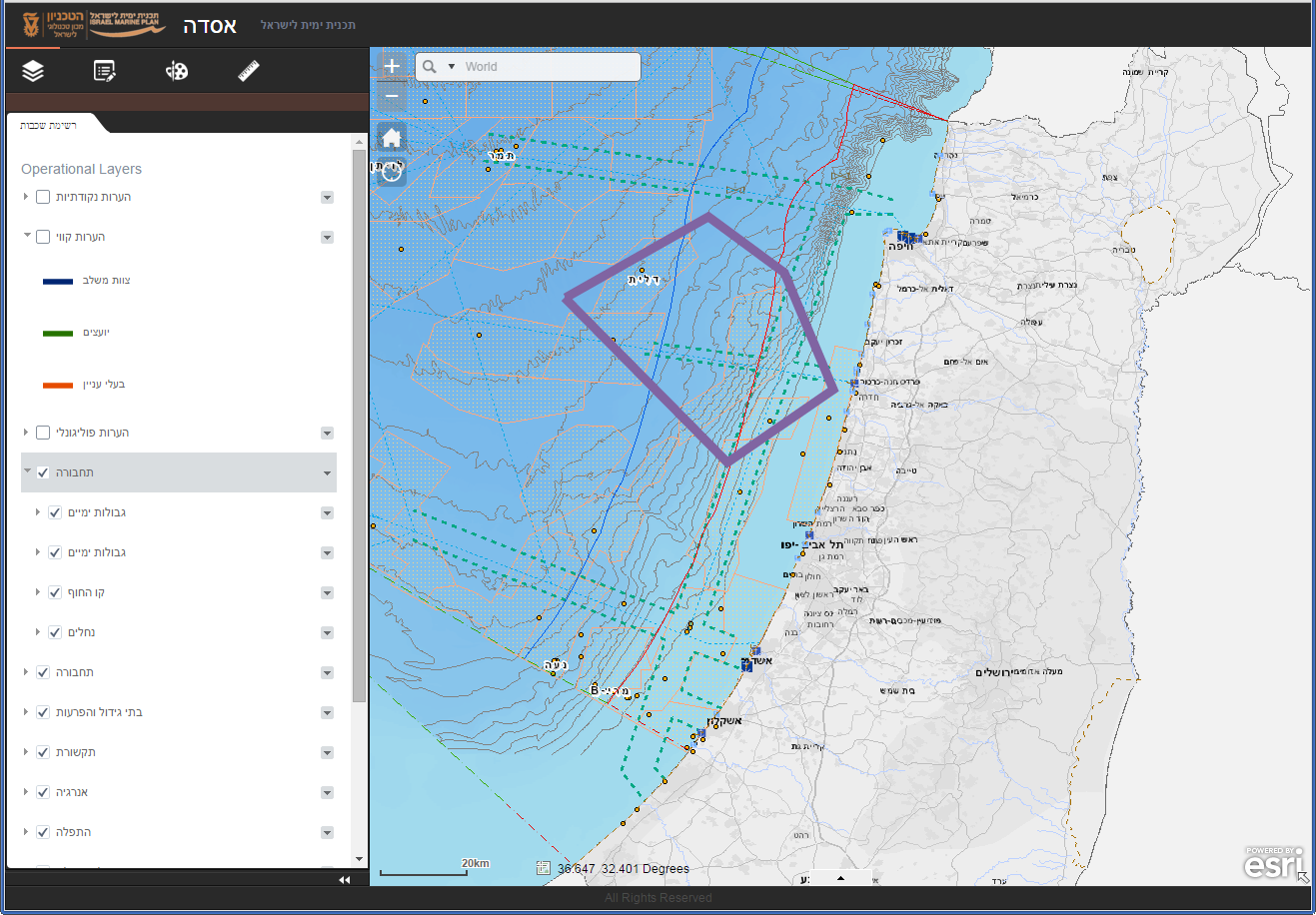
L'outil ASDA GIS (Asda = plateforme en hébreu) pour la planification de l'espace marin soutient les couches d'information existantes ainsi que les produits du processus de planification en cours d'une manière inclusive, flexible, visuelle, transparente et participative. Il permet aux experts et aux acteurs professionnels de différentes disciplines de croiser et d'analyser des données, de répondre et de participer de manière interactive, de dialoguer et d'échanger des idées et des opinions spatiales et textuelles relatives à la planification de l'espace marin. Cet outil est au service de tous les participants et présente les produits du plan à ses différentes étapes. Il apporte des solutions dans trois domaines d'activité : la planification, la participation et la gestion. La composante planification est destinée aux experts professionnels et aux conseillers de différentes disciplines, permettant un dialogue de groupe entre les experts et un échange flexible et visuel d'informations et d'idées concernant la planification de l'espace marin ; la composante participation est destinée au grand public et aux parties prenantes, permettant d'observer les produits du travail du plan d'espace marin et d'y réagir ; la composante gestion est destinée aux décideurs à différents niveaux, permettant des analyses spatiales et statistiques ainsi que des examens basés sur l'information des scénarios de développement.
Facteurs favorables
1) Financement 2) Capacité (personnel ayant des compétences en SIG et en programmation)
Leçon apprise
Le manque de volonté du personnel de planification de soutenir le développement d'un tel outil peut constituer un défi majeur. Lors de la planification de l'ASDA dans le cadre du plan Israël Maine, plusieurs planificateurs n'étaient pas d'accord. Ils préféraient utiliser des cartes sur papier et pensaient que l'outil en ligne serait une perte de temps. Parmi les membres de l'équipe de planification, les partisans représentaient environ 50 %. La présence d'un plus grand nombre de jeunes, de personnes maîtrisant l'internet et peut-être d'universitaires (intéressés par des solutions innovantes) au sein de l'équipe centrale pourrait contribuer à résoudre ce problème. Une autre activité qui aurait pu être utile à cet égard aurait été de contrôler l'utilisation de l'outil, afin de "prouver" son utilité. En fin de compte, cela n'a pas été fait de manière systématique ou approfondie. Il faut une certaine ouverture à ce type d'outil, surtout de la part de ceux qui ne sont pas familiarisés avec la technologie. Un soutien politique et technique est nécessaire non seulement pour le développement de l'outil mais aussi pour sa promotion et son utilisation à chaque occasion.
Ressources
Planification participative
L'approche fondamentale du plan marin israélien met l'accent sur le fait que l'espace marin est essentiellement (et finalement) public. Il aspire à considérer équitablement les différents intérêts de toutes les parties prenantes et à garantir la fourniture de ses services écosystémiques au fil du temps. Par ses objectifs, le plan offre la possibilité d'une gestion éclairée et responsable de la mer, en appliquant une approche écologique globale. Il vise à développer les connaissances marines, à améliorer la sensibilisation du public à ce qui existe dans l'espace marin et à façonner sa représentation spatiale. Les parties prenantes sont activement impliquées dans le processus de planification et accompagnées par des comités consultatifs scientifiques professionnels locaux et internationaux. Le processus de planification est soutenu par l'utilisation d'un outil SIG interactif qui aide à visualiser l'utilisation des ressources, les conflits potentiels et les scénarios de gestion, permettant ainsi une planification globale.
Facteurs favorables
1) Temps nécessaire pour présenter et utiliser l'outil 2) Enthousiasme des personnes impliquées 3) Relations publiques pour l'utilisation de l'outil (c'est-à-dire le mentionner à chaque occasion, etc.)
Leçon apprise
Le manque de soutien au sein du personnel de l'équipe centrale a été un problème. La diversité des membres de l'équipe doit être maintenue (c'est-à-dire l'origine, l'âge, l'expertise, etc.). Le temps est essentiel pour que les efforts ne soient pas précipités et que le professionnalisme soit maintenu, en particulier pour les matrices de compatibilité. Cette "solution" ne conviendra pas à toutes les situations ; elle dépend du niveau de financement, de l'utilisation de l'internet et des outils numériques au sein de la population générale. Après avoir commencé à développer l'outil, nous avons découvert que d'autres organisations/entités disposaient d'outils similaires. Nous aurions pu les utiliser pour éviter les redondances et améliorer les données de base. Il aurait été utile de lier les informations des matrices de compatibilité à l'outil ASDA afin de pouvoir voir la compatibilité et/ou le conflit trouvé pour chaque zone au fur et à mesure que des utilisations concurrentes sont sélectionnées. Le suivi de l'utilisation de l'outil aurait été très utile. Un taux d'utilisation élevé (et diversifié) permettrait de soutenir davantage le développement et la promotion de l'outil.
Impacts
Il existe dans cette zone un potentiel considérable de développement et de fourniture de divers services à la société et à l'économie israéliennes, mais aussi une menace sérieuse pour le délicat équilibre naturel/écologique de l'environnement marin. Si elle se concrétise, cette menace pourrait nuire aux écosystèmes marins et côtiers sensibles et aux services qu'ils fournissent. En l'absence d'un plan global pour l'espace marin et d'outils efficaces pour le mettre en œuvre, ces menaces pourraient causer des dommages irréversibles.
Le développement d'un outil SIG interactif en ligne soutient le processus de planification de l'espace marin d'Israël grâce à : - la visualisation de la distribution spatiale des caractéristiques biogéographiques dans les eaux marines d'Israël ; - la visualisation de la distribution spatiale des différentes activités sectorielles dans les eaux marines d'Israël ; - la visualisation de l'attribution proposée d'activités, ou de groupes d'activités, dans les eaux marines d'Israël ; - la capacité d'évaluer les impacts et les interactions des scénarios, des désignations et des activités proposés sur les caractéristiques biogéographiques et sur les activités existantes.
Bénéficiaires
Parties prenantes et autres utilisateurs des ressources ; étudiants (en politique marine/côtière, géographie, sciences politiques, utilisation des ressources naturelles) ; planificateurs et professionnels participant au processus de planification ; le grand public.
Histoire
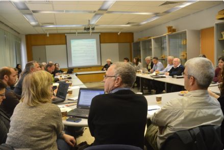
Nous avons eu une réunion avec nos conseillers internationaux. Pour cette réunion, cinq conseillers sont venus en Israël pour deux jours de réunions. Le deuxième jour, nous avons eu une session explicitement orientée vers l'examen des scénarios spatiaux envisagés pour le plan marin israélien. Nous avons ouvert l'outil SIG interactif ASDA sur un ordinateur portable et projeté le site sur un écran dans la salle de réunion. Les conseillers internationaux n'étaient pas familiarisés avec les aspects spatiaux du plan. Ils ont pu poser des questions, donner leur avis et obtenir des éclaircissements détaillés sur les emplacements spatiaux des utilisations actuelles et prévues de la zone maritime. L'ASDA nous a beaucoup aidés en nous permettant de consulter collectivement les informations. Nous étions une vingtaine de personnes assises autour d'une table. Outre l'avantage d'une visualisation collective, la possibilité de voir les couches d'information une par une, par exemple par secteur d'utilisation, nous a permis de voir où l'information prêtait à confusion et devait être améliorée. Nous avons passé environ une heure et demie à discuter avec les conseillers des différents aspects spatiaux du plan proposé.