Interactive and transparent approach in marine spatial planning
Full Solution


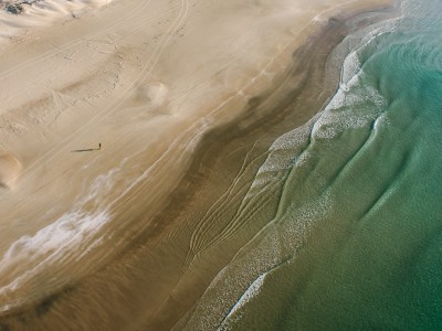
Israel's coastlin
Israel Bardugo
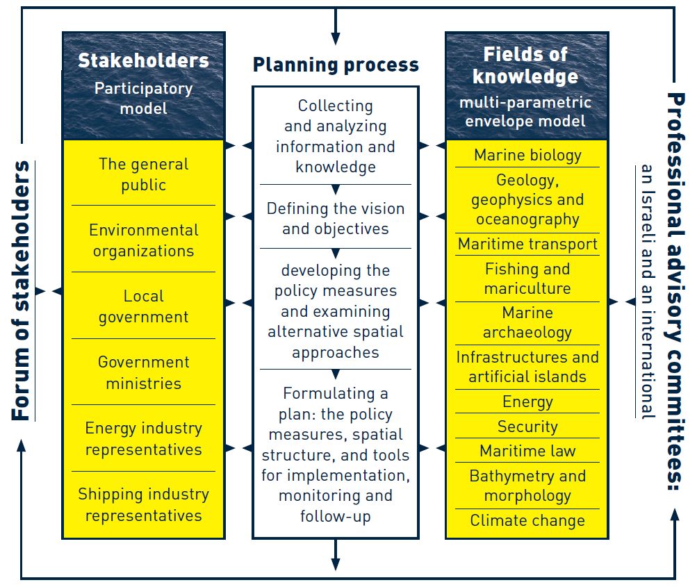
The solution addresses stakeholder participation for planning and management of Israel's marine space. An interactive web GIS platform has been developed to visualize the spatial distribution of different resource use in Israel's marine waters to promote awareness of the marine environment. It also addresses the issues of transparency and knowledge dissemination. Stakeholders are actively involved in the planning process and accompanied by local and international scientific advisory committees.
Last update: 28 Mar 2019
6057 Views
Photo and video gallery


Context
Challenges addressed
Lack of consolidated marine information; Difficulty envisioning spatial scenarios
• Lack of transparency regarding spatially explicit data
• Interfacing with the public, especially with those stakeholders that did not attend public meetings
• Lack of consolidated marine information and the diversity of uses that is accessible to the public
• Expense and time consumed in preparing physical hardcopy maps, changing them over time and viewing them at various scales in a time-efficient way
Location
Israel
West Asia, Middle East
Process
Building Blocks
Collection of current, extensive and relevant information
Good, reliable, detailed, accurate and current information is crucial. Either the authority/body providing the information needs to provide the information as GIS-compatible, or the solution implementer needs to convert various types of data into GIS data.
Enabling factors
The major conditions needed:
1) Funding
2) Sharing of data among authorities, most of them governmental
Lesson learned
Despite the considerable development in mapping, data collecting and research in recent decades, knowledge about the Israeli marine space in the Mediterranean, and in particular the deep sea that constitutes the greater part, is still very limited. Furthermore, there is a worrying absence of a national policy to promote marine research and data collecting, to provide sufficient funds for its development and make it accessible. The marine space still has fractured administration and limited governance and is severely lacking appropriate legislative tools.
All these are detailed at length in the Israel Marine Plan Stage 1 report are the foundation for defining the plan's objectives and for formulating policy measures for realizing them.
Resources
Compatibilities in the marine environment
To examine the way in which the different uses are incorporated in the marine space, two compatibility matrices have been developed to guide the proposed policy measures and spatial structure of this plan. These two matrices analyze:
1. Compatibility and conflict among the different uses
2. Compatibility and conflict between the different uses and the natural resources and heritage and cultural values
The two matrices were based on a list of uses in and values of the marine space – and a summary of the environmental impacts of each use, their significance and range. On the basis of the information collected, the relationships were categorized, cross-referencing the different uses, and relating to the degree of possible or desirable synergy between them.
Enabling factors
Sound and comprehensive data basis
Lesson learned
The time needed to map compatibilities is quite lengthy. A significant amount of time and resources are needed for mapping compatibilities. Resources include finding the right people and the right information to make well founding assumptions about impacts. Lastly, there will always be those stakeholders who don't agree with some information presented in the compatibilities matrices. They should be presented as "draft" and open to revisions over time.
Resources
GIS-based interactive decision making tool
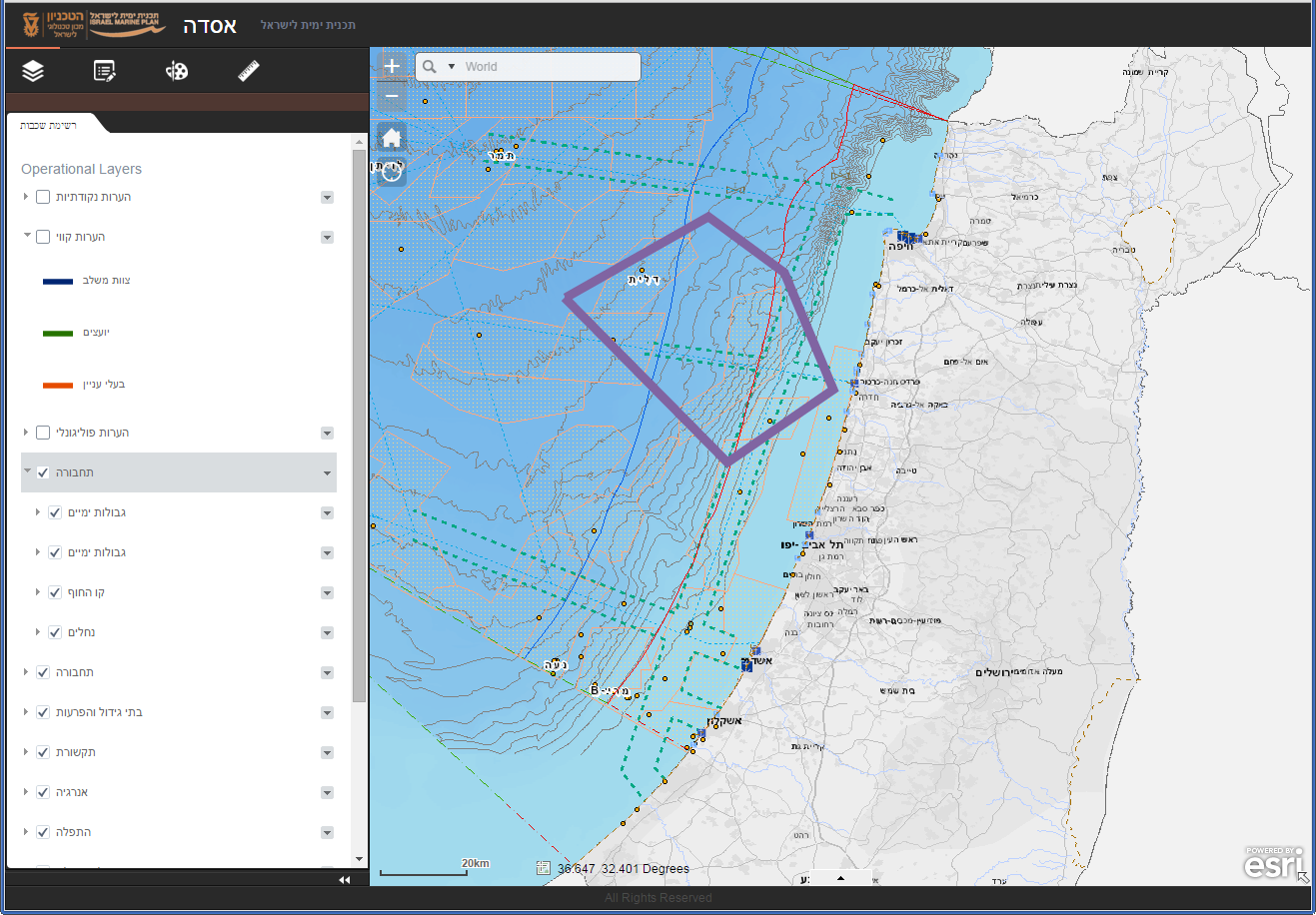
The ASDA GIS (Asda = platform in Hebrew) tool for marine spatial planning supports existing layers of information as well as the products of the ongoing planning process in an inclusive, flexible, visual, transparent, and participatory way. It allows experts and professional stakeholders from different disciplines to cross-reference and analyze data, respond and participate interactively, hold dialogue, and exchange spatial and textual ideas and opinions relating to planning the marine space. This tool serves all participants and showcases the plan’s products at its various stages. It provides solutions in three areas of activity: planning, participation, and management. The planning component is designed for professional experts and advisors from different disciplines, enabling group dialogue among experts & flexible and visual exchange of information and ideas regarding marine spatial planning; the participation component is designed for the general public & stakeholders, enabling observation of & reaction to the marine spatial plan’s work products; the management component is designed for decision makers at various levels, enabling spatial and statistical analyses as well as information-based reviews of development scenarios.
Enabling factors
1) Funding
2) Capacity (staff with GIS and programming skills)
Lesson learned
The lack of willingness of the planning staff to support the development of such a tool can be a major challenge. When planning the ASDA as part of the Israel Maine Plan, several planners were not supportive. They preferred to use hard-copy maps and thought the on-line tool would be a waste of time. Among the members of the core planning team, supporters made up about 50%. Having more young, internet savvy people, and perhaps more academics (interested in innovative solutions) on the core team could help solve this problem. Another activity that could have helped in this regard, would have been to monitor the use of the tool, thus "proving" its utility. In the end, this was not done systematically or thoroughly. There needs to be a certain openness to this type of tool, especially by those who are not familiar with the technology. Political and technical support is required not only for the development of the tool but also for promoting it and using it at every opportunity.
Resources
Participatory Planning
The Israel Marine Plan’s basic approach emphasizes that the marine space is essentially (ultimately) public. It aspires to view the different interests of all the stakeholders fairly and guarantee the provision of its ecosystem services over time. Through its goals, the plan offers way for informed and responsible management of the sea, applying an overall ecological approach. It aims to develop marine knowledge, to improve public awareness of what exists in the marine space, and to shape the way it is depicted spatially.
Stakeholders are actively involved in the planning process and accompanied by local and international professional scientific advisory committees. The planning process is supported by the use of the interactive GIS tool that helps to visualize resource use, potential conflicts, and management scenarios and thus enables comprehensive planning.
Enabling factors
1) Time needed to showcase and use the tool
2) Enthusiasm by those involved
3) Public relations for use of the tool (i.e., mentioning it at every opportunity, etc.)
Lesson learned
Lack of support among the core-team staff was a problem. Diversity of members on the team should be maintained (i.e., background, age, expertise, etc.). Time is crucial so that efforts are not rushed and full professionalism is maintained, especially for the compatibility matrices. This "solution" will not be appropriate in all situations; it depends on the level of funding, use of the internet and digital tools among the general population. After we started developing the tool we discovered that other organizations/entities had similar tools available. We could have tapped into these to avoid redundancy & improve base data. It would have been helpful to tie the information from the compatibility matrices to the ASDA tool so that one could see the compatibility and/or conflict found each areas as competing uses are selected. Monitoring usage of the tool would have been very helpful. High usage (and diverse usage) would generate more support for tool development and promotion.
Impacts
There is considerable potential in this area for developing and providing a variety of services to Israel's society and its economy, but also a serious threat to the delicate natural / ecological balance of the marine environment. If realized, this threat could harm the sensitive marine and coastal ecosystems and the services they provide. In the absence of a comprehensive plan for the marine space and effective tools for implementing it, these threats could cause irreversible damage.
The development of an interactive GIS online tool supports Israel’s marine spatial planning process through:
• Visualization of spatial distribution of bio-geographical features in Israel's marine waters;
• Visualization of spatial distribution of different sectoral activities in Israel's marine waters;
• Visualization of proposed allocation of activities, or groups of activities, in Israel's marine waters;
• Ability to assess the impacts and interactions of the proposed scenarios, designations and activities on bio-geographical features and existing activities
It therefore provides a repository of information in a one-stop shop.
Beneficiaries
Stakeholders and other resources users; Students (of marine/coastal policy, geography, political science, natural resource use); Planners and professionals taking part in the planning process; the wieder public
Story
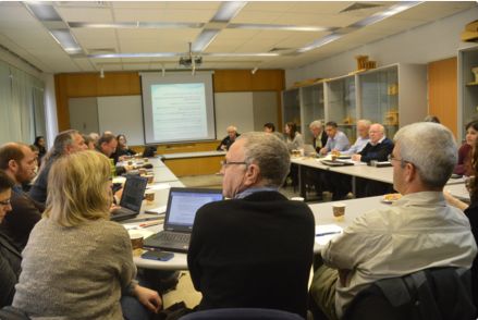
We had a meeting with our international advisors. For this meeting five advisors came to Israel for two days of meetings. On the second day we had a session explicitly directed towards consideration of the spatial scenarios considered for the Israel Marine Plan. We opened the ASDA interactive GIS tool on a laptop and projected the site on a screen in the meeting room. The international advisors were not familiar the spatial aspects of the plan. They were able to ask questions, give feedback and received detailed clarification about the spatial locations of ongoing and planned uses of the sea area. The ASDA was very helpful in allowing us to collectively view the information. We were about twenty of us seated around a table. Other advantages, in addition to convenient collective viewing, were the ability to see layers of information one by one, for example by use sector, and we had an opportunity to see where information was confusing and needed to be improved upon. We spent about an hour and a half discussing with the advisors various spatial aspects of the proposed plan.