Enfoque interactivo y transparente de la ordenación del espacio marino
Solución completa
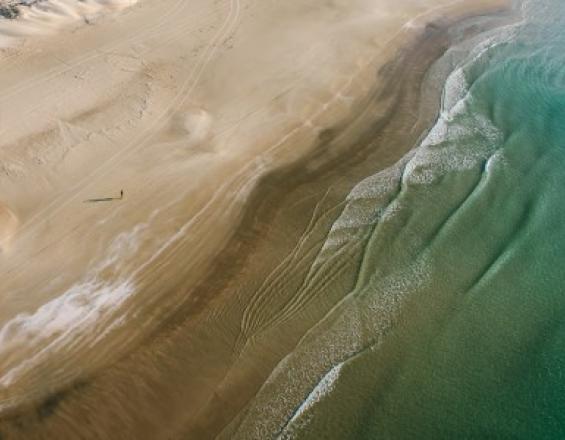
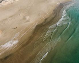
La costa israelí
Israel Bardugo
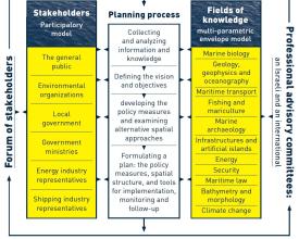
La solución aborda la participación de las partes interesadas en la planificación y gestión del espacio marino de Israel. Se ha desarrollado una plataforma SIG web interactiva para visualizar la distribución espacial de los distintos usos de los recursos en las aguas marinas de Israel con el fin de promover la concienciación sobre el medio marino. También aborda las cuestiones de transparencia y difusión de conocimientos. Las partes interesadas participan activamente en el proceso de planificación y cuentan con el acompañamiento de comités científicos consultivos locales e internacionales.
Última actualización: 28 Mar 2019
6057 Vistas
Contexto
Défis à relever
Falta de información marina consolidada; Dificultad para prever escenarios espaciales - Falta de transparencia en relación con los datos espacialmente explícitos - Interfaz con el público, especialmente con las partes interesadas que no asistieron a las reuniones públicas - Falta de información marina consolidada y de diversidad de usos accesible al público - Gasto y tiempo consumidos en preparar mapas físicos en papel, cambiarlos con el tiempo y visualizarlos a varias escalas de forma eficiente en el tiempo.
Ubicación
Israel
Oeste de Asia, Medio Oriente
Procesar
Bloques de construcción
Recopilación de información actual, amplia y pertinente
Es fundamental disponer de información buena, fiable, detallada, precisa y actualizada. O bien la autoridad/organismo que proporciona la información tiene que proporcionarla como compatible con el SIG, o bien el encargado de aplicar la solución tiene que convertir diversos tipos de datos en datos del SIG.
Factores facilitadores
Las principales condiciones necesarias son: 1) Financiación 2) Intercambio de datos entre autoridades, la mayoría de ellas gubernamentales.
Lección aprendida
A pesar del considerable desarrollo de la cartografía, la recopilación de datos y la investigación en las últimas décadas, el conocimiento del espacio marino israelí en el Mediterráneo, y en particular del mar profundo que constituye la mayor parte, sigue siendo muy limitado. Además, es preocupante la ausencia de una política nacional que promueva la investigación marina y la recopilación de datos, proporcione fondos suficientes para su desarrollo y la haga accesible. El espacio marino sigue teniendo una administración fracturada y una gobernanza limitada y carece gravemente de herramientas legislativas adecuadas.
Todos estos aspectos se detallan ampliamente en el informe de la primera fase del Plan Marino de Israel y constituyen la base para definir los objetivos del plan y formular medidas políticas para hacerlos realidad.
Recursos
Compatibilidades en el medio marino
Para examinar la forma en que los distintos usos se incorporan al espacio marino, se han elaborado dos matrices de compatibilidad que orientan las medidas políticas propuestas y la estructura espacial de este plan. Estas dos matrices analizan: 1. 1. Compatibilidad y conflicto entre los diferentes usos. 2. Compatibilidad y conflicto entre los diferentes usos. Las dos matrices se basan en una lista de usos y valores del espacio marino y un resumen de los impactos ambientales de cada uso, su importancia y alcance. A partir de la información recogida, se categorizaron las relaciones, cruzando los distintos usos y relacionándolos con el grado de sinergia posible o deseable entre ellos.
Factores facilitadores
Base de datos sólida y completa
Lección aprendida
El tiempo necesario para determinar las compatibilidades es bastante largo. Se necesita una cantidad considerable de tiempo y recursos para cartografiar las compatibilidades. Los recursos incluyen encontrar a las personas adecuadas y la información correcta para hacer suposiciones bien fundadas sobre los impactos. Por último, siempre habrá partes interesadas que no estén de acuerdo con alguna información presentada en las matrices de compatibilidades. Deben presentarse como "borrador" y estar abiertas a revisiones con el tiempo.
Recursos
Herramienta interactiva de toma de decisiones basada en SIG
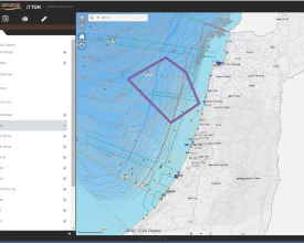
La herramienta ASDA GIS (Asda = plataforma en hebreo) para la ordenación del espacio marino respalda las capas de información existentes, así como los productos del proceso de planificación en curso, de una forma inclusiva, flexible, visual, transparente y participativa. Permite a expertos y profesionales interesados de distintas disciplinas cruzar y analizar datos, responder y participar de forma interactiva, dialogar e intercambiar ideas y opiniones espaciales y textuales relacionadas con la planificación del espacio marino. Esta herramienta sirve a todos los participantes y muestra los productos del plan en sus distintas fases. Ofrece soluciones en tres ámbitos de actividad: planificación, participación y gestión. El componente de planificación está pensado para expertos y asesores profesionales de distintas disciplinas, lo que permite el diálogo en grupo entre expertos y el intercambio flexible y visual de información e ideas sobre la ordenación del espacio marino; el componente de participación está pensado para el público en general y las partes interesadas, lo que permite observar los productos de trabajo del plan y reaccionar ante ellos; el componente de gestión está pensado para los responsables de la toma de decisiones a distintos niveles, lo que permite realizar análisis espaciales y estadísticos, así como revisiones basadas en la información de los escenarios de desarrollo.
Factores facilitadores
1) Financiación 2) Capacidad (personal con conocimientos de SIG y programación)
Lección aprendida
La falta de voluntad del personal de planificación para apoyar el desarrollo de una herramienta de este tipo puede ser un reto importante. Cuando se planificó la ASDA como parte del Plan Israel Maine, varios planificadores no la apoyaron. Preferían utilizar mapas impresos y pensaban que la herramienta en línea sería una pérdida de tiempo. Entre los miembros del equipo central de planificación, los partidarios representaban alrededor del 50%. Contar con más gente joven, conocedora de Internet, y quizá más académicos (interesados en soluciones innovadoras) en el equipo central podría ayudar a resolver este problema. Otra actividad que podría haber ayudado en este sentido habría sido supervisar el uso de la herramienta, "probando" así su utilidad. Al final, esto no se hizo de forma sistemática ni exhaustiva. Es necesaria una cierta apertura a este tipo de herramientas, especialmente por parte de quienes no están familiarizados con la tecnología. Se necesita apoyo político y técnico, no sólo para el desarrollo de la herramienta, sino también para promoverla y utilizarla en cada oportunidad que se presente.
Recursos
Planificación participativa
El planteamiento básico del Plan Marino de Israel hace hincapié en que el espacio marino es esencialmente (en última instancia) público. Aspira a considerar equitativamente los distintos intereses de todas las partes interesadas y a garantizar la prestación de sus servicios ecosistémicos a lo largo del tiempo. A través de sus objetivos, el plan ofrece vías para una gestión informada y responsable del mar, aplicando un enfoque ecológico global. Pretende desarrollar el conocimiento marino, mejorar la concienciación pública sobre lo que existe en el espacio marino y dar forma a su representación espacial. Las partes interesadas participan activamente en el proceso de planificación y cuentan con el acompañamiento de comités asesores científicos profesionales locales e internacionales. El proceso de planificación se apoya en el uso de la herramienta interactiva SIG, que ayuda a visualizar el uso de los recursos, los conflictos potenciales y los escenarios de gestión, permitiendo así una planificación integral.
Factores facilitadores
1) Tiempo necesario para mostrar y utilizar la herramienta 2) Entusiasmo de los implicados 3) Relaciones públicas para el uso de la herramienta (es decir, mencionarla en cada oportunidad, etc.)
Lección aprendida
La falta de apoyo entre el personal del equipo central fue un problema. Debe mantenerse la diversidad de los miembros del equipo (antecedentes, edad, experiencia, etc.). El tiempo es crucial para no precipitarse y mantener la profesionalidad, sobre todo en las matrices de compatibilidad. Esta "solución" no será adecuada en todas las situaciones; depende del nivel de financiación, del uso de internet y de las herramientas digitales entre la población general. Cuando empezamos a desarrollar la herramienta descubrimos que otras organizaciones/entidades disponían de herramientas similares. Podríamos haber recurrido a ellas para evitar redundancias y mejorar los datos de base. Habría sido útil vincular la información de las matrices de compatibilidad a la herramienta ASDA para poder ver la compatibilidad y/o el conflicto encontrado en cada área a medida que se seleccionan los usos que compiten entre sí. Habría sido muy útil supervisar el uso de la herramienta. Un uso elevado (y diverso) generaría más apoyo para el desarrollo y la promoción de la herramienta.
Impactos
En esta zona existe un potencial considerable para desarrollar y prestar diversos servicios a la sociedad israelí y a su economía, pero también una grave amenaza para el delicado equilibrio natural/ecológico del medio marino. De materializarse, esta amenaza podría dañar los delicados ecosistemas marinos y costeros y los servicios que prestan. A falta de un plan global para el espacio marino y de herramientas eficaces para aplicarlo, estas amenazas podrían causar daños irreversibles.
El desarrollo de una herramienta SIG interactiva en línea apoya el proceso de planificación del espacio marino de Israel a través de: - la visualización de la distribución espacial de las características biogeográficas en las aguas marinas de Israel; - la visualización de la distribución espacial de las diferentes actividades sectoriales en las aguas marinas de Israel; - la visualización de la asignación propuesta de actividades, o grupos de actividades, en las aguas marinas de Israel; - la capacidad de evaluar los impactos y las interacciones de los escenarios propuestos, las designaciones y las actividades en las características biogeográficas y las actividades existentes Por lo tanto, proporciona un repositorio de información en una ventanilla única.
Beneficiarios
Interesados y otros usuarios de los recursos; Estudiantes (de política marina/costera, geografía, ciencias políticas, uso de recursos naturales); Planificadores y profesionales que participan en el proceso de planificación; el público wieder
Historia
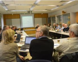
Tuvimos una reunión con nuestros asesores internacionales. Para esta reunión vinieron a Israel cinco asesores durante dos días de reuniones. El segundo día tuvimos una sesión dirigida explícitamente a estudiar los escenarios espaciales considerados para el Plan Marino de Israel. Abrimos la herramienta SIG interactiva ASDA en un ordenador portátil y proyectamos el sitio en una pantalla de la sala de reuniones. Los asesores internacionales no estaban familiarizados con los aspectos espaciales del plan. Pudieron hacer preguntas, dar su opinión y recibieron aclaraciones detalladas sobre la ubicación espacial de los usos actuales y previstos de la zona marítima. El ASDA nos ayudó mucho al permitirnos ver colectivamente la información. Éramos unos veinte sentados alrededor de una mesa. Otras ventajas, además de la cómoda visualización colectiva, fueron la posibilidad de ver las capas de información una por una, por ejemplo por sector de uso, y tuvimos la oportunidad de ver dónde la información era confusa y debía mejorarse. Dedicamos aproximadamente una hora y media a debatir con los asesores diversos aspectos espaciales del plan propuesto.

