Identifying MPA boundaries in the field
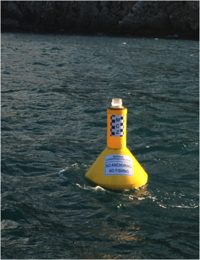
Marker buoy indicating a Marine Conservation Zone (ie a no-fishing & no-anchoring zone) in the Seven Sisters dive area, Gibraltar. However, be aware that aggrieved fishers have been known to drag marker buoys to ‘move’ zone boundaries.
Gibraltar News
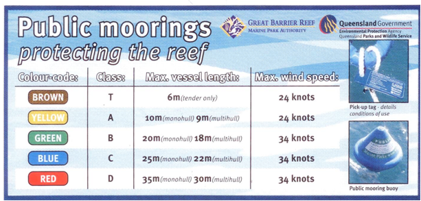
Information about the various classes of public moorings available in the Whitsunday Islands, GBR (note max. vessel lengths and max. wind speeds).
GBRMPA
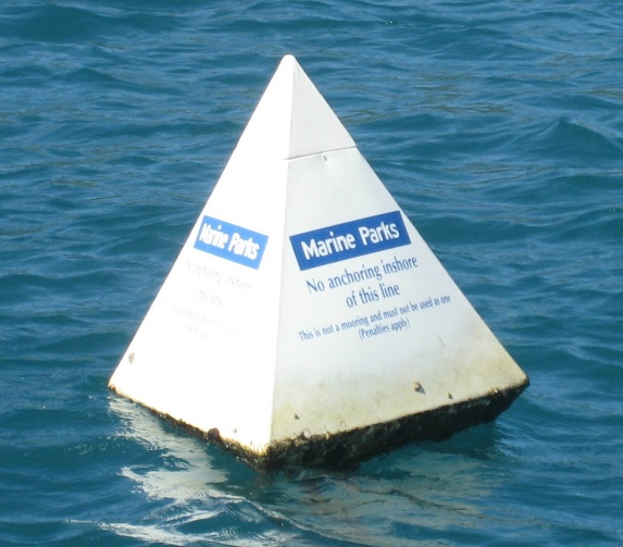
No-anchoring marker buoy in the Whitsunday Islands, GBR (one of several buoys in a line indicating no- anchoring inshore of the line).
QPWS
The boundaries of an MPA (or zones within an MPA) should be identifiable while on the water. Traditionally, inshore MPA boundaries were referenced to some obvious natural feature or by using a distance from a feature like the shoreline.
In some instances, physical demarcation of marine boundaries has occurred using fixed markers on the land or floating marker buoys, but there are significant costs to install and maintain such infrastructure.
For deepwater, open-ocean conditions or for large MPAs the placement of marker buoys is extremely difficult, if not impossible, and the cost is prohibitive. For these reasons, MPA managers delineate such offshore boundaries using GPS coordinates (see Resources for Coordinate-based zone boundaries).
Experience has shown that submerged features (e.g. depth contours, reefs, banks, shipwrecks, etc) may be hard to identify so should not be used for marine boundaries.
Florida Keys National Marine Sanctuary has considerable experience with installing offshore infrastructure for marine boundaries; FKNMS staff have installed >100 yellow boundary buoys marking marine zones; over 120 boundary buoys and/or signs marking Wildlife Management Areas, and are responsible for > 500 mooring buoys.
Best Practice approaches for boundary development are available (see Resources) to develop effective and accurate marine boundaries and definitions; these can help reduce boundary misunderstandings and possibly litigation.
• Mooring buoys can be excellent management tools, but concerns exist they can negatively impact marine resources by attracting and concentrating boaters, divers or fishermen to one location. Education programs must therefore accompany any mooring buoy program, with monitoring to assess any impacts.
• Reference to an identifiable geographic feature can help clarify a boundary location; however, the geographic coordinates will also help enforceability.
• An issue with MPA boundaries includes fishers ‘fishing the line’ with resulting edge-effects (i.e. MPA edges being more heavily impacted).
• If only a single land-based marker is used, the boundary may be seen to differ depending on which line of sight is viewed.
• Haste and inexperience can lead to poor MPA boundaries. Always ground-truth boundaries for accuracy and completeness.
• Shorelines may be ambulatory (i.e erode or accrete) so boundaries may be a problem to enforce if they move or are difficult to define.


