
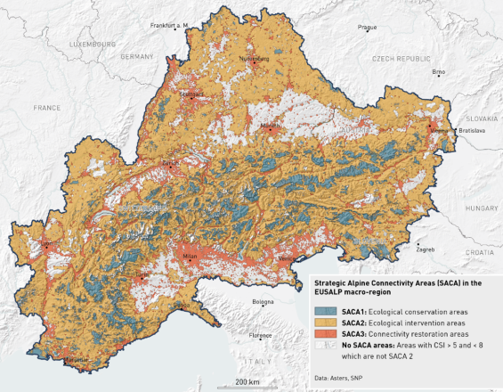
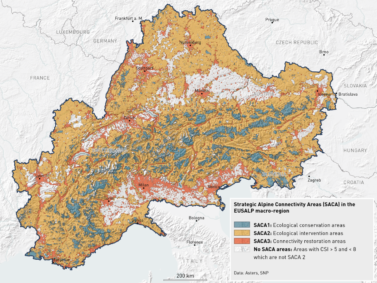
Strategic Alpine Connectivity Areas (SACA) in the EUSALP macro-region.
SNP
The ALPBIONET2030 project investigated for the first time where and to what extent the Alpine territory is suitable for ecological connectivity. It carried out a GIS based spatial analysis for the overall area of the European Alps. As a result of the analysis, three different types of Strategic Alpine Connectivity Areas (SACA) were defined: Ecological Conservations Areas (C1), Ecological Intervention Areas (C2) and Connectivity Restoration Areas (C3). The concept behind this categorization is that areas that are still valuable should be protected (C1), their habitat conditions should be improved and their surface probably expanded. Ecological Intervention Areas (C2) are those with conditions difficult for wildlife but also with realistic potential for improvement. Connectivity Restoration Areas (C3) are mainly the large Alpine valleys with high human impact, intensive land use and major barriers, where only specific restoration measures can help to improve the conditions of ecological connectivity.
Last update: 30 Sep 2025
1823 Views
Photo and video gallery
Context
Challenges addressed
Ecological connectivity is the basis of Alpine global habitat and species protection. However, with the fact that different regions have varying tools to measure and improve biodiversity, it becomes difficult to create an integrative concept for the protection of ecosystems and biodiversity within the Alps; a beautiful and unique European landscape rich in valuable habitats and structures, but endangered by over-exploitation and development. The overall objective of this project was to consolidate and enhance transnational cooperation in the field of nature conservation while providing a harmonized concept of preserving natural habitats and common planning tools to produce a high level ecological connectivity for biodiversity conservation.
Location
Zernez, Graubünden, Switzerland
Chambéry, Savoie, France
Vienna, Austria
Munich, Bavaria, Germany
Milan, Milan, Italy
Slovenia
West and South Europe
Process
Summary of the process
We understand building blocks as a sequence of actions that build on one another and of course have to interact with one another so that the goals can be achieved.
Building Blocks
Understanding the problem
We organized expert workshops to build a common base of the understanding, what ecological connectivity means and how we define it on a landscape level in different sectors (e.g. agriculture, forestry, urban planning).
Only in a second step methods, procedures and data were defined and implemented.
Enabling factors
An important factor for success was the ability to moderate between the individual representatives so that common solutions could be found.
Lesson learned
The process to bring all project partners from different countries to a common understanding and acting takes longer than the (technical) implementation itself.
Once, the first step is done and fully accepted, the technical solution can be developed on a solid basis.
Collection and harmonizing of the data
Collect and harmonize a bunch of spatial data to describe and map ecological connectivity from 6 independent states and numerous regions is probably the most challenging thing you can do in a GIS-project.
Enabling factors
- Describe precisely the data you need;
- Find the right person to establish the contacts to the data provider;
- Be able to handle manyfold data formats, structures and systems.
Lesson learned
They think that refusing to disclose data means that open questions are not answered.
JECAMI 2.0
As the extension 2.0 says, JECAMI 2.0 is an advancement of JECAMI 1.0. While the previous version concentrated on the suitability of ecological connectivity, JECAMI 2.0 implemented a new concept, the "Strategic Alpine Connectivity Areas (SACA) 1 - 3 to enhance the usability of specific measures.
We defined the following definitions of the 3 SACA types:
SACA1: Ecological conservation areas where ecological connectivity already works quite well (CSI ≥ 8). Ecological connectivity should be conserved in these areas.
SACA2: Ecological Intervention areas that represent important links between SACA1 areas (ecological conservation areas). Connectivity is currently working to some extent but would benefit from enhancements. In these areas, improvement / restoration measurements are needed.
SACA3: Connectivity restoration areas represent important barriers between SACA1 areas (ecological conservation areas)
Enabling factors
The definition of SACA types must be defined and accepted within the project group as well as by the observers of the project.
Lesson learned
Create a simplification of ecological connectivity to improve the understanding of the effect of a measure was a useful task to act on the right place.
Resources
Impacts
The results were used to raise awareness of stake holders especially for the international importance for ecological connectivity, but not only. In particular, the method was also implemented to support decision-making processes to reach the federal sustainability goals by the Swiss cantons.
Further, the produced maps and results were integrated in a teaching unit for high school students.
The outcomes of the project were made available for public on an online platform and through printed products in a popular scientific way, a printed atlas and a comic (see links below).
Overall, the project ALPBIONET2030 creates a reliable scientific outcome for integrative Alpine wildlife and habitat management for the next generation.
Beneficiaries
Wildlife protection services and protected areas management teams, through:
- multi-stakeholder and cross-border concept for integrated wildlife management in the Alps
- Identification of most important barriers around the Alps & Ecological Connectivity pathways
Story
The Swiss National Park is engaged in Alps-wide projects on ecological connectivity since 2004. The project ALPBIONET2030 is an important pearl withing the efforts to improve biodiversity and ecological connectivity in the Alps.
To be asked to map gaps and opportunities all over Switzerland and make some recommendations for the Swiss biodiversity strategy was a personal satisfaction. The topic became "common", the work can be continued on a higher and more productive level.