PyroSense
2018
PyroSense is a state-of-the-art system designed to proactively detect and prevent wildfires by integrating advanced technologies. It combines IoT sensors, 5G-enabled drones, AI-driven analytics, high-resolution cameras, and satellite weather data into a unified platform. Strategically deployed sensors continuously monitor environmental factors such as temperature, humidity, and CO2 levels in real time, as demonstrated in Syggros Forest. When the system detects anomalies that could indicate a fire, it instantly informs authorities with the coordinates of the event and deploys drones to the exact location. These drones stream live footage, which is analyzed by AI to identify potential fire threats, enabling a rapid response from firefighters and generating a Common Operational Picture (COP) among teams. By focusing on prevention rather than reaction, PyroSense has successfully stopped two fire outbreaks in Syggros Forest, ensuring that stakeholders receive real-time updates for informed decision-making and effective planning.
Last update: 12 Nov 2025
261 Views

Context
Challenges addressed
Environmental Challenges
Environmentally, it combats biodiversity loss, air quality degradation (reducing smoke and greenhouse gases), soil erosion, water contamination, and forest degradation by enabling early detection and rapid containment, thus preserving ecosystems and natural resources.
Social Challenges
Socially, enhances safety by reducing risks to human life and injury through early warnings and optimized response routes. It minimizes community displacement, health impacts from smoke exposure, and psychological trauma by preventing large-scale fires and ensuring community stability.
Economic Challenges
Economically, the solution mitigates property and infrastructure damage, protects tourism and industries, and significantly reduces costly firefighting operations. By lowering fire risk, it can also lead to more stable insurance costs and prevents the depletion of valuable resources. In essence, PyroSense offers a comprehensive solution that safeguards natural environments, human lives, communities, and economic stability.
Location
Skiathos, Thessaly, Greece
Μαρούσι, Περιφέρεια Αττικής, Ελλάδα
Athalassas, 2019 Στρόβολος, Κύπρος
Κως, Περιφέρεια Νοτίου Αιγαίου, Ελλάδα
West and South Europe
Process
Summary of the process
The success of PyroSense comes from the effective interaction among its core components. The foundational layer involves Data Sources and Monitoring, which continuously supply real-time environmental, visual, and biometric data. This raw data is processed by Technical Interventions and Infrastructure, including AI/ML modules that analyze sensor readings, drone footage, and firefighter wearables, transforming it into actionable insights.
These insights are utilized in Geospatial Planning and Risk Mapping to identify fire locations, simulate spread, and optimize response routes. The resulting spatial intelligence supports strategic decision-making. Lastly, the Communication, Outreach, and Awareness block ensures that critical updates, such as real-time alerts and resource locations, are shared with stakeholders through a dedicated web application and automated alerts. This timely and tailored communication enables coordinated action and informed decisions, ultimately contributing to the overarching goal of Technology for Nature Conservation by facilitating proactive fire prevention and rapid, efficient response, thereby minimizing environmental damage and protecting ecosystems.
Building Blocks
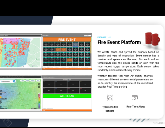
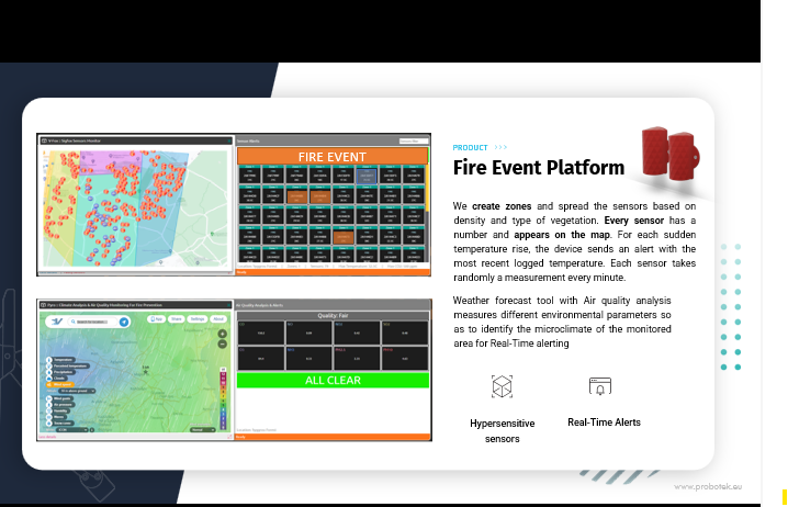
Comprehensive Data Ingestion for Fire Detection
This is the comprehensive intake mechanism for all information vital to PyroSense's platform. Its purpose is to gather real-time data, from multiple origins, ensuring the system has the input needed for accurate analysis and effective decision-making.
PyroSense integrates an agnostic and highly compatible array of data:
Environmental IoT Sensors are strategically deployed, and continuously collect real-time CO2, temp. and humidity data. They are agnostic in type and protocol, compatible with MQTT, LoRa, Sigfox, and NBIoT, ensuring broad integration. For efficiency, they feature long-lasting batteries (up to 10 years), minimising maintenance.
Fixed cameras and drones capture high-resolution images and live video. Integrated Vision AI processes this visual data in real-time to detect anomalies like smoke or fire.
PyroSense gathers data from local weather stations and satellites. Combining granular local data with broad satellite coverage provides a comprehensive understanding of current weather.
GIS provides foundational spatial information, including maps of terrain, vegetation, infrastructure, etc.
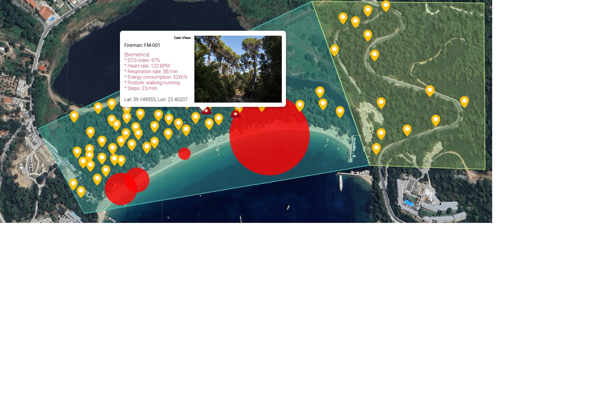
Firemen Wearables monitor real-time biometrics. AI enhances data for risk pattern recognition, of fatigue or heat stress. Real-time alerts are sent to nearby teams or control centers, enabling proactive intervention.
Enabling factors
- Reliable Sensor Deployment: Sensors should be strategically placed, well-installed, ensuring continuous data collection and security.
- Data Stream Integration: Integrating data from various sensors, cameras, drones, and meteorological sources is crucial for situational awareness.
- Data Quality and Calibration: Ensure all data sources are calibrated and high quality to avoid false alarms.
- Secure Data Transmission: A strong communication is vital for secure, low-latency data transfer from remote locations.
Lesson learned
The diversity and agnosticism of data sources are critical for comprehensive and resilient fire detection. Relying on a single type of sensor or communication protocol creates vulnerabilities. The ability to integrate data from various IoT sensors, visual feeds (cameras, drones), meteorological data, and even human biometrics provides a robust, multi-layered detection system that significantly reduces false positives and increases detection accuracy.
- The platform must be software and hardware agnostic.
- Cybersecurity and intercommunication are crucial.
A significant challenge was ensuring seamless interoperability between different sensor types and communication protocols (e.g., MQTT, LoRa, Sigfox, NBIoT) from various manufacturers. As well as, maintaining connectivity in remote, terrains for all sensor types was also an ongoing effort, despite long battery life.
- Design your system to be compatible with multiple IoT communication protocols from the outset.
- Develop algorithms for data validation and fusion to cross-reference information from disparate sources.
- Consider hybrid communication solutions (e.g., satellite for remote areas)
Spatial Intelligence for Wildfire Management
This building block provides the essential spatial intelligence for PyroSense, enabling a dynamic understanding of the geographical landscape. Its core purpose is to identify fire risk areas, pinpoint incident locations, and visualize resource deployment. This is crucial for strategic decision-making, allowing proactive resource allocation, and response planning.
PyroSense utilizes a robust Geographic Information System (GIS) to power this function. The GIS integrates various spatial data layers, including topography, vegetation, infrastructure, etc. Initially, baseline risk maps are created by analyzing factors, guiding the placement of sensors and cameras.
Upon detection of a potential fire by environmental sensors or AI, the system immediately feeds the precise coordinates into the GIS. This real-time location data, combined with meteorological data (local and satellite), enables dynamic risk assessments. The GIS also serves as a central operational dashboard, visualizing the real-time positions of all deployed assets, including drones and first responder teams. This facilitates optimal resource allocation and coordination. This critical information is then communicated via a web application to stakeholders, providing clear visual situational awareness and supporting informed decision-making.
Enabling factors
- Accurate and Up-to-Date GIS Data: Access to current geospatial data on topography, vegetation, historical fire activity is essential for reliable risk assessments.
- A powerful GIS platform is necessary for integrating diverse data layers, performing complex analyses, and running real-time AI.
- Expertise is needed to interpret GIS data, validate models, and use the platform for strategic planning and incident management.
- Connectivity with environmental sensors, drone feeds, and meteorological data is crucial for dynamic risk mapping and accurate fire tracking.
Lesson learned
The accuracy and utility of geospatial planning are directly proportional to the quality and timeliness of the underlying GIS data. Investing in high-resolution, frequently updated maps and environmental data is paramount. Furthermore, the ability to integrate real-time sensor and drone data into the GIS for dynamic risk assessment proved to be a game-changer, moving beyond static planning to predictive capabilities.
Initial challenges included the significant effort required to collect and digitize comprehensive baseline GIS data for large, remote areas. Data standardization across different sources (e.g., various government agencies, local surveys) was also a hurdle. Additionally, ensuring the GIS platform could handle the computational load of real-time data fusion and complex fire spread simulations without latency issues was a technical challenge.
- Before deployment, dedicate substantial resources to acquiring and standardizing all relevant geospatial data.
- Choose a GIS platform that can scale with increasing data volumes and computational demands.
- Ensure that local teams are proficient in using the GIS platform
Stakeholder Communication & Wildfire Awareness
This system translates PyroSense's advanced data into actionable intelligence, ensuring that the right people— from first responders to community members— are informed and prepared at the right time. Its primary goal is to share critical information about fire risks, incidents, and response efforts promptly and accurately. Effective communication is crucial in emergency management, as it facilitates coordination, reduces panic, and supports informed decision-making.
How it works in PyroSense:
- Real-time Incident Communication: When an alarm is triggered by PyroSense, the web platform displays precise fire coordinates and the geolocation of all deployed resources on a comprehensive GIS map, facilitating better planning and coordination.
- Emergency services receive detailed operational data, while communities are given simplified alerts and areas to avoid.
- PyroSense integrates with automated alert systems like SMS and email, ensuring critical information reaches stakeholders even when they aren't monitoring the web app, maximizing reach and redundancy.
This initiative uses PyroSense data to drive public fire prevention campaigns, engage communities in understanding fire risks, and foster preparedness plans, while also enhancing educational materials on wildfire mitigation.
Enabling factors
- Reliable Communication Infrastructure: A robust communication network is vital for timely alerts in emergencies.
- User-Friendly Interfaces: The web application and tools should be intuitive and provide clear information for different user groups.
- Defined Communication Protocols: Clear protocols for communication are necessary to avoid confusion and ensure efficient information flow during incidents.
- Stakeholder Engagement and Training: Regular training and engagement with all stakeholders are essential for effective response and awareness
Lesson learned
Effective communication is not just about sending alerts; it's about delivering the right information, to the right people, at the right time, in an understandable format. Tailoring messages to different stakeholder groups (e.g., detailed operational data for firefighters, simplified alerts for the public) is crucial for effective response and preventing panic. Building trust through consistent and reliable communication is also paramount.
Initially, there was a tendency to send too much technical data to all stakeholders, leading to information overload and confusion. Ensuring reliable communication channels in remote areas or during power outages was also a challenge. Gaining community trust and encouraging proactive engagement (e.g., reporting suspicious activities) required sustained effort beyond just providing a web app.
- Develop distinct communication strategies and message formats for different stakeholder groups.
- Information should be clear, concise, and directly actionable.
- Build Redundant Communication Channels (web app, SMS, email, public address systems) to ensure messages get through, especially during emergencies.
Core Technologies & Supporting Infrastructure
This building block represents the tangible, physical, and digital components that enable the solution. Its purpose is to provide the necessary tools, systems, and underlying support structures for data collection, processing, analysis, as well as for executing automated and human-led responses.
How it works in PyroSense:
Sensor Network Deployment involves strategically placing IoT environmental sensors with long-lasting power (up to 10 years) and reliable communication methods (MQTT, LoRa, Sigfox, NBIoT) for data transmission from remote locations.
Drone Systems and 5G: This involves drones equipped with high-resolution cameras and Vision AI, relying on 5G networks to enable real-time video streaming.
Centralized Data Platform and Cloud Infrastructure for extensive data analysis and computational power for data fusion, and AI models.
Artificial Intelligence (AI) enhances system intelligence through algorithms for anomaly detection in sensor data, and in image/video analysis for smoke and flame detection.
Web Application and User Interface (UI) for human interaction, to access real-time information, view maps, receive alerts, etc.
Wearable Technology for Firefighters: This includes biometric sensors, and software for data analysis to enhance responder safety through risk assessment and alerts.
Enabling factors
- IT infrastructure handled increasing data volumes and user loads while being resilient to disruptions.
- Ongoing development and integration of advanced AI and ML models are crucial for system accuracy and predictive capabilities.
- Interoperability of Components: All hardware and software communicate seamlessly to form an integrated system.
- Regular Maintenance and Upgrades: Consistent maintenance and upgrades of hardware and software are necessary for optimal performance and to adapt to new challenges.
Lesson learned
The robustness and scalability of the underlying technical infrastructure are non-negotiable. Investing in high-quality, resilient hardware and a flexible, cloud-based software architecture is essential for handling large data volumes, supporting real-time operations, and ensuring system uptime.
AT the same time initial deployments faced issues with hardware durability in harsh environmental conditions (extreme temperatures, dust, moisture). Ensuring seamless integration and interoperability between components from different vendors proved more complex than anticipated. Managing power supply for remote sensors and drones was also a continuous challenge, despite long battery life claims.
- Select hardware designed to withstand the specific environmental conditions of the deployment area.
- Design the system with a modular architecture and open APIs to facilitate integration of diverse components and future upgrades.
- Implement robust power solutions for remote devices, including solar charging and long-life batteries.
- A dedicated team with expertise is crucial for successful deployment, maintenance, and troubleshooting.
Protecting Ecosystems Through Fire Prevention Technology
This building block outlines PyroSense's commitment to safeguarding natural ecosystems and biodiversity from wildfires through advanced technology. PyroSense aims to prevent environmental damage that traditional firefighting struggles to address.
Key mechanisms include:
- Proactive Fire Prevention: Utilizing IoT sensors and AI analysis, PyroSense detects environmental anomalies early, allowing for intervention before fires escalate, thus minimizing ecological damage and protecting habitats.
- Reducing Firefighting Impact: Early detection and precise targeting lessen the need for resource-intensive firefighting, resulting in lower water use and reduced ground disturbance.
- Biodiversity Protection: Real-time alerts and predictive simulations enable timely actions to protect wildlife and critical ecological areas, contributing to biodiversity preservation.Air Quality Improvement: By preventing large-scale wildfires, PyroSense helps lower emissions of smoke and greenhouse gases.
- Ecosystem Resilience: Minimizing fire frequency and severity supports natural regeneration and maintains ecosystem resilience against degradation.
- Data-Driven Conservation: Collected environmental data, combined with GIS mapping, aids in land management, habitat restoration, and conservation planning.
Enabling factors
- The technology is aligned with nature conservation objectives to enhance ecological health and protect biodiversity.
- Collaborating with ecologists is essential to address ecosystem vulnerabilities and ensure effective technological interventions.
- Ongoing investment in development and maintenance is crucial for the technology’s lasting impact on natural environments.
- Building trust and cooperation with local communities is vital for successful conservation efforts.
Lesson learned
The direct application of advanced technology for nature conservation, specifically wildfire prevention, yields tangible and significant environmental benefits. Proactive detection and rapid response capabilities demonstrably reduce the scale and severity of wildfires, thereby preserving biodiversity, ecosystems, and natural resources. The data collected by such systems also provides invaluable insights for long-term conservation planning and ecological restoration efforts.
Now quantifying the exact ecological impact of prevented fires can be challenging, making it difficult to fully articulate the return on investment for conservation efforts. Gaining widespread acceptance and funding from traditional conservation organizations, who may be more accustomed to conventional methods, required demonstrating clear, measurable environmental outcomes.
- Establish clear, measurable environmental indicators (e.g. emissions reduced) to demonstrate the impact.
- Partner with experts like ecologists, and biologists, from the outset. Their expertise is vital for understanding ecosystem needs.
- Document and publicize successful fire prevention event
Impacts
The PyroSense solution delivers significant and measurable positive impacts across environmental, social, and economic dimensions, transforming wildfire management from a reactive to a proactive paradigm. Its integrated approach safeguards natural assets, enhances community well-being, and provides substantial financial benefits.
PyroSense's core strength lies in its ability to prevent fires from escalating, directly contributing to environmental preservation. By enabling early detection and rapid intervention, the system minimizes the scale of destruction. For instance, in its initial deployment, PyroSense successfully prevented two fire outbreaks at Syggros Forest. This proactive capability directly translates to:
- Reduced Habitat Loss and Biodiversity Protection
- Improved Air Quality and Climate Change Mitigation
- Preservation of Ecosystem Services
- Minimized Firefighting Environmental Footprint
The social benefits of PyroSense are profound, directly enhancing the safety and resilience of communities and first responders:
- Enhanced Community Safety and Well-being
- Improved Firefighter Safety
- Empowered and Informed Stakeholders
- Reduced Health Risks
PyroSense offers substantial economic advantages by mitigating the costly consequences of wildfires:
- Reduced Property and Infrastructure Damage
- Lower Firefighting and Recovery Costs
- Preservation of Economic Livelihoods
- Maintained Tourism and Recreation
Beneficiaries
- Governments
- Local Communities
- Emergency Response Teams and local public safety agencies
- Tourism Operators/Businesses and Visitors
- Conservationists and Environmentalists
- Insurance Providers
Additionally, explain the scalability potential of your Solution. Can it be replicated or expanded to other regions or ecosystem?
PyroSense represents a paradigm shift in wildfire management, moving beyond reactive suppression to a proactive, intelligent, and highly adaptable solution. Its design inherently supports broad applicability and expansion, while directly contributing to critical global sustainability objectives and addressing long-standing challenges in environmental protection.
The inherent scalability of the PyroSense solution is a cornerstone of its design, enabling seamless replication and expansion across a multitude of geographical regions and ecological systems. This adaptability stems from its modular architecture, agnostic technological compatibility, and cloud-centric operational framework.
PyroSense is engineered for straightforward deployment in new environments, underpinned by several strategic design principles:
Modular Component Design: Each fundamental element of PyroSense—including environmental sensors, drone systems, advanced AI modules, and the user-facing web application—is conceived as an independent, yet fully interoperable, module. This modularity ensures that new units can be effortlessly deployed and integrated, whether into an existing system or a newly established instance of the central platform. For example, extending coverage to an adjacent forest merely requires the strategic placement of additional sensor networks, which then seamlessly connect to the core system.
- Agnostic Sensor and Protocol Compatibility: A key innovation is PyroSense's compatibility with a wide array of IoT sensor types and communication protocols, such as MQTT, LoRa, Sigfox, and NBIoT. This vendor-agnostic approach liberates the system from reliance on proprietary hardware or single-source technologies. It empowers implementers to select the most appropriate and economically viable sensors tailored to specific local conditions, existing infrastructure, or unique environmental demands, thereby significantly simplifying and de-risking deployment in varied regions.
- Standardized Deployment Procedures: The entire deployment process, encompassing sensor installation, drone configuration, and central platform setup, is meticulously standardized and thoroughly documented. This systematic approach facilitates efficient replication by trained personnel in new areas, ensuring consistency and reducing deployment complexities. Comprehensive guidelines for optimal sensor placement, informed by local topography, vegetation types, and prevailing environmental factors, are integral to these procedures.
- Cloud-Based Platform: The central data processing, analytics, and command-and-control platform operates entirely within a cloud environment. This architecture allows for rapid provisioning and expansion of the system in any geographical location without necessitating substantial on-site IT infrastructure investments. The inherent global accessibility and elastic scalability of cloud computing are paramount for rapid and cost-effective replication, enabling quick deployment in remote or underserved areas.
- Adaptable AI Models: While PyroSense's AI models are initially trained on specific datasets, their underlying framework is designed for remarkable adaptability. These models can be retrained and optimized in real-time using localized data from new regions without interrupting ongoing services. This continuous, iterative learning process ensures that the AI's performance remains optimal and accurate, even when confronted with unique environmental conditions, fire behaviors, or specific ecological characteristics of a new deployment area.
Beyond simple replication, PyroSense is inherently designed for dynamic expansion, allowing for increased scope and coverage within both existing and new deployments:
- Increased Geographical Coverage: The system's monitoring footprint can be readily expanded to encompass larger geographical areas through the incremental deployment of additional sensors, cameras, and drones. The modular nature of the components ensures that each new data collection point seamlessly integrates, proportionally enhancing the system's overall monitoring capabilities.
- Enhanced Sensor Density: In areas identified as high-risk or critical zones, the density of environmental sensors can be strategically increased. This provides more granular data resolution and facilitates even earlier detection capabilities, all without requiring a complete overhaul of the existing system infrastructure.
- Integration of New Data Streams: PyroSense's flexible data ingestion architecture is designed to accommodate the integration of novel data sources as they emerge or become relevant. This foresight allows for the incorporation of advanced satellite imagery products, more sophisticated meteorological models, or even community-sourced observations, continuously enriching the system's analytical capabilities.
- Addition of New Features and Analytics: Given the software-defined nature of its AI and analytics modules, PyroSense can evolve to incorporate new functionalities. More sophisticated predictive models, enhanced risk assessment algorithms, or novel alert mechanisms can be developed and deployed as seamless updates to the existing platform, ensuring continuous improvement and adaptation.
- Scalable Computing Resources: The underlying cloud infrastructure provides on-demand scalability for both computing power and data storage. As the volume of data inevitably increases with geographical or functional expansion, backend resources can be dynamically adjusted to maintain optimal performance without requiring manual intervention or significant capital expenditure.
- Multi-Ecosystem Adaptability: While initially optimized for forest fire detection, the core technological principles of PyroSense—remote sensing, advanced data fusion, AI-driven anomaly detection, and real-time communication—are inherently transferable. Furthermore, the foundational technology can be extended to monitor other climate and environmental phenomena, including floods, earthquakes, or ecological shifts. Successful adaptation requires adjusting specific parameters for risk assessment and retraining AI models to account for the unique characteristics and environmental variables of each new context.
Concerning PyroSense's operational framework and inherent capabilities enables seamless alignment with key international sustainability objectives, most notably the United Nations Sustainable Development Goals (SDGs). Its contributions extend beyond immediate fire suppression, fostering long-term resilience and ecological integrity on a global scale.
SDG 13 (Climate Action)
Wildfires are increasingly seen as both a consequence and accelerant of climate change, creating a destructive feedback loop. Large-scale wildfires release significant greenhouse gases (CO2, methane, black carbon), worsening global warming. PyroSense tackles this issue by providing real-time wildfire detection and enabling quick responses, thereby preventing small fires from escalating into larger ones. This not only reduces greenhouse gas emissions but also helps preserve forests, which are vital for carbon sequestration. By mitigating large-scale carbon emissions from wildfires, PyroSense supports efforts to combat climate change and promotes a more stable climate future.
SDG 15 (Life on Land)
Terrestrial ecosystems, including forests and wetlands, are highly vulnerable to wildfire damage. They provide essential services like habitat for species, water regulation, and soil stabilization. Uncontrolled wildfires result in significant biodiversity loss and ecological degradation. PyroSense aids in the protection and restoration of these ecosystems by facilitating rapid responses to wildfires, minimizing damage, and preserving critical habitats. This proactive approach promotes biodiversity, prevents soil erosion, and accelerates ecological recovery. By reducing the frequency and intensity of wildfires, PyroSense helps maintain vital ecosystem services, essential for sustaining life and achieving ecological balance.
SDG 11 (Sustainable Cities and Communities)
Wildfires in wildland-urban interfaces (WUI) threaten human settlements, infrastructure, and health, causing property damage and displacement. PyroSense enhances community resilience by providing advanced early warning systems and coordinating responses in fire-prone areas. It prevents fires from reaching populated zones, protecting homes and minimizing economic and social disruption. With real-time communication, communities receive timely alerts and evacuation instructions, ensuring safety and promoting organized responses. This comprehensive protection helps make settlements inclusive, resilient, and sustainable, supporting long-term stability and prosperity.
In summary, PryoSense is specifically engineered to address long-standing challenges and critical gaps that have historically hampered traditional wildfire management strategies, fundamentally shifting the paradigm from reactive suppression to proactive prevention and intelligent, data-driven response.
Early Detection
One of the major challenges in wildfire management is the delayed detection of ignitions. By the time a fire is confirmed, it often has gained significant momentum, complicating containment efforts. PyroSense addresses this issue with advanced multi-modal detection capabilities. It utilizes a network of agnostic IoT sensors (compatible with MQTT, LoRa, Sigfox, and NBIoT, with battery lives up to 10 years) to monitor environmental indicators like CO2, temperature, and humidity. Simultaneously, AI-driven vision systems on fixed cameras and 5G-enabled drones provide real-time confirmation of smoke or flames. This integrated approach enables detection within minutes of ignition, resulting in quicker response times and allowing firefighters to act before fires escalate. Early intervention ultimately saves lives, protects property, and preserves natural resources.
Data Integration
Traditional wildfire management often struggles with fragmented data, leading to delays in understanding the situation and hindering decision-making. PyroSense addresses this by consolidating data from various sources into a unified operational picture. It uses real-time data from IoT sensors, high-resolution visuals from cameras and drones, meteorological information, GIS data, and firefighter biometrics. This integration enhances situational awareness, allowing for accurate risk assessments by correlating different data points. As a result, PyroSense minimizes false positives and supports timely, effective responses, enabling more strategic resource allocation and response planning.
While, the tangible impact and profoundly innovative nature of PyroSense's contributions are demonstrably evident across several key performance indicators, underscoring its transformative potential in wildfire management and environmental protection.
Reduced Response Times
PryoSense revolutionizes wildfire response by accelerating detection and notification processes. Its automated alarm system, combined with 5G-enabled drones for real-time assessment, significantly shortens the time between fire ignition and the arrival of firefighting resources. This rapid intervention has proven effective, as seen in Syggros Forest, where it successfully prevented two fire outbreaks, demonstrating its operational efficiency.
Quantifiable Outcomes
PryoSense offers actionable metrics for evaluating its impact, including the number of fires detected and contained early, reduced burned areas, optimized resource utilization, and substantial cost savings in fire suppression and ecological restoration. These metrics provide stakeholders with a clear return on investment and support ongoing system improvements.
Innovative Technology
PryoSense integrates advanced technologies to enhance wildfire monitoring and response. With IoT sensors for environmental monitoring, 5G-enabled drones for aerial assessment, Vision AI for smoke and flame detection, it represents a significant advancement in wildfire management. Additionally, AI-enhanced wearables for firefighters ensure heightened safety. This cutting-edge system transforms wildfire prevention, detection, and control.
Global Biodiversity Framework (GBF)
GBF Target 3 – Conserve 30% of Land, Waters and Seas
GBF Target 8 – Minimize the Impacts of Climate Change on Biodiversity and Build Resilience
Sustainable Development Goals
SDG 3 – Good health and well-being
SDG 9 – Industry, innovation and infrastructure
SDG 11 – Sustainable cities and communities
SDG 13 – Climate action
SDG 15 – Life on land
SDG 17 – Partnerships for the goals
Story
Everything started in 2018 with the Marathonas Mati wildfire. It was a devastating event that claimed the lives of over 100 people in the coastal town near Athens. The fire spread rapidly, fuelled by strong winds, and many residents were trapped with no clear evacuation routes. Investigations later found that inadequate emergency planning, poor coordination, and a lack of early warning systems contributed to the high death toll. This was the pain point that we decided to develop a system that would help to mitigate such phenomenon and prevent experiencing such events. In the aftermath of Mati, there was a renewed focus on developing more robust wildfire monitoring and early warning capabilities. Advanced sensor networks, satellite imagery analysis, and machine learning algorithms can now detect the early signs of fire more quickly and accurately. This information can then trigger emergency alerts, activate evacuation procedures, and dispatch firefighting resources in a timely manner. The goal was to provide critical minutes of additional warning time, enabling authorities and residents to respond more proactively and avoid the kind of tragic outcomes seen in Mati.
So we came up with PyroSense, a platform that:
- enforces existing protection systems and measures taken by first responders,
- mitigates exposure to unknown environmental threats by providing real-time view,
- provides a common operational picture for strategic planning in real-time and more effective coordination, and
- digitizes everything to have the records to analyze afterwards what we did wrong or what we did right to improve performance and future planning.