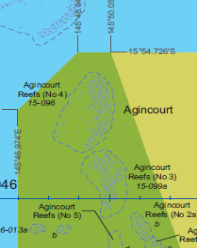


Zone boundaries may be described as a specified distance from the edge of a geographical feature (e.g. ‘500 m from the reef edge’). This normally results in an irregular shaped zone boundary. Depicting a reef or a group of reefs in this way may look ecologically appropriate on a map, but using the edge of such features to draw zone boundaries has proven very difficult to interpret on the water. For example, many reef parts are fragmented or at times submerged, so it is difficult on the water to determine the reef edge, and then use that to estimate a distance. Furthermore it is not easy to estimate 500 m (or even 100 m) on the water. Coordinate-based zone boundaries, based on longitude/latitude and shown in degrees and decimal minutes were therefore introduced in the 2003 GBR Zoning Plan. These fully encompass ecological features (i.e. well outside the edge of entire reefs/islands). Zone boundaries are orientated north, south, east and west for ease of navigation or comprise straight lines between two easily determined coordinates. Straight lines look less ‘ecologically appropriate’, but they are easier to locate and enforce in offshore areas, especially if using electronic devices e.g. global positioning system GPS or plotter.
Building on the existing zoning, it is important that every zone has a unique number, referenced to a detailed description in the statutory Zoning Plan (see Resources) and with a unique zone identifier (e.g. MNP–11–031): a) MNP refers to the zone type (Marine National Park Zone) b) the first two numbers refer to its latitude (example shown above is at latitude 11°) c) The last number (031) enables a specific zone to be identified on the zoning maps and cross-referenced to the Zoning Plan.
- Not every zone coordinate is shown on the freely available zoning maps; however the most important zone coordinates for most users are shown (e.g. no-fishing zones and no-access zones).
- Recognizing that not everyone has a GPS, inshore zone boundaries, however, are aligned with recognizable coastal features or identifiable landmarks or boundary markers (e.g. ‘the zone extends north from the eastern extent of the headland at xxx’).
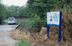
- Signs showing the nearby zones are put at boat ramps along the coast (see Photos below).
- All zoning coordinates are provided to commercial suppliers of electronic navigation aids, enabling zones to be loaded into a GPS.
- In addition, all zone coordinates are freely available on the web or available as a CD to enable any user to plot the coordinates on their own navigation chart, or to locate a zone using their own GPS.
- All coordinates must be referenced to a specified official Geocentric Datum for accuracy (e.g. GDA94 in Australia).