

Measuring Ecosystem Services at a Landscape Level
Full Solution

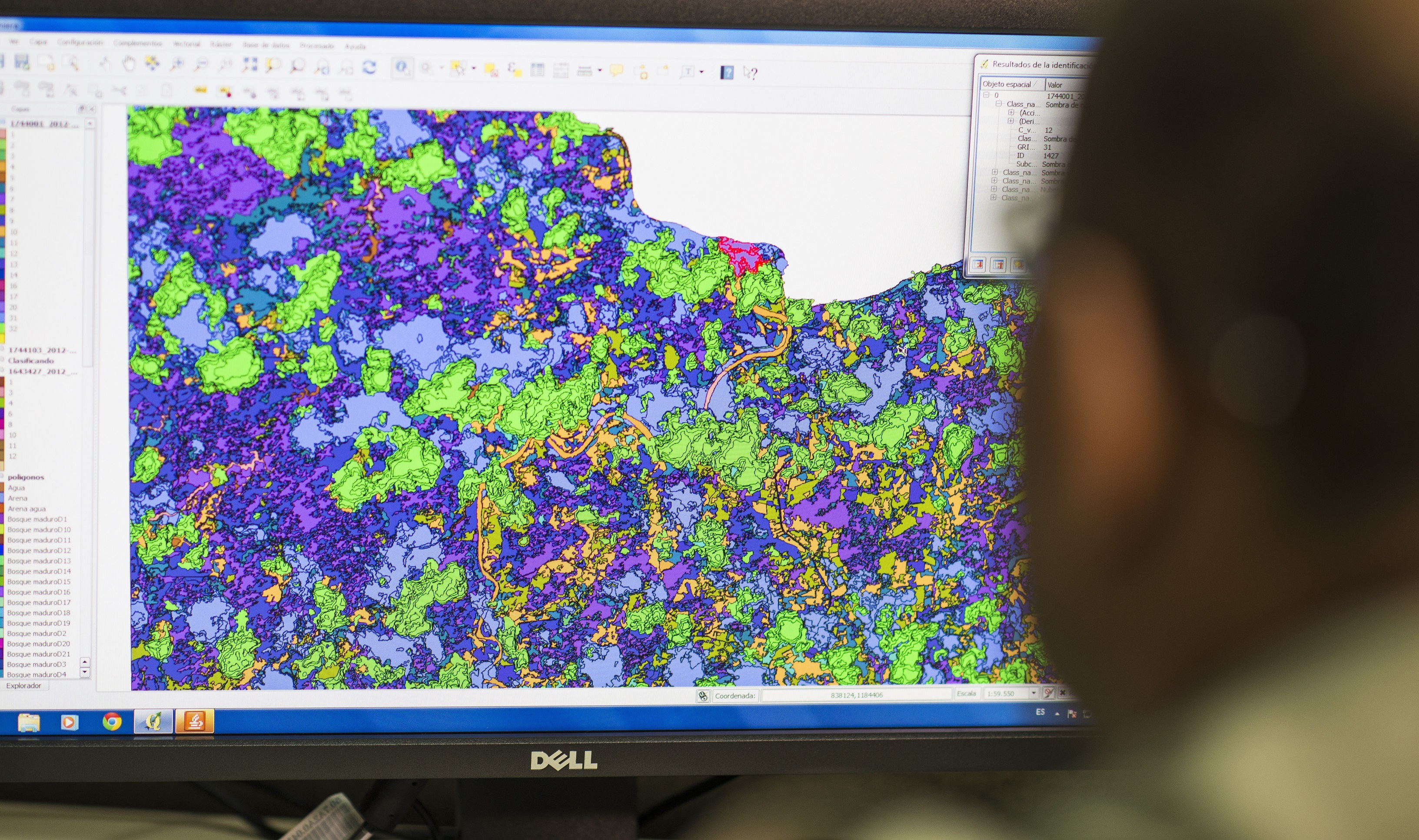
Visualization of Land Cover Map
GIZ
With the United Nations Decade of Restoration, countries have set a goal of conserving at least 30% of our soils and water by 2030; this requires a robust and transparent monitoring system to measure how many hectares have been restored and how they have improved ecosystem services.
This solution proposes a way to measure and evaluate ecosystem services at the landscape level, including: identification of potential restoration areas, development of suitability indices for restoration measures, measurement of improved carbon sequestration, erosion reduction, improved connectivity and water infiltration; through the application of remote sensing and geospatial analysis.
The solution proposes the following method: 1) Generation of a Baseline and Suitability Indices, 2) Elaboration of a Geographic Database of Management Units; and, 3) Generation of an Impact Line.
Last update: 30 Sep 2025
1440 Views
Photo and video gallery
Context
Challenges addressed
- The acquisition and homologation of reliable geo-spatial data.
- The development of spatio-temporal modeling of ecosystem services with data that presents different variables, scales, technical criteria and legal aspects that impact land use.
- Generate a technical-pedagogical product that would be cost-effective for both governmental institutions at the national level, as well as community organizations with local restoration projects.
Location
Department of Santa Rosa, Guatemala
Department of Jutiapa, Guatemala
Department of Escuintla, Guatemala
Department of Ahuachapán, El Salvador
Department of La Paz, El Salvador
Department of Cortés, Honduras
Department of Río San Juan, Nicaragua
Province of Alajuela, Costa Rica
Province of San José, Costa Rica
Province of Veraguas, Panama
Province of Los Santos, Panama
Azua Province, Dominican Republic
Province of San Juan, Dominican Republic
Central America
Process
Summary of the process
The baseline survey of ecosystem services and the development of restoration suitability maps (B1) provide information on the current state of ecosystem services in a territory, while identifying the most suitable sites for implementing specific restoration techniques in the selected landscape.
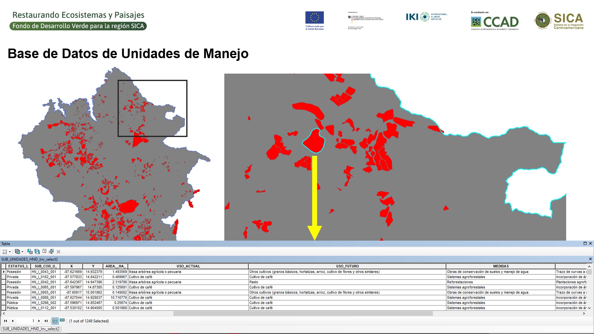
While B1 identifies potential restoration sites, the areas that are selected by project implementers allow the creation of a management unit database (B2).
B2 compiles and systematizes the most relevant field information of the management units such as their current use, their future use and the restoration techniques applied in the management units.
Finally, an impact line is elaborated, based on B1 and B2, where the effectiveness of the selected restoration measures and their direct and indirect impact on the landscape is measured.
Building Blocks
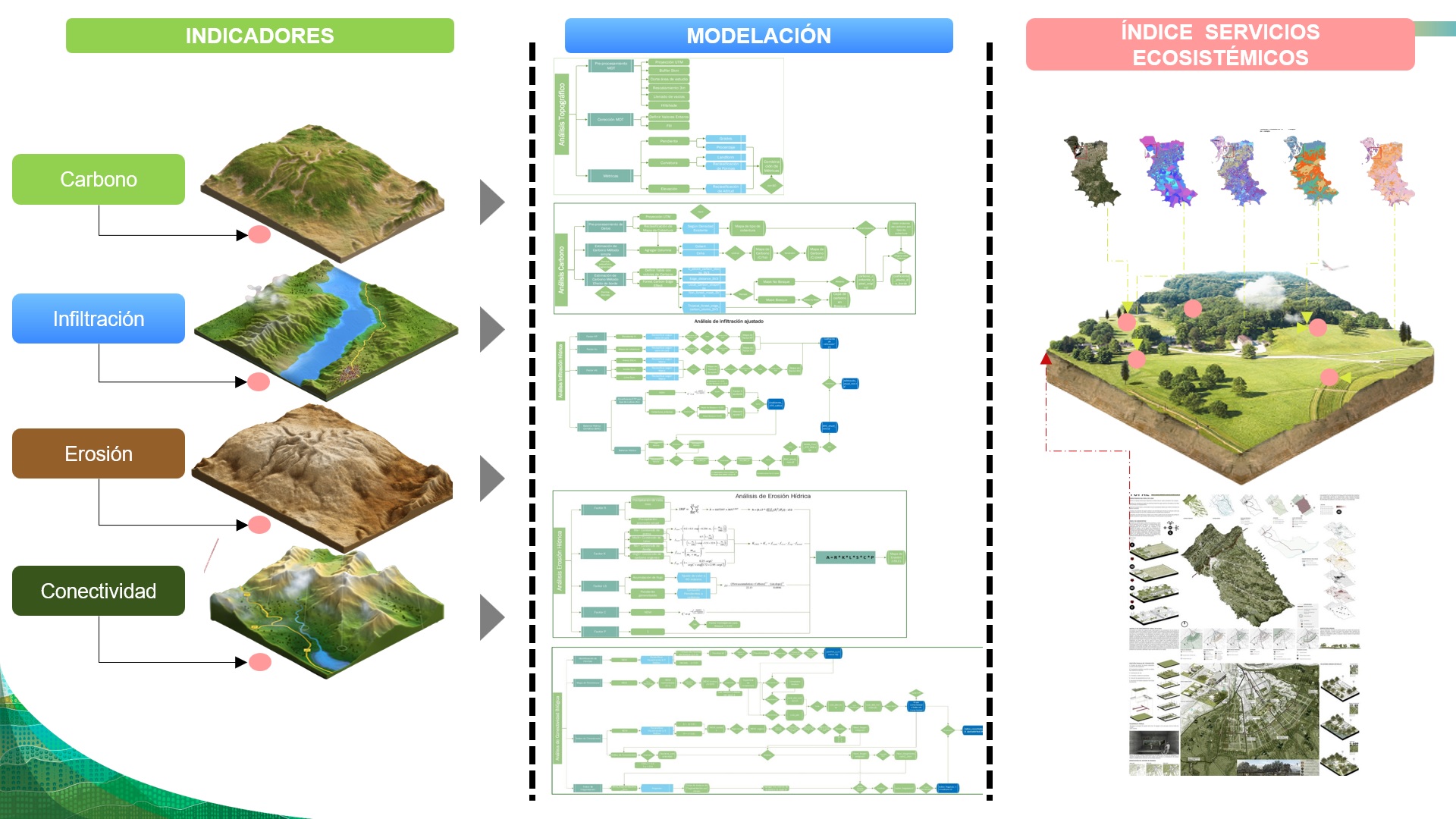
Ecosystem Services Baseline Construction
The objective of this building block is to provide developers and implementers of ecosystem and landscape restoration projects with a tool that uses remote sensing and geospatial data to determine the current state of ecosystem services and the sites where specific restoration measures can be implemented.
The steps to execute it are as follows:
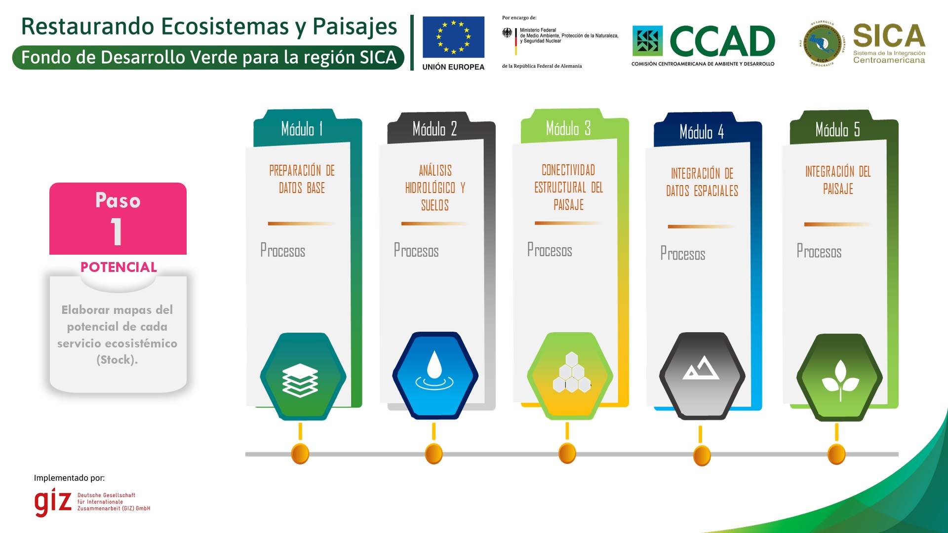
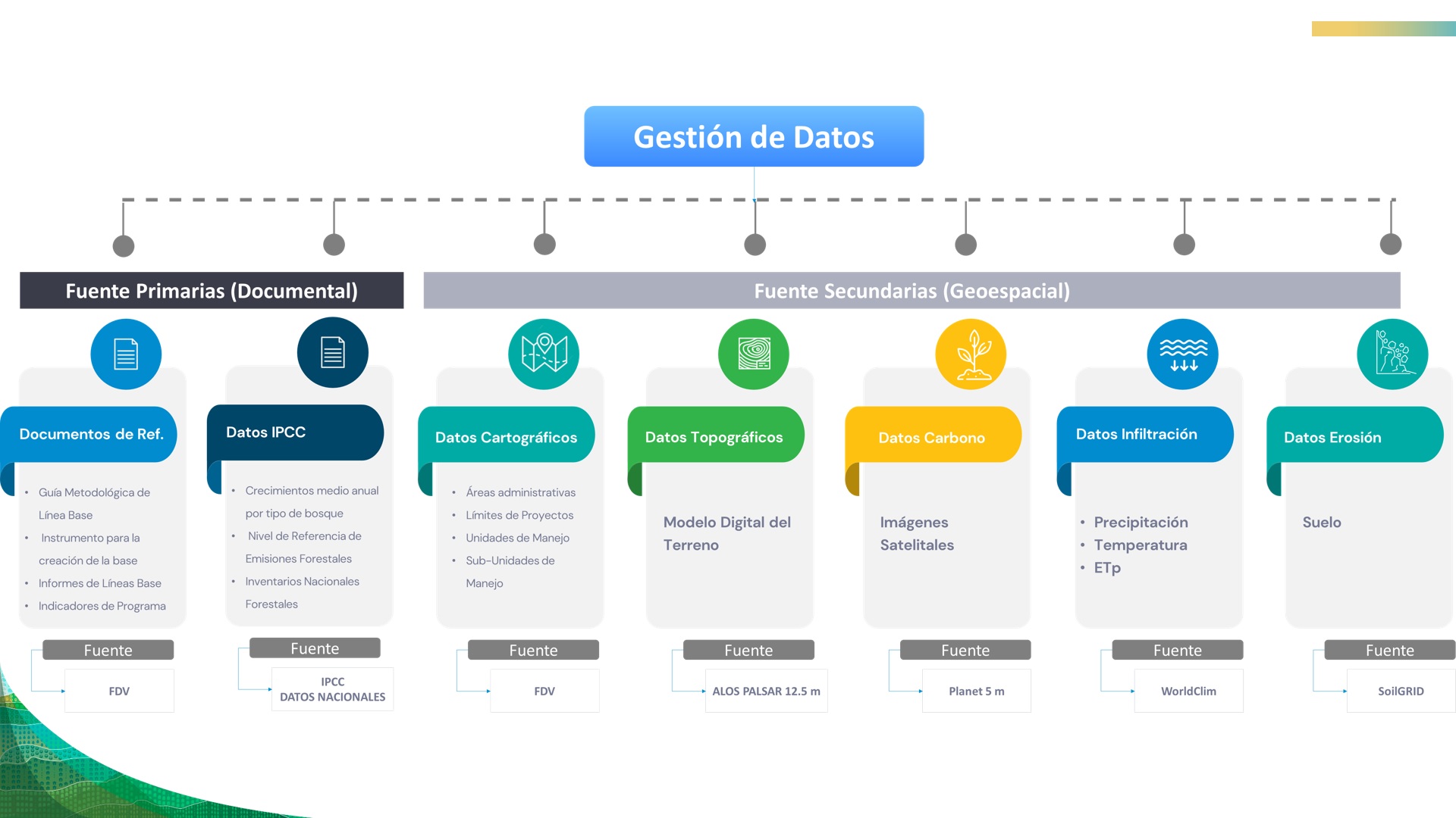
- Preparation of baseline data: it forms a cartographic series that includes information on the project area, topography, climate, soil and forest cover.
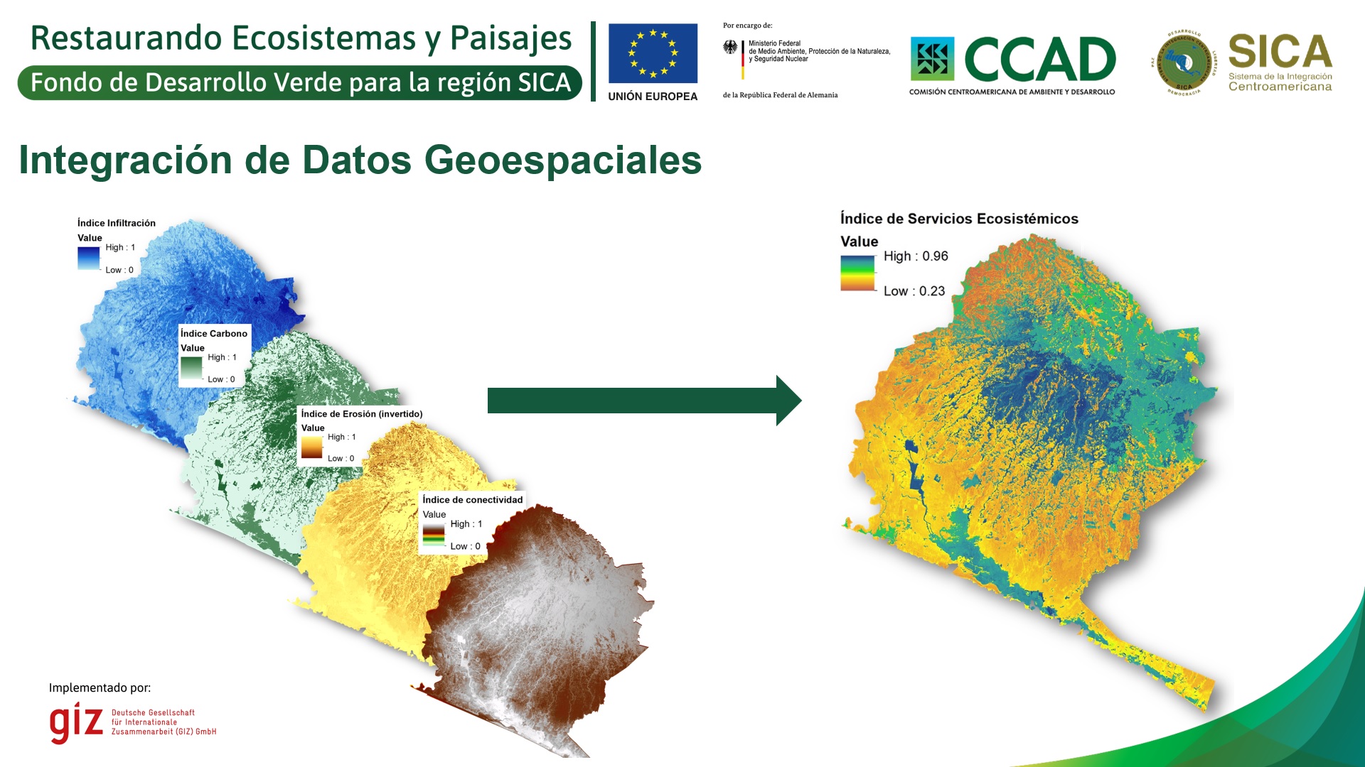
- Hydrological and soil analysis: results in the water erosion map and the water infiltration map of the project area.
- Structural landscape analysis: results in the biological connectivity map of the project area.
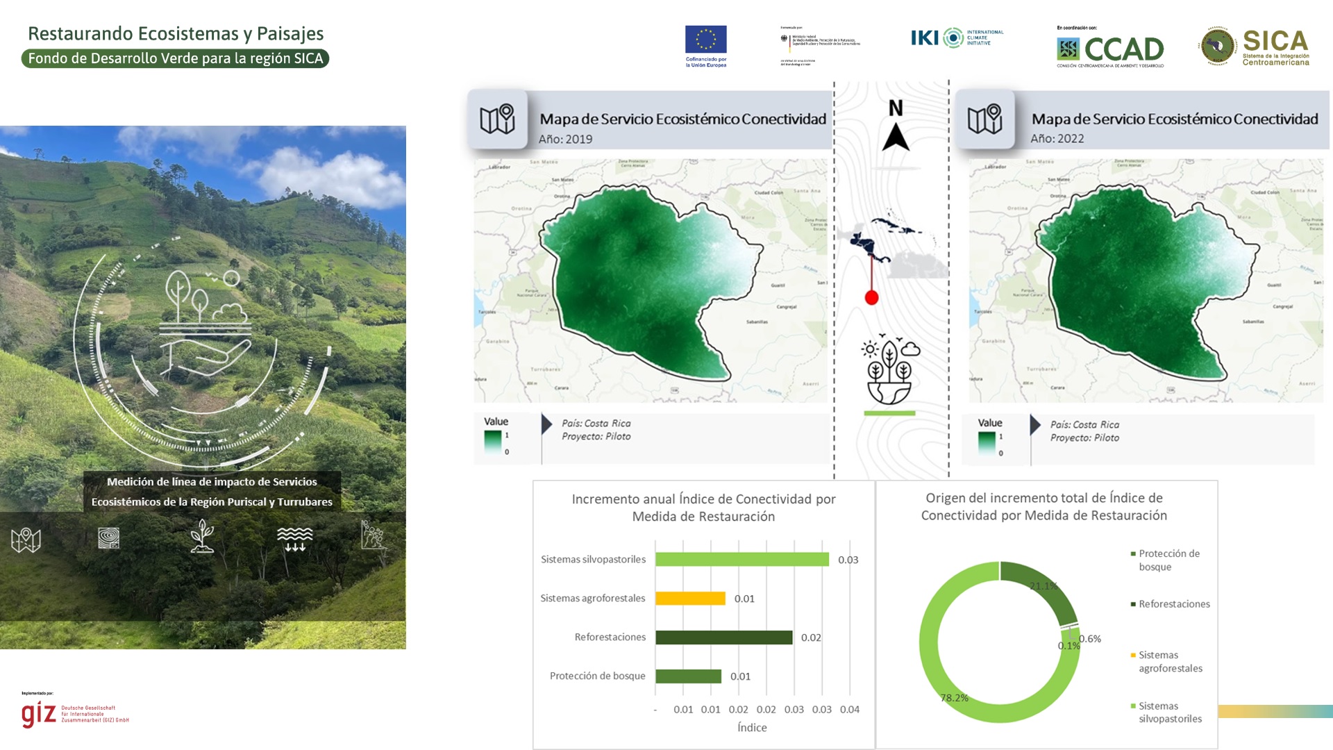
- Integrated landscape analysis: results in the ecosystem services index and its map in different territorial management units.
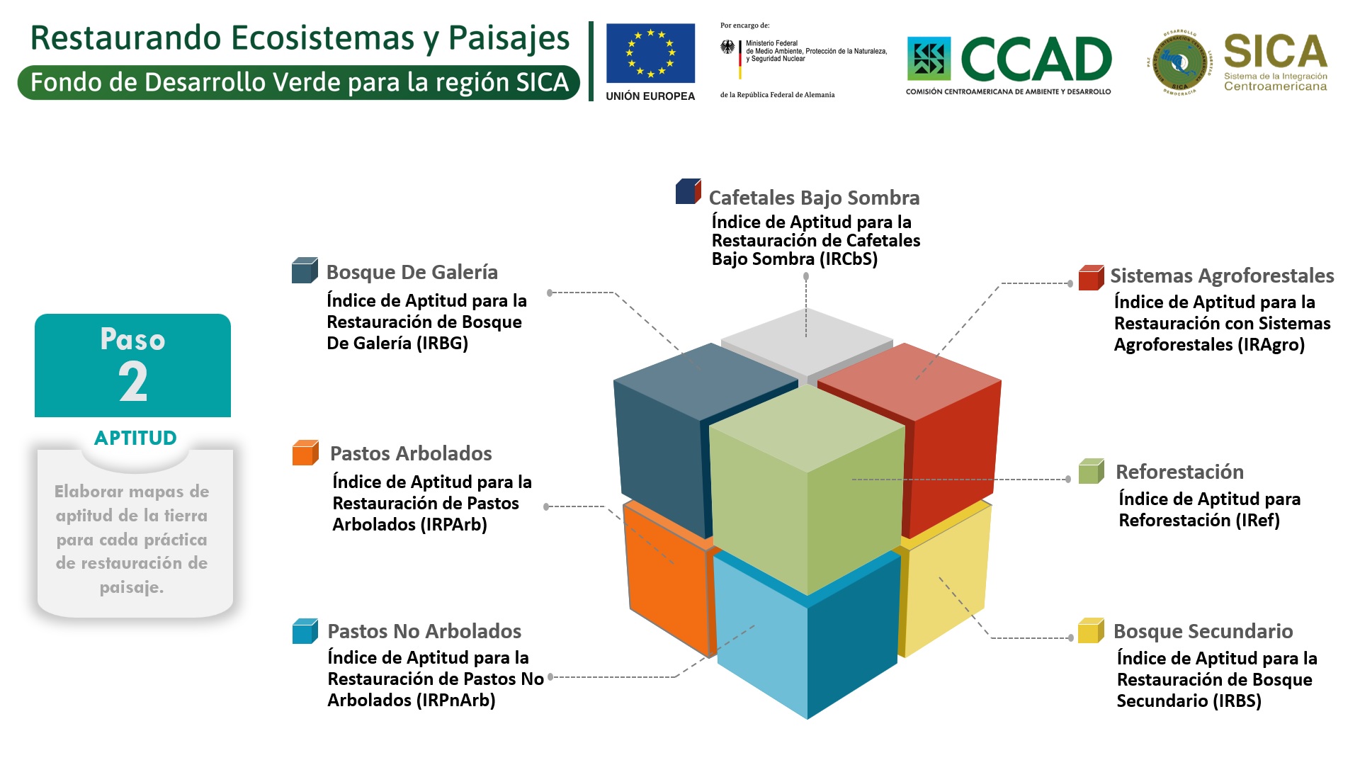
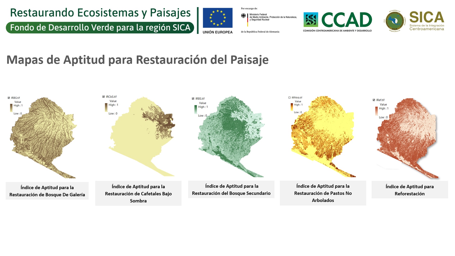
- Generation of suitability indexes: results in 7 soil suitability maps to apply specific ecosystem and landscape restoration measures.
Enabling factors
- Have access to official geospatial information sources.
- Implement a training and capacity building process, where doubts and uncertainties about methodological aspects and technologies to be used are resolved, which facilitates their adoption.
- Have an advisor or mentor during the process; this facilitates the resolution of doubts or queries arising from the execution of the instruments; a single process of accompaniment is sufficient, as it develops a strong foundation for future replications.
Lesson learned
- It requires a technician with basic knowledge of GIS, since it requires access and manipulation of tools, data and platforms very specific to this sector.
- The execution of the process is not time consuming, however, it requires time and exclusivity to perform it (more, if it is the first time it is executed); which are reduced with each new replication process.
Elaboration of a Database on Restoration Measures
The objective of this building block is to provide developers and implementers of ecosystem and landscape restoration projects with a tool for collecting key information in the field to measure the impact of proposed restoration actions.
The steps for its implementation are:
- Survey of management units: provides complete information on the sites selected for restoration actions and includes; name and sex of the producer, correlative number and code of the management unit, administrative boundaries, geographic coordinates, area and legal status of the management unit, predominant land use and a photograph of the site.
- Survey of the management subunits: provides complete information on the specific restoration measures to be implemented in the selected sites and includes; the codes of the management subunits, coordinates and areas of the management subunits, current land use, future land use, restoration measures and practices to be implemented.
By executing this process, information is available that relates restoration actions to the improvement of ecosystem services in different parts of the landscape.
Enabling factors
- Incorporate new technologies and work distribution schemes to make field data collection and processing cost-effective.
- Develop communication and performance protocols between office and field teams to collect quality data.
- Have a supervision scheme that provides timely feedback to data collection and processing, while avoiding reprocessing.
Lesson learned
- The process of collecting management units is the most time-consuming part of this solution (estimated to be 2% of the project's execution cost), and therefore requires detailed and precise planning of the technologies to be used, the number of personnel required and the ways in which the data will be processed, as failure to do so in an appropriate manner may increase costs.
- To take care of the processing and quality of the data, cross supervisions (internal personnel of the organization that is not linked to the project) or outsourced (external personnel that have been hired for this purpose) are required, which can identify inconsistencies in the databases and what has been executed in the field.
Measuring the Impacts on Ecosystem Services
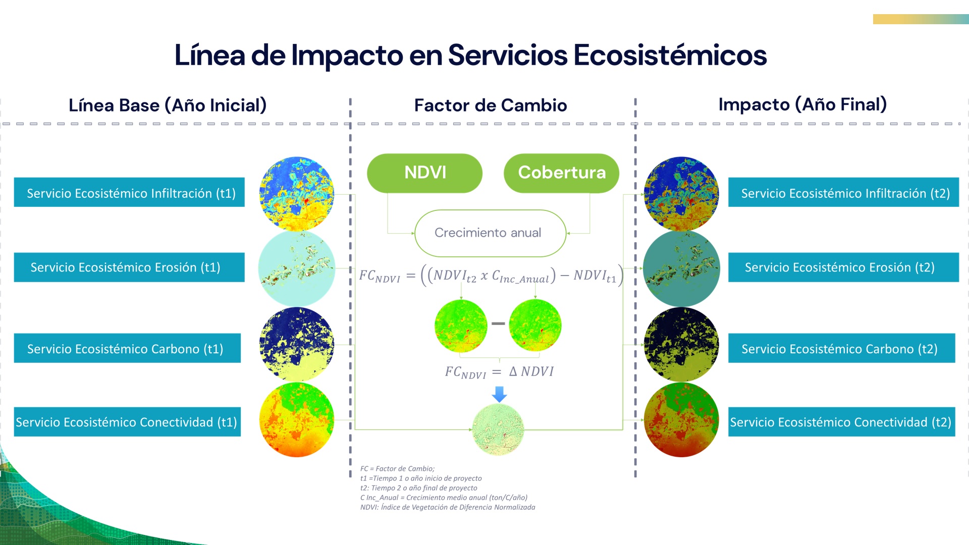
The objective of this building block is to provide developers and implementers of ecosystem and landscape restoration projects with a tool that uses remote sensing, augmentation factors, and the integration of the two as a way to evaluate the effectiveness of restoration interventions on the ground.
To evaluate the line of impact of ecosystem services based on remote sensing, baseline data (baseline, management units and recent images) are collected and the differential between the initial and final year is calculated through: the definition of the increment tables, the normalization and adjustment of images, and the modeling of ecosystem services.
The increment factor approach is used for cropland and/or livestock where spectral indices derived from satellite imagery fail to accurately detect vegetation changes; and is calculated through: definition of baseline data, categorization of restoration practices and estimation of increment factors per implemented measure.
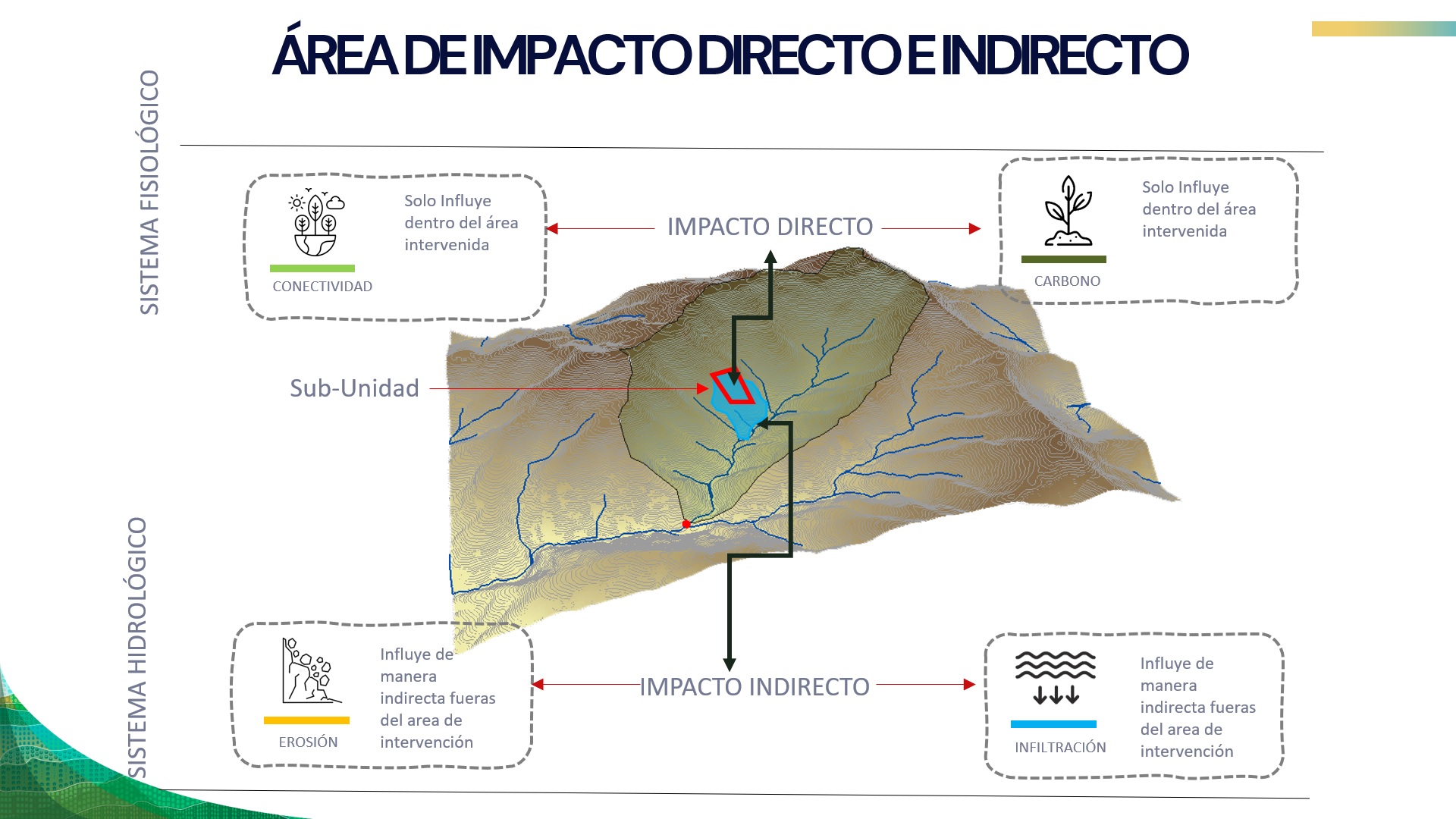
By executing this process, the area directly and indirectly impacted is available.
Enabling factors
- Have a baseline with the same variables and geospatial models to make credible and reliable comparisons over time.
- Have a database of management units that clearly reflects the restoration actions that were executed in the field.
- Implement a training and capacity building process with an assigned advisor, where doubts and uncertainties about methodological aspects and technologies to be used are resolved, which facilitates their adoption.
Lesson learned
- The databases that include the restoration measures in the territories should be reliable and preferably have been verified through supervision and control of data in the field.
- If the developers and executors of restoration projects implement these methods in different areas, it is important to homogenize the variables, their treatment and the scale at which they execute them.
Impacts
The implementation of 14 landscape restoration projects in the 8 countries of Central America and the Dominican Republic yielded the following results:
- Implementation of restoration measures in 58,640 ha. impacting on the improvement of ecosystem services of 138,539 ha.
- Improvement of ecosystem services with respect to the baseline; an increase in carbon sequestration 8.47 tonC/ha (24.05%), increase in water infiltration of 42.64 mm/ha (9.71%), reduction of erosion -4.51 ton/ha (20.69%) and increase in the connectivity index 0.012 (7.8%).
Beneficiaries
Government institutions, civil society organizations, forest communities, indigenous peoples and individual professionals who design, implement and/or evaluate ecosystem and landscape restoration projects.
Story

Carmen Cordero
UTEPDA
"With this program our team was strengthened through all the training we have received both nationally and internationally; this will allow us to have a baseline through an algorithm to evaluate how the intervention area was before the project; with the use of different satellite tools we will be able to calculate quantitatively what have been the different indicators and then know how the indicators have risen, how erosion has decreased, among others". Carmen Cordero, Operations Manager of UTEPDA.
Connect with contributors


Other contributors
Emma Flores
Deutsche Gesellschaft für Internationale Zusammenarbeit (GIZ) GmbH
Estuardo Fuentes
National Forest Institute (INAB)
Randall Herrera
FONAFIFO
Roney Samaniego
Ministry of Environment of Panama
Efrain Duarte
Analítica Consultants
Fabio Casco
Analítica Consultants
Claudia Garrido
Analítica Consultants