Promotion of farmer experimentation

INIFAP technicians and other organizations have accompanied Apaseo el Grande producers for many years, training them and encouraging them to seek their own solutions to the particular problems of their plots.

Over time, the growers learned that their plots have particular needs depending on their location, soil type, climate conditions, among other things, and that the "recipes" they sometimes find in books do not always work the same for everyone. This motivated them to continue experimenting with different practices within the five axes of sustainability they had learned, and to write down the combinations that gave them better production yields at lower cost. This has been at the heart of the AESAC experience.

They also learned to share their experiences and give recommendations to other producers who were resistant to change, and were able to organize training workshops even in other communities.

  • The good relationship of the producers with the technicians who accompany them, together with their openness to allow them to seek their own solutions instead of pigeonholing them into orthodoxy.
  • The courage of the producers to try methods not previously known to them, at the risk of reducing their profits when the results were not as expected.
  • The demonstration that the method works: in a year of severe drought, AESAC members obtained higher yields than their neighbors, which soon attracted more interested producers.
  • Being able to demonstrate that everyone has much to contribute to the process of sustainable axes gives a great value of self-esteem to AESAC producers.
  • It is important to understand that environmental conditions, soils and management are very different among all producers, which results in different production data.
Strengthening of social organization

The group of producers interested in continuing to implement the sustainable production practices they had learned, sought to organize themselves in a more formal way, understanding that together they could access more support and have their own personality before different institutions.

With support from GIZ, they formed a Civil Association called Agricultores en Ejes Sustentables A.C. (AESAC), which is an organization run entirely by the producers of Apaseo el Grande. In addition to the development and consolidation of the producers' technical capacities, AESAC contemplates the development of administrative and management capacities. This action seeks to generate in the producers the necessary managerial skills to achieve efficient administration, as well as the skills to achieve financial sustainability of the organization and future access to public and private resources to continue and improve the production model for the benefit of the producers and biodiversity.

  • There was an awareness and interest in the group of producers to formalize their efforts in an organization that could obtain financing.
  • The formalization of the Association allowed its registration with the Treasury office and this made it possible to obtain a bank account.
  • The training and constant advice from the GIZ management team was indispensable to advance the project, both for the acquisition of goods and for the verification of expenses.
  • It is always necessary for AESAC's partners to contribute resources and manpower to make the most of the support they receive.
  • These types of projects are long term and few governments and institutions are willing to participate, so it is the interest of the partners that keeps the work going.
  • The partners have learned to recognize their mistakes and to face the challenges of creating a grassroots organization. This is not the case in many farming communities.
Technical Support

In 2013, the National System of Phytogenetic Resources for Food and Agriculture (SINAREFI) together with the National Institute of Forestry, Agricultural and Livestock Research (INIFAP) initiated a monthly training program for small producers in the community of Ojo Zarco, in the Municipality of Apaseo el Grande, Guanajuato. A community seed bank was organized and a group of producers who are custodians of criollo corn seeds was formed.

Initially, many producers attended the training sessions in the hope of receiving economic support, but when Dr. Aguirre of INIFAP proposed that each producer conduct experiments to learn about the best conditions for his plot, a group of the most interested producers in the area began to consolidate. The experiments compared the "traditional" sowing with the one that applied a change of practice, with respect to data on grain production and shearing. The results in the color and size of the plants encouraged the producers, but the results in productivity were decisive.

The training process is very slow but effective in the semiarid rainfed agriculture zone. It takes 6 to 7 years to obtain good results when only small farmers have their own resources.
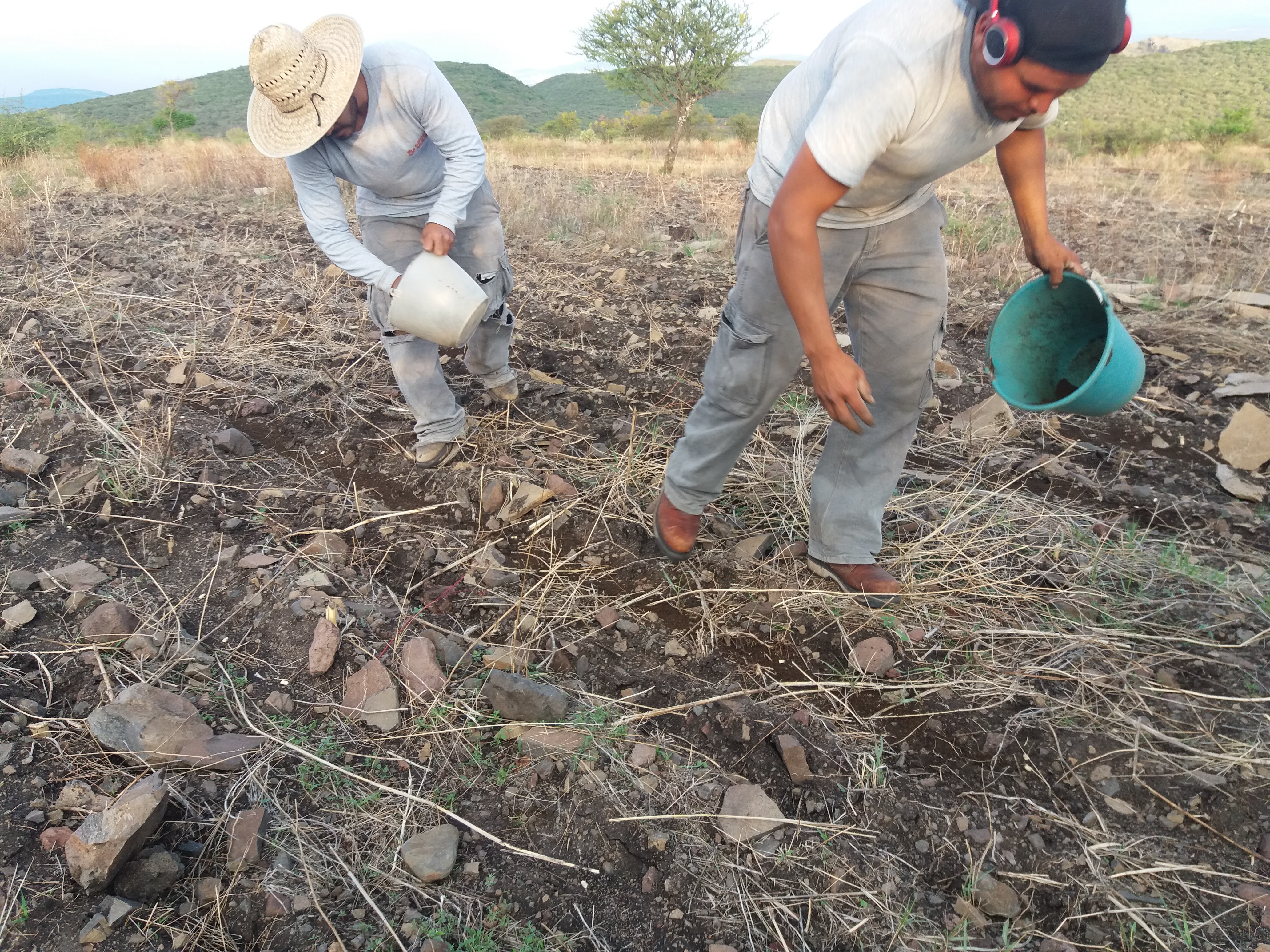
  • The training program carried out by SINAREFI and INIFAP allowed producers to understand the importance of the 5 Axes. Although the program did not last more than 3 years, the producers were able to continue replicating the good practices learned.
  • The associative capacity of small producers and their ability to experiment on their own plots.
  • The involvement of young people from the community in monitoring actions.
  • The use of digital tools has been fundamental for the good implementation of cooperative projects, but even more so for not stopping activities during the pandemic period.
  • The continuous technical accompaniment of INIFAP personnel gave a very important support to the development of the 5 axes of sustainability that now make up the production model adopted by the producers of Apaseo el Grande.
Articulación con las comunidades nativas y campesinas y autoridades del ámbito

Las comunidades nativas y campesinas que se localizan en el ámbito de la RNM son aliados y participan en las actividades de vigilancia al interior de la RNM, en la zona de amortiguamiento y en el paisaje asociado a la RNM que utiliza cada comunidad. La información generada permite que se planteen estrategias conjuntas de acción para la protección de los ecosistemas o su uso sostenible por las comunidades y esta información a su vez es compartida con las autoridades para convocar, de acuerdo con sus competencias, su acción frente a la amenaza.

Ha sido importante el relacionamiento positivo con las comunidades del paisaje asociado que ha permitido un cambio de posición de las comunidades y un mejor enlace con las autoridades del entorno para con los objetivos de la RNM y esto hace que el trabajo de respuesta a las amenazas sea más articulado.

El trabajo articulado ha permitido fortalecer las capacidades de los comuneros que son contratados como guardaparques y de los que forman parte de los comités de vigilancia. Las informaciones sobre las amenazas son articuladas también con las autoridades que tienen competencias fuera de la RNM, para coordinar acciones hacia la conservación y aprovechamiento sostenible de los ecosistemas y recursos.

Eficiencia en resultados de la vigilancia y control con un sistema de manejo de información (Implementación del aplicativo SMART)

En la Reserva Nacional Matsés, la vigilancia y control se orientan a: a) la reducción de prácticas no sostenibles de aprovechamiento de los recursos naturales, y b) la reducción de ingresos a zonas y sectores no permitidos según la zonificación del área protegida. Para generar respuestas más rápidas y eficientes ante las amenazas se vienen utilizando el aplicativo SMART que permite hacer más eficiente la colecta y sistematización de datos recogidos durante las actividades de vigilancia y control.

La RNM ha adoptado el programa SMART (traducido al español, herramienta de recojo de información y monitoreo espacial), que permite la sistematización y organización de los datos, particularmente de las amenazas al área protegida. Antes de la adopción de SMART, los datos de los patrullajes tardaban o no llegaban a sistematizarse, quedándose en cuadernos de campo y hojas de datos, por lo que no era aprovechada y utilizada para apoyar la gestión de las ANP en forma oportuna.

La implementación del aplicativo SMART, luego del proceso de capacitación ha tenido una rápida aceptación entre el personal guardaparque y los especialistas de la RNM, debido a que es posible observar casi en tiempo real la información que es recogida en campo y esto permite una comunicación más fluida entre todo el equipo para generar respuestas a las amenazas.

Sectorización para la vigilancia y control

En base a sesiones de trabajo con el personal guardaparque, conocedores del territorio, la Reserva Nacional Matsés ha dividido su área en sectores según su vulnerabilidad a las amenazas, para implementar las acciones de vigilancia que permiten el seguimiento de amenazas actuales o potenciales. Esto ha permitido redireccionar los esfuerzos para no vigilar exclusivamente el interior de la RNM sino la zona de amortiguamiento y paisaje asociado donde se originan las amenazas.

Considerando que las amenazas no son uniformes en el espacio se propuso la sectorización en función a criterios de: a) amenazas, b) accesibilidad al área protegida, c) centros poblados, d) recursos de interés y e) zonificación. Estos criterios permiten diferenciar los sectores según la vulnerabilidad del ANP.

En el caso de la Reserva Nacional Matsés, se han identificado ocho sectores, tres de ellos tienen un nivel de vulnerabilidad bajo, ya que no se han reportado amenazas, son de difícil acceso, no existen centros poblados y la zonificación del área protegida restringe ciertos usos a pesar de la existencia de recursos de interés. Otros tres sectores, tienen un nivel de vulnerabilidad alto, se han reportado amenazas y existen centros poblados colindantes, cuentan con fácil y múltiples accesos, cuentan con recursos de interés que vienen siendo aprovechados, y la zonificación permite el uso de recursos bajo ciertos lineamientos. Finalmente, los últimos dos sectores, tienen un nivel de vulnerabilidad medio, principalmente porque si bien cuentan con amenazas y centros poblados cercanos al área protegida, además del aprovechamiento de recursos, la accesibilidad es limitada.

Wayfinding and interpretation of cultural and natural heritage

The system of signage in place within the Greenway relies on the concept of “wayfinding”, an approach that seeks to organise spaces in order for users to navigate them easily. Within the Greenway, wayfinding has been pivotal to maximise the experience of visitors and enhance their relation to the site. The approach has also been sided by the installation of physical signage guided by the adoption of a Master Plan (2016) and the visibility given by the creation of a website, the development of a guidebook in four languages that also incorporates the EnjoyRespectFlorence campaign, the organisation of guided visits, and the release of videos and flyers. The interpretation of the itineraries is made accessible also thanks to the restoration of their physical attributes such as the ramps, the requalification of new components such as the Forte Belvedere, and the production of historical descriptions inserted in the signage system. Finally, the establishment of a Firenze Greenway Lab gathers students, graduates and professionals working together for the urban and environmental planning of the project.

The installation of signage for interpretation and wayfinding was made possible through the formalisation of the Master Plan following the establishment of interinstitutional partnerships and the availability of financial support provided by the CRF Foundation.Additionally, the principles of the Lille Declaration (2000) guided the efforts for the institutionalisation and composition of the Greenway; and finally the communication strategies and the website enhanced and broadened the accessibility of information and signage.

Thanks to these initiatives, the understanding of the three itineraries composing the Greenway has been enhanced and disseminated to the wider public. The importance of both the physical signage and the virtual information was highlighted thanks to the website provided in Italian and English and the production of ad hoc guidebooks in different languages. Planning the itineraries and the related signage system also opens new avenues for the inclusion of additional components enriching the itineraries, which are therefore exposed to positive works of restoration and requalification. A case in point is the Forte del Belvedere, a fortress that benefited from a change of ownership: as a public good, the building is now open to the public, adding value to the project and constituting one of the main attractions of the Greenway. Finally, the COVID-19 pandemic has highlighted the importance of these green urban spaces for the well-being of residents and city users, with its significance adequately communicated on virtual platforms. 

‘Promenadologie’ as a philosophy to experience heritage places in alternative ways

The implementation of principles related to slow tourism and the creation of three urban green itineraries (one focused on the Medici town, one on the medieval components, one on the hills and surrounding environment) has also been connected to the concept of ‘Promenadologie’, the science of strolling, a philosophy to enhance environmental perceptions and experiences through walking. In the case of the Greenway, the ‘Promenadologie’ constitutes an alternative way to experience the connection between the two World Heritage sites, as well as the relations between natural and cultural elements, only by foot or bike. The walk becomes a powerful tool to reflect upon the aesthetic and sensorial qualities of heritage and nature, bridging the gap between visitors and the surrounding environment.

The enjoyment of natural and cultural elements by foot and bike, and specifically through strolls, is made possible thanks to the creation of ad hoc itineraries connecting selected gardens and green areas already known for their aesthetic features. The itineraries connect the Bardini, Boboli and Bobolino gardens, passing through the hills of the Oltrarno district and the Villa di Poggio Imperiale. The walk is further enhanced by the lack of pollution and traffic, placing the well-being of visitors at the core of the project.

The establishment of connections between World Heritage properties, urban and historic gardens, and lesser known neighbourhoods by means of a walking itinerary has proved to be a successful strategy to encourage sustainable and unique journeys. The science of strolling (Promenadologie) allows for the encouragement of slow and green tourism, the economic and sustainable development of different parts of the city outside of the city centre, and the well-being of users, who are not affected by traffic jams or noise and air pollution. Moreover, the itineraries promote a new way to experience the city without being over-stimulated by sensorial inputs, activities and information in the historic centre, fostering a simpler and internal reflection on the dualism of man/nature.

Creation of inter-institutional partnerships between authorities, stakeholders and World Heritage sites

Greenway Florence is characterised by the successful coordination of research bodies, the Municipality of Florence, private stakeholders, and heritage institutions, which have formalised an inter-institutional partnership in order to manage, maintain and promote the project. The partners involved include “Firenze Greenway” Association, Fondazione Parchi Monumentali Bardini e Peyron, HeRe Lab - Heritage Research, the Municipality of Florence (Tourism Department, Directorate for Economic Activities and Tourism, Directorate of Culture and Sport, Department and Directorate of the Environment, ‘Florence World Heritage and relations with UNESCO’ Office), Fondazione CR Firenze, and the Uffizi Gallery.

The governance system and the partnerships between stakeholders are to be formalised by a Memorandum of Understanding and integrated ticketing system, as well as an itinerary through the gardens belonging to various institutions: the Bardini Garden (Fondazione CR Firenze), the Boboli Gardens (Uffizi Gallery) and the Bobolino Garden (Municipality of Florence).

The Greenway is a successful project that brings together different private and public institutions through a planned Memorandum of Understanding and an integrated ticket. The involvement of all parties and stakeholders has ensured that the itineraries include all the natural and cultural components constituting the itineraries.

‘Urban countryside’: an approach to connect nature and culture

The concept of urban countryside is becoming pivotal in recent years as a way to overcome the traditional dualism between city and countryside, encouraging holistic approaches. The creation of itineraries connecting urban green areas, the Historic Centre of Florence and the Medici Villas constitutes a successful approach to experience urban centres in a sustainable way and connect Core and Buffer Zone of the two World Heritage sites. The ‘urban countryside’ has become a solution to address the need for more green spaces within cities, while at the same time placing the well-being of visitors at its core.    


In addition to the establishment and creation of physical itineraries, the enjoyment of the urban countryside and the valorisation of urban green areas is made possible through requalification actions (i.e. the restoration of the ramps through funds provided by the CRF Foundation in 2018). Such initiatives aim at enhancing the significance of neighbourhoods not included in traditional itineraries through the restoration and maintenance of physical components, the installation of signage, as well as a range of research and promotional activities.

The inclusion of green urban areas in heritage processes and cultural services is a practice that allows for a holistic understanding and enjoyment of urban spaces. Cities are now being regarded not only as an ensemble of built components, but also as the interrelation between nature and men. The well-being of residents can therefore be enhanced through the provision and valorisation of green spaces, enabling them to enjoy alternative, sustainable, and eco-friendly experiences.