Nature-Based Riverbank Stabilization for Wildlife and Community Safety

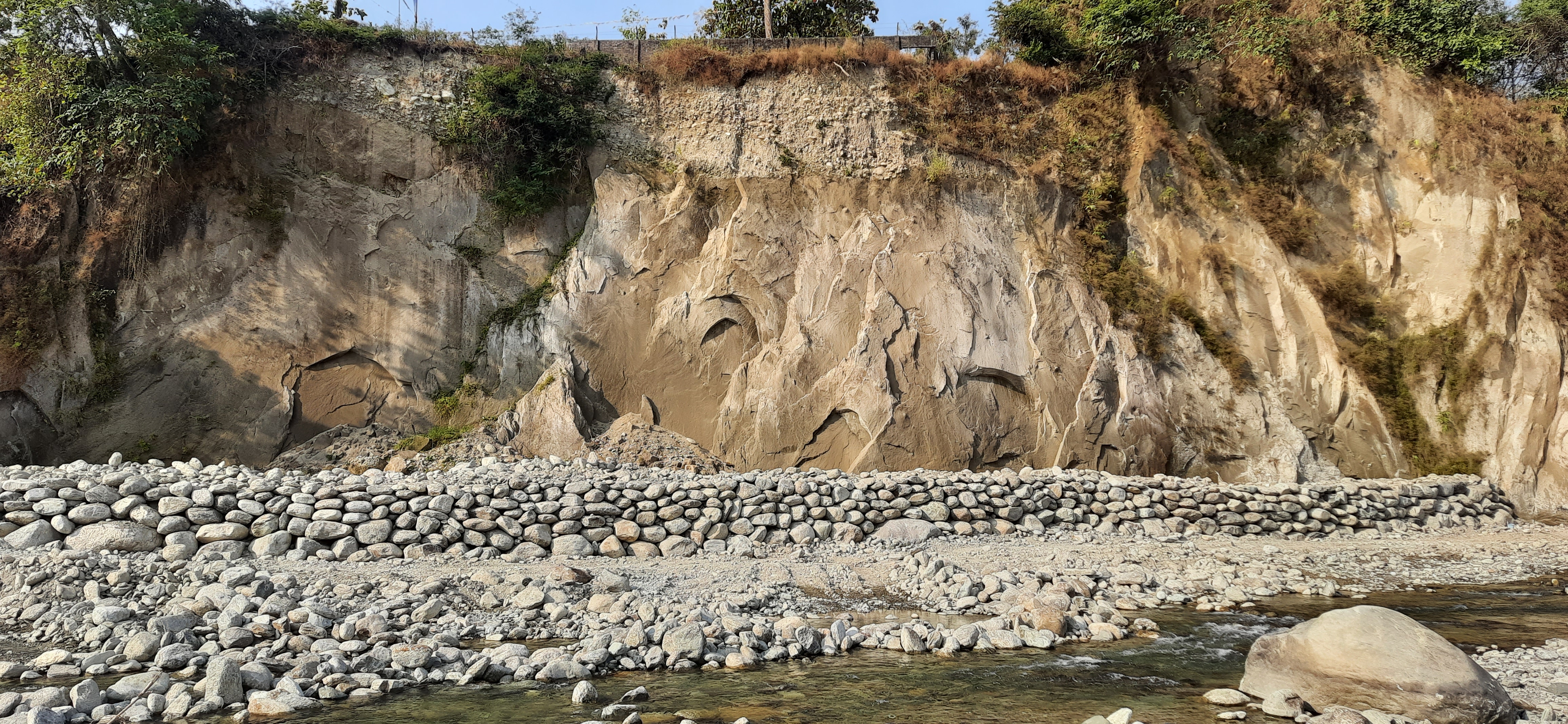
This building block focuses on using nature-based solutions to stabilize riverbanks and protect both wildlife habitat and community infrastructure. Riverbank erosion poses significant threats to riparian vegetation, drinking water sources, agricultural fields, and wildlife movement corridors. Instead of relying on concrete structures, this approach applies eco-friendly techniques such as bioengineering, bamboo and brush layering, use of coir logs, and planting native grasses, shrubs, and tree species to strengthen soil structure naturally.
Stabilizing riverbanks with vegetation reduces erosion, slows surface runoff, filters sediments, and restores natural river dynamics that support fish, amphibians, and terrestrial wildlife. These methods also improve habitat connectivity, helping animals move safely between feeding areas, mineral licks, and water sources.
Community participation is essential: local residents assist in planting, maintaining vegetation, monitoring erosion, and protecting newly restored areas from grazing and disturbance. This increases ownership and ensures long-term sustainability.
Nature-based riverbank stabilization also builds climate resilience by reducing flood impacts, preventing land loss, and lowering long-term maintenance costs. Integrated with watershed management, it becomes a key strategy for landscape-level conservation and community safety.

  • Access to native plant species for bioengineering and restoration.
  • Community labor participation during planting and maintenance.
  • Technical expertise in nature-based and bioengineering methods.
  • Supportive local administration for approvals and coordination.
  • Vegetation-based methods require consistent watering and protection until roots are well established.
  • Community involvement ensures long-term care, monitoring, and reduced disturbance.
  • Nature-based solutions work best when combined with broader watershed and catchment management.
  • High-flow or highly eroded sections may still require limited structural reinforcement.
Sustainable NWFP Marketing to Support Community Livelihoods

This building block focuses on strengthening 19 NWFP Community Groups through well-developed management plans and bylaws that ensure sustainable harvesting, monitoring, and equitable benefit-sharing. JWS is known for the sustainable collection of Rubia spp., Swertia chirayita, star anise, soft broom grass, mushrooms, and other high-value NWFPs.
Management activities include resource assessment, setting harvest quotas, training communities on proper harvesting techniques, enforcing bylaws, and supporting community-led monitoring. JWS also supports market linkages, pricing transparency, and annual reviews of the management plans.
Community participation is central: members help monitor resource conditions, report illegal extraction, follow sustainable harvest practices, and collectively manage income distribution.
In 2024, these groups collectively earned around Nu. 3.5 million from the sale of Rubia spp., Swertia chirayita, and star anise alone, excluding income from other NWFPs, demonstrating the livelihood potential of sustainably managed forest resources.

  1. Strong community institutions with approved bylaws
  2. Training on sustainable harvesting and monitoring
  3. Market access for high-value NWFPs
  4. Active patrolling support to reduce illegal extraction
  1. Clear rules and bylaws improve compliance and sustainability
  2. Community ownership increases protection and reduces overharvesting
  3. Regular resource assessments help adjust quotas and prevent depletion
  4. Strong market linkages boost community income
  5. Transparent benefit-sharing builds trust and long-term participation
Community-led Recreational Parks and Eco-tourism for Conservation Support

This building block establishes recreational spaces such as parks, nature trails, and picnic areas to provide safe and enjoyable outdoor spaces while promoting environmental awareness. Eco-tourism initiatives generate alternative income for community members through guiding, hospitality, cultural activities, and local product sales.
These facilities build public appreciation for nature, reduce pressure on sensitive wildlife habitats, and create incentives for conservation. Eco-tourism also enhances community well-being and strengthens long-term support for environmental protection.

Attractive natural features.
Community willingness to manage tourism services.
Basic infrastructure (trails, signage, resting areas).
Promotion through local networks or online platforms.

Facilities require regular maintenance for visitor satisfaction.
Low-impact design prevents habitat disturbance.
Training guides improves visitor experience and safety.
Revenue sharing must be transparent to maintain trust.

Supplementary Nutrient Support for Wild Animals through Mineral Lick Management

This building block focuses on restoring and maintaining natural mineral licks to enhance the availability of essential nutrients such as sodium, calcium, and magnesium for wild animals. Over time, mineral licks can degrade due to erosion, invasive species, sedimentation, or human disturbance. Management activities include removing invasive vegetation, reshaping the lick, stabilizing soil using natural materials, and maintaining low-disturbance zones.
Community involvement is key: they help identify degraded lick sites, report disturbances, assist in restoration, and prevent livestock from entering lick areas. Their participation improves protection, strengthens ownership, and ensures long-term sustainability.
Healthy mineral licks improve wildlife nutrition, reproductive success, bone development, and overall health. When integrated with waterhole and grassland management, mineral lick restoration provides a comprehensive habitat improvement strategy.

Community cooperation and reporting.
Seasonal timing that avoids peak wildlife use.
Support from patrolling teams.
Local labour for clearing and reshaping work.

Community involvement enhances protection and reduces disturbance.
Maintaining buffer areas increases wildlife visitation.
Erosion control is necessary to retain mineral-rich soil.
Regular monitoring helps detect degradation early.
Combining mineral licks with waterholes and grassland management results in healthier wildlife populations.

Sustainable Waterhole Management to Improve Wildlife Access to Water

This building block enhances water availability for wildlife by maintaining natural waterholes, desilting ponds, constructing small check-dams, or redirecting natural runoff to refill drying areas. Waterholes are crucial during dry seasons, supporting herbivores, carnivores, and bird species.
Improved water availability reduces long-distance wildlife movement, thereby lowering chances of conflict with nearby communities. Waterhole management also increases habitat use diversity and supports overall ecosystem productivity.
Activities include cleaning debris, strengthening embankments, and ensuring the waterhole remains accessible but safe. This block complements grassland and mineral lick restoration for effective habitat management.

Natural water sources or seasonal streams.
Technical knowledge on water retention design.
Availability of local labor for excavation and maintenance.
Protection support from patrolling teams.

Waterholes require regular desilting to remain functional.
Locating waterholes in natural depressions reduces maintenance.
Using natural materials minimizes disturbance and ensures durability.
Avoiding steep edges prevents wildlife injuries.
Long-term success improves when combined with grassland and mineral lick management.

Integrated Grassland Management to Enhance Forage and Habitat Conditions

This building block restores and maintains grasslands through selective clearing of invasive species, controlled burning (where appropriate), and sowing of palatable native grasses. Grasslands improve natural forage availability, support herbivore populations, and reduce human–wildlife conflict.
Community members contribute by helping with clearing, seed collection, and monitoring regrowth. Their participation improves ownership, reduces accidental fires, and strengthens local stewardship.
Restored grasslands reduce pressure on agricultural lands, enhance wildlife distribution, and create healthier ecosystems that complement patrolling, waterhole restoration, and mineral lick management.

Availability of native grass seeds.
Seasonal timing aligned with rainfall patterns.
Local workforce for clearing and reseeding.
Technical guidance on grazing ecology and plant succession.

Grassland restoration is most successful when invasive species are removed before seeding.
Regular monitoring prevents reinvasion and maintains forage quality.
Engaging local communities creates support for maintenance and reduces accidental burning.
Climatic conditions, especially rainfall, greatly influence establishment success.
Reseeded plots require protection for the first year to prevent grazing pressure.

Strengthened Patrolling and Quick Response Teams for Forest and Wildlife Protection

This building block enhances on-ground protection through dedicated patrolling teams and Quick Response Teams (QRTs) who respond to threats such as poaching, illegal harvesting, forest fires, and human–wildlife conflict. QRTs are trained to act quickly during emergencies, while regular foot and night patrols provide a strong deterrent against illegal activities, improving safety for wildlife and nearby communities.

Local people do not join patrols but play an important role by informing the forest office about suspicious activities, wildlife movements, or potential conflicts. This early reporting system helps the QRT mobilize quickly and strengthens community–agency collaboration.

Improved protection allows other conservation activities—such as mineral lick restoration, habitat improvement, riverbank protection, and sustainable NWFP management—to succeed. By lowering disturbance and resource extraction, ecosystems stabilize and provide a foundation for sustainable livelihoods, eco-tourism development, and long-term climate resilience. This system builds public trust, encourages responsible behavior, and promotes shared responsibility for conservation.

Reliable communication channels with local residents for timely reporting.
Well-trained patrolling teams and QRTs with knowledge of wildlife behavior and safety.
Availability of essential field equipment such as communication devices, GPS, torch, and rain gear.
Support from local leaders and gewog administration.
Clear SOPs for emergency response and patrol duties.

Timely information from local communities greatly improves the effectiveness of QRT response, even if community members do not join patrols. Building trust is essential—when people feel safe reporting, the detection of illegal activities increases.

Challenges include difficult terrain, limited staff, and weather constraints. Continuous training and proper equipment improve response time and safety. Regular engagement with communities helps maintain information flow and reduces conflict cases.

A major lesson is that protection must be integrated with education and habitat restoration efforts. Patrolling alone cannot reduce threats unless supported by awareness and community cooperation. Recognizing community informants and maintaining open communication improves long-term collaboration.
Training on use of the data collection technology

Forestry officials provided hands-on training to Wildlife Conservation Committee members on the use of the NoteCam data collection app. Training was delivered in the local language, ensuring all participants fully understood the procedures. In addition to technical guidance on data collection, members were educated on the importance of wildlife conservation and trained to recognize key signs of wildlife presence, equipping them with both the skills and knowledge needed for effective community-led monitoring.

  • Local language instruction: Delivering training in the local language ensured that all participants fully understood the procedures and concepts.
  • Hands-on, practical approach: Direct, experiential training on the NoteCam app helped members gain confidence in data collection.
  • Integration of conservation knowledge: Combining technical training with education on wildlife importance and signs of wildlife presence enhanced understanding and motivation.
  • Support from forestry officials: Active involvement of officials provided guidance, credibility, and ongoing support to community volunteers.
  • Accessible to diverse education levels: The training was designed to be inclusive, accommodating members with varied educational backgrounds.
  • Language and clarity matter: Training in the participants’ local language ensures comprehension and increases engagement.
  • Practical, hands-on training is most effective: Members learn faster and retain skills better when they actively use the tools during training.
  • Combining technical and conservation knowledge builds motivation: Understanding the purpose behind data collection encourages consistent participation.
  • Ongoing support strengthens outcomes: Continuous guidance from forestry officials helps maintain data quality and volunteer confidence.
  • Inclusivity ensures broader community engagement: Tailoring training to different education levels maximizes participation and sustainability.
Technology used for data collection

The data collection approach is designed to be simple and accessible, accommodating the diverse educational backgrounds of Wildlife Conservation Committee members. The mobile application NoteCam is used for recording observations. This user-friendly app allows members to capture essential wildlife data—including GPS coordinates and altitude—simply by taking photos, making the monitoring process both efficient and reliable, even for those with limited technical experience.


  • User-friendly technology: The NoteCam mobile app is simple and intuitive, allowing members with diverse educational backgrounds to collect accurate wildlife data easily.
  • Automated data capture: The app records essential information such as GPS coordinates and altitude automatically when photos are taken, reducing errors and simplifying reporting.
  • Adapted to community needs: The simplicity and accessibility of the tool ensure that even volunteers with limited technical skills can participate effectively.
  • Supports timely and reliable monitoring: By making data collection straightforward, the app encourages consistent participation and ensures high-quality information for conservation management.


  • Simplicity drives participation: Tools that are easy to use encourage consistent engagement, even among volunteers with limited technical skills or formal education.
  • Automated features improve data quality: Capturing GPS coordinates and altitude automatically reduces errors and ensures accurate, standardized data collection.
  • Tailoring technology to local contexts is key: Designing the app for practical, everyday use in forest communities increases adoption and long-term sustainability.


Group Formation

The Wildlife Conservation Committee is formed entirely voluntarily, with members joining out of personal interest rather than financial gain. Voluntary participation ensures genuine motivation and yields more reliable data, whereas forced involvement could compromise the quality of the collected information. Most members are local residents who live close to the forest and are therefore well placed to observe wildlife and detect signs of poaching. However, the committee remains open to anyone interested, ensuring an inclusive and community-driven approach to monitoring.

Enabling Factors

  • Strong community interest and willingness to participate: The voluntary nature of the committee ensures members are genuinely motivated, resulting in more accurate and reliable wildlife observations.
  • Proximity of members to forest areas: Most volunteers live near or within forest landscapes, giving them frequent opportunities to observe wildlife and detect signs of illegal activities.
  • Inclusiveness and openness to all community members: Although many participants are herders or farmers, the committee is open to anyone who wishes to contribute, encouraging broader community involvement.
  • Trust and collaboration between community and forestry officials: The established communication channels, such as the dedicated WhatsApp group, strengthen cooperation and encourage active reporting.

Lessons Learned

  • Voluntary participation leads to higher-quality data: Members who join out of personal motivation are more committed and provide more accurate and consistent observations than those recruited through pressure or obligation.
  • Local communities are the most effective eyes and ears on the ground: People living near the forest have daily interactions with the landscape, making them well positioned to detect wildlife presence and poaching activities early.
  • Continuous engagement strengthens reporting: Regular communication through the WhatsApp group keeps members active, improves coordination, and builds trust between volunteers and forestry officials.
  • Training and simple digital tools enhance community capacity: Providing hands-on training and user-friendly applications like NoteCam enables community members to collect standardized data confidently and efficiently.
  • Inclusiveness increases ownership and sustainability: Allowing anyone with interest to join fosters a sense of shared responsibility across the community, improving long-term commitment to wildlife conservation.