Conservation credit unit (CCU) marketing

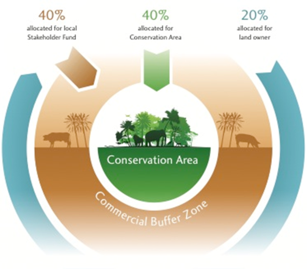
The fund administrator, NGO FUNDECODES, and other brokers promote CCUs to investors, who buy them for at least ten years. CCU returns are distributed for use across the different zones of the project area: 40% for conservation activities in the core area, 40% for sustainable production activities in the commercial buffer zone and 20% for the owners of the credit-generating land.

  • Conservation agreement between FUNDECODES and the Global Conservation Standard (GCS)
  • Current legislation allows conservation credits to be valued and sold
  • Institutional stakeholders which are committed to work with the private sector and civil society
  • Private sector willing to voluntarily offset
  • Brokerage: Bringing together demand and offer, e.g. buyers and sellers of CCUs
  • Stakeholders are empowered by the financing scheme because they receive financial support to implement conservation activities and are involved in decision-making and prioritization.
  • The project is recognized as a model by conservation authorities because it implements an environmental sustainability standard with support from strong partners.
  • There is high interest among Costa Rican private sector to compensate CO2.
  • International investors are interested in due diligence and full accountability when buying CCUs. This is guaranteed by GCS using independent accredited bodies to carry out annual assessments of carbon stocks, maintaining objectivity, accuracy and transparency and offering real-time GIS imagery.
  • There is still a need to improve the capacity of FUNDECODES and SINAC in marketing, brokerage, establishment of the MRV-System and adequate management of the “Small Project Funds”.
Feasibility study and benefit validation

A guided assessment of the forest areas suitable for the sale of conservation credit units (CCU) in the foreseen region is done with the Global Conservation Standard (GCS). The elaboration of a masterplan outline the project area and its potential to sell CCU (based on criteria by the IPPC). All interventions are defined through participatory planning (calculation credit generation, beneficiaries, marketing). Once the masterplan is accepted by GCS, the international registration is done at Markit.

  • Available scientific information
  • Technical guiding, capacity building and financial support of donor agencies
  • Political will of governmental and private landowners to cooperate and establish a Steering Committee with representation from public and private sectors
  • Involvement of FUNDECODES, a local non-governmental organization recognized by the stakeholders
  • GCS implementation is not linked to any transfer of ownership
  • There is no eligibility restriction on landscape type or geographical area
  • Agreeing on and establishing common goals is fundamental for participatory planning and local actors’ ownership of the project, which favors the development of proposals aimed at mitigating impacts produced by productive practices.
  • When the community leads local development of conservation measures, the pressures on the mangrove forest are reduced, supporting resilience and thus the health of the ecosystem services of the area.
  • The project acceptance depends on the positive perception by the local actors.
The Global Conservation Standard

The Global Conservation Standard (GCS) certifies ecosystem services in public and private owned forest/protected areas for carbon offsetting and marketing. Funds generated through the sale of conservation credit units (CCUs) of the forest area are invested in the conservation and promotion of sustainable production in the project area, which is divided into a conservation and a buffer zone with commercial activity.

  • Technical and financial assistance from project partners is available to do pre-feasibility studies to implement the standard.
  • Consent among and conservation agreements between the parties promote the sustainability of ecosystems.
  • A thorough review of international standards is important to identify areas where implementing a conservation standard is possible.
  • The selection of a standard defines and orientates the whole and following establishment process.
  • The information collected in the standards review is used in discussions with stakeholders as well as potential national / local investors to provide a solid foundation for informed selection of mechanisms to finance conservation of coastal and marine resources.
Joint adaptation planning
The Municipal Plan of Porto Seguro, was built in a participatory approach, under the governance of the Municipal Council for the Environment. This council is composed by representatives from the local and state government, local communities, NGOs, and the tourism sector. More than 120 people from different sectors participated in the workshops and meetings providing diverse collaborations, identifying local threats and opportunities, and proposing specific activities based on the knowledge they had about the region. The Municipal Council revised and approved the final plan that was then published and publically distributed. The co-management building approach is now being implemented for other Municipal planning, and being used as a reference for building the Plans for the Conservation and Restoration of the Atlantic Forest in nine other neighbor municipalities.
• The process was participatory from the beginning; • The governance system was clearly defined (Municipal Council for the Environment).
• The mobilization phase was critical for improving the interest of various stakeholders in participating in the development of the Municipal Plan. One staff person has dedicated one month to this, presenting the proposal and stressing the importance of the process. • Having the participation of multiple sectors was critical for a comprehensive view of the different ecosystems and activities analyzed. • Just a few Municipality Secretariats have participated in the process. Having a broader participation from the local government would improve the process.
Integrated Watershed Action Plan

The specific strategies for each watershed are identified in an Integrated Watershed Management Action Plan, which is adaptive and evolves from a scientific basis. The Plan includes specific actions to be implemented with the participation of public, private and local stakeholders. The Action Plan is jointly developed by local stakeholders and will enable priority watersheds to recover their functionality and better provide ecosystem services, such as clean water to support healthy mangroves that provide climate adaptation benefits.

  • The collaboration of local stakeholders.
  • A commitment by local stakeholders to implement the action plans.
  • Consideration of pre-existing efforts.
  • A local agent that leads the process.
  • There is previous work in some of the priority watersheds. Action plans should not ignore existing efforts, but promote an inclusive environment for all stakeholders to feel welcome to participate.
  • Action plans allow having healthier watersheds since the investments from different institutions are aligned.
Aligning public and private investments at the landscape level

The solution is funded through a combination of sinking funds and endowment funds from the Global Environment Facility (GEF), and matching funds from other donors and public funding. The endowment funds from the GEF provide long-term financing to address the conservation needs within the coastal watersheds and are partially dedicated to the basic operation of protected areas. Public sinking funds from CONAFOR´s programs and payment for ecosystem services mechanisms increases watershed connectivity. Grants finance sustainable forest management and agro-ecology projects. The Integrated Watershed Action Plan will help to align these public and private investments at the landscape level.

  • The capacity to raise funds from multilateral, bilateral and private donors.
  • Matching funds from three public agencies that enable private donations.
  • An experienced, professional trust fund manager.
  • Coordinating investments from multiple agencies at the landscape level enables greater impacts on watershed recovery and functionality.
  • Raising funds for conservation is more likely when public and private investment is committed to a common goal.
  • Different funding sources with different timelines associated with them (endowment and sinking funds) bring advantages for conservation goals.
Public-private collaboration

Three federal Mexican agencies as well as a private organization are joining efforts for the conservation of priority watersheds. This is formalized by a letter of intent for collaboration stating the common goal all are working towards.

A technical committee with representatives of all institutions is formed and takes decisions. It meets every two months, and supports the implementation of the project. A participatory platform is set up at the local level in each of the regions, allowing local stakeholders from different sectors to get together and decide on activities to promote within the watersheds.

  • Public and private institutions have the willingness to collaborate for a common goal.
  • A technical committee for decision making with representation of all institutions involved gathers several times a year. Decisions are made by consensus.
  • Local organizations and governments considered as a key stakeholder by the technical committee jointly develop the Integrated Watershed Management Action Plans.
  • Inter-institutional collaboration tackles severe effects of climate change in vulnerable coastal environments, by ensuring adequate planning in the watersheds.
  • The technical committee, which includes representatives of all institutions involved, ensures transparency and adequate operation of the project.
Reef enhancement for coastal protection
While sea walls, boulders, and other hard approaches to coastal protection are the right approach in some areas, they are also very expensive, high maintenance, and destructive to the living shoreline we all treasure. Nature-based solutions seek to integrate built structure, natural systems such as reefs, beaches, mangrove and coastal woodlands, and forests. Nature-based solutions are often much cheaper, and also provide greater benefits such as food production and beautiful places for people to recreate. This project seeks to install reef structures designed to provide fish and coral habitat, and break wave energy and ultimately reduce coastal erosion and flooding. The design phase included detailed measurements of the seabed, wave energy modeling using data from the past sixty years, and coastal engineering. Local labor and equipment was used to install a first set of structures. The installation took a total of three weeks and constitutes one of TNC’s most important pilots to test nature based solutions to climate change.
• Community understanding the importance of and the benefits to be derived from the successful implementation of the project. • Community acceptance, participation in the project process and ownership of the project. • Involvement of and participation of Government Ministries and departments in the project processes. • Partnerships with the Grenada Red Cross and NGO Grenada Fund for Conservation and other community groups that assisted with mobilizing communities and empowering stakeholders.
• Community engagement and buy-in at all stages, as well as partnerships with local organizations and community groups, was critical for successful implementation. • Accuracy of bathymetry data available (we used satellite derived data but this lead to inaccuracies and delays during installation; access to LIDAR (Light Detection and Ranging) data would have been ideal). • Given the experimental nature of this block phasing of installation was critical. • Employing a local commercial dive operator and local divers was critical, during installation since the commercial diver’s experience and the divers’ knowledge of local context has been invaluable.
Participatory Forest Management plan
  • Participatory management plan aims to support the local community to sustainably manage mangrove forest within the LMMA.
  • Using printed high resolution Google Earth map, a first draft management plan is created by each concerned (proposed project area for the mangrove carbon project) village with the boundary of the mangrove zoning (core zone, reforestation area and sustainable logging area).
  • When all the concerned villages within the LMMA have completed the zoning, the data from the Google Earth map are digitalized and projected in a big screen for validation. Delegates from each village are invited to attend a workshop for the validation of the mangrove zoning. For the validation, at least four people from each concerned village must attend. Ideally both men and women are elected by villagers who they feel may best reflect their opinions (elders, chef Village).
  • Each community determines, agrees and implements the rules and regulations governing each mangrove zone.
  • This is conducted through a large village meeting. The support organization facilitates the process until the local law is ratified at the court.
  • A local convention or law enables communities to govern the natural resource management;
  • Aptitude of the support organization to incorporate the mangrove management plan into the existing LMMA management plan;
  • Ability of the law enforcement committee to enforce the Dina and deal with the fine payment in their respective zone without support/inputs from the government;
  • Demarcation of the management zone enables community to observe on the ground the boundary of the mangrove zoning.
  • The support organization must be familiar with the government law as the local laws/conventions (such as Dina) should not be in conflict with the national law. It has proven effective to involve appropriate government actors in processing the Dina (local law) at the village level to make the ratification easy.
  • Make sure villages sharing mangrove forest are consulted together through village meeting/workshop for a compromise on the mangrove zoning. For the demarcation at the forest, delegate from village at the AOI must assist the technician staff from the support organization to make sure that the marks/signs are in the right place.
  • Color of the marks/signs used for the demarcation should consistent be within the LMMA (e.g color red for the core zone boundary for both marine area and mangrove forest).
Participatory mapping for management

Participatory mapping is undertaken with communities to understand spatial patterns (land use, land tenure, land cover type and historical change and trend) and the state and use of mangrove resources in the project area.The participatory mapping creates maps which will later support the management planning/zoning. Google Earth imagery covering the whole area of interest (AOI) combined with questionnaires is used to assess community perceptions of resource use. All stakeholders (farmers, loggers, fuel wood collectors, charcoal producers, lime makers, elders and fishers), identified through interviews with key informant(s), are involved on this exercise and are created resource use map of the AOI. They are divided according to activity groups and the number of people per each group should be at least 5. Only one person is designated to the group to draw the boundary of each land use type on the map. Ideally each group should be assisted by one staff member from the support organization. Each group comprises a range of sex and age (male and female/young and old) that are already active in the respective activities (usually over 15 years old).

  • High resolution Google Earth map of the area is available and contains familiar landmarks (e.g school building, church) to facilitate community reading.
  • The questionnaires for the stakeholders aiming to gather additional information about the resources use is available and translated into local dialect to avoid confusion.
  • Make sure the village is informed in advance and would be better to check with community their convenience time to undertake the exercise (neap tide when they are not going for fishing or at spring tide when they get back from fishing,);
  • The mapping exercise should last between 2 hours and 3 hour to ensure that the stakeholders are focused on the activities.
  • The staff from the support organization should be familiar with the local dialect and avoid using scientific/very technical word.
  • Consensus between groups must be respected before drawing/delineating the boundary on the map.
  • The facilitator must be able to make a quick analysis of information given by the community during the exercise.