Carbon inventories in mangrove ecosystems
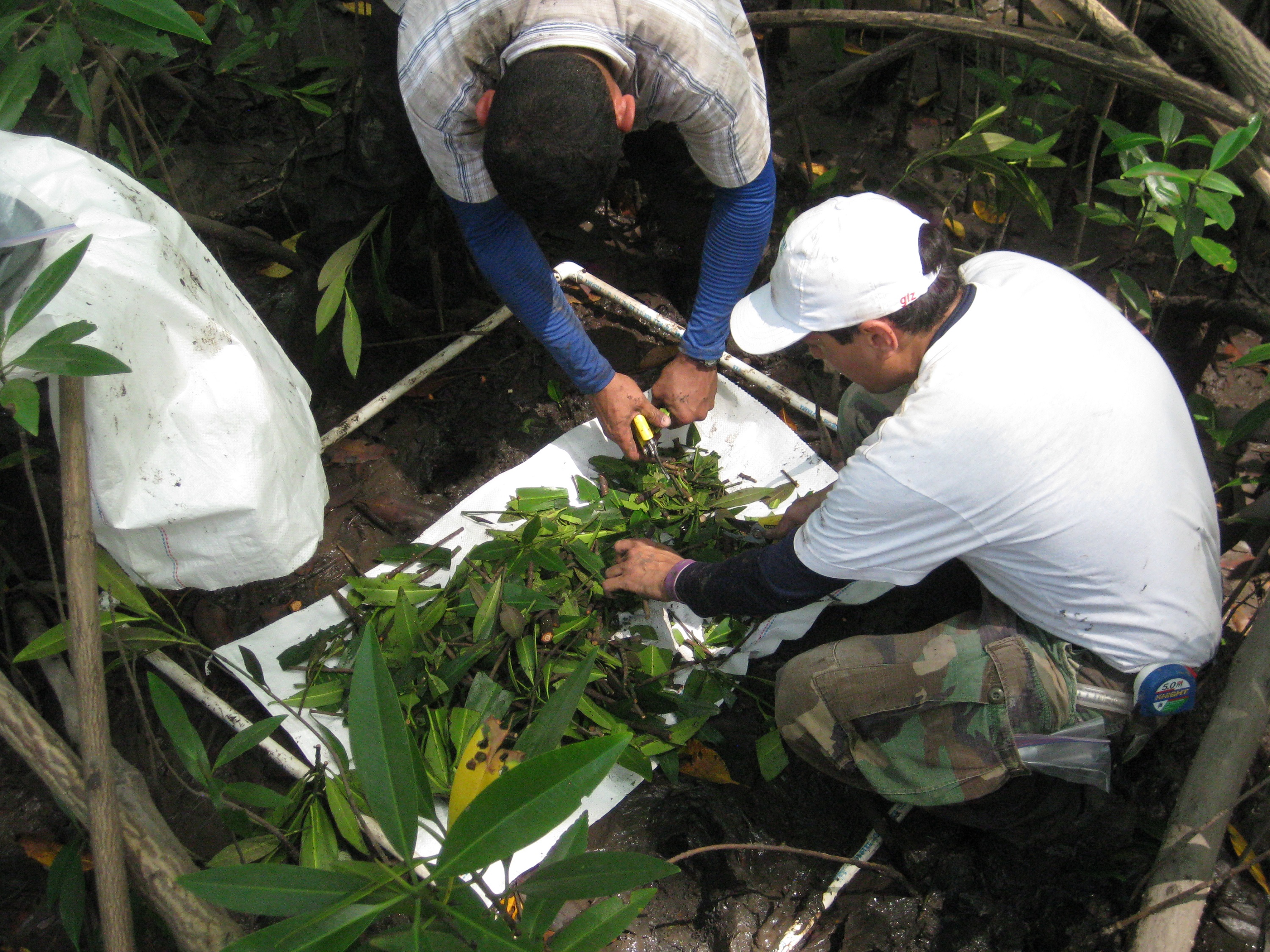
Carbon inventories provide the basis for quantifying current stocks and mangrove areas needed to estimate historical emissions. They allow for characterization of the environment, description of the flora and horizontal and vertical structure of the stands, plus their condition. Carbon assessments can also kick-start local involvement and capacity building. When repeated over time under a robust monitoring system, they provide growth and carbon accumulation rates that are used to calculate higher quality emission numbers than those currently available.
The involvement of government and local authorities is key. Government officials (local and national) are made aware of the process so they can recognize the value of the inventories in providing detailed data on highly vulnerable ecosystems. Involvement of local actors is key so they are empowered and acquire ownership of the project. Also, their knowledge of the area supports project site selection and ensures safer working conditions.
The quality of the inventories depends upon the use of consistent protocols and the level of trained personnel. Work in mangrove forests is more challenging than in terrestrial ecosystems, and safety of the workers needs to be a strong priority. The logistics of using boats to access field sites, short windows of time between tides, plus the difficult terrain preclude swift completion of tasks which, in turn, increases costs and duration of field work. With local involvement, these costs may be controlled, as boat rental fees may be lowered or waived. Also, collecting and processing soil samples in the field is challenging because of their extreme high water content, implying that laboratory facilities need to be arranged in advance. Having local people involved with the inventories is highly recommended because of their first-hand knowledge of the area, tide behavior and land use dynamics. GIS tools facilitate inventory planning.
Adaptive and participatory locally based management
Communities develop management plans and monitoring protocols based on biological, ecological, socio-economic, cultural and historical gap analyses, as well as mutually agreed targets and objectives. The necessary collection of scientific baseline and monitoring data is conducted in parallel. Additional management activities include establishing proper record keeping and reporting, and building up enforcement mechanisms for protected areas, including prosecution of illegal fishing or poaching.
• Community resource ownership, including a clear view of potential benefits for current community members and future generations, which will result from conservation actions to address perceived ecological problems. • Support from local and international partners (e.g. NGOs) to assist with management planning, monitoring, and collection of scientifically sound data.
The establishment of a bottom up management approach is a challenge, particularly if traditional leadership is weakened. However, traditional and modern systems can be merged based on dialogue and capacity strengthening at the community level.
Long-term monitoring
Regular and long-term monitoring for at least 3-5 years tracks changes over time, which allows early modifications to correct problems and helps determine if the project’s objectives are achieved. Monitoring is scheduled at prescribed monthly intervals.
To be provided by solution provider.
The monitoring method used needs to fit the project requirements and the skills, time, and budget of the monitoring team. The restoration process depends on the natural cycle of seed production and recruitment while donors and sometimes communities want to see quick results. As a result, although overall costs may be lower, the method requires a longer funding and monitoring time-frame as usually granted.
Customized mangrove restoration
Once appropriate restoration areas are selected based on scientific analysis and site assessment results, a restoration program is designed using assisted natural plant recruitment. Topographic surveys using an auto-level determine relative substrate elevation, and water level is measured with simple tools such as rubber tubing and meter sticks. Site hydrology and original tidal streams are important natural volunteer mangrove recruitment for natural plant establishment. Strategic breaches are created in dike walls, and observations are made to identify if natural seedling recruitment is occurring once the stress has been removed. The effectiveness of hydrological rehabilitation is re-evaluated if no seedlings have established in the area, and planting of seedlings only takes place if natural regeneration is not successful.
• Good relations with the relevant government agency facilitate the approval process for implementing the project, such as using heavy equipment in the mangrove zone to repair the hydrology if needed (which may be illegal, such as in Thailand). • Suitable funding needs to be put in place to ensure the project can be completed within the planned timeframe.
The community-based ecological mangrove restoration process is only a guide and needs to be adjusted to each specific site. Mangrove seed source should be available from nearby mangroves which enter the pond or system at high tide and soil conditions are muddy, clay-silt. The presence of nurse grasses is often important to start the regeneration process as they are able to capture the propagules and seeds. The concept of allowing forest to regenerate naturally is a very foreign concept to some government agencies. As opposed to traditional monoculture mangrove planting that creates long-term employment in nurseries and at planting sites, this method creates very little local employment, especially if heavy equipment is used. Therefore, finding ways of employing local people in the protection and maintenance of the restoring site is a challenge. Available labor to carry out the project should be considered, with defined quantitative goals.
Site suitability assessment
Knowledge of past human uses and impacts on potential restoration sites can support decisions on whether an area is presently suitable for mangrove growth. This includes assessing the modifications of the mangrove environment that have occurred, and identifying and removing potential stresses such as blocked tidal inundation that may prevent natural secondary succession before attempting restoration.
• The restoration site should have been a mangrove ecosystem previously. • Access to information which provides a full historical view on previous land-use and impacts, as well as ecological and hydrological information.
It is important to understand the past human use of the area. Oftentimes, mangroves are planted in areas such as mud flats, salt marshes, or lagoons assuming that the area would be better off or more productive as a mangrove forest. In some locations, government agencies charged with the mangrove management do not want to give up sites for community-based restoration, as such agencies obtain their budget based on the area they themselves plan to restore, which is mainly for raising seedlings in nurseries. Thus, conflicts may arise as the method used in this solution promotes the concept of allowing forests to regenerate naturally, as opposed to traditional mangrove planting methods, i.e. planting Rhizophora species for charcoal production. Another major challenge is the conversion of abandoned shrimp ponds into oil palm plantations with funding from the respective government agency. Many areas for mangrove rehabilitation to protect coastal communities are thus lost.
Historical and ecological background information collection
To identify suitable restoration sites, data is collected on land tenure, historical changes, local utilization, mangrove distribution, and tidal requirements. Information sources include recent or even historically relevant aerial photos, maps, reports, and tide charts. Other important assessment factors include the ecology of naturally occurring mangrove species and healthy forests (e.g. reproduction patterns, distribution, successful seedling establishment) and physical site characteristics, such as hydrological (e.g. critical periods of inundation and dryness), slope and topography parameters.
• Scientific and technical know-how and support from...
To be entered by solution provider.
Community awareness, participation and stewardship
Local communities are engaged in the early planning stages to build awareness and to ensure full participation. This includes discussing restoration objectives, protection plans, and co-management principles. Community members receive trainings, participate in hands-on development of small-scale community nurseries, and assist in the monitoring process by observing tidal exchange, measuring seedling recruitment, and conducting time lapse photo monitoring. Project managers connect the community with the responsible government agency to gain their support and sign an agreement if required.
• Interest and willingness of the community; • Clear future social benefits (goods and services) for the community; • Suitable land-tenure or land-tenure that will not be a jeopardising factor; • Appropriate funding, if possible long-term financing (> 3 years).
Without strong community participation from the project’s inception, stewardship may not be achieved, putting the project at risk. Also, good collaboration between the community, the responsible government agencies and the NGO is a basis for the success of the project from inception onwards. Linking restoration objectives with local livelihoods is also important for engaging community members. One success factor critical to the planning phase is a secured land-tenure, which sometimes consumes more project time and resources than finding and securing restoration sites. Persons holding tenure of abandoned shrimp ponds usually do not want the area restored back to mangroves, as the government may take back the land title once the mangrove ecosystem is restored.
Development of multi-use MPAs

Two multi-use MPAs have been developed between researchers, fishers, and the Ministry of the Environment in the district of Bejuco to better manage the local snapper stock. These areas allow for the use of artisanal bottom longlines (the preferred fishing gear of the area’s snapper fishers) and hand lines but do not permit more unselective methods to be used including shrimp trawl nets. Costa Rica’s coastal MPAs began as marine extensions of previously established protected terrestrial areas, and Bejuco’s MPA are no different. Their original intent was to protect sea turtles from shrimp trawlers, but they have evolved into more complex spatio-temporal coastal resource management tools.


The area’s MPAs provide a legal framework that protects the interests of local fishers against the industrialized shrimp trawl fleet (shrimp trawlers target snappers in the area because it is not economically viable to fish for shrimp in Costa Rica). Costa Rica is developing climate change adaptation strategies funded by the Adaptation Fund. Inherent in these is the continued development of protected marine areas and the feasibility of expanding the two existing areas is being discussed.

Bejuco’s MPAs were established 10-15 years ago. Their original focus was rooted in sea turtle conservation and did not contemplate ecosystem management strategies. As the importance of the country's artisanal fisheries becomes more understood and appreciated, its MPA system has been forced to evolve, leaving ample opportunity for its improvement and expansion. For this reason, sea turtle data, fishery data, and local management plans are being combined to justify their expansion in Bejuco.

A multi-use MPA management plans that is enforceable and appropriately represents the community’s interests is just as important as the establishment of the MPA itself. Unfortunately, the Costa Rican system of coastal/marine governance is fragmented between two separate entities, the Environmental Ministry and the National Fisheries Institute. These separate establishments do not communicate effectively with one another. Furthermore, the Bejuco MPAs do not have their own management plans, but rather a few added paragraphs to the wildlife refuges’ plans. This has led to governance and enforcement gaps that have been exploited by illegal (gill net and shrimp trawl) fisheries.

Catch Composition Data Collection and Analysis

In order to develop and manage an environmentally sustainable fishery, a number of performance indicators need to be established for its target species, common bycatch species, environmental factors, and management regimes. Examples of these for the Bejuco artisanal bottom longline snapper fishery include the stock's status, bycatch and discard rates, endangered and/or protected species catch rates, gear impacts to the seafloor and associated benthic organisms, local management plan, and national fisheries management capacity. Since 2007, the catch composition of the Bejuco bottom longline fishery has been continuously monitored by dock side observers and researchers who accompany fishers on their nightly trips. This information, along with the collection of fisher ecological knowledge, has allowed researchers to identify many of these indicators. In close collaboration with the national government, protected area and management plan development initiatives are also taking shape.

Collaboration between researchers (NGO collaborators and university students) and the local fishers needs to exist. A certain level of trust must be established between both parties in order to create this type of environment. Project researchers and other associated NGO members were invited into the fishing communities by fishers themselves, thus facilitating this process.


Data collection expenses have been primarily shouldered by international NGOs (grants) and research students (institutions).

A relationship based on mutual trust must be established if long term data collection efforts are to be successful. Fishers must know that researchers will not use catch information against them to further compromise their industry, and researchers need to be assured that they have full fisher support and open access to their operations. Data must also be recorded throughout the entire year (or fishing season) and not just “when the fishing is good”. There are months when this fishery produces almost no snapper. This data is valuable. Researchers ran into a statistical analysis problem because they stopped taking data when the catch per unit of effort dropped. This created a bias in their analysis.

To facilitate the long term collection of data, researchers are working with the government to train fishers to record their own catch and determine the reproductive states of certain species. A smartphone App is also being developed to facilitate the data collection process by fishers.

Communication of scientific Results
Communicate findings on larval connectivity and their implications to stakeholders and decision-makers at all levels (village, municipal, provincial) to emphasize importance of efficient MPAs and MPA networks. Improved understanding on larval connectivity helps stakeholders and decision-makers to enhance governance of existing and planning of individual MPAs and MPA networks. Also, share results with the international and national scientific community.
Conditions for adoption elsewhere • Existence of coastal management initiatives at village, municipal and/or provincial levels • Experience of at least some stakeholders in establishing multiple MPAs is advantageous
The cooperation and support of the Environmental and Natural Resources Divisions in Negros Oriental Province, Philippines represents a major success factor. Thus organisation of information dissemination and conducting workshops with all stakeholders in different municipalities was made possible.