Quick Response Unit acting on suspicious threats based on real-time data
Leveraging real-time alerts from ScannerEdge, a response unit can quickly assess and mitigate potential threats, such as poaching or other illegal activities.
Purpose: To translate RF signal detection into actionable insights that trigger swift response actions in the field.
How it Works: Alerts are routed to dedicated response teams equipped to investigate and intervene. ScannerEdge’s GPS functionality and integration into EarthRanger aids in pinpointing signal sources for precise action.
Response protocols must be clearly defined to avoid delays in decision-making.
Collaboration with local enforcement agencies enhances the effectiveness of rapid response teams.
Real-time response is more effective when combined with predictive analytics based on historical ScannerEdge data.
ScannerEdge specializes in monitoring RF signals from mobile and satellite phones, as well as other communication devices, to detect human activity in remote areas.
Purpose: To provide real-time intelligence on human presence or illegal activities by detecting and analyzing RF signals within a 3 km radius.
How it Works: ScannerEdge scans for RF signals (UMTS, Wi-Fi, Bluetooth, satellite phones, and VHF radios) and transmits alerts via LoRaWAN or satellite connectivity. Data is centralized for further analysis and decision-making.
ScannerEdge’s ability to integrate with multiple communication networks LoRa/Satellite ensures reliable data transmission even very remote regions.
Satellite data transmission, while robust, can be cost-prohibitive and requires funding models that accommodate operational expenses.
Proper calibration to filter false positives is critical for actionable intelligence.
Ensuring that ScannerEdge devices are properly installed and configured in the field, with thorough training for operators to maximize their effectiveness in detecting illegal human activities.
Purpose: To equip field teams with the skills and knowledge to install, operate, and maintain ScannerEdge devices, ensuring continuous functionality in diverse environments.
How it Works: ScannerEdge is installed in strategic locations, configured via Bluetooth through a smartphone app, and calibrated to local RF conditions. Training includes understanding signal detection, troubleshooting, and device maintenance.
On-site, hands-on training yields better outcomes than theoretical sessions alone.
Operators need to understand both the technical and practical implications of the data collected.
Regular follow-ups improve long-term device functionality and user confidence.
Committee establishment, formalization and operationalization
Inclusive and participatory mapping of all stakeholders in the mangrove space in the five counties of Kwale, Mombasa, Kilifi, Tana River and Lamu. A series of meetings for sensitization on the National Mangrove Management Plan, and later facilitated formation of the national and five county committees. The committees were then facilitated in developing their workplans and executing some of the activities. This has since been picked up.
Forest Conservation and Management Act, No. 34 of 2016
An Act of Parliament that provide for the development and sustainable management, including conservation and rational utilization of all forest resources for the socio-economic development of the country and for connected purposes
Provides for overall management of forest in the country
Quick Response Unit acting on suspicious threats based on real-time data
Building Cross sectoral Partnerships
Connecting the public
WILD FRIEND
TENCENT
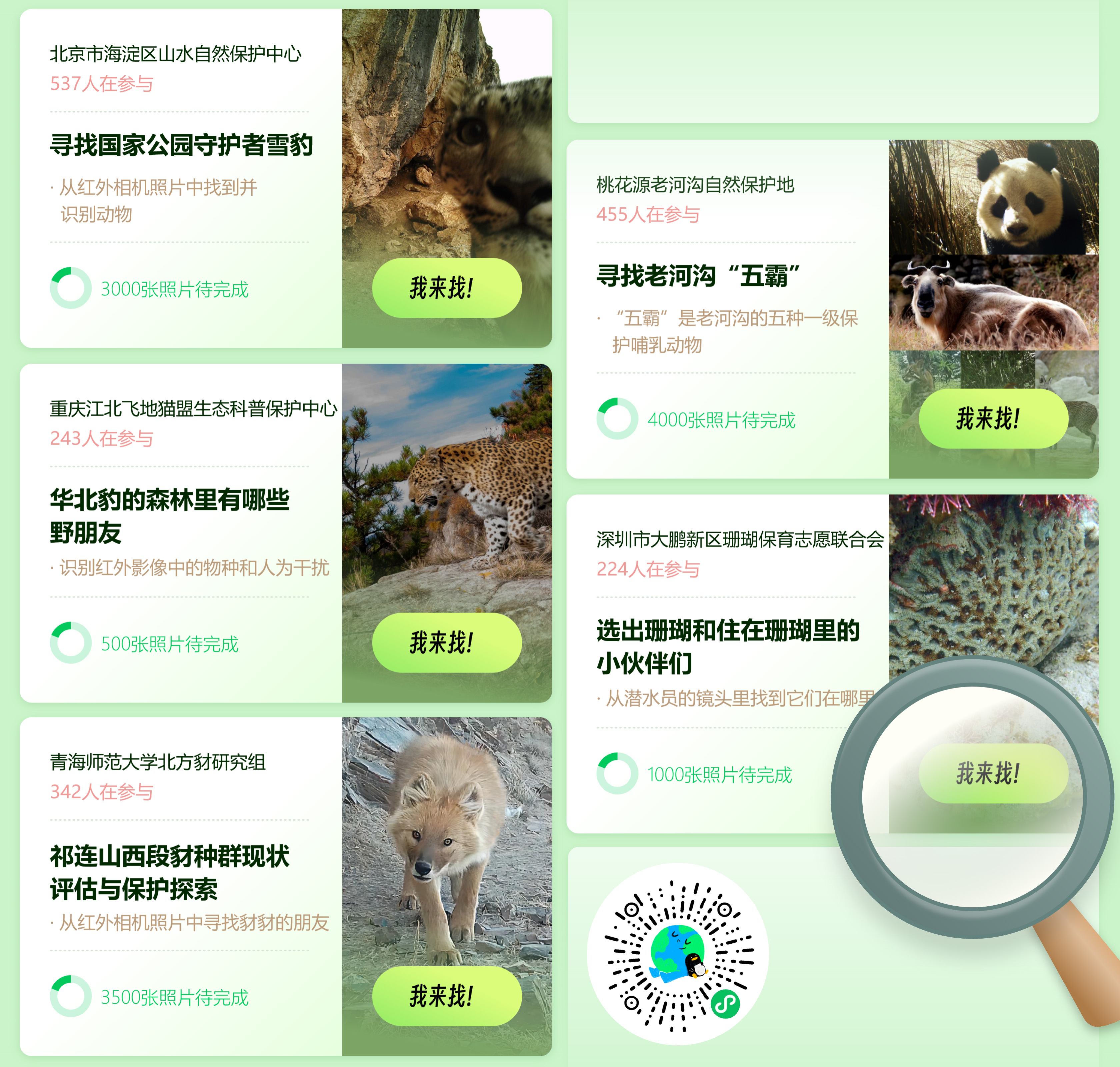
Connecting the public: This mini program aims to promote the mainstream of biodiversity conservation by desensitizing current monitoring data in the industry and designing low threshold interactions for the traditional data labeling process. This allows the public to participate in the training process of biodiversity models in a more accessible and intuitive way through the mini program. On the one hand, the public can enjoy and learn about the most authentic protection monitoring images through the form of "playing games"; On the other hand, the power of the public can be utilized to continuously train a universal model of biodiversity, achieving the goal of citizen science in the process. Through product design, 'Wild Friends' breaks down the process of annotating and verifying institutional data into tool based tasks, reducing the initial training costs of institutions. With simple guidance, volunteers or the general public can complete basic annotation content. The first step is to check for the presence of animals (manually identified or judged by AI); Step two, estimate the number of animals (manually determined); Step three, select animals (manually or through AI evaluation of selection accuracy); Step four, identify the name of the animal (manually selected or judged by AI); Step five, randomly allocate cross validation in the background. Ensure the accuracy and consistency of data.
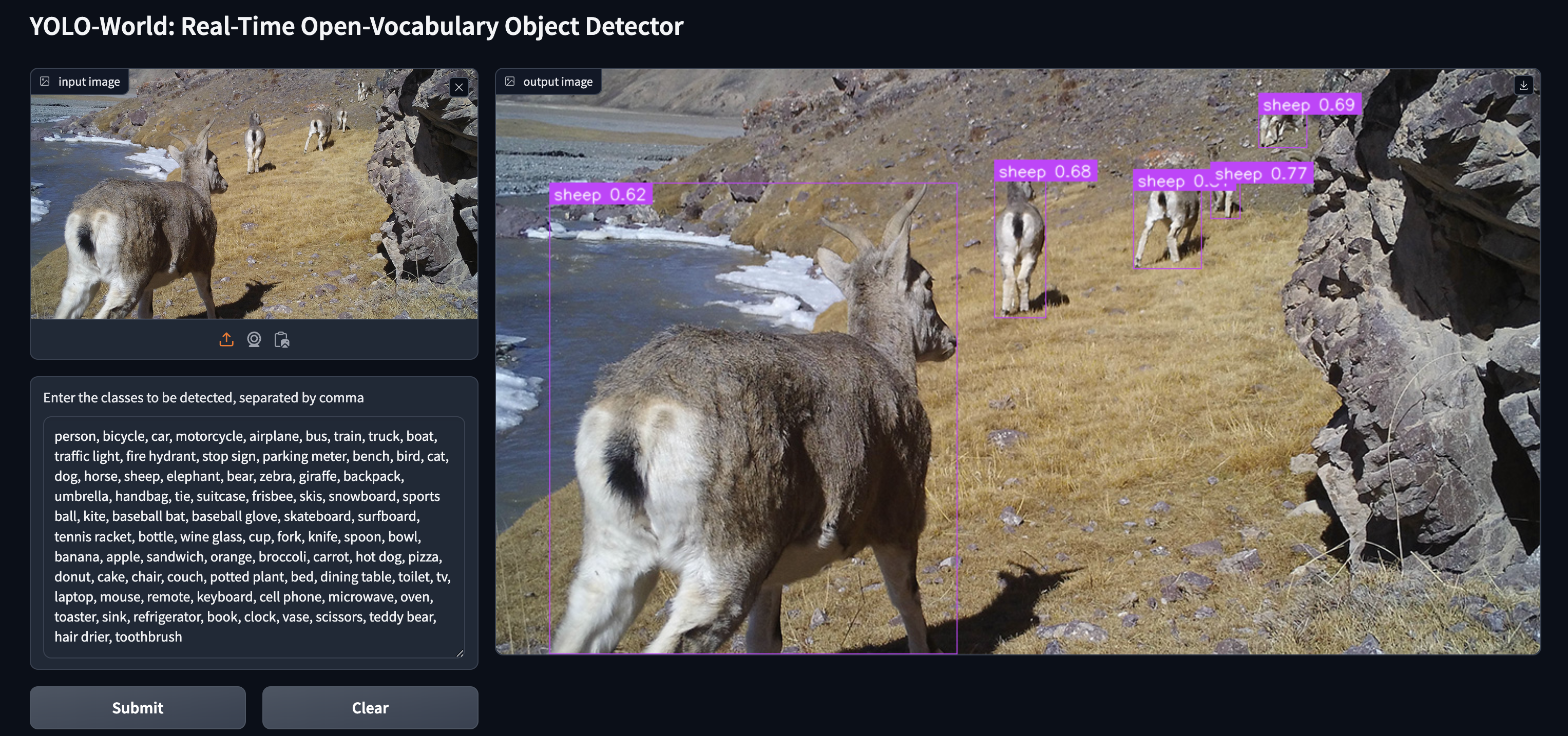
AI species recognition: This product uses AI recognition as the underlying technology, with endangered species as the core recognition object. It trains a large biodiversity recognition model that can support monitoring of mountains, rivers, forests, fields, lakes, grasses, and sands systems. The model is free and open to public welfare organizations dedicated to biodiversity conservation, such as research institutes, conservation organizations, and individuals. The reason why "wild friends" are so powerful is because they have a powerful "engine": YOLO World. As the underlying universal model of 'wild friends', its primary characteristic is strong learning ability. It has powerful multimodal zero sample recognition and few sample recognition capabilities, which means it can quickly identify animal location regions and species information of multiple species through a small number of samples. For example, to recognize a new species, traditional models require thousands of photos and several days of training; YOLO World only requires a small number of photos and training iterations to achieve rapid adaptation. Secondly, it has a high degree of tolerance. No longer limited to training and prediction of specific species, it has strong open vocabulary recognition ability and zero sample recognition ability, and can accurately identify and locate untrained species. For example, traditional models can only recognize trained species such as tigers and antelopes; The new model can also recognize snow leopards and foxes simultaneously - even if it has never trained these two animals before. Another advantage of "wild friends" is that they spend less money. Common AI models heavily rely on high-performance acceleration cards, which result in high costs for both hardware environment and maintenance operations.
Connecting the public: This mini program aims to promote the mainstream of biodiversity conservation by desensitizing current monitoring data in the industry and designing low threshold interactions for the traditional data labeling process. This allows the public to participate in the training process of biodiversity models in a more accessible and intuitive way through the mini program. On the one hand, the public can enjoy and learn about the most authentic protection monitoring images through the form of "playing games"; On the other hand, the power of the public can be utilized to continuously train a universal model of biodiversity, achieving the goal of citizen science in the process. Through product design, 'Wild Friends' breaks down the process of annotating and verifying institutional data into tool based tasks, reducing the initial training costs of institutions. With simple guidance, volunteers or the general public can complete basic annotation content. The first step is to check for the presence of animals (manually identified or judged by AI); Step two, estimate the number of animals (manually determined); Step three, select animals (manually or through AI evaluation of selection accuracy); Step four, identify the name of the animal (manually selected or judged by AI); Step five, randomly allocate cross validation in the background. Ensure the accuracy and consistency of data.