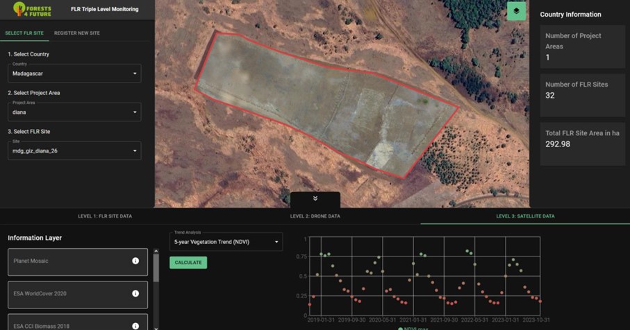

Satellite data forms the bedrock of the 3LD-Monitoring system, harnessing the capabilities of open-source imagery from the Copernicus Sentinel-2 and LANDSAT satellites. An algorithm, meticulously developed by Remote Sensing Solutions (RSS) GmbH, revolutionizes this process. Users can seamlessly submit the shapefile of their area of interest, prompting the algorithm to automatically fetch and analyze relevant data. A spectrum of robust analyses are conducted including the 5-year vegetation trend using NDVI for assessing vegetation gains or losses, 5-year vegetation moisture analysis through NDWI, and a nuanced 5-year rainfall trend evaluation. Additionally, the algorithm facilitates the visualization of vegetation changes since the inception of the project, bolstering the monitoring framework with dynamic insights. Satellite data, a vital component of the 3LDM-Monitoring system, leverages open-source imagery from the Copernicus Sentinel-2 mission and LANDSAT satellites. For predefined areas, this data is automatically fetched and analyzed for specific parameters. Key analyses include a 5-year vegetation trend using NDVI as a proxy for vegetation gains or losses, a 5-year vegetation moisture trend through NDWI, and a 5-year rainfall trend. In addition vegetation changes from project start can be visualized.
Effective use of this building block hinges on users drawing and saving areas in GIS platforms like QGIS. Additionally, enhancing the shapefile with project specifics, such as start dates and FLR type, optimizes analysis. Proper training in these skills ensures accurate data input and tailored monitoring, making capacity building in these areas essential if not present.
While satellite data, especially open-source, offers broad insights, its capability for species identification is highly restricted, if not unattainable. This limitation emphasizes the indispensable role of field work in discerning species composition and characteristics. Additionally, understanding the innate constraints of satellite imagery, especially with young tree plantations, reinforces the need for integrating field and drone data to gain a comprehensive view of forest terrains.