Partner fishery selection criteria and process

To maximize SmartFish’s impact, we drew on empirical research and years of experience to establish fishery selection criteria. Fishery partners must:


           a) Be formally organized, with effective institutional structure (eg a cooperative) that includes mechanisms for decision-making, for enforcing group decisions and a collective understanding of and commitment and adherence to fishery sustainability principles;

           b) Have previously and formally adopted sustainability measures (eg: fishing reserves, daily catch quotas, or size limits);

           c) Target biologically resilient species.


We established an Impact Division within SmartFish to determine the elgigibility of potential fishery partners as well as to track the social, environmental and business performance of partners before, during and after our interventions. Please see Impact Evaluation building block for more information.

Mexico's strong tradition for cooperatives coupled with legal and fiscal underpinnngs for them have resulted in among the strongest fishing cooperatives worldwide. We prefer to work with co-ops that have self organized to ahcieve strong social and environmental performance. However we are also happy to collaborate with groups that have been assisted by NGOs (eg COBI AC, Niparajá AC, and ProNatura Noroeste AC) to improve social and environmental performance enough to meet our strict criteria.

Cutting corners on these criteria can create problems. While we would like our model to work for all fishers, if they are not formally organized, with effective institutional structure (eg a cooperative), our Value Rescue interventions cannot function.  


We thus partner with fisher groups that are already performing well socially and environmentally. Groups that are impriving are considered, and for this we depend on strong collaborations with NGOs that specialize in the improvement of coooperatives' social and environmental performance.

Continuous monitoring

In order to ensure that the scenery values of the area are effectively protected, interested community members are trained in monitoring of scenery values using standardized techniques. Selection of trainees and implementation of continuous monitoring are done in coordination with the community.

  • Community support - Involvement of local communities
  • Conditions for adoption elsewhere.
  • Participatory process involving managers and experts.
  • It is important to encourage and support the community to play an active role in the management of the coastal scenery.
  • Management of coastal scenery will never be self-sustaining until the communities no longer require external assistance.
Coastal Scenery Management Plan

The coastal scenery classification is used by coastal managers, planners, academics, and governmental agencies, and local coastal zone managers. Evaluation of environmental, physical and usage parameters enables the identification and characterization of variables, which must be managed more effectively in order to promote overall improvements of the scenic value. Most sites have physical parameters for which coastal zone managers can do little or nothing to alleviate scenic impact, so emphasis should be given to assessing ways of improving different human usage parameters (i.e. litter collection campaign, fixing sewage-related problems, noise, access, utilities, etc.). Existing management plans can be revised or developed to consider scenery related issues by updating conservation targets’ statuses, identifying additional conservation targets, reviewing and revising weaknesses, and adjusting strategy and monitoring protocols. Additional scenery evaluations are required in order to evaluate plan effectiveness. The scenery management tool ensures a better littoral zone and long-term goods and services for local communities and tourists. It guides littoral managers to anticipate future impacts from human interventions.

  • Scenery Assessment outcomes as a basis for management plan development
  • Involvement of local communities
  • Training sessions on how to include scenery evaluation into existing management plans
  • Participatory process involving managers and experts.
  • Encourage local communities and authorities to identify issues and come up with their own solutions which can be applied at the local level.
  • Involvement of national government representatives is also a guarantee that the project will follow national guidelines and policies on littoral management.
Coastal scenery value determination

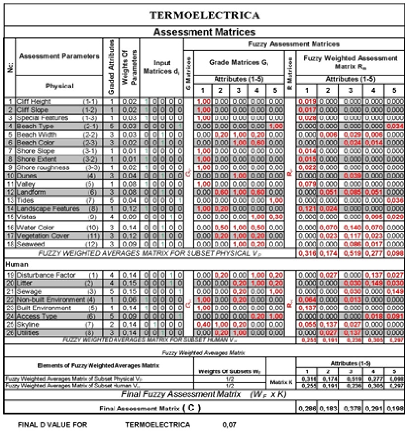
Scenery is a resource that has to be evaluated in an objective and quantitative manner to provide a means of comparison against other resource considerations and environmental impact assessments. Stakeholders survey specific littoral areas to determine the Scenic Evaluation, which indicates the ‘beauty’ of the study area. This is performed by using a coastal scenery survey checklist which itemizes 26 physical and human parameters, as a first step in quantifying scenery values.

  • Select and georeference the limits of the study area to replicate the survey in the future
  • Centralize information. There are often many people involved, multiple surveys, and lot of data, but just one previously-designated stakeholder is in charge of the analysis.
  • Organization - scheduling activities is important.
  • Data collection can complement a school class about coastal zone-related topics (geomorphology, geology, biology).
  • Data sources should be in a good balance. Local knowledge and stakeholder consultation are necessary.
Scenic Evaluation Tool Development

As part of a three-year study, an assessment was made of the main parameters essential for documenting coastal scenery perception. The assessment included a literature search, questionnaires given to coastal users in different parts of the world, and consultation with coastal landscape experts. Landscape values ‘can be assessed and described or illustrated in objective and subjective terms by landscape professionals, consulting with a wide range of interest groups and people and analyzing all relevant information’. Results obtained through this work enabled key elements to be condensed down to 26 ‘coastal scenic assessment parameters’. These parameters are: Cliff Height, Cliff Slope, Cliff Special Features, Beach Type, Beach Width, Beach Colour, Shore Slope, Shore Extend, Shore Roughness, Dunes, Valley, Land Form, Tides, Landscape Features, Vistas, Water Colour, Vegetation Cover, Seaweed, Disturbance Factor, Litter, Sewage, Non-Built Environment, Built Environment, Access Type, Skyline, Utilities.
  • Basic knowledge of spreadsheets
  • Work related with checklists
  • Consultation with experts is necessary
  • Avoid subjectivity
  • Data sources should be in a good balance
Mangrove protection and planting

Bamboo T-fences are used to restore eroded floodplains and the fine sediment balance as a precondition for natural regeneration of mangroves forests – the latter will then form part of an effective area coastal protection strategy. After successful restoration of sites suitable for mangrove growth, natural regeneration of mangroves will occur. It is, however, essential that the mangroves are protected from human impacts, otherwise the cycle of degradation/destruction and expensive restoration will continue uninterrupted (see illustration under "How do the building blocks interact in the solution?"). This can best be achieved by involving local people in effective protection and management of mangroves through co-management. For more information see solution “Co-management (shared governance) of natural resources in the coastal area”. If rates of natural regeneration are insufficient, supplementary planting of mangroves may be necessary. In such cases, appropriate species need to be planted at the right sites at the correct time.

• Decision-makers understand coastal processes and mangrove ecology. • All stakeholders are willing to engage in shared governance (co-management) of mangroves.

Co-management, or shared governance, is an approach for sustainable and effective mangrove protection and management. It also provides livelihood for local people and contributes to better governance of natural resources. The results of the fixed-point photo monitoring from the coast of Soc Trang Province (Vietnam) from Nov. 2012 until Jan. 2015 clearly show the impacts of T-fences on sedimentation and, as a result, on natural regeneration of mangroves. Mangrove foresters need a sound understanding of mangrove ecology and of coastal processes and morphodynamics. The most effective way of planting mangroves is to learn from nature, i.e. mimic how nature plants, which species nature plants and the way nature creates a species zonation. This zonation leads to optimised coastal protection through wave attenuation by above-ground root structures along with soil stabilisation by below-ground root structures (see illustration in "How do the building blocks interact in the solution?").

Breakwater monitoring and maintenance

A monitoring system is used to measure sediment accretion, and to monitor the condition of the T-fences. In addition, natural regeneration of mangroves is monitored. During the first year after construction, functionality of the T-fences should be ensured through monthly visual inspections and maintenance where necessary. After one year, visual inspections and maintenance should be carried out at least after the end of every storm season. In addition, seasonal GPS surveys of the shore line at low tide can be used to see whether the T-fences have impacts on the shape of the coastline nearby. The natural regeneration of mangroves is documented by recording species, size and density or through fixed-point photos. The latter can also be used as a simple alternative for GPS shore line surveys.

  • Know-how and manpower for regular surveys (data collection for monitoring) and routine visual construction inspections. 
  • Benchmark poles for recording vertical accretion at several transects. 
  • Fixed point photos are an easy to use tool to monitor mangrove regeneration and shoreline changes. 
  • Measurements of sediment consolidation (mud-density).
  • GPS survey equipment and know-how for long-term surveillance.

A standardized monitoring system for the condition of breakwaters, accretion of sediments and natural regeneration of mangroves is crucial for measuring the long-term success of T-fences. The need for maintenance and repair works may vary considerably between sites. Long-term surveillance based on GPS surveys must include neighbouring areas to discover possible negative side effects of T-fences (down drift erosion). It is important to realize that once floodplains are restored and an appropriate mangrove cover is in place, mangrove protection measures must be implemented to ensure sustainability of coastal protection. Once the mangrove forest is fully established, the breakwater construction is no longer needed. This process may take several years.

Planning and construction of breakwaters

Physical models determine the optimal design of the actual breakwaters. The strength of the bamboo poles was tested during field testing of the fences. Durability information of bamboo is derived from experiences using bamboo in Thailand. Local people are informed of and engaged in the planned activity. With technical support, local people construct breakwaters, i.e. T-shaped fences from natural materials (bamboo). Permeable T-fences do not inhibit sediment input and create calm water conditions for sediment deposition. The long-shore parts break the waves and the cross-shore elements catch sediments suspended in long-shore currents. The gaps in the long-shore parts improve sediment input into the fields created by the fences during flood tide, while drainage is accelerated through the openings during ebb tide, thereby accelerating the soil consolidation process in the fields.

Successful design and construction depend on results from numerical modelling, observations from coastline changes, records of erosion and sound execution of T-fence construction and construction supervision.


The following boundary conditions must be fulfilled to ensure that the fences are effective:

  • Muddy environment; medium grain size diameter of top layer of the mud d50 < 0.03 mm
  • Significant wave height Hs < 0.90 m
  • Mean wave period Tm < 8 s
  • Small gradient of the tidal flat < 1:1000
  • Clearance of the crest of the construction < 1.40 m

Involvement of technical departments and local authorities and people in the planning, design and construction process was important to ensure acceptance, support, long-term commitment and ownership. The most effective way to restore eroded foreshores is to use permeable t-fences which create calm water conditions for sediment deposition and reduce erosion. Construction of the T-fences must follow quality standards and must be well supervised. This cost-effective approach will only be feasible within a specific set of boundary conditions (see graphic below). If these limiting criteria are exceeded to only a small extent, adaptations such as strengthening the fence with concrete poles must be considered. If the limiting criteria are exceeded to a large extent, use of T-fences is not feasible. Other factors to be considered are location of the fences to minimise lee erosion, as well as proximity to the shoreline and length of submergence periods to minimise damage by shipworms. The duration of submergence and exposure to waves also affect the effort required for maintenance.

Numeric modelling of hydro- and sediment-dynamics

This tool serves the purpose of understanding and projecting natural forces which are shaping the shoreline in order to plan the optimal placement and design of breakwaters: Use available and field data (for all seasons) on near shore bathymetry (depth profiles), wave height, direction, and period; tidal regime and currents; sediment composition (seabed and suspended), and wind patterns, to calibrate and validate numerical models. Map outputs on wave climate, tidal regime, sediment transport and bathymetry. Use projected hydro- and sediment dynamic conditions to determine feasibility, best design and placement of breakwaters.

  • Coasts dominated by muddy sediments (fine sand, silt, clay). 
  • A relatively shallow near shore with little slope in the bathymetric profile. 
  • Sufficient suspended sediment supply. 
  • Possibility to use T-fences to recreate original coastline between existing headlands with mangrove forest cover. 
  • Historical records of mangrove occurrence for the site to assess feasibility of natural regeneration of mangroves or mangrove rehabilitation.

Coastal engineering know-how, specialized software and facilitation proved to be compulsory. Engagement of local technical departments and responsible authorities as well as proper information is necessary to ensure commitment and long-term support. Prioritization of sites by local authorities, or due to socio-economic values connected to the use of the hinterland, must be taken into account. Relevant authorities and partners should be made aware that results of numerical modelling may prove valuable for other measures planned in the area. This can increase efficiency and create valuable synergies.

Experiences and practices documentation

A technical team developed the methodology and instruments to collect, organize and asses the information. It included guidance for data collectors, a format to download the information, forms to obtain authorization to publish the answers and pictures of the best practices. Technical institute students were trained in using and testing the data collection instruments. A local environmental NGO focused on the northern section of the State, where they interviewed managers of large tourism corporations and developments, based upon the NGO’s long-term relationship with the tourism industry. The technical institute focused on the southern section of the state and interviewed small-scale hotels and houses owners in coastal communities. The technical institute built a database with the information from both areas. The database was thoroughly revised by the technical team and then revised by local experts (architects, engineers, biologists, oceanographers) in workshops, via email and personal interviews organized by the three organizations.

Experts were highly interested, and dedicated quality time to the revision, recognizing the importance of the catalog which resulted from their early involvement in the process. As an academic institution, the technical institute organized a group of dedicated students along with multidisciplinary faculty to conduct the survey and revisions in the southern area, while building capacities in the process.

Devoting enough time to develop the instruments and testing them was crucial for successful data collection. The team did not have to go back to collect further information. Ensuring enough funding and time for all project phases is critical. Partners had time and staff for planning, developing instruments, building alliances, collecting data, integrating the information and for organizing expert reviews. These phases lasted 10 months. However, the final edition and design of the catalog along with appropriate and authorized pictures and diagrams lasted another 10 months - far more time than expected, due to lack of funding and available staff. The delay put at risk the acceptance of the product among stakeholders, whose enthusiasm will naturally fade away.