Consideración de la vulnerabilidad al cambio climático y los servicios ecosistémicos en el plan director municipal de Duque de Caxias (Brasil)
En el proceso de revisión de su plan director municipal, la ciudad de Duque de Caxias decidió incluir en su diagnóstico tanto la vulnerabilidad al cambio climático como la cartografía de los servicios ecosistémicos. Se espera que esto siente las bases para incorporar más medidas de AbE en el plan maestro. Ambas evaluaciones utilizaron un enfoque participativo, con el fin de reforzar las capacidades y completar los datos cuantitativos que faltaban.
Contexto
Défis à relever
El principal reto ha sido la falta de diálogo entre las partes interesadas a nivel municipal, así como la falta de datos cuantitativos climáticos, biofísicos y socioeconómicos. Además, la falta de personal y las limitaciones de tiempo de los empleados municipales han resultado ser un reto importante. Por último, un reto adicional es el respaldo político de alto nivel para incluir las recomendaciones técnicas relativas a los riesgos del cambio climático y los servicios ecosistémicos en el documento final del plan director municipal.
Ubicación
Procesar
Resumen del proceso
Los tres bloques de construcción se complementan y refuerzan mutuamente. El tercer bloque (Participación de las partes interesadas y desarrollo de capacidades "sobre la marcha") puede considerarse transversal. Crea las condiciones para el éxito del proceso en términos de participación, toma de decisiones, capacidades humanas e institucionales y recursos. Los módulos uno (Evaluación participativa de la vulnerabilidad) y dos (Cartografía de los servicios ecosistémicos clave) proporcionan información y resultados técnicos clave y, posteriormente, sientan las bases para la toma de decisiones sobre la adaptación (basada en los ecosistemas).
Bloques de construcción
Evaluación participativa de la vulnerabilidad
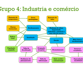
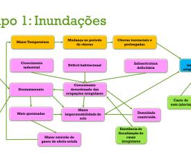
Las evaluaciones de la vulnerabilidad son fundamentales para identificar los factores de vulnerabilidad inducidos por el cambio climático. Siguiendo la terminología del IE4 del IPCC, las evaluaciones de la vulnerabilidad exploran la exposición al cambio climático, los factores de sensibilidad y la capacidad de adaptación actual. Al evaluar las causas de la vulnerabilidad, los responsables de la toma de decisiones pueden identificar posibles medidas de adaptación que contribuyan a reducirla.
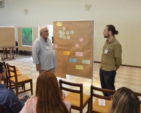
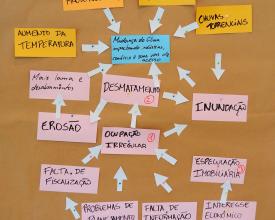
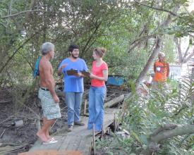
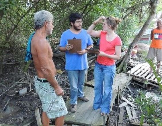
Dada la limitada disponibilidad de datos cuantitativos sólidos sobre los impactos del cambio climático, se hizo hincapié en un proceso participativo y en el uso de datos cualitativos. Básicamente, la evaluación de la vulnerabilidad se realizó en dos talleres (uno para todo el municipio y otro para un distrito especialmente vulnerable) y se centró en sistemas clave de interés previamente identificados.
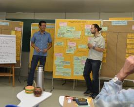
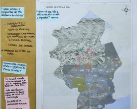
La combinación de Metaplan y otros métodos participativos durante los talleres ayudó a implicar a las partes interesadas y a movilizar sus conocimientos. Como uno de los resultados clave, un modelo de impacto que visualiza los factores de exposición, sensibilidad y capacidad de adaptación, sirvió para identificar medidas de adaptación (basadas en el ecosistema) a tener en cuenta en el plan director de la ciudad de Duque de Caxias.
Factores facilitadores
- Movilización y compromiso de las partes interesadas, incluida la incorporación y valoración de sus conocimientos.
- Las medidas dirigidas a establecer un nivel común de entendimiento entre todos los participantes al principio ayudaron a definir mejor las tareas futuras.
- Un calendario bien pensado y gestionado permite un buen seguimiento.
- La identificación y participación de las partes interesadas pertinentes para obtener información realista y validar los resultados es un factor decisivo para obtener resultados creíbles.
Lección aprendida
- Las metodologías lúdicas orientadas a centrarse en las experiencias de las personas para determinar la vulnerabilidad al cambio climático, unidas a elementos de capacitación, revelaron perspectivas que los estudios teóricos cuantitativos no habrían producido.
- Una presentación clara y fácil de usar de los resultados (mapas, cadenas de impacto) es importante para captar la atención y la aceptación de los principales interesados por los resultados del estudio principal y del taller.
- El enfoque participativo utilizado para realizar la evaluación de la vulnerabilidad se tradujo en una mayor aceptación e implicación.
- No obstante, es necesario disponer de datos cuantitativos de alta calidad, incluida la modelización climática, para aumentar la aceptación de los resultados entre los responsables de la toma de decisiones, los técnicos y la población.
Cartografía de los principales servicios ecosistémicos
El objetivo de esta etapa era cartografiar y evaluar los servicios ecosistémicos (SE) que prestan los ecosistemas de la región, utilizando el enfoque IES (Integración de los Servicios Ecosistémicos en la Planificación del Desarrollo).
El primer paso del taller fue una selección participativa de los SE más relevantes, para que puedan ser considerados en los procesos de planificación territorial. En un segundo paso, utilizando el Método Matricial, se llevaron a cabo las siguientes actividades para el mapeo de los SE:
- Creación de una base de datos (uso actual del suelo, condiciones presentes y futuras de los SE), diseño de pautas para las entrevistas.
- Cartografía de los entrevistados pertinentes (especialistas, responsables de la toma de decisiones y representantes de la comunidad), realización de las entrevistas.
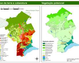
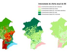
- Creación de los mapas de ES mediante SIG/QGIS. Los mapas muestran la localización e intensidad de los SE y los principales factores que conducen a la degradación de los ecosistemas.
El análisis identificó conflictos entre zonas del plan maestro actual y algunos de los paisajes que proporcionan importantes SE. Además, se identificaron varios parches de vegetación autóctona dentro de zonas urbanas como proveedores de SE, lo que aportó nueva información para la planificación urbana. La cartografía también generó por primera vez datos con información explícita sobre los servicios culturales.
Factores facilitadores
- El reconocimiento por parte de los técnicos municipales tanto de la importancia de los SE para el bienestar de la población como de la trascendencia fundamental de la protección de los ecosistemas para el municipio es clave para este paso.
- Basándose en este factor habilitador, facilitaron todos los recursos posibles para una ejecución fluida del trabajo. Como resultado, el mapeo de los servicios ecosistémicos jugó un papel clave para un diagnóstico sólido que permita considerar los servicios ecosistémicos en la planificación territorial.
Lección aprendida
- La evaluación de la ES fue una oportunidad para: (1) aumentar la participación pública en la planificación territorial; (2) sistematizar y hacer uso del conocimiento local; (3) aumentar la aceptación general de la futura propuesta de zonificación; (4) clarificar y explicitar los conflictos de uso del suelo y los usos/dependencias de los ecosistemas; y (5) añadir información valiosa al diagnóstico territorial en un lenguaje que permita una buena comprensión de todos los sectores del gobierno respecto a la importancia de cada ecosistema.
- Incluir a los principales interesados en la cartografía es vital, tanto para aumentar la legitimación de los datos y su aceptación como para garantizar la defensa de los resultados por parte de los interesados. Validar cada paso con las partes interesadas es crucial tanto para garantizar la apropiación de los resultados como para permitirles comprenderlos y defenderlos.
- Necesidad de llevar a cabo un mapeo detallado de las partes interesadas para identificar a todas las partes interesadas clave, así como de dedicar más tiempo a este proceso preliminar de selección y entrevistas.
Compromiso de las partes interesadas y desarrollo de capacidades "sobre la marcha
Un entendimiento compartido, la implicación y el compromiso de las principales partes interesadas y la disponibilidad de capacidades y recursos son fundamentales. Desde el principio, el cambio climático y los servicios ecosistémicos demostraron ser temas excelentes para aunar las opiniones de los expertos y las distintas perspectivas de las partes interesadas, lo que les permitió colaborar en torno a retos comunes.
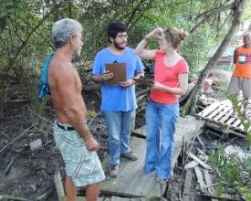
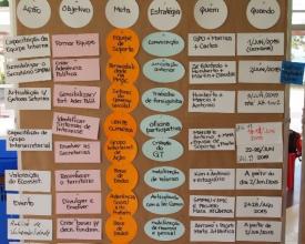
Un taller intersecretarial reunió a representantes de diferentes departamentos del gobierno municipal de Duque de Caxias. Esta (primera) oportunidad de intercambiar opiniones sobre estas cuestiones les ayudó a debatir la importancia de tener en cuenta los riesgos relacionados con el cambio climático en sus instrumentos de planificación municipal. La identificación participativa de los impactos del cambio climático fomentó un entendimiento común del cambio climático como cuestión transversal que afecta a todos los sectores municipales. La mezcla de aportaciones, debates y trabajo sobre el caso concreto reforzó el espíritu de cooperación y la búsqueda de sinergias en la preparación para la adaptación al cambio climático (basada en los ecosistemas) en la región de Duque de Caxias.
El resultado final fue la creación de un grupo de trabajo interdepartamental sobre el cambio climático, que busca la coordinación y la cooperación para potenciar el éxito de la adaptación.
Factores facilitadores
- Fuerte apropiación del proceso por parte del municipio.
- Conciencia de la necesidad de mejorar el procedimiento de planificación y voluntad de aplicar las medidas necesarias.
- Reducción al mínimo de las intervenciones frontales durante los talleres, dando a los participantes la mayor apropiación posible del proceso y, por tanto, permitiéndoles debatir y aprender "haciendo".
Lección aprendida
- El cambio climático y el enfoque de los servicios ecosistémicos demostraron ser temas excelentes para reunir a expertos y partes interesadas con visiones diferentes, permitiéndoles colaborar en retos comunes.
- Introducir la vulnerabilidad al cambio climático y los servicios ecosistémicos como cuestiones transversales, en lugar de temas separados, aumentó la probabilidad de que fueran considerados un tema de gran valor.
- La combinación de talleres con elementos de desarrollo de capacidades ayudó a sensibilizar a representantes de distintos sectores sobre la necesidad de cooperar y coordinarse para reducir riesgos específicos.
- El desarrollo conjunto de puntos de partida y pasos concretos para considerar la vulnerabilidad al cambio climático y los servicios ecosistémicos en los procesos de planificación disminuye el estrés de los equipos de planificación locales.
Impactos
Durante el proceso de revisión se han tenido en cuenta la vulnerabilidad al cambio climático y el flujo de servicios ecosistémicos. Se espera que el plan incluya más medidas de adaptación basadas en los ecosistemas. Entre las posibles medidas se incluyen más esfuerzos para conservar el bosque atlántico, los humedales y los manglares con el fin de, por ejemplo, mejorar el suministro de agua potable y reducir la erosión costera debida a la subida del nivel del mar. La restauración y conservación de los bosques en las laderas de las montañas actuará como barrera natural para reducir el creciente riesgo de corrimientos de tierras.
El proceso de debate sobre la vulnerabilidad al cambio climático y los servicios ecosistémicos también resultó ser el primer tema en años que reunió a participantes de distintas secretarías municipales: como el cambio climático está afectando a distintos sectores y no existen conocimientos sobre cómo abordar esta cuestión, se creó un grupo de trabajo sobre el cambio climático de distintas secretarías, con el objetivo de planificar acciones comunes.
Beneficiarios
Todos los sectores del municipio, con especial atención a la población vulnerable.
Objetivos de Desarrollo Sostenible
Historia
La ciudad de Duque de Caxias sufre una serie de presiones relacionadas y no relacionadas con el clima, como inundaciones, erosión costera, intrusión de agua salada, calor extremo y una falta crónica de agua potable.
El próximo proceso de revisión del plan director municipal se vio, por tanto, como una oportunidad para abordar mejor los riesgos derivados de las presiones actuales y futuras asociadas al cambio climático y a los servicios ecosistémicos. Por consiguiente, se necesitaban enfoques y herramientas adecuados para incorporar sistemáticamente estas novedades en el procedimiento de planificación. Para ello, la administración municipal de la ciudad contó con la ayuda de dos proyectos de cooperación internacional, ejecutados por el Ministerio de Medio Ambiente de Brasil y la GIZ (a través de IKI/BMUB).
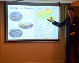
Inicialmente, técnicos del municipio participaron en una formación sobre AbE y ordenación del territorio, así como en los conceptos de servicios ecosistémicos (SE) y cómo utilizar el enfoque de Integración de Servicios Ecosistémicos (ISE) en el proceso de planificación. Posteriormente, el Departamento Municipal de Planificación invitó a varias partes interesadas (incluidas otras ocho secretarías municipales) a recibir formación sobre adaptación al cambio climático y a diseñar un plan de acción para los siguientes pasos:
- Un mapeo de los servicios ecosistémicos aplicando el modelo matricial, que es una valoración social de los servicios ecosistémicos que recoge tanto el conocimiento experto como el local a través de una elicitación de expertos dentro de una región definida. Este método se combinó con mapeos participativos, realizados dentro de la misma entrevista. Los mapas resultantes ponen de relieve las zonas relevantes para la provisión de 9 servicios ecosistémicos diferentes, así como los factores impulsores de la disminución de la provisión de servicios ecosistémicos. Los resultados de la cartografía de los servicios ecosistémicos ofrecen nuevas percepciones sobre los servicios ecosistémicos y sus valores, así como sobre las tendencias previstas en el futuro, y responden a la necesidad de información espacial explícita de los responsables locales de la toma de decisiones.
- Evaluación participativa de la vulnerabilidad al cambio climático. Aunque se disponía de muy pocos datos cuantitativos, el equipo se decidió por un enfoque principalmente cualitativo que incluía un fuerte impulso al desarrollo de capacidades. Un taller introductorio sirvió para sensibilizar a los participantes sobre la importancia de tener en cuenta el cambio climático en la planificación y la terminología relacionada. Sobre esa base, se llevó a cabo una evaluación de la vulnerabilidad a escala local. Los resultados incluyen información sobre la vulnerabilidad y los riesgos, una cartografía de las zonas sensibles y posibles medidas de adaptación (basadas en los ecosistemas).

