Participatory monitoring
  • The participatory monitoring aims to develop a greater understanding of natural resource health and the impacts of anthropogenic activities within local communities through a socially integrated resource assessment.

  • The participatory ecological monitoring process begins with an initial village meeting to inform the purpose of the activities, select indicator species, monitoring sites and a local monitor team.

  • The local monitoring teams are either designated or elected by community members at the village level or can be volunteers. However, they should at least be able to read/write and count. A local monitoring team consists of five people per village and contains male and female.

  • The monitoring method is developed by the support organization and the monitoring has a simple design and method to be accessible to anyone, irrespective of educational level (using simple count of cut stump to assess the amount of carbon loss; measuring the tree height with graduated pole wood to measure tree biomass and carbon).

  • Local monitors were trained by the technical staff from the support organization on the method before conducting the fieldwork.

  • The support organization assists the community to identify the relevant indicators, these should be the key natural resources or target species providing useful information to allow local community to perceive the effectiveness of the management in place;

  • The support organization provides technical assistance in the long term monitoring and builds the capacity of the local monitors.

  • The monitoring method developed must be an effective means of illustrating to coastal communities the benefits of natural resource management. The number of cut stumps or number of mangrove mud crab holes could be a good indicator to demonstrate clearly to the community the effectiveness of the mangrove management.

  • The dissemination of the results of the monitoring helps the community to understand the state of their resources and the amount of carbon stocks in their mangrove forest. The support organization must define the key messages from the monitoring results (the carbon stocks at the mangrove reserve are much higher compared to the unmanaged mangrove forest).

  • Local monitor team is not paid but they are given a daily food allowance when they are conducting the forest inventory and carbon monitoring. The income from the sale of the carbon credits is planned to secure the long term monitoring activities.

Participatory Forest Management plan
  • A participatory management plan aims to support the local community to sustainably manage mangrove forest within the LMMA.

  • Using a printed high resolution Google Earth map, a first draft management plan is created by each concerned (proposed project area for the mangrove carbon project) village with the boundary of the mangrove zoning (core zone, reforestation area and sustainable logging area).

  • When all the relevant villages within the LMMA have completed the zoning, the data from the Google Earth map are digitized and projected on a big screen for validation. Delegates from each village are invited to attend a workshop for the validation of the mangrove zoning. For the validation, at least four people from each village must attend. Ideally both men and women are elected by villagers who they feel may best reflect their opinions (elders, chef Village).

  • Each community determines, agrees and implements the rules and regulations governing each mangrove zone.

  • This is conducted through a large village meeting. The support organization facilitates the process until the local law is ratified at the court.

  • A local convention or law enables communities to govern the natural resource management;

  • Aptitude of the support organization to incorporate the mangrove management plan into the existing LMMA management plan;

  • Ability of the law enforcement committee to enforce the Dina and deal with the fine payment in their respective zone without support/inputs from the government;

  • Demarcation of the management zone enables the community to observe on the ground the boundary of the mangrove zoning.

  • The support organization must be familiar with the government law, as the local laws/conventions (such as Dina) should not conflict with the national law. It has proven effective to involve appropriate government actors in processing the Dina (local law) at the village level to make the ratification easy.

  • Make sure villages sharing mangrove forest are consulted together through village meetings/workshops for a compromise on the mangrove zoning. For the demarcation at the forest, delegates from villages at the AOI must assist the technician staff from the support organization to make sure that the marks/signs are in the right place.

  • Colour of the marks/signs used for the demarcation should consistently be within the LMMA (e.g colour red for the core zone boundary for both marine area and mangrove forest).

Participatory theory of change
  • The participatory concept model and strategy development exercise aims to identify the drivers and underlying causes of mangrove loss; and to identify potential strategies/solutions that could be implemented to reduce threats to mangrove and promote sustainable mangrove use.

  • At the end of the exercise the community has developed a concept model. This model depicts the drivers of mangrove loss in their community and the additional factors which contribute to this loss.

  • They identify solutions and work through the activities they need to implement to reach their desired results through a theory of change (ToC).

  • The exercise is carried out with community members in a focus group format development of the concept model and ToC is completed using different coloured paper and chalk.

  • Following the participatory meetings the final concept model with threat ratings, and ToC models are digitized using MiradiTM (2013) software.

  • Announcement of the planning is sent to village leader prior to the exercise;

  • High participation and presence of all stakeholders during the exercise and participants should be fully aware of the purpose of the exercise;

  • The facilitator from the support organization has enough skills and is familiar with the concept model exercise and able to motivate people to express their idea;

  • The support organization is able to adapt to the local context (using the available materials).

To address community reticence and for stronger dialogue within the community, employing two community-based facilitators from the village to assist the Theory of change exercise is recommended. Good practice includes hiring people already engaged in the LMMA management (dina enforcement committee, mangrove commission, women’s group) activities. The community-based facilitators are trained by the technical staff from the support organization in advance of the participatory theory of change exercise. Volunteers from the community should be invited to present the outcome from their group work, aiming to assess the level of consensus on the concept model they developed. It is vital to ensure representation from key stakeholder groups, particularly women and young people who may otherwise be marginalised. If needed, separate women and men in different groups to facilitate open discussion.

Participatory mapping for management

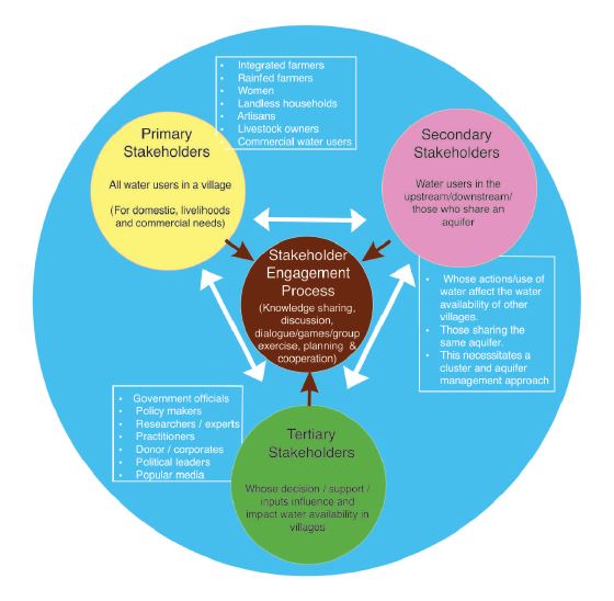
Participatory mapping is undertaken with communities to understand spatial patterns (land use, land tenure, land cover type and historical change and trend) and the state and use of mangrove resources in the project area.The participatory mapping creates maps which will later support the management planning and zoning. Google Earth imagery covering the whole area of interest (AOI) combined with questionnaires is used to assess community perceptions of resource use. All stakeholders (farmers, loggers, fuel wood collectors, charcoal producers, lime makers, elders and fishers), identified through interviews with key informants, are involved in this exercise and create a resource use map of the AOI. They are divided according to activity groups of 5 or more. Only one person is designated to the group to draw the boundary of each land use type on the map. Ideally each group should be assisted by one staff member from the support organization. Each group comprises a range of sex and age (male and female/young and old) that are already active in the respective activities (usually over 15 years old).

  • High resolution Google Earth map of the area is available and contains familiar landmarks (e.g school building, church) to facilitate community reading.

  • The questionnaires for the stakeholders aiming to gather additional information about the resources used are available and translated into local dialect to avoid confusion.

  • Good engagement with the community in advance of the mapping to ensure convenient timing and optimal participation. 

  • The mapping exercise should last 2-3 hours to enable community members to balance participation with other commitments. 

  • The staff from the support organization should be familiar with the local dialect and avoid using scientific/very technical words.

  • Consensus between groups must be respected before drawing/delineating the boundary on the map.

  • The facilitator must be able to make a quick analysis of information given by the community during the exercise.

Conservation Gains Will Only Come through Partnerships

Conserving nature requires the involvement of many players, each having different goals, thus advances can only be made through partnerships. Here we have formed a very successful partnership between the provision of health care and conservation. This involves partnerships between the Uganda Wildlife Authority, the Ministry of Health, local government, Makerere University, Wilson Center, George Washington University, McGill University, Wildlife Conservation Society, and international donors.

Colin Chapman has worked in Uganda for 32+ years, trained 58 advanced degree students (many are now in position of authority in Uganda), worked with the Uganda Wildlife Authority since its inception, and is well respected by the local community.

Forming meaningful partnerships, where the goals of all partners can be met, is the only way to produce meaningful conservation advances.

Bushmeat Hunting and Resource Extraction are a Constant Threat to Biodiversity

The bushmeat trade is a large industry that is decimating many wildlife populations, even those in protected areas. It is estimated that up to 4 million tonnes of bushmeat are extracted each year from Central Africa alone ( the weight of ~5.7 million cattle).  For the people’s perspective the resources from parks allow them to feed their families and raise money to send children to school.

We have been greatly aided by the Uganda Wildlife Authority that protects the part, monitors illegal encroachment and engages in revenue sharing and outreach to help local people. The mission statement of the Uganda Wildlife Authority is to “To conserve, economically develop and sustainably manage the wildlife and protected areas of Uganda in partnership with neighboring communities and other stakeholders for the benefit of the people of Uganda and the global community.”

Through the hard work of a Ugandan Wildlife Authority, we have been able to analyze data on the poaching level and understand the economic pressures causing increased activities and which conservation actions are effective at decreasing these activities. We have learned that our joint efforts have led to forest recovery the growth of wildlife populations in the park

Working with the people and for the people

In the previous building block,  the importance of working on and for a common land and taking on common problems was mentioned. For COBIJA members, the common goal is furthermore to do a job with people and for people, promoting social change, strengthening the ways of life of the peasants, and strengthening the sustainable management of key resources such as water and soil. The approach is to generate change by working with the people, for instance to maintain processes for the sustainability of productive projects, or to develop capacities for food security, among others.

  • Using existing levels of organization within communities, producers, and local authorities in order to build initiatives, e.g. Ejido assemblies, fishing cooperatives, rural production units, etc.
  • A strong shared sense of identity and belonging among producers, communities and local authorities;
  • Thanks to the organization's network and the COBIJA Coalition, there has been a greater impact in the workshops in terms of presenting information and results to the producers and making an effective translation of the diagnoses to reality in the field.

The work experience with COBIJA has been relevant for people who do not have a network of organizations that fulfill the role of interlocutors and process accompaniers. There was a void of citizen voice which is being covered as the work of the Coalition progresses.

Given the novelty of the Coalition's work experience with the communities, it has been necessary to create an agile communication strategy with the people.

Working in a common landscape to create synergies in the use of ecosystem services

Sharing a same ecological and productive landscape has been pivotal for the development of COBIJA´s leadership in the region, since a common landscape stands for the development of common goals within the Coalition. Having started with the shared struggle against phyto-diseases (e.g. "coffee rust") in the coffee plantations of the Jamapa-Antigua region, the Coalition is still working with small coffee producers, along with beekepers and honey producers. Support goes to the sustainable use of the surrounding ecosystems,  including water and land management at the local and landscape levels, to maintain the provision of ecosystem services and the productive activities related to them.

By working for a common landscape, the grassroots organizations have been able to focus their efforts, to share their experiences, and to gain access to more funding to solve the various social and environmental issues in the region.

  • A network of grassroots organizations with sufficient experience so that they can hold a shared vision and leadership in order to mentor local producers and other stakeholders,
  • A shared landscape and territory: all organizations are in the same region and the same watershed;
  • Counting with financial resources and institutional support from a larger project that underpinned the work of the coalition.

It has been very important to develop a shared identity for the various member organizations: "Coalición COBIJA" has allowed them to have a greater projection before local and federal authorities, as well as to be recognized as an undisputed spokesperson for the interests of the local communities. More recently, the coalition has become an important reference point, advocating local people´s interest at a level of regional decisions and public policies.

Health Care is a Pressing Need That Can be Affordably Provided to Many Around Parks

In the case of tropical health, most suffering is NOT caused by a lack of effective drugs or technology, rather it is due to the simple but critical lack of accessibility to health knowledge and services. In Uganda alone, 30% of all deaths among children between the ages of 2 and 4 are caused by malaria, a disease that could be easily treated or prevented, and 26% of children under the age of 5 are malnourished. These trends are most severe in remote regions where health services and education are extremely limited. Remote areas are also often home to protected areas for wildlife.  Through local clinics or mobile clinics, it is possible to provide critical health services to many people at a small cost per individual.  The number of people receiving benefits  are many times greater than other types of revenue sharing, such as ecotourism.

The Uganda Wildlife Authority, manage national parks, and they have enabled our outreach by providing a ranger to talk to the communities whenever the mobile clinic is in actions.  They have also provided the driver.  The Ministry of Health has provided us up to 3 local nurses to accompany the mobile clinic.  Furthermore, the Ministry provides many drugs for free, including medicine for HIV, deworming, and vaccinations.  The vaccinations will be particularly important this coming year to beat back COVID.

Through the hard work of a Ugandan student, we demonstrated that by providing health care through our mobile clinic, we can improve how the local people perceive the park - improving parks-people relationships.  Long-term monitoring of wildlife populations show that this corresponds to increases in wildlife populations.

Integrated (EarthRanger) platform solution design

EarthRanger provides the platform for integration but the data sets and information to be integrated needed to be determined. Ol Pejeta therefore designed the platform solution, adapting it meet the conservancy’s needs – evaluating what information would be useful and how it could be integrated. This was partly based on what data was readily available as well as understanding the key factors in supporting critical operations. This included combining data from the field (animal, radio, vehicle tracking) to inform security and ecological monitoring efforts. Cameras that monitor wildlife corridors also provide alerts if vehicles, people, or animals pass by. The Conservancy also operates an integrated livestock and wildlife land management approach. Livestock bomas are mapped and if collared predators are close an alert is sent so teams can respond accordingly.

  • Problem solving – focus on what the needs are and exploring how technology can support rather than being solution led
  • Operational focus – grounded in conservation, understanding all areas of operations, important data, and user requirements to inform solution design.
  • Supporting infrastructure & systems – source platforms (digital radio, vehicle monitoring, animal tracking) to be in place to enable integration.
  • Skills and partnership – technical skills within the team deploying the solution and or partnership with an organisation that can help.
  • Partnership is critical – delivering such a solution requires partnerships to be formed across different parties. The institution providing the platform, the user and deploying organization and solution providers of the different source data platforms. All these parties have to collaborate effectively to deliver a proper working solution.
  • User training and buy in is key – the users of the solution have to be properly trained and involved in order to achieve buy in and proper utilization of the solution.