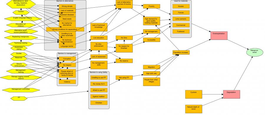
Participatory theory of change
  • The participatory concept model and strategy development exercise aims to identify the drivers and underlying causes of mangrove loss; and to identify potential strategies/solutions that could be implemented to reduce threats to mangrove and promote sustainable mangrove use.

  • At the end of the exercise the community has developed a concept model. This model depicts the drivers of mangrove loss in their community and the additional factors which contribute to this loss.

  • They identify solutions and work through the activities they need to implement to reach their desired results through a theory of change (ToC).

  • The exercise is carried out with community members in a focus group format development of the concept model and ToC is completed using different coloured paper and chalk.

  • Following the participatory meetings the final concept model with threat ratings, and ToC models are digitized using MiradiTM (2013) software.

  • Announcement of the planning is sent to village leader prior to the exercise;

  • High participation and presence of all stakeholders during the exercise and participants should be fully aware of the purpose of the exercise;

  • The facilitator from the support organization has enough skills and is familiar with the concept model exercise and able to motivate people to express their idea;

  • The support organization is able to adapt to the local context (using the available materials).

To address community reticence and for stronger dialogue within the community, employing two community-based facilitators from the village to assist the Theory of change exercise is recommended. Good practice includes hiring people already engaged in the LMMA management (dina enforcement committee, mangrove commission, women’s group) activities. The community-based facilitators are trained by the technical staff from the support organization in advance of the participatory theory of change exercise. Volunteers from the community should be invited to present the outcome from their group work, aiming to assess the level of consensus on the concept model they developed. It is vital to ensure representation from key stakeholder groups, particularly women and young people who may otherwise be marginalised. If needed, separate women and men in different groups to facilitate open discussion.

Participatory mapping for management

Participatory mapping is undertaken with communities to understand spatial patterns (land use, land tenure, land cover type and historical change and trend) and the state and use of mangrove resources in the project area.The participatory mapping creates maps which will later support the management planning and zoning. Google Earth imagery covering the whole area of interest (AOI) combined with questionnaires is used to assess community perceptions of resource use. All stakeholders (farmers, loggers, fuel wood collectors, charcoal producers, lime makers, elders and fishers), identified through interviews with key informants, are involved in this exercise and create a resource use map of the AOI. They are divided according to activity groups of 5 or more. Only one person is designated to the group to draw the boundary of each land use type on the map. Ideally each group should be assisted by one staff member from the support organization. Each group comprises a range of sex and age (male and female/young and old) that are already active in the respective activities (usually over 15 years old).

  • High resolution Google Earth map of the area is available and contains familiar landmarks (e.g school building, church) to facilitate community reading.

  • The questionnaires for the stakeholders aiming to gather additional information about the resources used are available and translated into local dialect to avoid confusion.

  • Good engagement with the community in advance of the mapping to ensure convenient timing and optimal participation. 

  • The mapping exercise should last 2-3 hours to enable community members to balance participation with other commitments. 

  • The staff from the support organization should be familiar with the local dialect and avoid using scientific/very technical words.

  • Consensus between groups must be respected before drawing/delineating the boundary on the map.

  • The facilitator must be able to make a quick analysis of information given by the community during the exercise.

Conservation Gains Will Only Come through Partnerships

Conserving nature requires the involvement of many players, each having different goals, thus advances can only be made through partnerships. Here we have formed a very successful partnership between the provision of health care and conservation. This involves partnerships between the Uganda Wildlife Authority, the Ministry of Health, local government, Makerere University, Wilson Center, George Washington University, McGill University, Wildlife Conservation Society, and international donors.

Colin Chapman has worked in Uganda for 32+ years, trained 58 advanced degree students (many are now in position of authority in Uganda), worked with the Uganda Wildlife Authority since its inception, and is well respected by the local community.

Forming meaningful partnerships, where the goals of all partners can be met, is the only way to produce meaningful conservation advances.

Bushmeat Hunting and Resource Extraction are a Constant Threat to Biodiversity

The bushmeat trade is a large industry that is decimating many wildlife populations, even those in protected areas. It is estimated that up to 4 million tonnes of bushmeat are extracted each year from Central Africa alone ( the weight of ~5.7 million cattle).  For the people’s perspective the resources from parks allow them to feed their families and raise money to send children to school.

We have been greatly aided by the Uganda Wildlife Authority that protects the part, monitors illegal encroachment and engages in revenue sharing and outreach to help local people. The mission statement of the Uganda Wildlife Authority is to “To conserve, economically develop and sustainably manage the wildlife and protected areas of Uganda in partnership with neighboring communities and other stakeholders for the benefit of the people of Uganda and the global community.”

Through the hard work of a Ugandan Wildlife Authority, we have been able to analyze data on the poaching level and understand the economic pressures causing increased activities and which conservation actions are effective at decreasing these activities. We have learned that our joint efforts have led to forest recovery the growth of wildlife populations in the park

Health Care is a Pressing Need That Can be Affordably Provided to Many Around Parks

In the case of tropical health, most suffering is NOT caused by a lack of effective drugs or technology, rather it is due to the simple but critical lack of accessibility to health knowledge and services. In Uganda alone, 30% of all deaths among children between the ages of 2 and 4 are caused by malaria, a disease that could be easily treated or prevented, and 26% of children under the age of 5 are malnourished. These trends are most severe in remote regions where health services and education are extremely limited. Remote areas are also often home to protected areas for wildlife.  Through local clinics or mobile clinics, it is possible to provide critical health services to many people at a small cost per individual.  The number of people receiving benefits  are many times greater than other types of revenue sharing, such as ecotourism.

The Uganda Wildlife Authority, manage national parks, and they have enabled our outreach by providing a ranger to talk to the communities whenever the mobile clinic is in actions.  They have also provided the driver.  The Ministry of Health has provided us up to 3 local nurses to accompany the mobile clinic.  Furthermore, the Ministry provides many drugs for free, including medicine for HIV, deworming, and vaccinations.  The vaccinations will be particularly important this coming year to beat back COVID.

Through the hard work of a Ugandan student, we demonstrated that by providing health care through our mobile clinic, we can improve how the local people perceive the park - improving parks-people relationships.  Long-term monitoring of wildlife populations show that this corresponds to increases in wildlife populations.

3- Biodiversity Monitoring

Monitoring is the sustained study of certain environmental indicators (flora, fauna, water resources, etc.) in order to establish a baseline that facilitates tracking the behavior of the environment in relation to the production systems. This information allows for implementing improvement measures in aspects related to land management while strengthening positive actions and mitigating, through corrective actions, components that may be unfavorable in the production-natural environment relationship.

Having a technical team nearby, with technical capacities to generate reliable monitoring and surveys. Also, the presence of certain “emblematic” species that generate empathy on the part of the property owners.

1- Monitoring mammals with camera traps plays a key role in developing empathy, on the part of producers, towards species that inhabit their territory.   
2- Biodiversity monitoring cannot be an end in itself. It has to help solve a problem, it has to serve to change a reality, and for that it is very important to establish a baseline with sufficient data. Undoubtedly, monitoring is particularly useful to evaluate the efficiency of corrective measures in specific situations. One example is the evaluation and search for a favorable solution to irrigation channels.
 

Integrated (EarthRanger) platform solution design

EarthRanger provides the platform for integration but the data sets and information to be integrated needed to be determined. Ol Pejeta therefore designed the platform solution, adapting it meet the conservancy’s needs – evaluating what information would be useful and how it could be integrated. This was partly based on what data was readily available as well as understanding the key factors in supporting critical operations. This included combining data from the field (animal, radio, vehicle tracking) to inform security and ecological monitoring efforts. Cameras that monitor wildlife corridors also provide alerts if vehicles, people, or animals pass by. The Conservancy also operates an integrated livestock and wildlife land management approach. Livestock bomas are mapped and if collared predators are close an alert is sent so teams can respond accordingly.

  • Problem solving – focus on what the needs are and exploring how technology can support rather than being solution led
  • Operational focus – grounded in conservation, understanding all areas of operations, important data, and user requirements to inform solution design.
  • Supporting infrastructure & systems – source platforms (digital radio, vehicle monitoring, animal tracking) to be in place to enable integration.
  • Skills and partnership – technical skills within the team deploying the solution and or partnership with an organisation that can help.
  • Partnership is critical – delivering such a solution requires partnerships to be formed across different parties. The institution providing the platform, the user and deploying organization and solution providers of the different source data platforms. All these parties have to collaborate effectively to deliver a proper working solution.
  • User training and buy in is key – the users of the solution have to be properly trained and involved in order to achieve buy in and proper utilization of the solution.
EP RESOLUTION 2

A method of combating plastic pollution and organic matter in the ocean.

The EP in collaboration with O.I.N.G PACO have set up a multi-community committee for the environment. Collective action to combat plastic pollution in the towns of the African community.

1. Effective coordination mechanisms, but less practical

2. B1000B waste management methods effective and implemented progressively

PE RESOLUTION

program created to contribute to sustainable development
the ability of states to better control the movement of populations in order to preserve the environment.
the environment.

Program goal :
(First phase)
1. study new methods and carry out in-depth research to develop new
new technologies for the development of the
ENVIRECOLOGY
2. Teach and train future Doctors, Experts, Specialists and Practitioners in the
Envirecology profession
3. Create and develop new scientific and technical bases and strengthen the methodology
methodology and expertise of Men and Women in favour of
ENVIRECOLOGY

Teaching list :

1. Certain geographical areas in Cameroon require in-depth studies in soil management,

2. The microclimate is difficult to adapt to,

3. The communities in the various regions are experiencing growth due to a lack of rehabilitation,

4. Public spaces require constant assistance to minimize the environmental footprint in urban environments,

Solutions with less impact :

1. Behavior change,

2. Unsanitary conditions,

3. Adaptation methods for behavior change,

Education, awareness, and traditional knowledge documentation

Over the past 10 years, we have focused on assessing the conservation status of endemic species and their rehabilitation in the wild. We have made a great effort to preserve it and plan for its sustainability. The most important thing that my team and I reached is that the surrounding community, users of resources, researchers, and decision-makers, whether in the site or in the government away from the place, the private sector, and students even the public can destroy everything we built during the previous years as a result of their ignorance of what we work and its importance to us and them. Dissemination of information is an external protection shield to ensure the sustainability of activities on the site. Continuous training and awareness activities should be in the target area and throughout the country in order to avoid destruction due to ignorance. Also, not documenting the traditional knowledge inherited by the local community is extremely dangerous and its loss is a waste of wealth that will cost the state and the world huge sums to discover again.

Education, awareness, and documentation, could reduce the current and future pressures and reduce the impact and the cost of recovery.

The most important factor for the success of training and awareness programs is the appropriate choice of the recipient, who preferably has contact, whether from close or from afar, with the natural resource.


Involving the community in planning and implementing conservation programs and agreeing on the sustainability and conservation of the natural resource consolidates the principle of partnership and trust and facilitates the process of documenting their knowledge.

Share with the community all your next steps and challenges and hear from them their opinions and suggestions, even if they are simple from your point of view.

Teach children in the region to understand the next generation.

Follow-up and engagement of trainees after training and awareness is very useful and works to establish and implant information within them.

Educate stakeholders about the importance of your role for their future and share the decision with them.