Ecological Mangrove Restoration
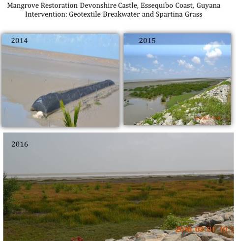
There are two approaches that have been used for mangrove ecosystem restoration worldwide. The artificial regeneration or planting approach that has been used extensively and the other approach that has been used more recently is the natural regeneration or the Ecological Mangrove Restoration (EMR) approach (http://www.mangroverestoration.com/pdfs/CBEMR-Infosheet-URLs.pdf). Guyana has adopted EMR principles to design and implement its mangrove restoration program. EMR principles purports five critical steps that are necessary to achieve successful mangrove restoration, the sixth step (seedling planting) is only recommended as a last option. Following the guiding principles of EMR, seedling planting was only used to increase recovery time of a site that met the necessary criteria, particularly elevation, to support mangrove restoration. At sites that did not meet restoration criteria, the project implemented sediment traps to aid accretion and planted Spartina grass to support soil consolidation.
Baseline information on the proposed restoration sites must be captured to determine the suitability of the site and guide selection of the most appropriate intervention. Baseline information collected should include physical (elevation, soil conditions, etc.), biological (presence of natural recruitment) and social factors (livestock grazing, harvesting, etc.). Suitable elevation is critical to successful restoration and one of the key criteria in determining the most suitable intervention.
The restoration of Guyana’s coastal mangroves is possible if planned properly with the collection of detailed baseline data on potential restoration sites. Thorough site analysis should be conducted prior to any intervention and baseline data, such as wave energy, shoreline elevation, anthropogenic activities and hydrology should be collected and analysed before any intervention is undertaken. Implementation of the EMR principles increases success rates significantly and has the potential to reduce restoration cost. Monitoring data under the GMRP indicates that when conducted on accreting sites of the right mud elevation, and soil consolidation, restoration of a protective belt of mangrove forest can be established rapidly.
Rehabilitating channels and hydrological flows in mangroves

In order for problems of salinity to be solved in perturbed mangrove ecosystems, as well as for fish production and migration to be optimized, it is vital that channels within the mangrove systems are properly cleared and maintained, even if this means cutting some trees. Clear and well-maintained channels permit the hydrological flows between salt- and freshwater sources in a mangrove to find a natural balance, favouring biodiversity. They also permit the movement of fish to and from the ecosystem in rhythm to those flows, as well as facilitating the natural expansion of the mangroves via greater seed dispersal.

- A committed local community workforce which is convinced of the benefits of rehabilitating the mangroves.

- Trained government agencies which know the best ways to rehabilitate mangroves.

- A sustainable programme of payments for temporary work by which the local community can be additionally rewarded for their service to ecosystem maintenance, thus providing additional adaptive economic capacity (see building block III).

- The keys to mangrove rehabilitation are channel restoration and maintenance, leading to improved hydrological network flows.

- Governmental programmes for temporary work payments and subsidies must not be relied upon, only, for generating local support for maintaining the mangrove ecosystems, since the money available for such programmes might not be guaranteed in the medium to long run.

- Rehabilitation and maintenance of mangroves is hard and grueling work – conviction and evidence of the benefits it brings to livelihoods is needed to sustain a community’s commitment to such a task.

Creation of conservation association unites local communities
The nine communities surrounding Mbe were helped to come together to form a single community organization to represent their interests and promote conservation. In the past, these communities have not always cooperated readily and there is some historic distrust and rivalry. The Conservation Association of the Mbe Mountains (CAMM) was created with a written constitution and officers elected to a General Assembly, Management Committee, Board of Trustees and a Technical and Supervisory Stakeholders Group. Regular CAMM meetings now promote dialogue and have improved trust between the nine communities. CAMM also represents local interests and perspectives when dealing with local and state government. WCS facilitated legal registration of CAMM in 2013 and is supporting capacity building of CAMM and construction of a headquarters.
The communities needed to trust each other and work together towards a single purpose. Significant time was needed to establish this trust, since there are frequent disagreements among the communities. Presence of an NGO to facilitate the process was critical to success. The initiative also had support from influential local politicians and businessmen as well as the Cross River State Forestry Commission – government agency responsible for the management of wildlife and forests within the state
To fully secure local land tenure the nine communities, or CAMM, require a certificate(s) of occupancy from the state government. A benefit sharing formula was required since the communities do not own equal areas of forest within the Mbe Mountains.The nine communities don’t yet trust each other fully and there are periodic disputes, which are best resolved by CAMM. Within each community there are often a number of men known as elites who typically act for selfish interests rather than for the common good. As CAMM has become stronger it has been able to reduce the influence of these elites. The influence of the Chairman of Boki Local Government Area has also helped. The penalties against poaching are low and not always enforced by CAMM. Stricter penalties may be required, legalized as local government bylaws. The CAMM constitution is large and cumbersome and needs to be streamlined. Levels of capacity within CAMM are low - needs close mentoring and long-term financial support from WCS.
Transforming the water body to nature-like banks
Given the history of the Ruhr region, the Heerener Mühlbach was a canalised water body used as an open wastewater system. Conducting a mixture of waste and storm water in a straight concrete bed, the water body got classified as heavily modified according to the EU Water Framework Directive and required that a number of problems be resolved. Discharges of wastewater in the stream derogated the ecosystem tremendously and the concrete bed of the water body and the specific management of the banks harmed biodiversity. Another problem was the dangerous shape of the canal which prohibited the recreational use of the water body. And finally, bad smell regularly disturbed the neighbourhood. As a first essential step towards ecologic enhancement, a sewer pipe was placed underground along the river. The concrete bed was then removed (apart from few exceptions, e.g. under bridges), which led the river to flow on a new sole that was higher and wider than before and meander where possible. The hard banks were converted into nature-like banks. The initial plantation is complemented by wild and natural vegetation: green plants have the chance to flourish along the blue water body.
A precondition for the nature-like development of the water body was the separation from waste water and clean surface water. Thus, the construction of the underground sewer was the absolute necessary first step. For the development of biodiversity, it was important to give as much room to the water body as possible; adjoining property was thus included in the creation of wetlands. Ultimately, the support of the community and decision-makers made the planning and implementation possible.
In other locations where water bodies were ecologically enhanced by the water board, too much initial vegetation was planted shortly after completion of the construction works. As nature develops itself as soon as the conditions are good, the vegetation grew to such an extent that the trees and shrubs required almost the full amount of water coming from the water body, turning the habitat into a purely green corridor without open water. The green-blue corridor has now developed into a balanced ecosystem with the water body and adjoining wetlands.
Evidence-based problem solving
CONANP has been forming an alliance with local universities, research centres, and NGOs, to ensure that problem solving and regulations, are guided by scientific studies and hard evidence. Examples of key products or interventions, include: 1.“Forensic ecology” activities to understand the causes of mangrove salinization resulting from the construction of road infrastructure in the 1940s, and alternatives to reverse its effects in a practicable and cost-effective manner. 2. Scientific calculations of the capacity of local water bodies to support new tourist water-borne activities 3. Market research for new non-extractive productive activities.
Identify which academic actors can support key interventions Effective contacts and history of collaboration (academia, civil society & government) Effective inter-sectoral communication: not only between government and academic sectors, but also, and most importantly, being able to communicate research questions and results to local communities. Financial resources to leverage support from the academic sector and NGOs.
The role of intermediaries between the academic sector and communities is of utmost importance for the success of this type of building block. This role can be most ably played by individual consultants and NGOs who have the capacity to effectively interpret and communicate the results of scientific knowledge to local people. The intermediaries need to be able to facilitate the flow of traditional knowledge and local information back to the academic sector. It is very important to ensure that studies are properly carried out within the local context and with the maximum of relevant information available. It is of enormous help for a governmental agency to be able to assign, to the collaborative activity behind this building block, skilled staff who can judge the relevancy and quality of the scientific knowledge being offered by the academic community. Not all scientific knowledge is of the same quality or practical relevance.
Thinking “out of the sector”: Intelligently targeted payments for key actors

CONANP decided to make use of targeted payments to create a local workforce to maintain and rejuvenate the mangroves, in order to support the fishing sector. An obvious target of the payments and a source of a workforce would be that same fishing sector. However, CONANP took the unusual step of thinking “outside of the sector”, and to involve a sector not linked at all to the problem: the local agricultural communities. CONANP noted that the livelihoods of this sector are under increasing pressure from loss of markets, reduction of soil conditions, and the loss of traditional levels of precipitation as a result of climate change. On the one hand, focusing on this sector has provided an extra source of income which increases the adaptive capacity of this group in the face of changes in rainfall patterns. On the other hand, the involvement of the agricultural communities, has had the benefit of introducing the latter to the problematic and importance of the mangrove ecosystems, creating a new ally in the fight for increased resilience. In other words it has supported inter-sectoral learning and collaboration between two groups that hardly ever interact, improving the capacity for adaptation to both sectors’ different climate risks.

Effective communication & awareness-raising by CONANP to generate a shared vision of the relevance of integrated mangrove ecosystem management among agricultural communities. Continued existence of financial resources to pay for the services of the agricultural communities supporting the rehabilitation of the mangroves; Knowledge and awareness of CONANP about the risks faced by the Mayan agricultural communities, and when they were in need it provided temporary employment.

Be prepared to “think out of the sector” for new potential allies. Instead of focusing collaboration on the usual allies, one should consider whether there are other sectors that could be involved in the EbA measure (mangrove rehabilitation) that could benefit from being involved (through reduction in their own climate risks, and increase in sources of revenue), and in return, can promote multi-sectoral collaboration and problem solving. Financial instruments or subsidies, when mismanaged, can distort local capacities for generating and maintaining sustainable livelihoods. The continued flow of such payments is not always possible in the long-term. Therefore, it is important that such payments are not deemed an end in themselves, but are applied in a manner that is supportive, and not substitutive, of local livelihoods.

Increasing the resilience of alternative local ecosystems that can provide habitats to lobster species
Whilst it is not easily possible to recover the sand bank habitat, it is possible to rehabilitate the local mangroves that have been in decline in recent years, in order to increase the capacity of habitat in the local mangrove to support the lobster in their early developmental stages. The latter has been concentrated on 480 hectares near the lobster fishing communities, and has as its goal the aim of reinvigorating the populations of maturing lobster going out to sea and thus increase these populations’ adaptive capacity in the face of climate hazards.
To count with research centres’ support and scientific guidance about the causes of the mangrove degradation, and practicable solutions to reversing this degradation; To count with economic and human resources to be able to employ local communities to carry out the rehabilitation work; To count with local community support to maintain the improvements that have been achieved
Communication & alliance building between the responsible government agencies, NGOs, and academic research centres is crucial for effective mangrove rehabilitation in complex situations in which mangroves are suffering from multiple climate, anthropogenic and hydrological hazards; Without good scientific guidance, it is possible to rehabilitate mangrove ecosystems in a manner that is sustainable, and benefits local livelihoods; Creating and maintaining channels within the mangrove system for facilitating natural flows between salt- and freshwater sources is a key component for reducing salinization problems, as well as making sure that a healthy mangrove is maintained; It is important to maintain the awareness that climate change not only presents direct risks to communities and ecosystems, but also highlights existing structural weaknesses in the social-economic and ecological system.
Breakwater monitoring and maintenance
A monitoring system is used to measure sediment accretion, and to monitor the condition of the breakwater fences. In addition, natural regeneration of mangroves is monitored. During the first year after construction, functionality of the breakwater fences should be ensured through monthly visual inspections and maintenance where necessary. After one year, visual inspections and maintenance should be carried out at least after the end of every storm season. In addition, seasonal GPS surveys of the shore line at low tide can be used to see whether the breakwater fences have impacts on the shape of the coastline nearby. The natural regeneration of mangroves is documented by recording species, size and density or through fixed-point photos. The latter can also be used as a simple alternative for GPS shore line surveys.
• Know-how and manpower for regular surveys (data collection for monitoring) and routine visual construction inspections • Benchmark poles for recording vertical accretion at several transects • Fixed point photos are an easy to use tool to monitor mangrove regeneration and shoreline changes • Measurements of sediment consolidation (mud-density) • GPS survey equipment and know-how for long-term surveillance
A standardized monitoring system for the condition of breakwaters, accretion of sediments and natural regeneration of mangroves is crucial for measuring the long-term success of breakwater fences. The need for maintenance and repair works may vary considerably between sites. Long-term surveillance based on GPS surveys must include neighbouring areas to discover possible negative side effects of breakwater fences (down drift erosion). It is important to realize that once floodplains are restored and an appropriate mangrove cover is in place, mangrove protection measures must be implemented to ensure sustainability of coastal protection. Once the mangrove forest is fully established, the breakwater construction is no longer needed. This process may take several years.
Estimating benefits to make the case for investment
An elaborate ecosystem services assessment helped build the case for investment in an integrated urban river restoration, highlighting benefits relating to water, land, social and climate change issues. Assessed over 40 years, the lifetime benefits of the restoration activities were estimated at €31.2 million – a benefit-to-cost ratio of 7:1. This value-based approach to urban green infrastructure demonstrated that the restoration of the park was a cost-effective way of improving the wellbeing of the local community, particularly as compares to a purely ‘hard engineering’ solution which tends to maximise single services (flood risk etc), while generally having unintended consequences for a range of other interconnected services. The assessment and accompanying report were key in convincing funders to contribute to this project, illustrating how the combination of knowledge, data and resources can enable different sectors to successfully deliver large projects and provide a wide range of benefits far beyond what a single organisation could afford to fund alone.
An Ecosystem Services Assessment was conducted. The involvement of the Environment Agency as a partner helped in the process of securing the numerous approvals needed (flood risk, contaminated land, soil disposal etc.) to successfully conduct the assessment and gather the needed data. This cooperation lead to a quantified estimate of benefits from all of the proposed restoration work prior to implementation, as well as an analysis post-implementation.
It remains difficult to monitor and quantify the benefits of ecosystem services, especially supporting services such as nutrient cycling and habitat for wildlife. Nevertheless, it is crucial in evaluating ecosystem services to consider and – to the extent possible - quantify all service categories (provisioning, regulatory, cultural and supporting). In the case of Mayesbrook, the assessment found that more than 88 percent of the total ecosystem service benefits assessed for the park were benefits to health (such as improving air quality), risk (such as reducing potential flood damage) and cultural value (such as providing opportunities for education). Thus, by creating a thriving, multifunctional landscape and combining social and environmental regeneration goals, the Mayesbrook Climate Change Park demonstrates how an urban river park restoration can successfully deliver public, private and voluntary sector objectives simultaneously – a key factor in making the investment case.
Fostering win-win solutions through innovative partnerships for landscape engineering
Within the Wallasea Project, land-raising and landscape engineering was innovatively approached by creating a novel public private partnership. Materials from the Crossrail tunneling project were transported to a low-lying coastal area at high risk of flooding, in order to raise the land. The project thus established a precedent for using largely waste material generated by a major infrastructure project to meet biodiversity conservation and climate change adaptation aims elsewhere. Financing stemmed from both the private company Crossrail as well as from the Environment Agency, with all parties profiting due to the economic as well as environmental benefits set off by recycling the leftover materials. With Crossrail on board as a delivery partner, the project represents a partnership between Europe's largest civil engineering project and Europe's largest intertidal habitat creation project.
Instead of paying to remove waste materials from tunnel construction, Crossrail opted to transport them to Wallasea Island. An unloading facility enabled the materials to be shipped and then distributed across the island to build the habitats. Crossrail covered most costs (e.g. land purchase and some staff costs), with the Environment Agency (RA) funding the rest. The EA `bought` into the project to deliver replacement habitats for areas impacted/lost within the local Natura 200 network.
While sufficient buy-in was obtained by RSPB to buy the land, funds had not initially been collected to carry out the project itself. At this point, Crossrail came forward with an offer of materials and funding that permitted the project to move forward with more confidence. The main lesson learned is thus to think ‘outside the box’ and consider novel (public-private) partnerships to tap into previously unconsidered resources, and making sure to highlight the range of benefits which will be delivered to each party as a result of the project. Furthermore, a strong relationship with the landowner was particularly important in the early design phases of the project, as this led to the ability of RSPB to take out a two-year purchase option. This meant that, for a two-year period, RSPB could purchase the majority of the island if they decided to, and the price would be fixed at the beginning of this period, thereby creating some certainty surrounding the initial costs of the project.